Barton Copse

Wood, Forest in Devon West Devon

England

Barton Copse

West Road after Gregory's Bridge
West Road after Gregory's Bridge Credit: Mr Ignavy

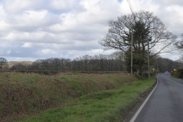
Barton Copse is a beautiful woodland area located in Devon, England. Covering an area of approximately 30 hectares, this ancient forest is home to a rich diversity of flora and fauna. The woodland is predominantly made up of broadleaf trees such as oak, ash, and beech, creating a lush and vibrant canopy overhead.

Visitors to Barton Copse can enjoy peaceful walks through the winding paths that meander through the trees, providing opportunities to spot a variety of wildlife including deer, squirrels, and a multitude of bird species. The forest floor is carpeted with a lush carpet of ferns, mosses, and wildflowers, adding to the enchanting atmosphere of the woodland.

Barton Copse is a popular destination for nature lovers, photographers, and hikers looking to escape the hustle and bustle of city life and immerse themselves in the tranquility of nature. The forest is also a valuable habitat for a number of rare and protected species, making it an important conservation area in the region.

Overall, Barton Copse is a hidden gem in Devon, offering a peaceful retreat for those seeking to reconnect with the natural world.

If you have any feedback on the listing, please let us know in the comments section below.

Barton Copse Images

Images are sourced within 2km of 50.825624/-4.1417878 or Grid Reference SS4905. Thanks to Geograph Open Source API. All images are credited.

West Road after Gregory's Bridge
Crossing Gregory's Bridge The stream is known as Mussel Brook, it flows from left to right in this view and will shortly join the river Torridge.
Crossing Gregory's Bridge
The stream is known as Mussel Brook, it flows from left to right in this view and will shortly join the river Torridge.
Entering Sheepwash on West Road
Centre of Sheepwash Long distance cyclists often pass through here and make good use of the community shop.
Centre of Sheepwash
Long distance cyclists often pass through here and make good use of the community shop.
Houses on East Street With a view of the central square.
Houses on East Street
With a view of the central square.
Centre of Sheepwash
Centre of Sheepwash
The Half Moon Inn
The Half Moon Inn
Community shop - Sheepwash It still has a post office counter.
Community shop - Sheepwash
It still has a post office counter.
War memorial - Sheepwash
The Half Moon Inn
The Half Moon Inn
Crossing Sheepwash Bridge I quote from a local history (Devon Perspectives):

"Sheepwash Bridge across the Torridge to the south of the village was built in the 17th century. After the only son of the wealthy local landowner John Tosbury was swept away while crossing the ford when the river was in spate, his grief-stricken father underwrote the building and maintenance of a bridge in memory of his drowned son.

By 1695 trustees had been appointed to secure the upkeep of the bridge. As the income from the Tosbury estates proved more than sufficient to maintain the bridge, John gave instructions that the surplus be used for the benefit of the people of Sheepwash. So the Bridgeland Trust was born and to this day it provides for deserving cases of hardship in the community, as well as going towards the upkeep of the church and chapel."
Crossing Sheepwash Bridge
I quote from a local history (Devon Perspectives): "Sheepwash Bridge across the Torridge to the south of the village was built in the 17th century. After the only son of the wealthy local landowner John Tosbury was swept away while crossing the ford when the river was in spate, his grief-stricken father underwrote the building and maintenance of a bridge in memory of his drowned son. By 1695 trustees had been appointed to secure the upkeep of the bridge. As the income from the Tosbury estates proved more than sufficient to maintain the bridge, John gave instructions that the surplus be used for the benefit of the people of Sheepwash. So the Bridgeland Trust was born and to this day it provides for deserving cases of hardship in the community, as well as going towards the upkeep of the church and chapel."
Sheepwash Bridge to Hatherleigh A pleasant lane which more or less follows the Torridge valley. Liable to flooding.
Sheepwash Bridge to Hatherleigh
A pleasant lane which more or less follows the Torridge valley. Liable to flooding.
Sheepwash Bridge to Hatherleigh Country lane which is also a sector of the National Cycle Route 27.
Sheepwash Bridge to Hatherleigh
Country lane which is also a sector of the National Cycle Route 27.
Sheepwash Bridge to Hatherleigh
Footpath and access road to Warren Farm The first part of this track follows the line of the dismantled Southern Railway Halwill and Torrington line; there was formerly a level crossing for the road and railway here
Footpath and access road to Warren Farm
The first part of this track follows the line of the dismantled Southern Railway Halwill and Torrington line; there was formerly a level crossing for the road and railway here
The Golden Inn, Highampton Repainted since 2007 when it was white <a href="https://www.geograph.org.uk/photo/372752">SS4804 : Highampton: Golden Inn</a> (also white in Google Streetview in 2011)
The Golden Inn, Highampton
Repainted since 2007 when it was white SS4804 : Highampton: Golden Inn (also white in Google Streetview in 2011)
A3072 west of Highampton Approaching the end of the 30mph speed limit zone; on the left deep ditch and bank at the roadside bordering fields which slope south to a small stream
A3072 west of Highampton
Approaching the end of the 30mph speed limit zone; on the left deep ditch and bank at the roadside bordering fields which slope south to a small stream
Lower Longwood Ford The road to Sheepwash is signed 'Road Liable to Flooding' at this point at Lower Longwood.
Lower Longwood Ford
The road to Sheepwash is signed 'Road Liable to Flooding' at this point at Lower Longwood.
Show me another place!

Barton Copse is located at Grid Ref: SS4905 (Lat: 50.825624, Lng: -4.1417878)

Administrative County: Devon

District: West Devon

Police Authority: Devon and Cornwall

What 3 Words

///yawned.dives.period. Near Hatherleigh, Devon

Nearby Locations

Barton Copse

Related Wikis

Highampton

Highampton is a parish in Devon spread over approx. 4½ miles. It stands on a ridge with views of Dartmoor and Exmoor. Highampton is about 10 miles from...

Sheepwash, Devon

Sheepwash is a village and civil parish on the southern border of the local government district of Torridge, Devon, England. The parish, which lies about...

Hole railway station

Hole Railway Station was a small halt on the North Devon and Cornwall Junction Light Railway in the U.K. between Torrington and Halwill Junction, serving...

Black Torrington

Black Torrington is a village and civil parish in Torridge, Devon, England, situated between the towns of Holsworthy and Hatherleigh. It is located on...

Nearby Amenities

Located within 500m of 50.825624,-4.1417878
Generator Method: photovoltaic
Generator Output Electricity: yes
Generator Source: solar
Generator Type: solar_photovoltaic_panel
Location: roof
Power: generator
Lat/Long: 50.8219939/-4.1452313
Generator Method: photovoltaic
Generator Output Electricity: yes
Generator Source: solar
Generator Type: solar_photovoltaic_panel
Location: roof
Power: generator
Lat/Long: 50.8219279/-4.1452286
The data included in this document is from www.openstreetmap.org. The data is made available under ODbL.

Have you been to Barton Copse?

Leave your review of Barton Copse below (or comments, questions and feedback).