Bohetherick Wood

Wood, Forest in Cornwall

England

Bohetherick Wood

Malt House Malt House, Cotehele Quay, Cornwall.
Malt House Credit: Nathan Hadley

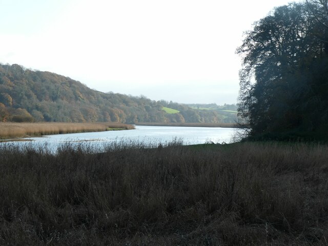
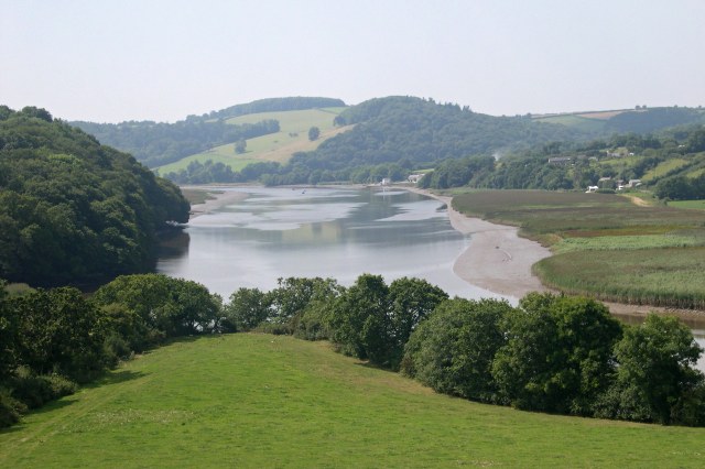
Bohetherick Wood is a captivating forest located in Cornwall, England. Spread over an area of approximately 100 acres, this woodland is a haven for nature lovers and adventure enthusiasts alike. Situated on the outskirts of the picturesque village of St Dominick, it offers a serene and tranquil retreat from the hustle and bustle of city life.

The wood boasts an enchanting mix of both native and exotic trees, including oak, beech, ash, and birch. These towering giants create a dense canopy that filters sunlight, creating a dappled effect on the forest floor. The undergrowth is abundant with ferns, mosses, and wildflowers, adding to the magical ambiance of the woodland.

A network of well-maintained footpaths and trails wind their way through Bohetherick Wood, allowing visitors to explore its natural wonders at their own pace. The paths meander through ancient groves, past babbling brooks, and up gentle inclines that offer panoramic views of the surrounding countryside.

The woodland is home to a diverse range of wildlife, making it a popular spot for birdwatchers and nature photographers. Visitors may catch a glimpse of red foxes, badgers, and even elusive deer if they are lucky. The canopy is also alive with the songs of various bird species, including woodpeckers, owls, and warblers.

Bohetherick Wood is a cherished gem in the Cornish countryside, and its untouched beauty attracts visitors throughout the year. Whether it is for a leisurely stroll, a family picnic, or simply to immerse oneself in the wonders of nature, this forest provides a serene and captivating experience for all who venture into its depths.

If you have any feedback on the listing, please let us know in the comments section below.

Bohetherick Wood Images

Images are sourced within 2km of 50.488937/-4.2259294 or Grid Reference SX4267. Thanks to Geograph Open Source API. All images are credited.

Malt House Malt House, Cotehele Quay, Cornwall.
Malt House
Malt House, Cotehele Quay, Cornwall.
River Tamar, Cotehele Quay The River Tamar at Cotehele Quay, Cornwall.
River Tamar, Cotehele Quay
The River Tamar at Cotehele Quay, Cornwall.
Cotehele Quay Limekilns <span class="nowrap"><a title="https://historicengland.org.uk/listing/the-list/list-entry/1311769?section=official-listing" rel="nofollow ugc noopener" href="https://historicengland.org.uk/listing/the-list/list-entry/1311769?section=official-listing">Link</a><img style="margin-left:2px;" alt="External link" title="External link - shift click to open in new window" src="https://s1.geograph.org.uk/img/external.png" width="10" height="10"/></span>
Cotehele Quay Limekilns
Departing Bere Alston After reversing in the platform at Bere Alston, a train from Plymouth heads for Calstock and Gunnislake. Today all the trains on this branch perform this manoeuvre providing a service to the villages of the Tamar Valley that have poor road connections with Plymouth. Until 1966 Bere Alston was a junction on the main former Southern Railway route between Exeter and Plymouth and the self-contained branch ran to Callington. The branch was cut back to Gunnislake in that year and shortly afterwards the main line was closed as a through route leaving the basic service pattern that has persisted ever since. There is no signal box here and the points are operated by the train crew using a pair of levers that can be seen at the end of the platform.
Departing Bere Alston
After reversing in the platform at Bere Alston, a train from Plymouth heads for Calstock and Gunnislake. Today all the trains on this branch perform this manoeuvre providing a service to the villages of the Tamar Valley that have poor road connections with Plymouth. Until 1966 Bere Alston was a junction on the main former Southern Railway route between Exeter and Plymouth and the self-contained branch ran to Callington. The branch was cut back to Gunnislake in that year and shortly afterwards the main line was closed as a through route leaving the basic service pattern that has persisted ever since. There is no signal box here and the points are operated by the train crew using a pair of levers that can be seen at the end of the platform.
Bere Alston Station Only one platform remains in use at Bere Alston; trains from Plymouth stop here and reverse onto the branch for Gunnislake. On the whole the facilities are tidy, if basic, and the restored former signal box looks very smart.
Bere Alston Station
Only one platform remains in use at Bere Alston; trains from Plymouth stop here and reverse onto the branch for Gunnislake. On the whole the facilities are tidy, if basic, and the restored former signal box looks very smart.
Junction for Bere Alston Station This is the end of Station Road; the road off to the right which actually leads up to the station is called New Road. The lane leading straight on under the railway is unnamed. The signpost might give the impression that the Tamar Valley Line is a steam worked heritage railway but it is in fact part of the National Rail network.
Junction for Bere Alston Station
This is the end of Station Road; the road off to the right which actually leads up to the station is called New Road. The lane leading straight on under the railway is unnamed. The signpost might give the impression that the Tamar Valley Line is a steam worked heritage railway but it is in fact part of the National Rail network.
Bere Alston Signal Box The signal box on the disused up platform at Bere Alston is original to the line, opening in 1890. It ceased to be an operational signal box in 1970, two years after the line towards Tavistock was closed, but continued to be used for some years as a messroom for the track maintenance gang. It has now been completely restored, as an initiative by the Devon and Cornwall Rail Partnership, for use by the local scouts as a potting shed. The scouts have taken on responsibility for the planters on the station. This may well be a unique role for a former signal box and the building certainly looks smart. See <span class="nowrap"><a title="https://dcrp.org.uk/bere-alston-old-signalbox-restored-for-scouts-potting-shed/" rel="nofollow ugc noopener" href="https://dcrp.org.uk/bere-alston-old-signalbox-restored-for-scouts-potting-shed/">Link</a><img style="margin-left:2px;" alt="External link" title="External link - shift click to open in new window" src="https://s1.geograph.org.uk/img/external.png" width="10" height="10"/></span> for more details of the project.
Bere Alston Signal Box
The signal box on the disused up platform at Bere Alston is original to the line, opening in 1890. It ceased to be an operational signal box in 1970, two years after the line towards Tavistock was closed, but continued to be used for some years as a messroom for the track maintenance gang. It has now been completely restored, as an initiative by the Devon and Cornwall Rail Partnership, for use by the local scouts as a potting shed. The scouts have taken on responsibility for the planters on the station. This may well be a unique role for a former signal box and the building certainly looks smart. See LinkExternal link for more details of the project.
Cotehele courtyard The lovely buildings cared for by the National Trust.
Cotehele courtyard
The lovely buildings cared for by the National Trust.
Path to Cotehele Mill (1) with winter colour A National Trust is an organization dedicated to preserving the cultural or environmental treasures of a particular geographic region. They generally operate as private non-profit organizations, although some receive considerable support from their national government. The first such organization was the National Trust for Places of Historic Interest or Natural Beauty, which is the National Trust of England, Wales and Northern Ireland, formed in 1895 and operating as a charitable organisation. 

Extract from Wikipedia <span class="nowrap"><a title="http://en.wikipedia.org/wiki/National_Trust" rel="nofollow ugc noopener" href="http://en.wikipedia.org/wiki/National_Trust">Link</a><img style="margin-left:2px;" alt="External link" title="External link - shift click to open in new window" src="https://s1.geograph.org.uk/img/external.png" width="10" height="10"/></span>

List of National Trust places <span class="nowrap"><a title="http://en.wikipedia.org/wiki/List_of_National_Trust_properties_in_England" rel="nofollow ugc noopener" href="http://en.wikipedia.org/wiki/List_of_National_Trust_properties_in_England">Link</a><img style="margin-left:2px;" alt="External link" title="External link - shift click to open in new window" src="https://s1.geograph.org.uk/img/external.png" width="10" height="10"/></span>
Path to Cotehele Mill (1) with winter colour
A National Trust is an organization dedicated to preserving the cultural or environmental treasures of a particular geographic region. They generally operate as private non-profit organizations, although some receive considerable support from their national government. The first such organization was the National Trust for Places of Historic Interest or Natural Beauty, which is the National Trust of England, Wales and Northern Ireland, formed in 1895 and operating as a charitable organisation. Extract from Wikipedia LinkExternal link List of National Trust places LinkExternal link
Path to Cotehele Mill (2) with winter colour For the Christmas period, the path was lined with lights
Path to Cotehele Mill (2) with winter colour
For the Christmas period, the path was lined with lights
Path to Cotehele Mill (3) with winter colour A National Trust is an organization dedicated to preserving the cultural or environmental treasures of a particular geographic region. They generally operate as private non-profit organizations, although some receive considerable support from their national government. The first such organization was the National Trust for Places of Historic Interest or Natural Beauty, which is the National Trust of England, Wales and Northern Ireland, formed in 1895 and operating as a charitable organisation. 

Extract from Wikipedia <span class="nowrap"><a title="http://en.wikipedia.org/wiki/National_Trust" rel="nofollow ugc noopener" href="http://en.wikipedia.org/wiki/National_Trust">Link</a><img style="margin-left:2px;" alt="External link" title="External link - shift click to open in new window" src="https://s1.geograph.org.uk/img/external.png" width="10" height="10"/></span>

List of National Trust places <span class="nowrap"><a title="http://en.wikipedia.org/wiki/List_of_National_Trust_properties_in_England" rel="nofollow ugc noopener" href="http://en.wikipedia.org/wiki/List_of_National_Trust_properties_in_England">Link</a><img style="margin-left:2px;" alt="External link" title="External link - shift click to open in new window" src="https://s1.geograph.org.uk/img/external.png" width="10" height="10"/></span>
Path to Cotehele Mill (3) with winter colour
A National Trust is an organization dedicated to preserving the cultural or environmental treasures of a particular geographic region. They generally operate as private non-profit organizations, although some receive considerable support from their national government. The first such organization was the National Trust for Places of Historic Interest or Natural Beauty, which is the National Trust of England, Wales and Northern Ireland, formed in 1895 and operating as a charitable organisation. Extract from Wikipedia LinkExternal link List of National Trust places LinkExternal link
Path to Cotehele Mill (4) with winter colour Besides the string of lights, there were several wooden reindeer by the path during the Christmas season
Path to Cotehele Mill (4) with winter colour
Besides the string of lights, there were several wooden reindeer by the path during the Christmas season
Cotehele Mill A National Trust is an organization dedicated to preserving the cultural or environmental treasures of a particular geographic region. They generally operate as private non-profit organizations, although some receive considerable support from their national government. The first such organization was the National Trust for Places of Historic Interest or Natural Beauty, which is the National Trust of England, Wales and Northern Ireland, formed in 1895 and operating as a charitable organisation. 

Extract from Wikipedia <span class="nowrap"><a title="http://en.wikipedia.org/wiki/National_Trust" rel="nofollow ugc noopener" href="http://en.wikipedia.org/wiki/National_Trust">Link</a><img style="margin-left:2px;" alt="External link" title="External link - shift click to open in new window" src="https://s1.geograph.org.uk/img/external.png" width="10" height="10"/></span>

List of National Trust places <span class="nowrap"><a title="http://en.wikipedia.org/wiki/List_of_National_Trust_properties_in_England" rel="nofollow ugc noopener" href="http://en.wikipedia.org/wiki/List_of_National_Trust_properties_in_England">Link</a><img style="margin-left:2px;" alt="External link" title="External link - shift click to open in new window" src="https://s1.geograph.org.uk/img/external.png" width="10" height="10"/></span>
Cotehele Mill
A National Trust is an organization dedicated to preserving the cultural or environmental treasures of a particular geographic region. They generally operate as private non-profit organizations, although some receive considerable support from their national government. The first such organization was the National Trust for Places of Historic Interest or Natural Beauty, which is the National Trust of England, Wales and Northern Ireland, formed in 1895 and operating as a charitable organisation. Extract from Wikipedia LinkExternal link List of National Trust places LinkExternal link
River Tamar south of Cotehele The Tamar (Cornish: Dowr Tamar) is in south west England, it forms most of the border between Devon and Cornwall. 
The Tamar's source is 3 miles from the north Cornish coast, but it flows southward and its course runs across the peninsula to the south coast. The total length of the river is 61 miles. At its mouth, the Tamar flows into the Hamoaze before entering Plymouth Sound. Tributaries of the river include the rivers Inny, Ottery, Kensey and Lynher (or St Germans River) on the Cornish side, and the Deer and Tavy on the Devon side.
River Tamar south of Cotehele
The Tamar (Cornish: Dowr Tamar) is in south west England, it forms most of the border between Devon and Cornwall. The Tamar's source is 3 miles from the north Cornish coast, but it flows southward and its course runs across the peninsula to the south coast. The total length of the river is 61 miles. At its mouth, the Tamar flows into the Hamoaze before entering Plymouth Sound. Tributaries of the river include the rivers Inny, Ottery, Kensey and Lynher (or St Germans River) on the Cornish side, and the Deer and Tavy on the Devon side.
The Edgecumbe tearooms and old lime kilns, Cotehele Quay A National Trust is an organization dedicated to preserving the cultural or environmental treasures of a particular geographic region. They generally operate as private non-profit organizations, although some receive considerable support from their national government. The first such organization was the National Trust for Places of Historic Interest or Natural Beauty, which is the National Trust of England, Wales and Northern Ireland, formed in 1895 and operating as a charitable organisation. 

Extract from Wikipedia <span class="nowrap"><a title="http://en.wikipedia.org/wiki/National_Trust" rel="nofollow ugc noopener" href="http://en.wikipedia.org/wiki/National_Trust">Link</a><img style="margin-left:2px;" alt="External link" title="External link - shift click to open in new window" src="https://s1.geograph.org.uk/img/external.png" width="10" height="10"/></span>

List of National Trust places <span class="nowrap"><a title="http://en.wikipedia.org/wiki/List_of_National_Trust_properties_in_England" rel="nofollow ugc noopener" href="http://en.wikipedia.org/wiki/List_of_National_Trust_properties_in_England">Link</a><img style="margin-left:2px;" alt="External link" title="External link - shift click to open in new window" src="https://s1.geograph.org.uk/img/external.png" width="10" height="10"/></span>
The Edgecumbe tearooms and old lime kilns, Cotehele Quay
A National Trust is an organization dedicated to preserving the cultural or environmental treasures of a particular geographic region. They generally operate as private non-profit organizations, although some receive considerable support from their national government. The first such organization was the National Trust for Places of Historic Interest or Natural Beauty, which is the National Trust of England, Wales and Northern Ireland, formed in 1895 and operating as a charitable organisation. Extract from Wikipedia LinkExternal link List of National Trust places LinkExternal link
Cotehele House A National Trust is an organization dedicated to preserving the cultural or environmental treasures of a particular geographic region. They generally operate as private non-profit organizations, although some receive considerable support from their national government. The first such organization was the National Trust for Places of Historic Interest or Natural Beauty, which is the National Trust of England, Wales and Northern Ireland, formed in 1895 and operating as a charitable organisation. 

Extract from Wikipedia <span class="nowrap"><a title="http://en.wikipedia.org/wiki/National_Trust" rel="nofollow ugc noopener" href="http://en.wikipedia.org/wiki/National_Trust">Link</a><img style="margin-left:2px;" alt="External link" title="External link - shift click to open in new window" src="https://s1.geograph.org.uk/img/external.png" width="10" height="10"/></span>

List of National Trust places <span class="nowrap"><a title="http://en.wikipedia.org/wiki/List_of_National_Trust_properties_in_England" rel="nofollow ugc noopener" href="http://en.wikipedia.org/wiki/List_of_National_Trust_properties_in_England">Link</a><img style="margin-left:2px;" alt="External link" title="External link - shift click to open in new window" src="https://s1.geograph.org.uk/img/external.png" width="10" height="10"/></span>
Cotehele House
A National Trust is an organization dedicated to preserving the cultural or environmental treasures of a particular geographic region. They generally operate as private non-profit organizations, although some receive considerable support from their national government. The first such organization was the National Trust for Places of Historic Interest or Natural Beauty, which is the National Trust of England, Wales and Northern Ireland, formed in 1895 and operating as a charitable organisation. Extract from Wikipedia LinkExternal link List of National Trust places LinkExternal link
The Christmas garland, Cotehele House, 2022 Each year, the hall of Cotehele House is decorated with a hanging garland of dried flowers in a pittosporum base.  In 2022, the dry summer restricted the choice of flowers from the gardens but the garland was constructed with 30,000 dried blooms.
The Christmas garland, Cotehele House, 2022
Each year, the hall of Cotehele House is decorated with a hanging garland of dried flowers in a pittosporum base. In 2022, the dry summer restricted the choice of flowers from the gardens but the garland was constructed with 30,000 dried blooms.
The south facade, Cotehele House The outer wall of the house was originally built to be defensive
The south facade, Cotehele House
The outer wall of the house was originally built to be defensive
Show me another place!

Bohetherick Wood is located at Grid Ref: SX4267 (Lat: 50.488937, Lng: -4.2259294)

Unitary Authority: Cornwall

Police Authority: Devon and Cornwall

What 3 Words

///merge.cheek.introduce. Near Bere Alston, Devon

Related Wikis

Bohetherick

Bohetherick (Cornish: Boshydrek) is a village in the Tamar valley in east Cornwall, England, in the United Kingdom, approximately five miles (8 km) north...
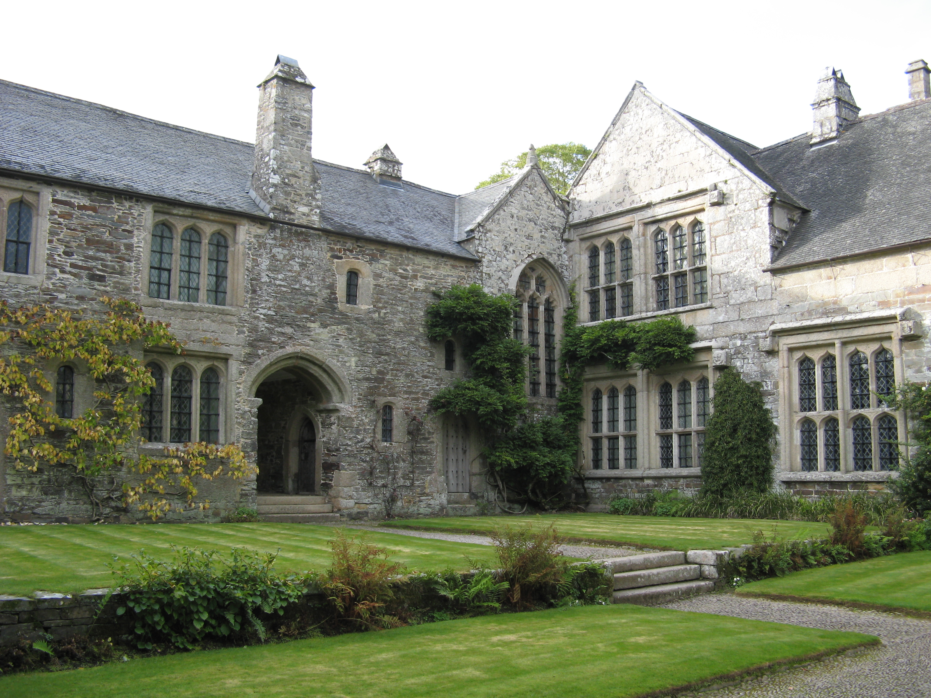
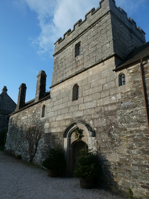
Cotehele

Cotehele (Cornish: Kosheyl) is a medieval house with Tudor additions, situated in the parish of Calstock in the east of Cornwall, England, and now belonging...
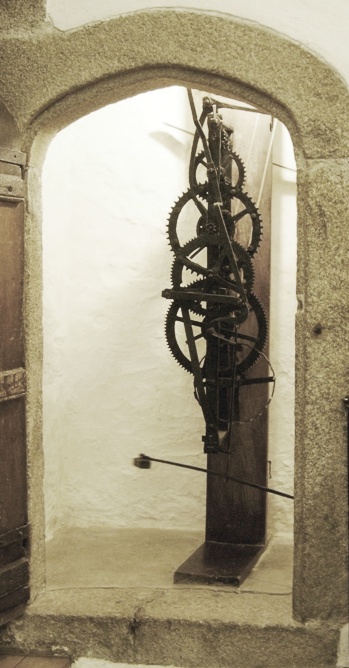
Cotehele clock

The Cotehele clock is situated at Cotehele House, Calstock, Cornwall. It is the earliest turret clock in the United Kingdom still working in an unaltered...

Tamar Valley AONB

Tamar Valley Area of Outstanding Natural Beauty or Tamar Valley AONB is a legally designated Area of Outstanding Natural Beauty in Devon and Cornwall in...

Nearby Amenities

Located within 500m of 50.488937,-4.2259294
Source: PGS
Lat/Long: 50.4902789/-4.2241638
Source: PGS
Lat/Long: 50.4911929/-4.2230413
Source: PGS
Lat/Long: 50.4913092/-4.2229329
Source: PGS
Lat/Long: 50.4914543/-4.2226623
Source: PGS
Lat/Long: 50.4891788/-4.2232784
Source: PGS
Lat/Long: 50.4886491/-4.222875
Source: PGS
Lat/Long: 50.4881958/-4.2225493
Source: PGS
Lat/Long: 50.4867433/-4.2214159
Source: PGS
Lat/Long: 50.4865685/-4.2211498
Source: PGS
Lat/Long: 50.4864611/-4.2209384
Source: PGS
Lat/Long: 50.4862025/-4.2205606
Bus Stop
Cotehele Quay
Bus: yes
Naptan AtcoCode: 0800COA10673
Naptan Bearing: N
Naptan CommonName: Cotehele Quay
Naptan NaptanCode: corgadja
Naptan Street: Unclassified
Naptan Verified: no
Public Transport: platform
Source: naptan_import
Lat/Long: 50.4907755/-4.2241149
Cotehele Quay
Naptan AtcoCode: 0800COA15243
Naptan Bearing: N
Naptan BusStopType: CUS
Naptan CommonName: Cotehele Quay
Naptan NaptanCode: corgdgtg
Naptan Street: Unclassified
Naptan Verified: no
Lat/Long: 50.4907498/-4.2240432
Cafe
The Edgcumbe
Lat/Long: 50.4915296/-4.2237592
Cotehele Quay Discovery Centre
Museum: local_history
Tourism: museum
Website: https://www.nationaltrust.org.uk/cotehele/features/cotehele-quay
Lat/Long: 50.4909494/-4.2237485
Post Box
Brand: Royal Mail
Brand Wikidata: Q638098
Brand Wikipedia: en:Royal Mail
Collection Times: Mo-Fr 15:30; Sa 09:00; Su off
Drive Through: no
Operator: Royal Mail
Operator Wikidata: Q638098
Post Box Design: type_b
Post Box Mounting: stone_wall
Post Box Type: wall
Ref: PL12 461
Royal Cypher: EIIR
Royal Cypher Wikidata: Q33102113
Source: survey;streetlevel imagery;aerial imagery
Lat/Long: 50.4907859/-4.2240975
Bench
Lat/Long: 50.4910244/-4.2233021
Bench
Lat/Long: 50.490678/-4.2236642
Toilets
Lat/Long: 50.4913111/-4.2237769
The Shamrock
Tourism: attraction
Lat/Long: 50.4914464/-4.2234023
Bench
Lat/Long: 50.4912741/-4.2235029
Bench
Lat/Long: 50.4915267/-4.2231113
Bench
Lat/Long: 50.4911922/-4.2234949
Bench
Lat/Long: 50.4914874/-4.2230255
Bench
Lat/Long: 50.4911035/-4.2234788
Lime Kilns
Historic: ruins
Lat/Long: 50.4895574/-4.2249057
Lime Kilns
Historic: ruins
Lat/Long: 50.4916632/-4.2237229
Barrier: cycle_barrier
Lat/Long: 50.4909533/-4.2253697
Lime Kilns
Historic: ruins
Lat/Long: 50.4910489/-4.2242217
Cotehele Quay
Place: locality
Lat/Long: 50.4912024/-4.2232337
Shop: kiosk
Lat/Long: 50.4912299/-4.2237162
Barrier: kissing_gate
Lat/Long: 50.4877008/-4.2258284
Barrier: stile
Stile: squeezer
Lat/Long: 50.4909626/-4.2253313
The data included in this document is from www.openstreetmap.org. The data is made available under ODbL.

Have you been to Bohetherick Wood?

Leave your review of Bohetherick Wood below (or comments, questions and feedback).