Ampleforth

Settlement in Yorkshire Ryedale

England

Ampleforth

Ampleforth Abbey and College Viewed from the rear
Ampleforth Abbey and College Credit: Ken Crosby

Ampleforth is a picturesque village located in the Ryedale district of North Yorkshire, England. Nestled within the stunning Howardian Hills, this small village is known for its idyllic countryside setting and charming atmosphere.

The village is home to the renowned Ampleforth College, a prestigious Roman Catholic boarding school that was established in 1802. The college's stunning buildings and extensive grounds add to the beauty of the area, making it a popular destination for visitors.

Ampleforth Abbey, a Benedictine monastery, is another prominent feature of the village. The abbey dates back to the 19th century and boasts impressive architecture, including a magnificent Gothic church. Visitors can enjoy guided tours of the abbey, explore its tranquil gardens, and even witness the monks at prayer.

The surrounding countryside provides ample opportunities for outdoor activities, such as hiking, cycling, and horse riding. The Howardian Hills Area of Outstanding Natural Beauty offers breathtaking views, with rolling hills, lush woodlands, and meandering streams.

In terms of amenities, Ampleforth offers a range of facilities including a village shop, a post office, and a pub. The village also hosts various events throughout the year, such as the Ampleforth Village Show and the Ampleforth Abbey Beer Festival.

Overall, Ampleforth is a charming village that offers a delightful mix of history, natural beauty, and a vibrant community, making it a must-visit destination for those seeking a peaceful retreat in the heart of Yorkshire.

If you have any feedback on the listing, please let us know in the comments section below.

Ampleforth Images

Images are sourced within 2km of 54.201039/-1.107827 or Grid Reference SE5878. Thanks to Geograph Open Source API. All images are credited.
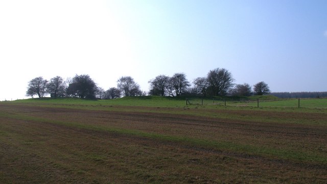
Ampleforth Abbey and College Viewed from the rear
Ampleforth Abbey and College
Viewed from the rear
Ampleforth College Rugby Pitches
Ampleforth College Tennis Courts
Savill Field 2002 - Ampleforth College sports facilities
Ampleforth College Cricket Scoreboard
Track at Windmill Farm The track runs almost dead straight until it meets a public footpath that drops into Ampleforth. However, there is no indication that this is a right of way.
Track at Windmill Farm
The track runs almost dead straight until it meets a public footpath that drops into Ampleforth. However, there is no indication that this is a right of way.
Track into Dropping Gill Forest track that follows the edge of a small valley.
Track into Dropping Gill
Forest track that follows the edge of a small valley.
Studfold Ring Seen from the east, this feature appears as a low bank with small trees on and within the earthwork.  One would assume that this is a prehistoric site, but it appears to be largely medieval and would have been used as some sort of corral for horses.
Studfold Ring
Seen from the east, this feature appears as a low bank with small trees on and within the earthwork. One would assume that this is a prehistoric site, but it appears to be largely medieval and would have been used as some sort of corral for horses.
Studfold Ring - outer bank The map shows this earthwork as a circle, but the shape is more of a rectangle with rounded off corners [perhaps based on the design of the Austin Allegro steering wheel?]. Not a defensive site, due to the flat surroundings and a ditch inside the outer bank, but actually a medieval horse enclosure.
Studfold Ring - outer bank
The map shows this earthwork as a circle, but the shape is more of a rectangle with rounded off corners [perhaps based on the design of the Austin Allegro steering wheel?]. Not a defensive site, due to the flat surroundings and a ditch inside the outer bank, but actually a medieval horse enclosure.
Inside Studfold Ring Looking across the flat inner area of the ring with the ditch and bank visible around the perimeter. Studford Farm visible beyond.
Note that the feature is shown as Studford Ring on the 1:50000 map and is also known as Stotfold Ring. The term 'stud' associates it with horses, as this was a medieval horse enclosure.
Inside Studfold Ring
Looking across the flat inner area of the ring with the ditch and bank visible around the perimeter. Studford Farm visible beyond. Note that the feature is shown as Studford Ring on the 1:50000 map and is also known as Stotfold Ring. The term 'stud' associates it with horses, as this was a medieval horse enclosure.
A wind turbine at Thorpe Grange
A sign for the Howardian Hill
A path leading to Ampleforth
Ampleforth Abbey, 2011 <span class="nowrap"><a title="http://www.abbey.ampleforth.org.uk/" rel="nofollow ugc noopener" href="http://www.abbey.ampleforth.org.uk/">Link</a><img style="margin-left:2px;" alt="External link" title="External link - shift click to open in new window" src="https://s1.geograph.org.uk/img/external.png" width="10" height="10"/></span>
Ampleforth Abbey, 2011
Monastery West Wing, Ampleforth Abbey The largest Benedictine community in Britain.
Monastery West Wing, Ampleforth Abbey
The largest Benedictine community in Britain.
Monastery, Ampleforth Abbey, autumn 2011 The largest Benedictine community in Britain.
Monastery, Ampleforth Abbey, autumn 2011
The largest Benedictine community in Britain.
Immaculate cricket pitch, Ampleforth Ampleforth hosts an annual cricket festival.
Immaculate cricket pitch, Ampleforth
Ampleforth hosts an annual cricket festival.
View to Ampleforth Abbey The abbey and college are beautifully situated in the Howardian Hills. The Ampleforth Abbey Estate covers over 2000 acres and encompasses grassland, farmland and woodland and is located in an AONB.
View to Ampleforth Abbey
The abbey and college are beautifully situated in the Howardian Hills. The Ampleforth Abbey Estate covers over 2000 acres and encompasses grassland, farmland and woodland and is located in an AONB.
Show me another place!

Ampleforth is located at Grid Ref: SE5878 (Lat: 54.201039, Lng: -1.107827)

Division: North Riding

Administrative County: North Yorkshire

District: Ryedale

Police Authority: North Yorkshire

What 3 Words

///behalf.withdraws.teacher. Near Helmsley, North Yorkshire

Nearby Locations

Ampleforth

Related Wikis

Ampleforth

Ampleforth is a village and civil parish in North Yorkshire, England, 20 miles (32 km) north of York. The village is situated on the edge of the North...

Ampleforth Abbey

Ampleforth Abbey is a monastery of Benedictine monks a mile to the east of Ampleforth, North Yorkshire, England, part of the English Benedictine Congregation...

Ampleforth College

Ampleforth College is a co-educational fee-charging boarding and day school in the English public school tradition. It opened in 1802 as a boys' school...

Ampleforth railway station

Ampleforth railway station, served the village of Ampleforth, in the Northern English county of North Yorkshire. It was located on a line which ran from...

Stanbrook Abbey

Stanbrook Abbey is a Catholic contemplative Benedictine Monastery with the status of an abbey, located at Wass, North Yorkshire, England. The community...

Wass, North Yorkshire

Wass is a village in the civil parish of Byland with Wass, in North Yorkshire, England, in the North York Moors National Park. A short distance from the...

Byland with Wass

Byland with Wass is a civil parish in the Ryedale district of North Yorkshire, England. According to the 2001 census it had a population of 120, increasing...

Byland Abbey

Byland Abbey is a ruined abbey and a small village in the Ryedale district of North Yorkshire, England, in the North York Moors National Park. == History... ==

Nearby Amenities

Located within 500m of 54.201039,-1.107827
Pub
White Swan
Addr City: York
Addr Postcode: YO62 4DA
Addr Suburb: Ampleforth
Floor Material: carpet
Food: yes
Outdoor Seating: yes
Real Ale: 3 beers, may vary
Wheelchair: yes
Wheelchair Description: Ramp up from car park, then flat
Lat/Long: 54.2009303/-1.107269
Pub
White Horse Inn
Accommodation: yes
Addr City: York
Addr Postcode: YO62 4DX
Addr Street: West End
Addr Suburb: Ampleforth
Floor Material: stone;rough_wood
Food: yes
Note: Closed Monday
Outdoor Seating: yes
Parking: yes
Real Ale: Theakstons Best+1, may vary
Wheelchair: limited
Wheelchair Description: Some amount of small steps and winding corridors from every direction. Outside seating area level with car park.
Lat/Long: 54.2010229/-1.1107587
Post Office
Ampleforth Post Office
Addr City: York
Addr Country: GB
Addr Postcode: YO62 4DX
Addr Street: West End
Addr Suburb: Ampleforth
Brand: Post Office
Brand Wikidata: Q1783168
Contact Website: https://www.postoffice.co.uk/branch-finder/1553496/ampleforth
Opening Hours: Mo-Fr 09:00-17:30; Sa 09:00-12:30
Ref Pol Id: 3227
Lat/Long: 54.2012066/-1.107595
Bus Stop
Naptan AtcoCode: 3200YNA91206
Naptan NaptanCode: 32091206
Lat/Long: 54.2010044/-1.1075647
Passing Place
Lat/Long: 54.2016348/-1.1098258
Telephone
Booth: K6
Covered: booth
Lat/Long: 54.2009461/-1.1094898
Post Box
Post Box Type: pillar
Ref: YO62 119
Royal Cypher: EIIR
Royal Cypher Wikidata: Q33102113
Lat/Long: 54.201103/-1.1075723
Bus Stop
Naptan AtcoCode: 3200YNA91207
Naptan NaptanCode: 32091207
Lat/Long: 54.2010779/-1.1075631
Cafe
Hearts Of Ampleforth
Cuisine: coffee_shop
Lat/Long: 54.2009239/-1.108593
Barrier: stile
Step Count: 2
Stile: stepover
Lat/Long: 54.2035759/-1.1073132
Barrier: stile
Dog Gate: yes
Step Count: 2
Stile: stepover
Lat/Long: 54.2035196/-1.1093188
Barrier: stile
Dog Gate: yes
Step Count: 2
Stile: stepover
Lat/Long: 54.2028636/-1.1112881
Barrier: stile
Step Count: 2
Stile: stepover
Lat/Long: 54.2033873/-1.1097128
Barrier: stile
Step Count: 3
Stile: stepover
Lat/Long: 54.2031994/-1.1105621
Defibrillator
Defibrillator Location: outside Ampleforth Village Store, West End, Ampleforth, YO62 4DX - to left of entrance
Emergency: defibrillator
Indoor: no
Lat/Long: 54.2011279/-1.107647
Entrance: yes
Lat/Long: 54.2011299/-1.1076173
Board Type: notice
Information: board
Tourism: information
Lat/Long: 54.2009256/-1.1078919
Bench
Lat/Long: 54.2009461/-1.1095952
Post Box
Collection Times: Mo-Fr 09:00; Sa 07:00
Post Box Type: lamp
Ref: YO62 517
Royal Cypher: EIIR
Royal Cypher Wikidata: Q33102113
Lat/Long: 54.1974908/-1.105996
Barrier: stile
Step Count: 1
Stile: stepover
Lat/Long: 54.1998165/-1.1135114
Barrier: kissing_gate
Lat/Long: 54.1985217/-1.1123902
Barrier: stile
Dog Gate: yes
Step Count: 1
Stile: stepover
Lat/Long: 54.2002333/-1.1137692
Barrier: stile
Step Count: 1
Stile: stepover
Lat/Long: 54.1989347/-1.1126299
Barrier: stile
Step Count: 1
Stile: stepover
Lat/Long: 54.1993244/-1.1130671
Information: guidepost
Tourism: information
Lat/Long: 54.2010984/-1.1078904
The data included in this document is from www.openstreetmap.org. The data is made available under ODbL.

Have you been to Ampleforth?

Leave your review of Ampleforth below (or comments, questions and feedback).