Borlase Wood

Wood, Forest in Cornwall

England

Borlase Wood

Old Kea Church Tower
Old Kea Church Tower Credit: Paul Barnett

Borlase Wood is a picturesque woodland located in Cornwall, England. Stretching over an area of approximately 50 acres, it is nestled in the heart of the county, near the village of Ludgvan. The woodland is named after the renowned Cornish historian William Borlase, who extensively studied the natural history and archaeology of the region.

Borlase Wood boasts a rich biodiversity, with a variety of tree species such as oak, beech, and chestnut, among others. The towering trees create a dense canopy that provides a haven for numerous bird species, including woodpeckers, thrushes, and owls. The forest floor is adorned with a carpet of wildflowers during the spring and summer months, adding to the woodland's natural beauty.

The wood is crisscrossed by several walking trails, allowing visitors to explore its enchanting surroundings. These paths wind through the ancient trees, offering glimpses of wildlife and providing a tranquil escape from the hustle and bustle of everyday life. Nature enthusiasts can enjoy birdwatching, photography, or simply immersing themselves in the peaceful ambiance.

Borlase Wood is also home to a diverse range of wildlife, including deer, foxes, and badgers. The presence of these animals adds to the sense of wilderness and natural harmony within the woodland. Additionally, the area is known for its historical significance, with remnants of ancient settlements and archaeological sites scattered throughout the forest.

Overall, Borlase Wood is a captivating destination for nature lovers and history enthusiasts alike. With its serene atmosphere, diverse flora and fauna, and intriguing past, it remains a cherished gem in the Cornish countryside.

If you have any feedback on the listing, please let us know in the comments section below.

Borlase Wood Images

Images are sourced within 2km of 50.222497/-5.0069575 or Grid Reference SW8540. Thanks to Geograph Open Source API. All images are credited.

Old Kea Church Tower
Tower at Trelissick Gardens The tower in the grounds of the gardens at Trelissick.
Tower at Trelissick Gardens
The tower in the grounds of the gardens at Trelissick.
Peegee hydrangea at Trelissick Gardens A lovely flowering Peegee hydrangea at Trelissick Gardens in front of the house.
Peegee hydrangea at Trelissick Gardens
A lovely flowering Peegee hydrangea at Trelissick Gardens in front of the house.
Tower at Trelissick Gardens The tower in the grounds of the gardens at Trelissick.
Tower at Trelissick Gardens
The tower in the grounds of the gardens at Trelissick.
King Harry Ferry
King Harry Ferry
Trelissick House
Trelissick House
Leaving the King Harry ferry
Footbridge over the B3289 at Trelissick
Terrace in front of Trelissick House With my wife enjoying the view.
Terrace in front of Trelissick House
With my wife enjoying the view.
Father Christmas on the King Harry Ferry There was another Father Christmas sitting on the west bank looking out over the ferry and estuary.
Father Christmas on the King Harry Ferry
There was another Father Christmas sitting on the west bank looking out over the ferry and estuary.
Roundwood Quay This has been a trading site since at least the Iron Age but the present structure is circa late C18, when it was used to ship copper and tin ore from Chacewater and North Downs mines. Vessels of up to 300 tons were able to moor alongside at the lowest tides. Large ships are often moored in this stretch of the river whilst laid up, as is the Madeira registered car carrier, 'Autopremier', which can be seen here. The structure is Grade II Listed <span class="nowrap"><a title="http://www.imagesofengland.org.uk/Details/Default.aspx?id=63305&mode=adv" rel="nofollow ugc noopener" href="http://www.imagesofengland.org.uk/Details/Default.aspx?id=63305&mode=adv">Link</a><img style="margin-left:2px;" alt="External link" title="External link - shift click to open in new window" src="https://s1.geograph.org.uk/img/external.png" width="10" height="10"/></span>.
Roundwood Quay
This has been a trading site since at least the Iron Age but the present structure is circa late C18, when it was used to ship copper and tin ore from Chacewater and North Downs mines. Vessels of up to 300 tons were able to moor alongside at the lowest tides. Large ships are often moored in this stretch of the river whilst laid up, as is the Madeira registered car carrier, 'Autopremier', which can be seen here. The structure is Grade II Listed LinkExternal link.
Loading bays at Roundwood Quay This peaceful location was a busy quay in the late C18 when ships came alongside to load copper and tin ore from the mining areas inland.
Loading bays at Roundwood Quay
This peaceful location was a busy quay in the late C18 when ships came alongside to load copper and tin ore from the mining areas inland.
The mouth of Cowlands Creek The creek joins the River Fal just to the right of this picture.  On the left are <a href="https://www.geograph.org.uk/photo/2317026">SW8340 : Loading bays at Roundwood Quay</a>.
The mouth of Cowlands Creek
The creek joins the River Fal just to the right of this picture. On the left are SW8340 : Loading bays at Roundwood Quay.
The junction of Cowlands Creek and the River Fal Looking across to Smuggler's Cottage at Tolverne in square <a href="https://www.geograph.org.uk/gridref/SW8340">SW8340</a>. Lamouth Creek also joins the Fal at this point.
The junction of Cowlands Creek and the River Fal
Looking across to Smuggler's Cottage at Tolverne in square SW8340. Lamouth Creek also joins the Fal at this point.
Earthbank at Roundwood Fort This very well preserved large fort is on a commanding position on a promontory between Cowlands Creek and Lamouth Creek on the west side of the River Fal.
Earthbank at Roundwood Fort
This very well preserved large fort is on a commanding position on a promontory between Cowlands Creek and Lamouth Creek on the west side of the River Fal.
The car carrier 'Autopremier' moored in the River Fal Seen from the Trelissick woodland walk. For another view see <a href="https://www.geograph.org.uk/photo/2317017">SW8340 : Roundwood Quay</a>.
The car carrier 'Autopremier' moored in the River Fal
Seen from the Trelissick woodland walk. For another view see SW8340 : Roundwood Quay.
Show me another place!

Borlase Wood is located at Grid Ref: SW8540 (Lat: 50.222497, Lng: -5.0069575)

Unitary Authority: Cornwall

Police Authority: Devon and Cornwall

What 3 Words

///momentous.quench.drove. Near Portscatho, Cornwall

Related Wikis

Tolverne Cottage

Tolverne Cottage, also known as Smugglers Cottage, is a small Grade II-listed cottage in south Cornwall, England. It is situated within the civil parish...
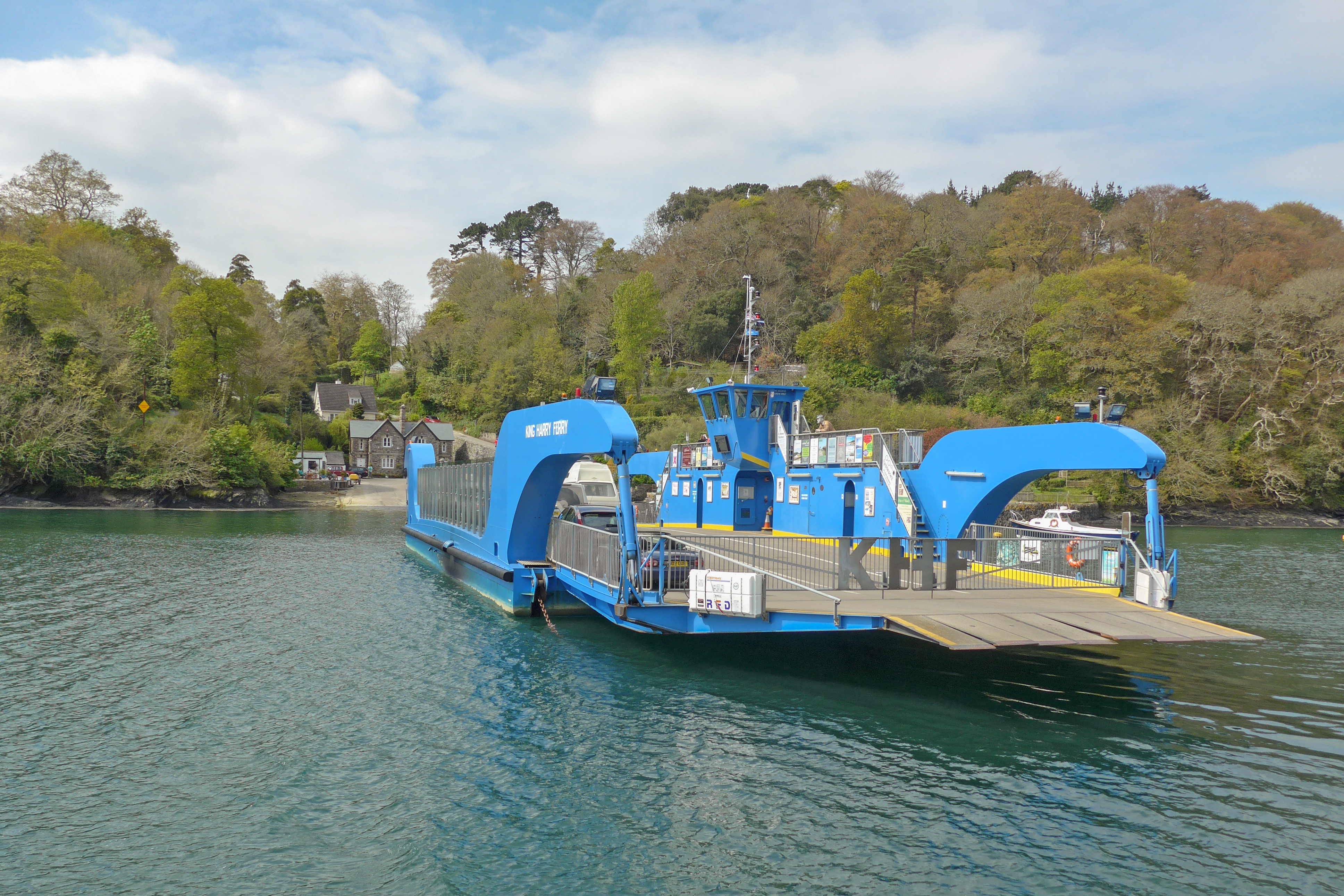
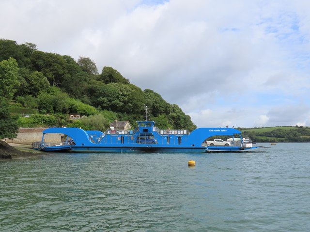
King Harry Ferry

The King Harry Ferry Bridge is a vehicular chain ferry which crosses the Carrick Roads reach of the estuary of the River Fal in Cornwall, England, UK...

Philleigh

Philleigh (Cornish: Eglosros) is a civil parish and village in Cornwall, England, in the United Kingdom; one of the four in the Roseland Peninsula. Philleigh...

St Michael Penkevil

St Michael Penkivel (Cornish: Pennkevyl), sometimes spelt St Michael Penkevil, is a civil parish and village in Cornwall, England, United Kingdom. It...

Nearby Amenities

Located within 500m of 50.222497,-5.0069575
Source: PGS
Lat/Long: 50.2267176/-5.0045331
Source: PGS
Lat/Long: 50.2261747/-5.0041688
Source: PGS
Lat/Long: 50.2234203/-5.0040272
Source: PGS
Lat/Long: 50.2232733/-5.0047264
Source: PGS
Lat/Long: 50.2236493/-5.0060609
Source: PGS
Lat/Long: 50.2241163/-5.0060023
Source: PGS
Lat/Long: 50.2248373/-5.0069389
Source: PGS
Lat/Long: 50.2268725/-5.0085357
Source: PGS
Lat/Long: 50.225707/-5.0115787
Source: PGS
Lat/Long: 50.2257162/-5.0117328
The data included in this document is from www.openstreetmap.org. The data is made available under ODbL.

Have you been to Borlase Wood?

Leave your review of Borlase Wood below (or comments, questions and feedback).