Barnclose Plantation

Wood, Forest in Cornwall

England

Barnclose Plantation

Farmland, St Michael Penkevil Arable land beside the road descending towards Lamorran. A building at Trewonnal can be seen in the background.
Farmland, St Michael Penkevil Credit: Andrew Smith

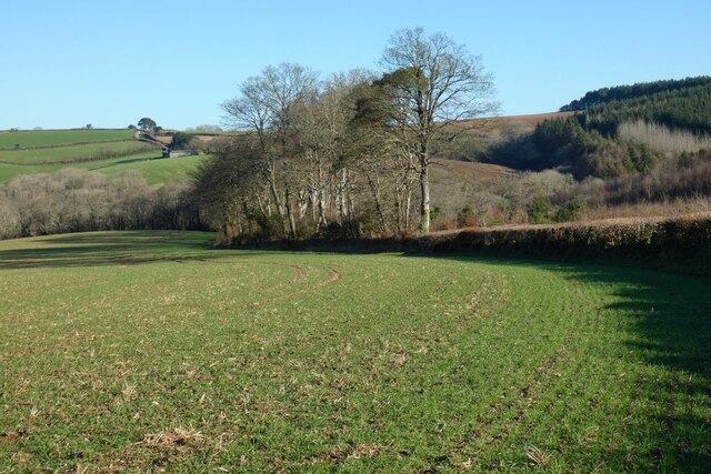
Barnclose Plantation is a picturesque woodland area located in Cornwall, England. This enchanting plantation covers a vast expanse of approximately 200 acres, making it a popular destination for nature enthusiasts and outdoor lovers.

The main feature of Barnclose Plantation is its dense and diverse forest. The woodland is composed of a variety of tree species, including oak, beech, and pine, creating a harmonious blend of colors throughout the seasons. This rich biodiversity supports a plethora of wildlife, making it a haven for birdwatchers and animal lovers. Visitors may spot common woodland birds such as thrushes, woodpeckers, and robins, as well as mammals like deer and foxes.

The plantation offers several well-maintained trails, providing visitors with the opportunity to explore the woodland at their own pace. These paths wind through the ancient trees, allowing visitors to immerse themselves in the tranquility of nature. Along the way, informative signs provide insights into the history and ecology of the plantation, enhancing the overall experience.

Barnclose Plantation also boasts a small picnic area, providing the perfect spot for visitors to relax and enjoy their surroundings. The plantation is a popular destination for families, who can enjoy a leisurely picnic amidst the beauty of the woodland.

Overall, Barnclose Plantation is a captivating destination that showcases the natural beauty of Cornwall. With its lush forest, diverse wildlife, and well-maintained trails, it offers a serene and immersive experience for all nature enthusiasts.

If you have any feedback on the listing, please let us know in the comments section below.

Barnclose Plantation Images

Images are sourced within 2km of 50.233926/-5.0112813 or Grid Reference SW8541. Thanks to Geograph Open Source API. All images are credited.

Farmland, St Michael Penkevil Arable land beside the road descending towards Lamorran. A building at Trewonnal can be seen in the background.
Farmland, St Michael Penkevil
Arable land beside the road descending towards Lamorran. A building at Trewonnal can be seen in the background.
Pasture, St Clement Beside the direct footpath between the village and Malpas.
Pasture, St Clement
Beside the direct footpath between the village and Malpas.
Old Kea Church Tower
Roundwood Quay This has been a trading site since at least the Iron Age but the present structure is circa late C18, when it was used to ship copper and tin ore from Chacewater and North Downs mines. Vessels of up to 300 tons were able to moor alongside at the lowest tides. Large ships are often moored in this stretch of the river whilst laid up, as is the Madeira registered car carrier, 'Autopremier', which can be seen here. The structure is Grade II Listed <span class="nowrap"><a title="http://www.imagesofengland.org.uk/Details/Default.aspx?id=63305&mode=adv" rel="nofollow ugc noopener" href="http://www.imagesofengland.org.uk/Details/Default.aspx?id=63305&mode=adv">Link</a><img style="margin-left:2px;" alt="External link" title="External link - shift click to open in new window" src="https://s1.geograph.org.uk/img/external.png" width="10" height="10"/></span>.
Roundwood Quay
This has been a trading site since at least the Iron Age but the present structure is circa late C18, when it was used to ship copper and tin ore from Chacewater and North Downs mines. Vessels of up to 300 tons were able to moor alongside at the lowest tides. Large ships are often moored in this stretch of the river whilst laid up, as is the Madeira registered car carrier, 'Autopremier', which can be seen here. The structure is Grade II Listed LinkExternal link.
Loading bays at Roundwood Quay This peaceful location was a busy quay in the late C18 when ships came alongside to load copper and tin ore from the mining areas inland.
Loading bays at Roundwood Quay
This peaceful location was a busy quay in the late C18 when ships came alongside to load copper and tin ore from the mining areas inland.
The mouth of Cowlands Creek The creek joins the River Fal just to the right of this picture.  On the left are <a href="https://www.geograph.org.uk/photo/2317026">SW8340 : Loading bays at Roundwood Quay</a>.
The mouth of Cowlands Creek
The creek joins the River Fal just to the right of this picture. On the left are SW8340 : Loading bays at Roundwood Quay.
The junction of Cowlands Creek and the River Fal Looking across to Smuggler's Cottage at Tolverne in square <a href="https://www.geograph.org.uk/gridref/SW8340">SW8340</a>. Lamouth Creek also joins the Fal at this point.
The junction of Cowlands Creek and the River Fal
Looking across to Smuggler's Cottage at Tolverne in square SW8340. Lamouth Creek also joins the Fal at this point.
Earthbank at Roundwood Fort This very well preserved large fort is on a commanding position on a promontory between Cowlands Creek and Lamouth Creek on the west side of the River Fal.
Earthbank at Roundwood Fort
This very well preserved large fort is on a commanding position on a promontory between Cowlands Creek and Lamouth Creek on the west side of the River Fal.
The car carrier 'Autopremier' moored in the River Fal Seen from the Trelissick woodland walk. For another view see <a href="https://www.geograph.org.uk/photo/2317017">SW8340 : Roundwood Quay</a>.
The car carrier 'Autopremier' moored in the River Fal
Seen from the Trelissick woodland walk. For another view see SW8340 : Roundwood Quay.
Smugglers Cottage Tolverne Cottage is known locally as "Smugglers Cottage" and is a popular stop off on the River Fal.
Smugglers Cottage
Tolverne Cottage is known locally as "Smugglers Cottage" and is a popular stop off on the River Fal.
Trelissick Gardens running down to the Fal As viewed from the river.
Trelissick Gardens running down to the Fal
As viewed from the river.
Tregothnan See <a href="https://www.geograph.org.uk/photo/2671594">SW8541 : Tregothnan</a>.  Viewed from Trelissick Gardens across the River Fal, with laid up shipping in the foreground (see <a href="https://www.geograph.org.uk/photo/2671550">SW8439 : Shipping on the River Fal</a>).
Tregothnan
See SW8541 : Tregothnan. Viewed from Trelissick Gardens across the River Fal, with laid up shipping in the foreground (see SW8439 : Shipping on the River Fal).
Tregothnan The family seat of the Boscowans, Viscount Falmouth.  The house originally dates from 1652, but was rebuilt in the 1820a to a design of William Wilkins, architect also of the National Gallery and buildings at both King's College and Downing College, Cambridge.  Seen here from Trelissick, across the River Fal.  Grade I listed - for listing particulars, see <span class="nowrap"><a title="www.historicengland.org.uk/listing/the-list/list-entry/1141069" rel="nofollow ugc noopener" href="http://www.historicengland.org.uk/listing/the-list/list-entry/1141069">Link</a><img style="margin-left:2px;" alt="External link" title="External link - shift click to open in new window" src="https://s1.geograph.org.uk/img/external.png" width="10" height="10"/></span>.
Tregothnan
The family seat of the Boscowans, Viscount Falmouth. The house originally dates from 1652, but was rebuilt in the 1820a to a design of William Wilkins, architect also of the National Gallery and buildings at both King's College and Downing College, Cambridge. Seen here from Trelissick, across the River Fal. Grade I listed - for listing particulars, see LinkExternal link.
'Summer Bay' laid up in the River Fal A reefer of the NYKCool line in 'dry' lay-up, probably awaiting scrapping.
'Summer Bay' laid up in the River Fal
A reefer of the NYKCool line in 'dry' lay-up, probably awaiting scrapping.
Mouth of Tresillian River
Riverside house at Malpas
Show me another place!

Barnclose Plantation is located at Grid Ref: SW8541 (Lat: 50.233926, Lng: -5.0112813)

Unitary Authority: Cornwall

Police Authority: Devon and Cornwall

What 3 Words

///cheerily.coiling.negotiators. Near Truro, Cornwall

Related Wikis

St Michael Penkevil

St Michael Penkivel (Cornish: Pennkevyl), sometimes spelt St Michael Penkevil, is a civil parish and village in Cornwall, England, United Kingdom. It...

Diocese of Truro

The Diocese of Truro (established 1876) is a Church of England diocese in the Province of Canterbury which covers Cornwall, the Isles of Scilly and a small...

Kea Monastery

Kea Monastery was a monastery at Kea in Cornwall, UK, of which little is known. "The mysterious land-owning monastery of St Cheus mentioned in Domesday...

Old Kea

Old Kea (Cornish: Lanndege) is a hamlet in Cornwall, England, United Kingdom. It is situated on the west bank of the Truro River approximately two miles...

Nearby Amenities

Located within 500m of 50.233926,-5.0112813
Source: PGS
Lat/Long: 50.2376696/-5.0139896
Source: PGS
Lat/Long: 50.2370249/-5.0132792
Source: PGS
Lat/Long: 50.2368984/-5.0146459
Source: PGS
Lat/Long: 50.2363094/-5.0154878
Source: PGS
Lat/Long: 50.2355708/-5.0158472
Source: PGS
Lat/Long: 50.2351641/-5.0159674
Source: PGS
Lat/Long: 50.2337643/-5.016398
Source: PGS
Lat/Long: 50.2330907/-5.0162953
Bus Stop
Tregothnan House
Bus: yes
Naptan AtcoCode: 0800COC30050
Naptan Bearing: NE
Naptan CommonName: Tregothnan House
Naptan NaptanCode: cordajmt
Naptan Street: Estate Road
Naptan Verified: no
Public Transport: platform
Source: naptan_import
Lat/Long: 50.2356901/-5.0070706
Source: PGS
Lat/Long: 50.2370833/-5.0136312
The data included in this document is from www.openstreetmap.org. The data is made available under ODbL.

Have you been to Barnclose Plantation?

Leave your review of Barnclose Plantation below (or comments, questions and feedback).