Atton Wood

Wood, Forest in Berwickshire

Scotland

Atton Wood

Howpark The rocky dean of the Howpark Burn, just downstream of the farm.
Howpark Credit: Richard Webb

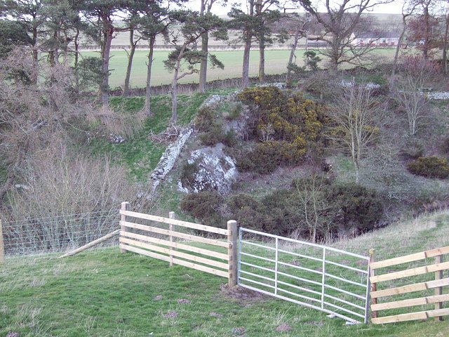
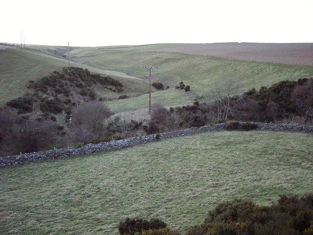
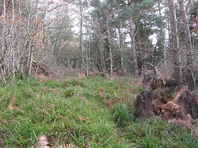
Atton Wood is a picturesque forest located in the county of Berwickshire, Scotland. Covering an area of approximately 100 hectares, it is a significant natural landmark in the region. The woodland is predominantly composed of a mix of broadleaf and coniferous trees, creating a diverse and enchanting landscape.

Atton Wood offers a haven for wildlife, providing a habitat for a wide range of species. Visitors can often spot deer, foxes, badgers, and a variety of bird species, making it a popular destination for nature enthusiasts and birdwatchers. The forest is also home to a number of rare and protected species, adding to its ecological importance.

The wood is well-maintained and features several well-marked walking trails, making it an ideal location for leisurely walks and hikes. The paths wind through the forest, offering visitors the chance to explore its beauty while enjoying the peaceful ambiance. Along the way, there are several designated picnic areas, allowing visitors to take a break and enjoy a meal surrounded by nature.

Atton Wood is easily accessible, with ample parking facilities available nearby. It is open to the public throughout the year, providing a tranquil escape from the hustle and bustle of everyday life. Whether it's a leisurely stroll, a family picnic, or a birdwatching expedition, Atton Wood offers a delightful experience for all who visit.

If you have any feedback on the listing, please let us know in the comments section below.

Atton Wood Images

Images are sourced within 2km of 55.878013/-2.2702819 or Grid Reference NT8365. Thanks to Geograph Open Source API. All images are credited.

Howpark The rocky dean of the Howpark Burn, just downstream of the farm.
Howpark
The rocky dean of the Howpark Burn, just downstream of the farm.
Draining Penmanshiel Moor. A "nameless" cleuch draining the southern slopes of Penmanshiel Moor. Taken from the Howpark Road.
Draining Penmanshiel Moor.
A "nameless" cleuch draining the southern slopes of Penmanshiel Moor. Taken from the Howpark Road.
Cedar Cafe. Cafe popular with truckers. Situated at the foot of the Howpark Road, on an old cut off loop of the A1.
Cedar Cafe.
Cafe popular with truckers. Situated at the foot of the Howpark Road, on an old cut off loop of the A1.
Old A1 Redundant loop of the A1, used as an overnight parking spot for lorries, near the Cedar Cafe.
Old A1
Redundant loop of the A1, used as an overnight parking spot for lorries, near the Cedar Cafe.
Brockholes Hill Lambing time in the Lammermuirs.
Brockholes Hill
Lambing time in the Lammermuirs.
Brockholes Farm Cottages Small hamlet of cottages, next to Brockhole Farm near Coldingham.
Brockholes Farm Cottages
Small hamlet of cottages, next to Brockhole Farm near Coldingham.
Renton Farm near Grantshouse. Sheep and cattle graze the very green pasture on a shelf above the A1.
Renton
Farm near Grantshouse. Sheep and cattle graze the very green pasture on a shelf above the A1.
Atton Dean Oakwoods above the A1 in the Lammermuir Hills. The woods rise steeply above an old cut off loop of the road, while the modern route passes to the west.
Atton Dean
Oakwoods above the A1 in the Lammermuir Hills. The woods rise steeply above an old cut off loop of the road, while the modern route passes to the west.
Green Wood Not so green on the day of the Winter Solstice. This is a small Forestry Commission property above Houndwood. The maps are wrong here, a road now runs up through the wood from Houndwood, and the old lane up from the A1 has been closed.
Green Wood
Not so green on the day of the Winter Solstice. This is a small Forestry Commission property above Houndwood. The maps are wrong here, a road now runs up through the wood from Houndwood, and the old lane up from the A1 has been closed.
Houndwood Postbox and local resident.
Houndwood
Postbox and local resident.
A1, Houndwood Underpass and the new section of dual carriageway bypassing Houndwood.
A1, Houndwood
Underpass and the new section of dual carriageway bypassing Houndwood.
Green Wood Forestry Commission woodland above Houndwood. A pleasing mix of trees and dense undergrowth. Full of finches living off the goose and peacock food in the village below.
Green Wood
Forestry Commission woodland above Houndwood. A pleasing mix of trees and dense undergrowth. Full of finches living off the goose and peacock food in the village below.
Atton Dean A cut off loop of the A1 with houses that are now a little quieter.
Atton Dean
A cut off loop of the A1 with houses that are now a little quieter.
Greenwood The new road up to Greenwood. Unfortunately the Forestry Commission have neglected to provide adequate parking for electric trains.   

The new road runs up from Houndwood, on the East Coast main line.  It replaces a more direct ascent from the A1 which was closed for safety reasons.
Greenwood
The new road up to Greenwood. Unfortunately the Forestry Commission have neglected to provide adequate parking for electric trains. The new road runs up from Houndwood, on the East Coast main line. It replaces a more direct ascent from the A1 which was closed for safety reasons.
Houndwood Houndwood is now bypassed. View of some of the old A1 road through the village.
Houndwood
Houndwood is now bypassed. View of some of the old A1 road through the village.
A1 near Houndwood From the train.
A1 near Houndwood
From the train.
Footpath from Renton Barns to Bell Hill Fine sign posts put up by local farmer
Footpath from Renton Barns to Bell Hill
Fine sign posts put up by local farmer
Ruins on Bell Hill
Ruins on Bell Hill
Show me another place!

Atton Wood is located at Grid Ref: NT8365 (Lat: 55.878013, Lng: -2.2702819)

Unitary Authority: The Scottish Borders

Police Authority: The Lothians and Scottish Borders

What 3 Words

///liner.rationed.defining. Near Chirnside, Scottish Borders

Nearby Locations

Lisle Wood Atton Wood

Related Wikis

Grantshouse

Grantshouse is a small village in Berwickshire in the Scottish Borders of Scotland. It lies on the A1, and its nearest railway stations are Dunbar to the...

Grantshouse railway station

Grantshouse railway station served the village of Grantshouse, Berwickshire, Scotland from 1846 to 1964 on the East Coast Main Line. == History == The...

A1107 road

The A1107 is a road in south-east Scotland, in the Scottish Borders. It is a non-trunk route from near Cockburnspath to near Burnmouth. It follows the...

Press Castle

Press Castle is a village with 17th-century manor house and country estate in the Scottish Borders, 2m (3 km) west of Coldingham, by the Ale Water. NT871654...

Penmanshiel Tunnel

Penmanshiel Tunnel is a now-disused railway tunnel near Grantshouse, Berwickshire, in the Scottish Borders region of Scotland. It was formerly part of...

Auchencrow

Auchencrow (Scottish Gaelic: Allt na Crà) is a small village in the Scottish Borders area of Scotland, by the Lammermuir range of hills, and near Reston...

Old Cambus

Old Cambus is a village in the Scottish Borders, Scotland. St. Helens church, which is now a ruin served the area. == References ==

Battle of Piperdean

The Battle of Piperdean was an engagement in the Scottish Borders, fought on 10 September 1435 between the Kingdom of Scotland and the Kingdom of England...

Nearby Amenities

Located within 500m of 55.878013,-2.2702819
Power: pole
Lat/Long: 55.8755589/-2.2642946
Power: pole
Lat/Long: 55.875729/-2.2657931
Power: pole
Lat/Long: 55.8758797/-2.2671173
Power: pole
Lat/Long: 55.8760233/-2.2684803
Power: pole
Lat/Long: 55.8766178/-2.2693832
Power: pole
Lat/Long: 55.8773064/-2.2704302
Power: pole
Lat/Long: 55.8776103/-2.2709031
Power: pole
Lat/Long: 55.8781494/-2.271733
Power: pole
Lat/Long: 55.8787379/-2.2726423
Power: pole
Lat/Long: 55.8793203/-2.2735345
Power: pole
Lat/Long: 55.8799/-2.2744484
Power: pole
Lat/Long: 55.8803851/-2.2752135
Power: pole
Lat/Long: 55.8808518/-2.2759487
Power: pole
Lat/Long: 55.8751839/-2.2644258
Power: pole
Lat/Long: 55.8748619/-2.2646042
Power: pole
Lat/Long: 55.8791937/-2.2751017
Power: pole
Lat/Long: 55.87851/-2.2757101
Power: pole
Lat/Long: 55.8779782/-2.2762003
Power: pole
Lat/Long: 55.8776598/-2.276656
Power: pole
Lat/Long: 55.8771641/-2.2773912
The data included in this document is from www.openstreetmap.org. The data is made available under ODbL.

Have you been to Atton Wood?

Leave your review of Atton Wood below (or comments, questions and feedback).