Moss of Byth

Wood, Forest in Aberdeenshire

Scotland

Moss of Byth

War memorial, New Byth On a green where Urquhart Road meets Main Street.
War memorial, New Byth Credit: Richard Webb

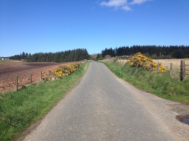
Moss of Byth is a picturesque wood located in Aberdeenshire, Scotland. Encompassing an area of approximately 500 acres, this forest is a haven for nature enthusiasts and outdoor adventurers alike. The wood is situated in the vast estate of Byth, which is renowned for its natural beauty and rich history.

Moss of Byth is characterized by its dense tree cover, dominated by a variety of species including oak, birch, and pine. The forest floor is adorned with a carpet of lush moss, which lends the wood its name. The thick foliage provides a sanctuary for an array of wildlife, including deer, red squirrels, and a diverse range of bird species.

The wood offers an extensive network of trails and paths, allowing visitors to explore its captivating beauty. Hiking and walking are popular activities, providing an opportunity to immerse oneself in the serene surroundings and discover hidden gems within the wood. Additionally, Moss of Byth is a favored spot for birdwatchers, who can catch glimpses of rare and migratory species.

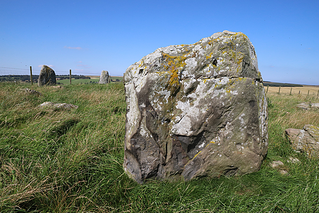
The historical significance of Moss of Byth adds to its charm. The wood has ancient origins and is believed to have been inhabited since prehistoric times. Ruins of stone circles and burial grounds have been discovered within the forest, offering a glimpse into the lives of the early settlers of the area.

Overall, Moss of Byth in Aberdeenshire is a captivating wood that combines natural beauty with a rich historical tapestry. Its lush foliage, abundant wildlife, and tranquil atmosphere make it a must-visit destination for nature lovers and those seeking a peaceful retreat.

If you have any feedback on the listing, please let us know in the comments section below.

Moss of Byth Images

Images are sourced within 2km of 57.594806/-2.2939614 or Grid Reference NJ8256. Thanks to Geograph Open Source API. All images are credited.

War memorial, New Byth On a green where Urquhart Road meets Main Street.
War memorial, New Byth
On a green where Urquhart Road meets Main Street.
Maudmoss Fields north of New Byth.
Maudmoss
Fields north of New Byth.
Buchan stubble A vast expanse of arable ground near New Byth.
Buchan stubble
A vast expanse of arable ground near New Byth.
Minor road near Upper Cook
New Byth This building at the edge of the village was formerly used as a hall and is now a garage.
New Byth
This building at the edge of the village was formerly used as a hall and is now a garage.
Upper Auchnagorth Stone Circle (1) There are ten stones in this circle, three of which are still erect. A fence runs close to two of these, which rather spoils the effect. See <span class="nowrap"><a title="https://canmore.org.uk/site/19926/upper-auchnagorth" rel="nofollow ugc noopener" href="https://canmore.org.uk/site/19926/upper-auchnagorth">Link</a><img style="margin-left:2px;" alt="External link" title="External link - shift click to open in new window" src="https://s1.geograph.org.uk/img/external.png" width="10" height="10"/></span> for more details. <a href="https://www.geograph.org.uk/photo/6251863">NJ8356 : Upper Auchnagorth Stone Circle (2)</a>
Upper Auchnagorth Stone Circle (1)
There are ten stones in this circle, three of which are still erect. A fence runs close to two of these, which rather spoils the effect. See LinkExternal link for more details. NJ8356 : Upper Auchnagorth Stone Circle (2)
Upper Auchnagorth Stone Circle (2) There are ten stones in this circle, three of which are still erect. In this view the largest stone is closest to the camera. See <span class="nowrap"><a title="https://canmore.org.uk/site/19926/upper-auchnagorth" rel="nofollow ugc noopener" href="https://canmore.org.uk/site/19926/upper-auchnagorth">Link</a><img style="margin-left:2px;" alt="External link" title="External link - shift click to open in new window" src="https://s1.geograph.org.uk/img/external.png" width="10" height="10"/></span> for more details. <a href="https://www.geograph.org.uk/photo/6251864">NJ8356 : Upper Auchnagorth Stone Circle (3)</a>
Upper Auchnagorth Stone Circle (2)
There are ten stones in this circle, three of which are still erect. In this view the largest stone is closest to the camera. See LinkExternal link for more details. NJ8356 : Upper Auchnagorth Stone Circle (3)
Upper Auchnagorth Stone Circle (3) There are ten stones in this circle, three of which are still erect. This is largest stone, which fortunately is large enough to hide a rather unappealing concrete building in the background! See <span class="nowrap"><a title="https://canmore.org.uk/site/19926/upper-auchnagorth" rel="nofollow ugc noopener" href="https://canmore.org.uk/site/19926/upper-auchnagorth">Link</a><img style="margin-left:2px;" alt="External link" title="External link - shift click to open in new window" src="https://s1.geograph.org.uk/img/external.png" width="10" height="10"/></span> for more details. <a href="https://www.geograph.org.uk/photo/6251867">NJ8356 : Upper Auchnagorth Stone Circle (4)</a>
Upper Auchnagorth Stone Circle (3)
There are ten stones in this circle, three of which are still erect. This is largest stone, which fortunately is large enough to hide a rather unappealing concrete building in the background! See LinkExternal link for more details. NJ8356 : Upper Auchnagorth Stone Circle (4)
Upper Auchnagorth Stone Circle (4) There are ten stones in this circle, three of which are still erect. These are some of the fallen stones, with two of the erect ones in the background. See <span class="nowrap"><a title="https://canmore.org.uk/site/19926/upper-auchnagorth" rel="nofollow ugc noopener" href="https://canmore.org.uk/site/19926/upper-auchnagorth">Link</a><img style="margin-left:2px;" alt="External link" title="External link - shift click to open in new window" src="https://s1.geograph.org.uk/img/external.png" width="10" height="10"/></span> for more details. <a href="https://www.geograph.org.uk/photo/6251869">NJ8356 : Upper Auchnagorth Stone Circle (5)</a>
Upper Auchnagorth Stone Circle (4)
There are ten stones in this circle, three of which are still erect. These are some of the fallen stones, with two of the erect ones in the background. See LinkExternal link for more details. NJ8356 : Upper Auchnagorth Stone Circle (5)
Upper Auchnagorth Stone Circle (5) There are ten stones in this circle, three of which are still erect. This view is across some of the fallen stones towards the largest stone. See <span class="nowrap"><a title="https://canmore.org.uk/site/19926/upper-auchnagorth" rel="nofollow ugc noopener" href="https://canmore.org.uk/site/19926/upper-auchnagorth">Link</a><img style="margin-left:2px;" alt="External link" title="External link - shift click to open in new window" src="https://s1.geograph.org.uk/img/external.png" width="10" height="10"/></span> for more details. <a href="https://www.geograph.org.uk/photo/6251871">NJ8356 : Upper Auchnagorth Stone Circle (6)</a>
Upper Auchnagorth Stone Circle (5)
There are ten stones in this circle, three of which are still erect. This view is across some of the fallen stones towards the largest stone. See LinkExternal link for more details. NJ8356 : Upper Auchnagorth Stone Circle (6)
Upper Auchnagorth Stone Circle (6) There are ten stones in this circle, three of which are still erect. These are the two smaller stones, with a fallen stone in front. See <span class="nowrap"><a title="https://canmore.org.uk/site/19926/upper-auchnagorth" rel="nofollow ugc noopener" href="https://canmore.org.uk/site/19926/upper-auchnagorth">Link</a><img style="margin-left:2px;" alt="External link" title="External link - shift click to open in new window" src="https://s1.geograph.org.uk/img/external.png" width="10" height="10"/></span> for more details. <a href="https://www.geograph.org.uk/photo/6251873">NJ8356 : Upper Auchnagorth Stone Circle (7)</a>
Upper Auchnagorth Stone Circle (6)
There are ten stones in this circle, three of which are still erect. These are the two smaller stones, with a fallen stone in front. See LinkExternal link for more details. NJ8356 : Upper Auchnagorth Stone Circle (7)
Upper Auchnagorth Stone Circle (7) There are ten stones in this circle, three of which are still erect.See <span class="nowrap"><a title="https://canmore.org.uk/site/19926/upper-auchnagorth" rel="nofollow ugc noopener" href="https://canmore.org.uk/site/19926/upper-auchnagorth">Link</a><img style="margin-left:2px;" alt="External link" title="External link - shift click to open in new window" src="https://s1.geograph.org.uk/img/external.png" width="10" height="10"/></span> for more details. These fallen stones make up part of the circumference of the circel. <a href="https://www.geograph.org.uk/photo/6251874">NJ8356 : Upper Auchnagorth Stone Circle (8)</a>
Upper Auchnagorth Stone Circle (7)
There are ten stones in this circle, three of which are still erect.See LinkExternal link for more details. These fallen stones make up part of the circumference of the circel. NJ8356 : Upper Auchnagorth Stone Circle (8)
Upper Auchnagorth Stone Circle (8) There are ten stones in this circle, three of which are still erect. These are two of the fallen ones, with a view across Corthie Moss in the background. See <span class="nowrap"><a title="https://canmore.org.uk/site/19926/upper-auchnagorth" rel="nofollow ugc noopener" href="https://canmore.org.uk/site/19926/upper-auchnagorth">Link</a><img style="margin-left:2px;" alt="External link" title="External link - shift click to open in new window" src="https://s1.geograph.org.uk/img/external.png" width="10" height="10"/></span> for more details. <a href="https://www.geograph.org.uk/photo/6251861">NJ8356 : Upper Auchnagorth Stone Circle (1)</a>
Upper Auchnagorth Stone Circle (8)
There are ten stones in this circle, three of which are still erect. These are two of the fallen ones, with a view across Corthie Moss in the background. See LinkExternal link for more details. NJ8356 : Upper Auchnagorth Stone Circle (1)
Upper Auchnagorth The farm steading and a selection of machinery and cattle at Upper Auchnagorth. The house is hidden by the trees.
Upper Auchnagorth
The farm steading and a selection of machinery and cattle at Upper Auchnagorth. The house is hidden by the trees.
Looking towards Upper Auchnamoon Upper Auchnamoon is in the next square, but all the land in the foreground is in this square. The lower part of it looks wet, rushy and difficult to cultivate.
Looking towards Upper Auchnamoon
Upper Auchnamoon is in the next square, but all the land in the foreground is in this square. The lower part of it looks wet, rushy and difficult to cultivate.
Upper Auchnagorth A solid traditional stone farm house, well screened by trees for the worst of the weather.
Upper Auchnagorth
A solid traditional stone farm house, well screened by trees for the worst of the weather.
Upper Auchnagorth Fields beside the track to Upper Auchnagorth.
Upper Auchnagorth
Fields beside the track to Upper Auchnagorth.
Upper Auchnagorth Farmland beside the track to Upper Auchnagorth. That's been a fine clump of Spear Thistles in the left foreground.
Upper Auchnagorth
Farmland beside the track to Upper Auchnagorth. That's been a fine clump of Spear Thistles in the left foreground.
Show me another place!

Moss of Byth is located at Grid Ref: NJ8256 (Lat: 57.594806, Lng: -2.2939614)

Unitary Authority: Aberdeenshire

Police Authority: North East

What 3 Words

///spark.pats.extra. Near New Pitsligo, Aberdeenshire

Nearby Locations

Moss of Byth

Related Wikis

New Byth

New Byth is a small inland planned village in the Banff and Buchan committee area of Aberdeenshire, Scotland, that lies a few miles northeast of Cuminestown...

Crudie

Crudie is a settlement in Aberdeenshire, Scotland. It is situated on the A98. It has a primary school and a war memorial. == References ==

Garmond, Aberdeenshire

Garmond (Scottish Gaelic: Garbh Mhon(adh)) is a linear village in Monquhitter Parish which is located in Aberdeenshire, Scotland. It was founded c.1760...

Netherbrae

Netherbrae is an area of farmland and small crofts in Aberdeenshire, Scotland. It is approximately 8 miles (13 km) north of Turriff and 9 miles (14 km...

Nearby Amenities

Located within 500m of 57.594806,-2.2939614
Power: pole
Lat/Long: 57.5911446/-2.2896772
Power: pole
Lat/Long: 57.5974452/-2.2900298
Generator Source: wind
Power: generator
Lat/Long: 57.596415/-2.2865859
Power: pole
Lat/Long: 57.5981638/-2.2886807
Power: pole
Lat/Long: 57.5976809/-2.2890776
Power: pole
Lat/Long: 57.5930743/-2.2885238
Power: pole
Lat/Long: 57.5937094/-2.288141
Power: pole
Lat/Long: 57.5943057/-2.2877806
Power: pole
Lat/Long: 57.5939835/-2.2866676
Power: pole
Lat/Long: 57.5929683/-2.3007918
Power: pole
Lat/Long: 57.5932719/-2.2997496
Power: pole
Lat/Long: 57.5978984/-2.2881068
Power: pole
Lat/Long: 57.5971755/-2.2910951
Power: pole
Lat/Long: 57.5968429/-2.2920503
Power: pole
Lat/Long: 57.5965013/-2.2930203
Power: pole
Lat/Long: 57.5961256/-2.2940686
Power: pole
Lat/Long: 57.5958226/-2.2949539
Power: pole
Lat/Long: 57.5955003/-2.2958985
Power: pole
Lat/Long: 57.5951938/-2.2967393
Power: pole
Lat/Long: 57.5947001/-2.2975123
Power: pole
Lat/Long: 57.5942371/-2.2982303
Power: pole
Lat/Long: 57.5937535/-2.2989821
Power: pole
Lat/Long: 57.5951212/-2.2981011
Power: pole
Lat/Long: 57.5955786/-2.2987449
Power: pole
Lat/Long: 57.5960689/-2.2994333
Power: pole
Lat/Long: 57.5965694/-2.3001258
Power: pole
Lat/Long: 57.5967362/-2.3011191
Power: pole
Lat/Long: 57.5915907/-2.289584
Power: pole
Lat/Long: 57.5919778/-2.2892833
Power: pole
Lat/Long: 57.5924011/-2.2889296
Power: pole
Lat/Long: 57.5958084/-2.2929726
Power: pole
Lat/Long: 57.5955237/-2.2919889
Power: pole
Lat/Long: 57.5952099/-2.2909047
Power: pole
Lat/Long: 57.594913/-2.289879
Power: pole
Lat/Long: 57.5946119/-2.2888386
The data included in this document is from www.openstreetmap.org. The data is made available under ODbL.

Have you been to Moss of Byth?

Leave your review of Moss of Byth below (or comments, questions and feedback).