Horseshoe Wood

Wood, Forest in Roxburghshire

Scotland

Horseshoe Wood

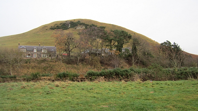
Hownham Mains Hownam has several spellings knocking around various maps:Hownam, Hounam, Hownham.
Hownham Mains Credit: Richard Webb

Horseshoe Wood is a picturesque woodland located in the county of Roxburghshire, Scotland. Situated near the small village of Horseshoe, the wood is a popular destination for nature lovers and outdoor enthusiasts.

Covering an area of approximately 100 acres, Horseshoe Wood is a mix of ancient and plantation woodland, offering a diverse range of flora and fauna. The wood is primarily made up of native species such as oak, birch, and rowan trees, which provide a beautiful canopy of greenery throughout the year.

The wood is crisscrossed by a network of well-maintained footpaths, allowing visitors to explore its many hidden treasures. As one walks through Horseshoe Wood, they will encounter a variety of wildlife, including red squirrels, roe deer, and a plethora of bird species. The tranquil atmosphere and abundance of wildlife make it an ideal spot for birdwatching and nature photography.

In addition to its natural beauty, Horseshoe Wood also has a rich historical background. The remains of an Iron Age fort can be found within its boundaries, providing a glimpse into the region's ancient past. The wood has also been a source of timber for centuries, with evidence of old sawpits and charcoal hearths scattered throughout.

With its combination of natural beauty, diverse wildlife, and historical significance, Horseshoe Wood offers a captivating experience for visitors of all ages. Whether one seeks a peaceful stroll through nature, a chance to observe wildlife, or a deeper understanding of the area's heritage, this woodland is a must-visit destination in Roxburghshire.

If you have any feedback on the listing, please let us know in the comments section below.

Horseshoe Wood Images

Images are sourced within 2km of 55.464288/-2.3394816 or Grid Reference NT7818. Thanks to Geograph Open Source API. All images are credited.

Hownham Mains Hownam has several spellings knocking around various maps:Hownam, Hounam, Hownham.
Hownham Mains
Hownam has several spellings knocking around various maps:Hownam, Hounam, Hownham.
View from Hownam Steeple Over the headwaters of the Hownam Burn.
View from Hownam Steeple
Over the headwaters of the Hownam Burn.
Kale Water and tree From Heavyside Bridge, downstream.
Kale Water and tree
From Heavyside Bridge, downstream.
Kale Water Downstream from Heavyside Bridge
Kale Water
Downstream from Heavyside Bridge
Grassland under Hownam Law Soon to be cut for silage, this grassland is adjacent to cattle and sheep grazing land on the approach to Hownam Law from Howgate.  The prominent hill in the distance, centre of view is Dirrington Great Law (398 metres) near Longformacus.
Grassland under Hownam Law
Soon to be cut for silage, this grassland is adjacent to cattle and sheep grazing land on the approach to Hownam Law from Howgate. The prominent hill in the distance, centre of view is Dirrington Great Law (398 metres) near Longformacus.
Onlookers encountered on the descent from Hownam Law The route back down from Hownam Law to Howgate passes cattle grazing land on former cultivation terraces.
Onlookers encountered on the descent from Hownam Law
The route back down from Hownam Law to Howgate passes cattle grazing land on former cultivation terraces.
Kale Water from Heavyside Bridge A view downstream from Heavyside Bridge.  Hownam Law - right of centre in the distance - looks somewhat belittled from this vantage point.
Kale Water from Heavyside Bridge
A view downstream from Heavyside Bridge. Hownam Law - right of centre in the distance - looks somewhat belittled from this vantage point.
View to The Schill The border ridge beyond See Few as seen from Windy Law. Clear here but to the south the ridge was holding back a lot of cloud formed by a south easterly. It was astonishingly warm.
View to The Schill
The border ridge beyond See Few as seen from Windy Law. Clear here but to the south the ridge was holding back a lot of cloud formed by a south easterly. It was astonishingly warm.
The Street Climb over Craik Moor.
The Street
Climb over Craik Moor.
Berry Hills Craik Moor, Cheviot Hills.
Berry Hills
Craik Moor, Cheviot Hills.
Craik Moor The Street follows a fence dividing grass from heather.
Craik Moor
The Street follows a fence dividing grass from heather.
West side of Craik Moor
Berry Hills West flank of Craik Moor.
Berry Hills
West flank of Craik Moor.
Gate below Craik Moor A crossing of an electric fence. Turnip field on the downhill side.
Gate below Craik Moor
A crossing of an electric fence. Turnip field on the downhill side.
Hownam to Belford road A fine green track between Kale Water and Bowmont.
Hownam to Belford road
A fine green track between Kale Water and Bowmont.
Field on The Kip Descent to the Hownam to Belford road from Place Hill.
Field on The Kip
Descent to the Hownam to Belford road from Place Hill.
Standing Stone near Horseshoe Wood Scale 1m <span class="nowrap"><a title="https://canmore.org.uk/site/57969/horseshoe-wood" rel="nofollow ugc noopener" href="https://canmore.org.uk/site/57969/horseshoe-wood">Link</a><img style="margin-left:2px;" alt="External link" title="External link - shift click to open in new window" src="https://s1.geograph.org.uk/img/external.png" width="10" height="10"/></span>
Standing Stone near Horseshoe Wood
Scale 1m LinkExternal link
Smithy, Hownam
Smithy, Hownam
Show me another place!

Horseshoe Wood is located at Grid Ref: NT7818 (Lat: 55.464288, Lng: -2.3394816)

Unitary Authority: The Scottish Borders

Police Authority: The Lothians and Scottish Borders

What 3 Words

///fairway.trombone.export. Near Jedburgh, Scottish Borders

Nearby Locations

Horseshoe Wood

Related Wikis

Hownam

Hownam or Hounam is a small village and parish situated 8 miles east of Jedburgh in the Scottish Borders area of Scotland, near the Anglo-Scottish border...

Mowhaugh

Mowhaugh is a hamlet and farm steading near the Calroust Burn and the Bowmont Water, near Morebattle, in the Scottish Borders area of Scotland, and in...

Pennymuir Roman camps

The Pennymuir Roman camps are situated southeast of Jedburgh in the Scottish Borders area of Scotland, near the Anglo-Scottish border, in the former Roxburghshire...

Morebattle

Morebattle is a village in the Scottish Borders area of Scotland, on the B6401, seven miles south of Kelso, Scottish Borders, beside the Kale Water, a...

Have you been to Horseshoe Wood?

Leave your review of Horseshoe Wood below (or comments, questions and feedback).