Cunnach Moss

Wood, Forest in Kincardineshire

Scotland

Cunnach Moss

Collonach Plantation Geocaching is a type of global treasure hunt of people looking for caches, or hidden stashes of objects. Geocaching may also be described as a series of hide-and-seek games, where hiders provide online clues for seekers. Seekers use global positioning system (GPS) devices to find hidden caches
Collonach Plantation Credit: Ralph Greig

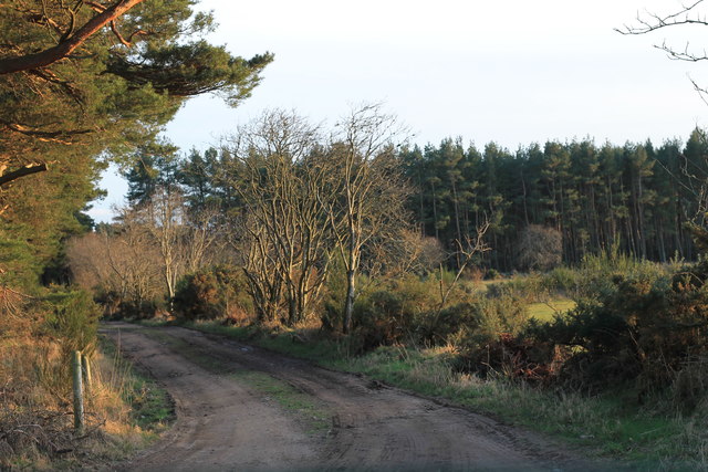
Cunnach Moss is a picturesque woodland located in Kincardineshire, Scotland. The moss is situated in close proximity to the town of Wood, making it easily accessible for visitors. Covering an area of approximately 200 acres, Cunnach Moss is a well-preserved forest that boasts a diverse range of flora and fauna.

The woodland is characterized by its dense coverage of tall, mature trees, creating a serene and tranquil atmosphere for visitors to enjoy. The forest floor is adorned with a variety of mosses, ferns, and wildflowers, adding to the natural beauty of the area.

Cunnach Moss is home to a range of wildlife species, including deer, foxes, badgers, and a wide array of bird species. Nature enthusiasts and birdwatchers flock to the moss to catch a glimpse of the resident and migratory birds that inhabit the area. The woodland also provides a safe habitat for a number of rare and endangered species.

Visitors can explore the moss through a network of well-maintained walking trails, allowing them to fully immerse themselves in the natural surroundings. These trails offer stunning views of the woodland, as well as opportunities for wildlife spotting and photography.

Cunnach Moss is not only a haven for nature lovers but also serves as an important ecosystem, contributing to the local biodiversity and acting as a carbon sink. The moss plays a crucial role in maintaining the ecological balance of the region and provides a valuable resource for scientific research and education.

Overall, Cunnach Moss is a must-visit destination for those seeking a peaceful retreat in the heart of nature, where they can reconnect with the natural world and appreciate the beauty of the Scottish woodlands.

If you have any feedback on the listing, please let us know in the comments section below.

Cunnach Moss Images

Images are sourced within 2km of 57.08658/-2.4086887 or Grid Reference NO7599. Thanks to Geograph Open Source API. All images are credited.

Collonach Plantation Geocaching is a type of global treasure hunt of people looking for caches, or hidden stashes of objects. Geocaching may also be described as a series of hide-and-seek games, where hiders provide online clues for seekers. Seekers use global positioning system (GPS) devices to find hidden caches
Collonach Plantation
Geocaching is a type of global treasure hunt of people looking for caches, or hidden stashes of objects. Geocaching may also be described as a series of hide-and-seek games, where hiders provide online clues for seekers. Seekers use global positioning system (GPS) devices to find hidden caches
Collonach Plantation
Coldstream plantation
Converted Broomfield steading By the minor road from Burnside Quartains.
Converted Broomfield steading
By the minor road from Burnside Quartains.
Access to converted Broomfield Steading Off the minor road from Burnside Quartains.
Access to converted Broomfield Steading
Off the minor road from Burnside Quartains.
Broomfield Cottage At Broomfield minor roads junction.
Broomfield Cottage
At Broomfield minor roads junction.
Entrance to Broomfield Off the minor road to Schoolhill.
Entrance to Broomfield
Off the minor road to Schoolhill.
A barn off Couper's Road North of Broomfield.
A barn off Couper's Road
North of Broomfield.
Field gates and boundary wall With overhead cables running towards Glashmere.
Field gates and boundary wall
With overhead cables running towards Glashmere.
Minor road to Hirn From the Couper's Road junction.
Minor road to Hirn
From the Couper's Road junction.
A view of Lower Candyglirach Through a field gate off the Couper's Road.
A view of Lower Candyglirach
Through a field gate off the Couper's Road.
Fields close to Couper's Road Evening light on Aberdeenshire fields.  In the far distance is the distinctive hill of Bennachie
Fields close to Couper's Road
Evening light on Aberdeenshire fields. In the far distance is the distinctive hill of Bennachie
Fields close to Couper's Road - 2 Evening light on Aberdeenshire fields. In the far distance is the distinctive hill of Bennachie
Fields close to Couper's Road - 2
Evening light on Aberdeenshire fields. In the far distance is the distinctive hill of Bennachie
Cattle by Hoghillock Its cattle grazing in a field Hoghillock Farm lies under the Hill of Fare.
Cattle by Hoghillock
Its cattle grazing in a field Hoghillock Farm lies under the Hill of Fare.
Logs by Todholes Forestry operations are ongoing around the Hill of Fare with a pile of logs awaiting collection by trees at the end of Todholes farm road.
Logs by Todholes
Forestry operations are ongoing around the Hill of Fare with a pile of logs awaiting collection by trees at the end of Todholes farm road.
Candyglirach Farm The tree lined access road to Candyglirach Farm.
Candyglirach Farm
The tree lined access road to Candyglirach Farm.
Woodland Track An access road through woodland by Candyglirach Croft giving access to fields.
Woodland Track
An access road through woodland by Candyglirach Croft giving access to fields.
Wellhead Wetland Wetland rushes by Wellhead with the trees of the Wickerinn Plantation and the Hill of Fare on the skyline.
Wellhead Wetland
Wetland rushes by Wellhead with the trees of the Wickerinn Plantation and the Hill of Fare on the skyline.
Show me another place!

Cunnach Moss is located at Grid Ref: NO7599 (Lat: 57.08658, Lng: -2.4086887)

Unitary Authority: Aberdeenshire

Police Authority: North East

What 3 Words

///restored.household.plod. Near Banchory, Aberdeenshire

Nearby Locations

Cunnach Moss

Related Wikis

Mills of Drum railway station

Mills of Drum railway station was opened in September 1853 by the Deeside Railway and served the rural area around Park House and Crathes estates at the...
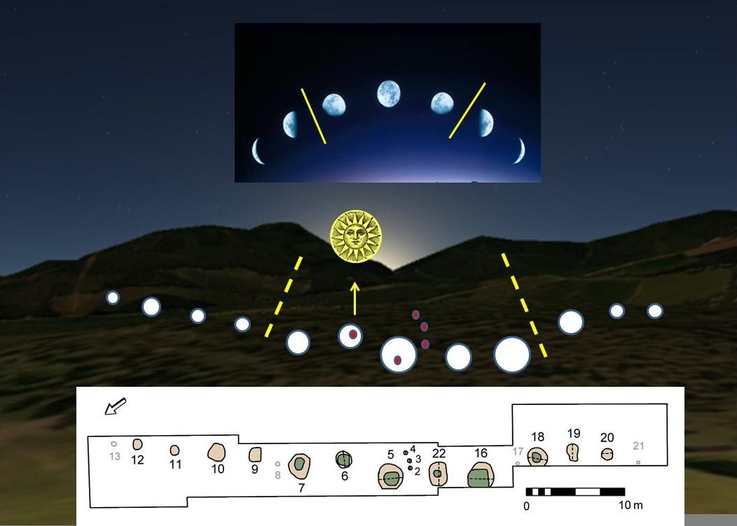
Warren Field

Warren Field is the location of a mesolithic calendar monument built about 8,000 BCE. It includes 12 pits believed to correlate with phases of the Moon...

Crathes Castle

Crathes Castle (pronounced KRATH-iss) is a castle, built in the 16th-century, near Banchory in Aberdeenshire, Scotland. It is in the historic county of...

Royal Deeside Railway

The Royal Deeside Railway is a Scottish heritage railway located at Milton of Crathes railway station on a part of the original Deeside Railway. ��2�...

Nearby Amenities

Located within 500m of 57.08658,-2.4086887
Power: tower
Lat/Long: 57.0867287/-2.414109
Power: pole
Lat/Long: 57.0824288/-2.4104367
Power: pole
Lat/Long: 57.0824551/-2.4077276
Power: pole
Lat/Long: 57.0825192/-2.4089239
Power: tower
Lat/Long: 57.0839601/-2.4110614
The data included in this document is from www.openstreetmap.org. The data is made available under ODbL.

Have you been to Cunnach Moss?

Leave your review of Cunnach Moss below (or comments, questions and feedback).