Blindwells Plantation

Wood, Forest in Roxburghshire

Scotland

Blindwells Plantation

Field, Palace Off the A698 on a dreich day (hence lack of light and colour).
Field, Palace Credit: JThomas

Blindwells Plantation is a picturesque woodland area located in Roxburghshire, Scotland. Spread across an expansive area, this forested landscape is a haven for nature enthusiasts and outdoor adventurers alike. The plantation is nestled within the serene countryside, offering a tranquil escape from the bustling city life.

The woodland is predominantly composed of a variety of native tree species, including oak, birch, and beech, creating a diverse and vibrant ecosystem. The trees stand tall and proud, their branches interlocking to form a dense canopy that filters sunlight, creating a cool and shaded ambiance below. The forest floor is covered in a thick carpet of moss, ferns, and wildflowers, adding to the enchanting atmosphere.

Blindwells Plantation is home to a wide array of wildlife, making it a prime spot for nature lovers. Birds chirp melodiously overhead, while squirrels scurry amongst the branches. Deer can sometimes be spotted gracefully navigating through the undergrowth, adding a touch of grace and majesty to the surroundings.

For those seeking outdoor activities, the plantation offers numerous walking and hiking trails that meander through the forest. These trails vary in difficulty, catering to both casual strollers and seasoned hikers. Along the way, visitors can enjoy breathtaking views, discover hidden streams, and encounter secluded clearings perfect for a peaceful picnic.

Blindwells Plantation is not only a place of natural beauty but also a testament to the importance of preserving and nurturing our natural environment. Its serene setting and abundant biodiversity make it a true gem in the heart of Roxburghshire, attracting visitors from far and wide.

If you have any feedback on the listing, please let us know in the comments section below.

Blindwells Plantation Images

Images are sourced within 2km of 55.506254/-2.4849146 or Grid Reference NT6923. Thanks to Geograph Open Source API. All images are credited.

Field, Palace Off the A698 on a dreich day (hence lack of light and colour).
Field, Palace
Off the A698 on a dreich day (hence lack of light and colour).
A698 heading east Towards Kelso.
A698 heading east
Towards Kelso.
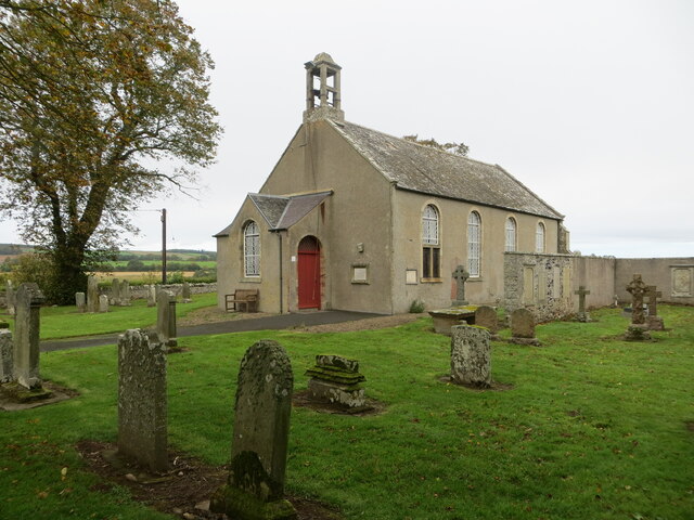
Crailing Kirk A scenic little kirk slightly above the Teviot floodplain and thus escaping the worst the winter floods can bring to the area.
Crailing Kirk
A scenic little kirk slightly above the Teviot floodplain and thus escaping the worst the winter floods can bring to the area.
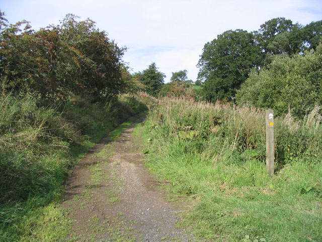
Minor road near Baittens This ection of road also forms part of the route of St Cuthbert's Way, as indicated by the fingerpost on the far side of the road.
Minor road near Baittens
This ection of road also forms part of the route of St Cuthbert's Way, as indicated by the fingerpost on the far side of the road.
Across the fields to Crailing A view towards Crailing in pleasant early June conditions.
Across the fields to Crailing
A view towards Crailing in pleasant early June conditions.
Grazing land hosting sheep and hay bales Looking south-westward.
Grazing land hosting sheep and hay bales
Looking south-westward.
Hedge-lined minor road at Baittens Looking north-eastward.
Hedge-lined minor road at Baittens
Looking north-eastward.
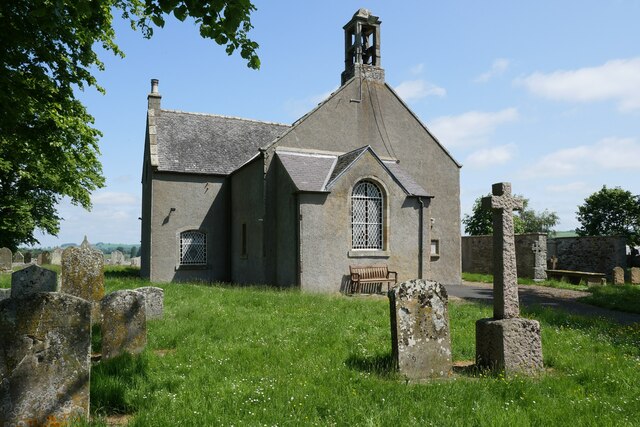
Crailing Parish Church and part of its burial ground Viewed from the southwest.
Crailing Parish Church and part of its burial ground
Viewed from the southwest.
Ordnance Survey Cut Mark This mark can be found at the porch entrance to Crailing Kirk.
The recorded details give a height of 59.2684 metres above sea level.
For more details see : <span class="nowrap"><a title="https://www.bench-marks.org.uk/bm205111" rel="nofollow ugc noopener" href="https://www.bench-marks.org.uk/bm205111">Link</a><img style="margin-left:2px;" alt="External link" title="External link - shift click to open in new window" src="https://s1.geograph.org.uk/img/external.png" width="10" height="10"/></span>
Ordnance Survey Cut Mark
This mark can be found at the porch entrance to Crailing Kirk. The recorded details give a height of 59.2684 metres above sea level. For more details see : LinkExternal link
Guinea fowl at Crailing Parish Churchyard Nine birds were in the churchyard but as I got a bit closer they became noisy and some of them flew on to the northwest boundary wall.
Guinea fowl at Crailing Parish Churchyard
Nine birds were in the churchyard but as I got a bit closer they became noisy and some of them flew on to the northwest boundary wall.
House and farm buildings at Brownrigg
Cattle and Hay sheds at Crailinghall Farm
Barn at Brownrigg - on the St.Cuthbert's Way long distance footpath
Footbridge near Fox Covert on the St.Cuthbert's Way
A short tarmac section of St.Cuthbert's Way long distance footpath The long distance footpath comes towards the photographer. This is the Crailing road. The ldf then exits to the right of picture and returns to tracks at Brownrigg 100m away.
A short tarmac section of St.Cuthbert's Way long distance footpath
The long distance footpath comes towards the photographer. This is the Crailing road. The ldf then exits to the right of picture and returns to tracks at Brownrigg 100m away.
Fox Covert North east edge
Fox Covert
North east edge
Woodland at Tod's Dean
Agricultural Shed The only building marked on this square in the Outdoor Leisure 16 (1:25000) map
Agricultural Shed
The only building marked on this square in the Outdoor Leisure 16 (1:25000) map
Show me another place!

Blindwells Plantation is located at Grid Ref: NT6923 (Lat: 55.506254, Lng: -2.4849146)

Unitary Authority: The Scottish Borders

Police Authority: The Lothians and Scottish Borders

What 3 Words

///fruits.series.crowned. Near Jedburgh, Scottish Borders

Nearby Locations

Blindwells Plantation

Related Wikis

Crailing

Crailing is a village on the A698, in Teviotdale, 4m east of Jedburgh in the Scottish Borders area of Scotland, in the historic county of Roxburghshire...

Roxburghshire

Roxburghshire or the County of Roxburgh (Scottish Gaelic: Siorrachd Rosbroig) is a historic county and registration county in the Southern Uplands of Scotland...

Roxburgh, Ettrick and Lauderdale

Roxburgh, Ettrick and Lauderdale (Rosbrog, Eadaraig agus Srath Labhdair in Scottish Gaelic) is a lieutenancy area of Scotland. The lieutenancy area was...

Crailinghall

Crailinghall is a village near Oxnam in the Scottish Borders area of Scotland, in the former Roxburghshire. Crailinghall is on the route of the St. Cuthbert...

Nisbet, Scottish Borders

Nisbet is a small hamlet on the B6400, in Roxburghshire, along the River Teviot, in the Scottish Borders area of Scotland. It is located 5.5 kilometres...

Nisbet railway station

Nisbet railway station served the hamlet of Nisbet, Scottish Borders, Scotland from 1856 to 1948, on the Jedburgh Railway. == History == The station opened...

Eckford, Scottish Borders

Eckford is a small village located between the larger towns of Kelso and Jedburgh in the Scottish Borders. The village is in close proximity to both the...

Kale Water

The Kale Water is a 20 miles (32 km) long tributary of the River Teviot in the Scottish Borders area of Scotland. Its feeder burns in the Cheviot Hills...

Nearby Amenities

Located within 500m of 55.506254,-2.4849146
Natural: peak
Lat/Long: 55.5021524/-2.486066
Barrier: kissing_gate
Lat/Long: 55.5034265/-2.4866313
The data included in this document is from www.openstreetmap.org. The data is made available under ODbL.

Have you been to Blindwells Plantation?

Leave your review of Blindwells Plantation below (or comments, questions and feedback).