Adam's Wood

Wood, Forest in Berwickshire

Scotland

Adam's Wood

An old tractor at Smiddyhill This old model has seen better days.
An old tractor at Smiddyhill Credit: Walter Baxter

Adam's Wood is a picturesque woodland located in the region of Berwickshire in Scotland. Covering an area of approximately 100 acres, it is a popular destination for nature lovers and outdoor enthusiasts. The wood is situated near the small village of Berwickshire, offering convenient access for visitors.

The wood boasts a diverse range of flora and fauna, with a mix of native trees such as oak, beech, and birch forming a dense canopy overhead. The forest floor is carpeted with a variety of wildflowers, creating a vibrant and colorful landscape during the spring and summer months. The wood is also home to a rich assortment of wildlife, including deer, foxes, badgers, and a wide array of bird species.

Several well-maintained walking trails crisscross through Adam's Wood, providing visitors with the opportunity to explore its natural beauty. These trails cater to different skill levels, with some offering easy and leisurely strolls, while others provide more challenging hikes for the adventurous.

In addition to its natural charm, Adam's Wood also offers recreational facilities for visitors. There are picnic areas and benches scattered throughout the wood, providing a perfect spot for a relaxing lunch or a peaceful moment surrounded by nature. The wood is also equipped with designated areas for camping and barbecues, allowing visitors to extend their stay and make the most of their experience.

Overall, Adam's Wood in Berwickshire is a stunning location that offers a tranquil escape from the hustle and bustle of daily life. Its diverse ecosystem, well-maintained trails, and recreational facilities make it an ideal destination for nature enthusiasts and those seeking a peaceful retreat.

If you have any feedback on the listing, please let us know in the comments section below.

Adam's Wood Images

Images are sourced within 2km of 55.847543/-2.5003366 or Grid Reference NT6861. Thanks to Geograph Open Source API. All images are credited.

An old tractor at Smiddyhill This old model has seen better days.
An old tractor at Smiddyhill
This old model has seen better days.
A detail on an old tractor at Smiddyhill The information on the small panel lower left reads:

MADE IN ENGLAND BY
INTERNATIONAL HARVESTER CO.
OF GREAT BRITAIN LTD.
MODEL B-250 DIESEL
SERIAL NO. 22727
MAX IDLE SPEED 1925 R.P.M.
DO NOT OVERLOAD

For a view of the tractor, see <a href="https://www.geograph.org.uk/photo/7107516">NT6961 : An old tractor at Smiddyhill</a>.
A detail on an old tractor at Smiddyhill
The information on the small panel lower left reads: MADE IN ENGLAND BY INTERNATIONAL HARVESTER CO. OF GREAT BRITAIN LTD. MODEL B-250 DIESEL SERIAL NO. 22727 MAX IDLE SPEED 1925 R.P.M. DO NOT OVERLOAD For a view of the tractor, see NT6961 : An old tractor at Smiddyhill.
Drunken signpost But still giving good directions.
Beside Whiteadder Water.
Drunken signpost
But still giving good directions. Beside Whiteadder Water.
Cranshaws Village Hall Cranshaws Village Hall was opened as a recreational hall in the 1920s and has a prominent site in the middle of the village. The hall has recently been refurbished with new toilets and a new kitchen.
Regular events in Cranshaws Village Hall include Carpet Bowling, Concerts, Family Fun Days, Community parties, Art and craft workshops and courses and Big Screen International Rugby days.
Cranshaws Village Hall
Cranshaws Village Hall was opened as a recreational hall in the 1920s and has a prominent site in the middle of the village. The hall has recently been refurbished with new toilets and a new kitchen. Regular events in Cranshaws Village Hall include Carpet Bowling, Concerts, Family Fun Days, Community parties, Art and craft workshops and courses and Big Screen International Rugby days.
Smiddy Hill Farm Overlooking Whiteadder Water.
Smiddy Hill Farm
Overlooking Whiteadder Water.
The B6355 on Smiddyhill Bridge, which bridges Whiteadder Water
Smiddyhill Bridge over Whiteadder Water, near Cranshaws
Whiteadder Water upstream from Smiddyhill Bridge, near Cranshaws
Track and footpath off the B6355 near Cranshaws
Bridge over the Boontree Burn, on the B6355, near Cranshaws
Cranshaws Church of Scotland kirk, in the Scottish Borders
Cranshaws Church of Scotland kirk interior
Cranshaws Church of Scotland kirk showing apsidal east end
Cranshaws Church of Scotland kirk - detail from exterior of east end
Whiteadder Water from road bridge north of Cranshaws
Road junction - the B6355 with a minor road, near Cranshaws
Craigs Windshiel Access Gate at bottom of surfaced road to the farm of Craigs Windshiel. I had intended to go past the farm but as I had my terrier with me decided not too  - sign says 'Farm livestock with their young'.
In fact by chance I stumbled on a new path nearby at Smiddyhill Bridge on the east side of Whitteadder Water taking me all the way to the minor road to Harehead which was where I was headed.
Craigs Windshiel Access
Gate at bottom of surfaced road to the farm of Craigs Windshiel. I had intended to go past the farm but as I had my terrier with me decided not too - sign says 'Farm livestock with their young'. In fact by chance I stumbled on a new path nearby at Smiddyhill Bridge on the east side of Whitteadder Water taking me all the way to the minor road to Harehead which was where I was headed.
Rise Lea On the slopes of Rise Lea near Cranshaws. Lovely sky with high level cloud, taken from new path above the Whitteadder Water.
Rise Lea
On the slopes of Rise Lea near Cranshaws. Lovely sky with high level cloud, taken from new path above the Whitteadder Water.
Show me another place!

Adam's Wood is located at Grid Ref: NT6861 (Lat: 55.847543, Lng: -2.5003366)

Unitary Authority: The Scottish Borders

Police Authority: The Lothians and Scottish Borders

What 3 Words

///habits.pressing.strictly. Near Duns, Scottish Borders

Related Wikis

Bothwell Water

The Bothwell Water is a river in the Scottish Borders area of Scotland. It rises in the Lammermuir Hills near Caldercleugh and continues past the Upper...

Cranshaws Castle

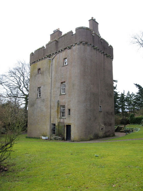
Cranshaws Castle or Cranshaws Tower is a privately owned 15th-century pele situated by the village of Cranshaws in Berwickshire, Scotland. The building...

Cranshaws

Cranshaws is a village on the B6355 road, near Duns, in the Scottish Borders area of Scotland, in the former Berwickshire. Of Cranshaws Castle only the...

Dye Water

The Dye Water (Scottish Gaelic: Uisge DhĂ idh) is a river in the Lammermuir Hills in the Scottish Borders area of Scotland. It rises in the Hope Hills,...

Nearby Amenities

Located within 500m of 55.847543,-2.5003366
Post Box
Post Box Mounting: telegraph_pole
Post Box Type: lamp
Ref: TD11 26
Lat/Long: 55.8497579/-2.4951687
Council Houses
Naptan AtcoCode: 69001243
Naptan Bearing: S
Naptan BusStopType: CUS
Naptan CommonName: Council Houses
Naptan Indicator: o/s
Naptan Landmark: Council Houses
Naptan NaptanCode: 72725826
Naptan Street: B6355
Naptan Verified: no
Source: naptan_import
Lat/Long: 55.8498481/-2.4947849
Cranshaws
Place: hamlet
Wikidata: Q5182255
Wikipedia: en:Cranshaws
Lat/Long: 55.8494798/-2.495093
Telephone
Booth: K6
Covered: booth
Source: survey
Lat/Long: 55.850144/-2.4952024
Bicycle Repair Station
Service Bicycle Pump: yes
Service Bicycle Stand: yes
Lat/Long: 55.8501587/-2.4952011
Defibrillator
Defibrillator Location: outside Cranshaws Recreational Hall - near red phone box
Emergency: defibrillator
Indoor: no
Lat/Long: 55.850185/-2.4951763
Power: pole
Lat/Long: 55.8489828/-2.4929125
Power: pole
Lat/Long: 55.8494223/-2.4931896
Power: pole
Lat/Long: 55.8498348/-2.4934972
Power: pole
Lat/Long: 55.8500973/-2.4943259
Power: pole
Lat/Long: 55.8503499/-2.4949843
Power: pole
Lat/Long: 55.8509036/-2.4956351
Power: pole
Lat/Long: 55.8507994/-2.4973307
Power: pole
Lat/Long: 55.8506967/-2.4991
Power: pole
Lat/Long: 55.8505925/-2.5008312
Power: pole
Lat/Long: 55.8504898/-2.502598
Power: pole
Lat/Long: 55.8503884/-2.5042479
Power: pole
Lat/Long: 55.8503/-2.5058646
Power: pole
Lat/Long: 55.8502657/-2.5065332
The data included in this document is from www.openstreetmap.org. The data is made available under ODbL.

Have you been to Adam's Wood?

Leave your review of Adam's Wood below (or comments, questions and feedback).