Williescrook Plantation

Wood, Forest in Roxburghshire

Scotland

Williescrook Plantation

Path by Jedburgh Golf Course The path is part of the Circular Riding Route and follows the golf course boundary towards Lanton Hill.
Path by Jedburgh Golf Course Credit: Jim Barton

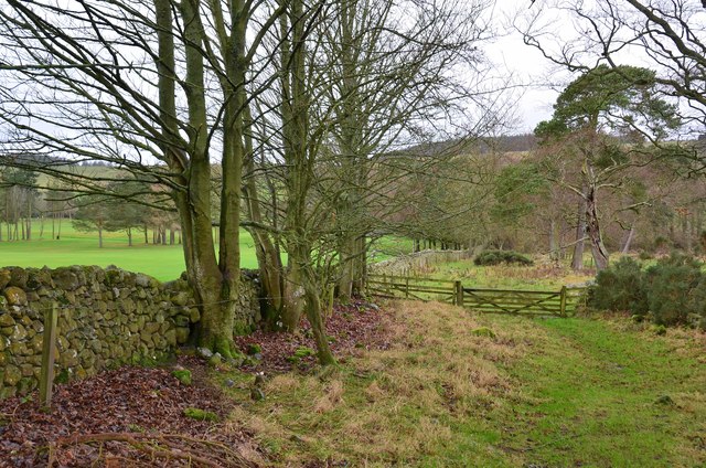
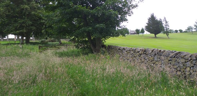
Williescrook Plantation is a charming woodland located in Roxburghshire, a historic county in the Scottish Borders region of Scotland. Covering a vast area, this plantation is known for its lush and diverse forest, making it a popular destination for nature enthusiasts and outdoor lovers.

The woodland is home to a variety of tree species, including oak, beech, birch, and pine, creating a captivating landscape that changes with the seasons. The vibrant colors of the leaves in autumn and the fresh greenery in spring offer a visually stunning experience for visitors.

The plantation also boasts a network of well-maintained trails, allowing visitors to explore the area at their own pace. These paths wind through the forest, offering glimpses of wildlife such as deer, squirrels, and various bird species. Nature photographers will find plenty of opportunities to capture stunning shots of the local flora and fauna.

For those seeking a peaceful retreat, Williescrook Plantation offers several picnic areas and benches scattered throughout the woodland. Visitors can relax and immerse themselves in the tranquil surroundings, enjoying the sounds of birdsong and the gentle rustling of leaves.

This picturesque woodland is easily accessible, with a car park available for visitors. Whether you are looking for a leisurely stroll, a family outing, or a chance to connect with nature, Williescrook Plantation is a must-visit destination in Roxburghshire.

If you have any feedback on the listing, please let us know in the comments section below.

Williescrook Plantation Images

Images are sourced within 2km of 55.487327/-2.5673984 or Grid Reference NT6421. Thanks to Geograph Open Source API. All images are credited.

Path by Jedburgh Golf Course The path is part of the Circular Riding Route and follows the golf course boundary towards Lanton Hill.
Path by Jedburgh Golf Course
The path is part of the Circular Riding Route and follows the golf course boundary towards Lanton Hill.
Footpath next to Jedburgh Golf Club The footpath which runs along beside Jedburgh Golf Club.
Footpath next to Jedburgh Golf Club
The footpath which runs along beside Jedburgh Golf Club.
Waymarks in Jedburgh Waymarks for the Borders Abbeys Way, Jedburgh Paths, Jedforest Trails, the Justice Trail (a 40km cycle route) and the Jedburgh Circular Riding Route (total length 22km).
Waymarks in Jedburgh
Waymarks for the Borders Abbeys Way, Jedburgh Paths, Jedforest Trails, the Justice Trail (a 40km cycle route) and the Jedburgh Circular Riding Route (total length 22km).
Road to Castlewood Farm Jedburgh town can be seen to the left in the middle distance.
Road to Castlewood Farm
Jedburgh town can be seen to the left in the middle distance.
Steps near Allar's Mill, Jedburgh A long flight of steps leads down from the lane used by the Borders Abbeys Way to the Jed Water, on one of the Jedburgh paths.
Steps near Allar's Mill, Jedburgh
A long flight of steps leads down from the lane used by the Borders Abbeys Way to the Jed Water, on one of the Jedburgh paths.
Bridge at Allar's Mill, Jedburgh A bridge over the Jed Water giving access to the old mill buildings now used as a storage depot.
Bridge at Allar's Mill, Jedburgh
A bridge over the Jed Water giving access to the old mill buildings now used as a storage depot.
A proliferation of walking routes A sign on Galahill indicates a large number of waymarked walking routes based on Jedburgh, including the Border Abbeys Way.
A proliferation of walking routes
A sign on Galahill indicates a large number of waymarked walking routes based on Jedburgh, including the Border Abbeys Way.
Jedburgh Castle Jail Now a museum and visitor attraction.
Jedburgh Castle Jail
Now a museum and visitor attraction.
Houses on Castle Gate, Jedburgh
Castle Gate, Jedburgh The B6358 sharply downhill into Jedburgh.
Castle Gate, Jedburgh
The B6358 sharply downhill into Jedburgh.
The Jubilee fountain and Market Place, Jedburgh Jedburgh Sheriff Court behind.
The Jubilee fountain and Market Place, Jedburgh
Jedburgh Sheriff Court behind.
The Spread Eagle Hotel, Jedburgh On High Street.
The Spread Eagle Hotel, Jedburgh
On High Street.
High Street, Jedburgh From outside the Spread Eagle Hotel.
High Street, Jedburgh
From outside the Spread Eagle Hotel.
George VI postbox on Cannongate, Jedburgh Postbox No. TD8 81.
George VI postbox on Cannongate, Jedburgh
Postbox No. TD8 81.
Post Office and store on Cannongate, Jedburgh
The Royal Hotel, Jedburgh On Cannongate.
The Royal Hotel, Jedburgh
On Cannongate.
Coloured houses on Cannongate, Jedburgh
Jedburgh Abbey View over the park and bandstand.
Jedburgh Abbey
View over the park and bandstand.
Show me another place!

Williescrook Plantation is located at Grid Ref: NT6421 (Lat: 55.487327, Lng: -2.5673984)

Unitary Authority: The Scottish Borders

Police Authority: The Lothians and Scottish Borders

What 3 Words

///mistaking.nods.dribble. Near Jedburgh, Scottish Borders

Related Wikis

St John's Church, Jedburgh

St John's Church is a Scottish Episcopal church (part of the Anglican communion) in Jedburgh. It was founded by Cecil Chetwynd Kerr, Marchioness of Lothian...

Timpendean Tower

Timpendean Tower (tim-pen-deen) or Typenden Castle as it was once known, is a ruined 15th-century tower house near Lanton, around 1.5 miles (2.4 km) north...

Port House

The Port House is a Scottish class A listed building in the centre of Jedburgh. The Jedburgh Co-operative Store Company had been founded in 1866 and it...

Jedburgh Grammar School

Jedburgh Grammar School is a state secondary school in Jedburgh, Scotland, with around 440 pupils, 40 teaching staff, and 15 non-teaching staff. ��2�...

Nearby Amenities

Located within 500m of 55.487327,-2.5673984
Power: pole
Lat/Long: 55.4847942/-2.5612141
Power: pole
Lat/Long: 55.4853839/-2.5606794
Power: pole
Lat/Long: 55.4860041/-2.5600729
Noexit: yes
Lat/Long: 55.4864948/-2.5667889
Sividavey
Addr Postcode: TD8 6SH
Craft: pottery
Website: https://www.sividavey.com
Lat/Long: 55.486877/-2.566448
Power: pole
Lat/Long: 55.4834985/-2.5700406
Power: pole
Lat/Long: 55.4840739/-2.5693177
Power: pole
Lat/Long: 55.4846544/-2.5685873
Power: pole
Lat/Long: 55.4850985/-2.5672626
Power: pole
Lat/Long: 55.4857114/-2.566961
Power: pole
Lat/Long: 55.4863236/-2.5666734
The data included in this document is from www.openstreetmap.org. The data is made available under ODbL.

Have you been to Williescrook Plantation?

Leave your review of Williescrook Plantation below (or comments, questions and feedback).