Beechfield Plantation

Wood, Forest in Berwickshire

Scotland

Beechfield Plantation

Male flowers on a Scots Pine tree The tree is at the southwest end of Bemersyde Moss Nature Reserve.
Male flowers on a Scots Pine tree Credit: Walter Baxter

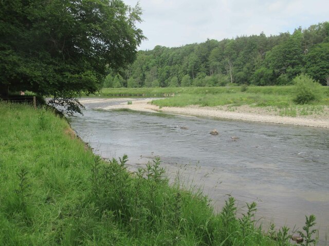
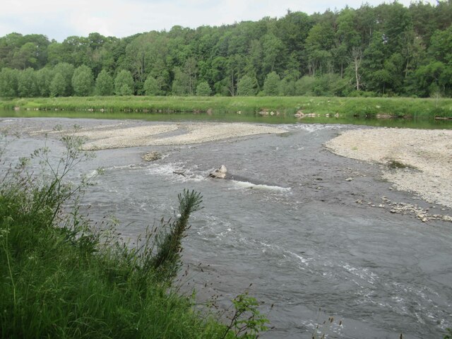
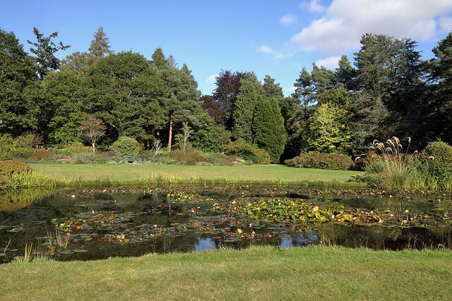
Beechfield Plantation is a picturesque woodland located in Berwickshire, a historic county in the Scottish Borders region of Scotland. Spanning over a vast area, the plantation is known for its dense growth of beech trees, which give it its distinctive name.

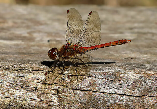
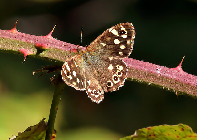
The plantation is a haven for nature lovers and outdoor enthusiasts, offering a tranquil and serene environment. The towering beech trees create a canopy overhead, providing shade and shelter for a variety of wildlife, including birds, squirrels, and deer. The forest floor is carpeted with a lush undergrowth of ferns, mosses, and wildflowers, adding to the natural beauty of the area.

Visitors to Beechfield Plantation can enjoy a plethora of activities. Walking and hiking trails wind their way through the woodland, allowing visitors to explore its hidden gems and discover the abundance of flora and fauna. The paths are well-maintained, making them accessible to people of all ages and abilities.

Photographers are also drawn to Beechfield Plantation due to its picturesque scenery. The dappled sunlight filtering through the dense foliage creates a magical and ethereal atmosphere, providing excellent opportunities for capturing stunning shots.

The plantation is open to the public year-round, and admission is free. It is a popular destination for locals and tourists alike, offering a peaceful retreat from the hustle and bustle of everyday life. Whether it is a leisurely stroll, a birdwatching expedition, or simply a moment of tranquility, Beechfield Plantation is a must-visit destination for nature enthusiasts in Berwickshire.

If you have any feedback on the listing, please let us know in the comments section below.

Beechfield Plantation Images

Images are sourced within 2km of 55.588389/-2.6027131 or Grid Reference NT6232. Thanks to Geograph Open Source API. All images are credited.

Male flowers on a Scots Pine tree The tree is at the southwest end of Bemersyde Moss Nature Reserve.
Male flowers on a Scots Pine tree
The tree is at the southwest end of Bemersyde Moss Nature Reserve.
River Tweed
River Tweed
River Tweed
River Tweed
Mertoun Mill
Mertoun Mill
A male common darter (Sympetrum striolatum) This small narrow-bodied dragonfly was photographed at Mertoun House Estate.
A male common darter (Sympetrum striolatum)
This small narrow-bodied dragonfly was photographed at Mertoun House Estate.
A speckled wood butterfly (Pararge aegeria) The butterfly was photographed at Mertoun House Estate.
A speckled wood butterfly (Pararge aegeria)
The butterfly was photographed at Mertoun House Estate.
A pond at Mertoun House gardens
A small tortoiseshell butterfly (Aglais urticae) Many butterflies were in Mertoun House gardens on this warm September afternoon.
A small tortoiseshell butterfly (Aglais urticae)
Many butterflies were in Mertoun House gardens on this warm September afternoon.
A female common darter (Sympetrum striolatum) This small narrow-bodied dragonfly was photographed at Mertoun House Estate.
A female common darter (Sympetrum striolatum)
This small narrow-bodied dragonfly was photographed at Mertoun House Estate.
Tomatoes at Mertoun House gardens A greenhouse in the gardens had a good crop of tomatoes.
Tomatoes at Mertoun House gardens
A greenhouse in the gardens had a good crop of tomatoes.
Mertoun House gardens There was a good crop of tomatoes in the greenhouse. For a closer view, see <a href="https://www.geograph.org.uk/photo/7287411">NT6131 : Tomatoes at Mertoun House gardens</a>.
Mertoun House gardens
There was a good crop of tomatoes in the greenhouse. For a closer view, see NT6131 : Tomatoes at Mertoun House gardens.
Old milepost The Smith Patterson post opposite the lane to Magdalene Hall Farm had been recently painted in 2019  <a href="https://www.geograph.org.uk/photo/6417102">NT6232 : Close  up  of  milepost  on  B6404</a>  However it would be good to see it dug out and set at its correct height.
Old milepost
The Smith Patterson post opposite the lane to Magdalene Hall Farm had been recently painted in 2019 NT6232 : Close up of milepost on B6404 However it would be good to see it dug out and set at its correct height.
Old milepost The milestone under the beech tree getting ready for winter.
Old milepost
The milestone under the beech tree getting ready for winter.
Old toll house Built of fine dressed red sandstone blocks, the old tollhouse at Mertoun bridge over the River Tweed has a protruding bay window for a view of wheeled vehicles and animals approaching.   There is a door beyond the bay.   The part at the rear is a later addition.
Old toll house
Built of fine dressed red sandstone blocks, the old tollhouse at Mertoun bridge over the River Tweed has a protruding bay window for a view of wheeled vehicles and animals approaching. There is a door beyond the bay. The part at the rear is a later addition.
Winter trees at Whitrighill
A tree sparrow (Passer montanus) at Bemersyde Moss Nature Reserve The bird was viewed from the reserve hide.
A tree sparrow (Passer montanus) at Bemersyde Moss Nature Reserve
The bird was viewed from the reserve hide.
A close up of Golden Shield Lichen (Xanthoria parientina) This foliose lichen was growing on a dead elm twig at Bemersyde Moss Nature Reserve.
A close up of Golden Shield Lichen (Xanthoria parientina)
This foliose lichen was growing on a dead elm twig at Bemersyde Moss Nature Reserve.
A great spotted woodpecker (Dendrocopus major) at Bemersyde Moss Nature Reserve The woodpecker was viewed from the hide on the southeast side of the reserve.
A great spotted woodpecker (Dendrocopus major) at Bemersyde Moss Nature Reserve
The woodpecker was viewed from the hide on the southeast side of the reserve.
Show me another place!

Beechfield Plantation is located at Grid Ref: NT6232 (Lat: 55.588389, Lng: -2.6027131)

Unitary Authority: The Scottish Borders

Police Authority: The Lothians and Scottish Borders

What 3 Words

///paraded.basket.rucksack. Near Saint Boswells, Scottish Borders

Nearby Locations

Beechfield Plantation

Related Wikis

Clintmains

Clintmains is a village by the River Tweed, in the parish of Mertoun, to the east of Newtown St Boswells, in the Scottish Borders area of Scotland, in...

Mertoun

Mertoun is a parish in the south-west of the historic county of Berwickshire in the Scottish Borders area of Scotland. Together with the parish of Maxton...

Mertoun House

Mertoun House is a country house situated by the River Tweed, 2 miles (3 kilometres) east of St Boswells in the Scottish Borders. It is home to the Duke...

Bemersyde Moss

Bemersyde Moss is a Scottish Wildlife Trust nature reserve and a Site of Special Scientific Interest at Bemersyde in the Scottish Borders area of Scotland...

Nearby Amenities

Located within 500m of 55.588389,-2.6027131
Maidenhall
Place: hamlet
Lat/Long: 55.588407/-2.6060957
Danderhall
Place: isolated_dwelling
Lat/Long: 55.5869102/-2.599484
Power: pole
Source: Bing
Lat/Long: 55.591594/-2.597352
Power: pole
Source: Bing
Lat/Long: 55.5912196/-2.5985697
Power: pole
Source: Bing
Lat/Long: 55.5908392/-2.5998598
Power: pole
Source: Bing
Lat/Long: 55.5900926/-2.6023656
Power: pole
Source: Bing
Lat/Long: 55.5904709/-2.6011071
Power: pole
Source: Bing
Lat/Long: 55.5897615/-2.6034674
Power: pole
Source: Bing
Lat/Long: 55.5894523/-2.6045269
Power: pole
Source: Bing
Lat/Long: 55.5890839/-2.6057875
Power: pole
Source: Bing
Lat/Long: 55.5888634/-2.6064956
Power: pole
Source: Bing
Lat/Long: 55.5885231/-2.6076222
Power: pole
Source: Bing
Lat/Long: 55.5881858/-2.6087755
Power: pole
Source: Bing
Lat/Long: 55.5877803/-2.6100335
Power: pole
Lat/Long: 55.588474/-2.6050458
Power: pole
Lat/Long: 55.5880909/-2.6045746
Power: pole
Lat/Long: 55.5874584/-2.6037944
Power: pole
Lat/Long: 55.5867993/-2.6029779
Power: pole
Lat/Long: 55.586162/-2.6021891
Power: pole
Lat/Long: 55.5854752/-2.6013727
Power: pole
Lat/Long: 55.5847945/-2.6007054
Power: pole
Lat/Long: 55.5864596/-2.6010891
Power: pole
Lat/Long: 55.5867656/-2.5999998
The data included in this document is from www.openstreetmap.org. The data is made available under ODbL.

Have you been to Beechfield Plantation?

Leave your review of Beechfield Plantation below (or comments, questions and feedback).