Cow Covert

Wood, Forest in Angus

Scotland

Cow Covert

Track giving access to Wilsonhall Looking north-eastward.
Track giving access to Wilsonhall Credit: Peter Wood

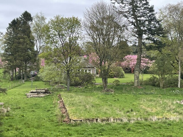
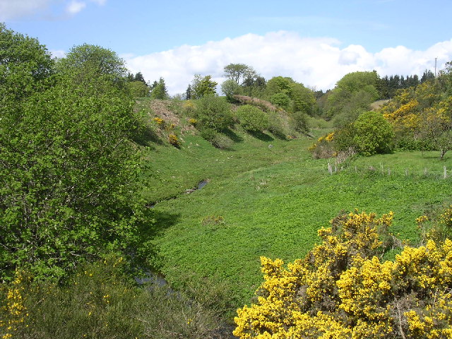
Cow Covert is a dense forest located in the Angus region of Scotland. Situated within the larger Angus Glens, this woodland is known for its captivating beauty and rich biodiversity. Covering an area of approximately 200 acres, Cow Covert is predominantly composed of native species of trees, including oak, birch, and rowan. The forest is situated on undulating terrain, with a mix of gentle slopes and steeper inclines, adding to its scenic charm.

The woodland is home to a diverse range of wildlife, making it a popular destination for nature enthusiasts and wildlife photographers. Visitors to Cow Covert can expect to spot a variety of bird species, such as woodpeckers, tits, and finches, as well as larger animals like red deer, roe deer, and foxes. The forest also provides habitat for smaller mammals, including squirrels, badgers, and hedgehogs.

Cow Covert offers several walking trails, allowing visitors to explore the forest and enjoy its tranquil atmosphere. These paths wind through the trees, providing opportunities for both leisurely strolls and more rigorous hikes. Along the way, walkers can enjoy breathtaking views of the surrounding countryside and may even encounter picturesque streams and waterfalls.

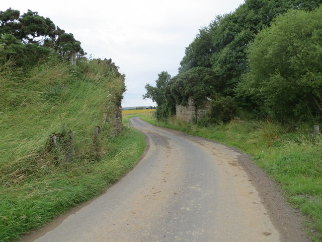
The forest is easily accessible, with a well-maintained car park located at its entrance. Furthermore, there are information boards providing details about the history and ecology of Cow Covert, enhancing the visitor experience. Overall, Cow Covert, Angus (Wood, Forest) is a must-visit destination for those seeking to immerse themselves in the natural beauty of the Angus Glens and witness the wonders of Scotland's wildlife.

If you have any feedback on the listing, please let us know in the comments section below.

Cow Covert Images

Images are sourced within 2km of 56.540698/-2.7679716 or Grid Reference NO5239. Thanks to Geograph Open Source API. All images are credited.

Track giving access to Wilsonhall Looking north-eastward.
Track giving access to Wilsonhall
Looking north-eastward.
Looking east from the side of the Monikie Reservoirs Looking down on the small hamlet of Craigton, it’s school and cherry trees in bloom. I wonder what the outline of the rectangular building in the foreground used to be?
Looking east from the side of the Monikie Reservoirs
Looking down on the small hamlet of Craigton, it’s school and cherry trees in bloom. I wonder what the outline of the rectangular building in the foreground used to be?
Minor road near to Fallaws Wood Looking north-westward through the buttresses of a former railway bridge.
Minor road near to Fallaws Wood
Looking north-westward through the buttresses of a former railway bridge.
Crombie Country Park A short walk around this quiet and peaceful park after a day and a half of rain. Sodden ground but fresh air. A lot of tree damage is evident here from previous winter storms - it will take some clearing.
Crombie Country Park
A short walk around this quiet and peaceful park after a day and a half of rain. Sodden ground but fresh air. A lot of tree damage is evident here from previous winter storms - it will take some clearing.
Road junction near Crombie Mill
Crombie Den
Crombie Den
Farm buildings at Crombie Mill
Crombie reservoir, Crombie Country Park Construction on the reservoir at Crombie started in 1866 and was intended to supplement the nearby reservoir at Monikie in supplying water to the city of Dundee.  The completion of the Lintrathen scheme rendered both reservoirs redundant, with Crombie last supplying water to Carnoustie in 1981.
Crombie reservoir, Crombie Country Park
Construction on the reservoir at Crombie started in 1866 and was intended to supplement the nearby reservoir at Monikie in supplying water to the city of Dundee. The completion of the Lintrathen scheme rendered both reservoirs redundant, with Crombie last supplying water to Carnoustie in 1981.
Saughmont Coppice Some of the extensive woodlands near the Crombie Reservoir.
Saughmont Coppice
Some of the extensive woodlands near the Crombie Reservoir.
Picnic table, Peddieston Wood On the edge of the car park, Crombie Country Park.
Picnic table, Peddieston Wood
On the edge of the car park, Crombie Country Park.
Crombie Reservoir
Crombie Reservoir
Crombie Reservoir
Crombie Reservoir
Path in Peddiestone Wood, Crombie Country Park
Path to Saughmont Covert
Crombie Burn
Crombie Burn
Crombie Mill The house and buildings on the skyline are what remains of the former Crombie Mill. The view is taken in the south west corner of the grid box from the B961  where it crosses the Crombie Burn (see another image for this grid square)
Crombie Mill
The house and buildings on the skyline are what remains of the former Crombie Mill. The view is taken in the south west corner of the grid box from the B961 where it crosses the Crombie Burn (see another image for this grid square)
Crombie Burn The Crombie Burn drains a valley which clearly was eroded by a bigger river than occupies it today.  This view is taken from the B961 in the south west corner of the grid box and looks north west up the valley.  Out of view is Crombie Reservoir (NO5240) which was built in the 1860s to provide water for Dundee.  At that time the Crombie Burn was dammed and the river reduced to its present small dimensions.
Crombie Burn
The Crombie Burn drains a valley which clearly was eroded by a bigger river than occupies it today. This view is taken from the B961 in the south west corner of the grid box and looks north west up the valley. Out of view is Crombie Reservoir (NO5240) which was built in the 1860s to provide water for Dundee. At that time the Crombie Burn was dammed and the river reduced to its present small dimensions.
Crombie reservoir, Crombie Country Park Following outbreaks of cholera and typhoid in nearby Dundee in the 1830s and 40s, reservoirs, including Crombie, were built outside the city to supply clean water to the rapidly growing city.  Crombie reservoir became redundant in the 1980s following the construction of much larger reservoirs at Lintrathen and Backwater.  It now forms the centrepiece of Crombie Country Park.
Crombie reservoir, Crombie Country Park
Following outbreaks of cholera and typhoid in nearby Dundee in the 1830s and 40s, reservoirs, including Crombie, were built outside the city to supply clean water to the rapidly growing city. Crombie reservoir became redundant in the 1980s following the construction of much larger reservoirs at Lintrathen and Backwater. It now forms the centrepiece of Crombie Country Park.
Show me another place!

Cow Covert is located at Grid Ref: NO5239 (Lat: 56.540698, Lng: -2.7679716)

Unitary Authority: Angus

Police Authority: Tayside

What 3 Words

///joystick.weeps.nagging. Near Carnoustie, Angus

Related Wikis

Panmure House

Panmure House was a 17th-century country house in the Parish of Panbride, Angus, Scotland, 4 miles (6 km) to the north of Carnoustie. It was the seat of...

Camuston

Camuston was a village that once existed in Angus, Scotland until the late 18th/early 19th centuries. No trace of it can be found today, but its former...

Camus Cross

The Camus Cross, otherwise known as the Camuston or Camustane Cross, is an Early Medieval Scottish standing stone on the Panmure Estate near Carnoustie...

Downie Hills

The Downie Hills are a small range of hills in Angus, Scotland, approximately 4 kilometres (2.5 mi) to the North of Carnoustie. At their highest point...

Panmure Testimonial

The Panmure Testimonial, otherwise known as the Live and Let Live Memorial, is a monument in Angus, Scotland. It was erected in 1839 to commemorate the...

Craigton, Angus

Craigton is a village in Angus, Scotland. It lies to the north of the Downie Hills, approximately three miles north of Carnoustie. Immediately to the west...

Carnegie Castle

Carnegie Castle was a castle that was located in Angus, Scotland. The Carnegies owned the property between the 15th-18th century. The site of the castle...

Monikie

Monikie is a village and civil parish in Angus, Scotland, north-east of Dundee. == History == The village grew from small beginnings as just one of many...

Nearby Amenities

Located within 500m of 56.540698,-2.7679716
Power: pole
Lat/Long: 56.543597/-2.7741031
The data included in this document is from www.openstreetmap.org. The data is made available under ODbL.

Have you been to Cow Covert?

Leave your review of Cow Covert below (or comments, questions and feedback).