Hareup Plantation
Wood, Forest in East Lothian
Scotland
Hareup Plantation

Hareup Plantation is a magnificent woodland located in East Lothian, Scotland. Spanning over a vast area, it is a prominent and popular destination for nature enthusiasts and outdoor lovers alike. The plantation is situated in a picturesque landscape, surrounded by rolling hills and breathtaking views of the East Lothian countryside.
The woodland is predominantly composed of a variety of tree species, including oak, beech, and birch, creating a diverse and vibrant ecosystem. The rich biodiversity within Hareup Plantation makes it a haven for numerous wildlife species, such as deer, squirrels, and a wide array of bird species. The enchanting flora and fauna make it an ideal location for wildlife spotting and birdwatching.
The plantation offers several walking trails, allowing visitors to explore its natural beauty at their own pace. These trails meander through the dense undergrowth and towering trees, providing a serene and peaceful environment for leisurely strolls or more challenging hikes. The well-maintained paths are suitable for all ages and abilities, making Hareup Plantation an accessible destination for families and individuals alike.
In addition to its natural wonders, Hareup Plantation also boasts a rich cultural and historical significance. It is believed that the plantation has been in existence since the 18th century and has witnessed the passage of time and the evolution of the local community. Exploring the woodland provides an opportunity to connect with the past and appreciate the historical importance of the area.
Overall, Hareup Plantation is a captivating and diverse woodland that offers a harmonious blend of natural beauty, wildlife, and historical significance. It is a place where visitors can immerse themselves in nature, enjoy peaceful walks, and appreciate the wonders of East Lothian's countryside.
If you have any feedback on the listing, please let us know in the comments section below.
Hareup Plantation Images
Images are sourced within 2km of 56.044555/-2.7848752 or Grid Reference NT5183. Thanks to Geograph Open Source API. All images are credited.


Hareup Plantation is located at Grid Ref: NT5183 (Lat: 56.044555, Lng: -2.7848752)
Unitary Authority: East Lothian
Police Authority: The Lothians and Scottish Borders
What 3 Words
///purist.dabbling.secret. Near Gullane, East Lothian
Nearby Locations
Related Wikis
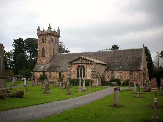
Dirleton Kirk
Dirleton Kirk is a church in the village of Dirleton, in East Lothian, Scotland. The church (at grid reference NT512842) is to the north of the village...
Dirleton
Dirleton is a village and civil parish in East Lothian, Scotland approximately 20 miles (32 km) east of Edinburgh on the A198. It contains 7,500 acres...

Archerfield Estate and Links
Archerfield and Archerfield Links are a country house (now hotel) and pair of golf courses in the parish of Dirleton, East Lothian, Scotland. An older...
Renaissance Club
The Renaissance Club is a golf club in Scotland, located in North Berwick, twenty miles (30 km) east of Edinburgh. It hosted the 2017 Scottish Senior Open...
Nearby Amenities
Located within 500m of 56.044555,-2.7848752Have you been to Hareup Plantation?
Leave your review of Hareup Plantation below (or comments, questions and feedback).