Birch Brae

Wood, Forest in Aberdeenshire

Scotland

Birch Brae

Cat Craigs Summit Cat Craigs 456m (Trump) 
Heather covering  the summit with no indication of the summit apart from nothing higher to stand on.
Cat Craigs Summit Credit: Ralph Greig

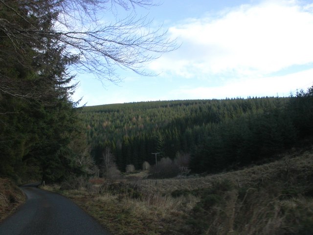
Birch Brae is a picturesque woodland located in Aberdeenshire, Scotland. This enchanting forest is renowned for its abundant birch trees, which dominate the landscape and give the area its name. Covering an area of approximately 100 acres, Birch Brae is a haven of tranquility and natural beauty.

The woodland is characterized by its dense canopy of slender birch trees that tower above the forest floor. These trees create a magical atmosphere, with their delicate leaves rustling in the gentle breeze. The interplay of sunlight filtering through the branches adds to the ethereal ambiance of the woodland.

Birch Brae is home to a diverse range of flora and fauna. The forest floor is carpeted with a variety of wildflowers, such as bluebells and primroses, which bloom in vibrant colors during the spring and summer months. The undergrowth is teeming with ferns and mosses, creating a lush and verdant understorey.

This woodland provides a habitat for a plethora of wildlife. Visitors to Birch Brae may spot red squirrels darting through the trees or catch a glimpse of roe deer grazing in the clearings. The woodland also attracts a variety of bird species, including woodpeckers and owls, making it a paradise for birdwatching enthusiasts.

Birch Brae is a popular destination for nature lovers and outdoor enthusiasts. The forest offers several well-maintained trails that wind through the woodland, providing opportunities for leisurely walks or invigorating hikes. The serene atmosphere and breathtaking scenery make Birch Brae an ideal location for those seeking refuge from the hustle and bustle of everyday life.

If you have any feedback on the listing, please let us know in the comments section below.

Birch Brae Images

Images are sourced within 2km of 57.3665/-2.8687085 or Grid Reference NJ4731. Thanks to Geograph Open Source API. All images are credited.

Cat Craigs Summit Cat Craigs 456m (Trump) 
Heather covering  the summit with no indication of the summit apart from nothing higher to stand on.
Cat Craigs Summit
Cat Craigs 456m (Trump) Heather covering the summit with no indication of the summit apart from nothing higher to stand on.
Road by Clashindarroch
Looking towards Tap o'Noth... ...some 3 km north-west of the Craw Stane.
Looking towards Tap o'Noth...
...some 3 km north-west of the Craw Stane.
Nearing the summit of Tap o' Noth
Path to the summit of Tap o' Noth
Heading up the hill... ...towards Tap o'Noth.
Heading up the hill...
...towards Tap o'Noth.
Deer fence and gate on the path to Tap o'Noth
Looking up at Tap o'Noth
Looking north from Tap o'Noth
Tap o'Noth It's a strenuous climb to the 563-m peak but the fascinating remains of the Iron Age hill fort and its vitrified fortifications (Canmore listing 1716: <span class="nowrap"><a title="https://canmore.org.uk/site/17169/tap-o-noth" rel="nofollow ugc noopener" href="https://canmore.org.uk/site/17169/tap-o-noth">Link</a><img style="margin-left:2px;" alt="External link" title="External link - shift click to open in new window" src="https://s1.geograph.org.uk/img/external.png" width="10" height="10"/></span> ) and the spectacular views for up to 50 km around are worth the effort.
Tap o'Noth
It's a strenuous climb to the 563-m peak but the fascinating remains of the Iron Age hill fort and its vitrified fortifications (Canmore listing 1716: LinkExternal link ) and the spectacular views for up to 50 km around are worth the effort.
Trig point at Tap o'Noth This is a 'secondary' trig point, reference number TP6317; for more on trig points, see: <span class="nowrap"><a title="https://en.wikipedia.org/wiki/Triangulation_station" rel="nofollow ugc noopener" href="https://en.wikipedia.org/wiki/Triangulation_station">Link</a><img style="margin-left:2px;" alt="External link" title="External link - shift click to open in new window" src="https://s1.geograph.org.uk/img/external.png" width="10" height="10"/></span> .   Scree and rubble from the remains of the walls of the iron Age hill fort can be seen in the foreground.
Trig point at Tap o'Noth
This is a 'secondary' trig point, reference number TP6317; for more on trig points, see: LinkExternal link . Scree and rubble from the remains of the walls of the iron Age hill fort can be seen in the foreground.
View towards Old Merdrum from Tap o' Noth Some of the fields in this photograph have now become forested especially to the south west of Old Merdrum.
View towards Old Merdrum from Tap o' Noth
Some of the fields in this photograph have now become forested especially to the south west of Old Merdrum.
Tap o' Noth - vitrified fort
Tap o'Noth Summit Tap o'Noth 563m (Marilyn)
The second highest  hill fort in Scotland
Tap o'Noth Summit
Tap o'Noth 563m (Marilyn) The second highest hill fort in Scotland
Tap o' Noth The path is buried but the view to The Buck spectacular
Tap o' Noth
The path is buried but the view to The Buck spectacular
Path climbing for Tap o' Noth The path here climbs on the west side of the hill, over grass and then on to the heather of the upper slopes.
Path climbing for Tap o' Noth
The path here climbs on the west side of the hill, over grass and then on to the heather of the upper slopes.
Hill fort and trig point on Tap o' Noth Many hill tops in the UK have the ancient earthworks of hill forts about their tops; the example at the top of this hill differs in that it is described as 'vitrified'. Rocks used to create the ramparts of the fort have been subjected to heat with the intention of fusing the component stones together. The effect, at least as observed by the photographer in the Tap o' Noth fort, is not that striking.
Hill fort and trig point on Tap o' Noth
Many hill tops in the UK have the ancient earthworks of hill forts about their tops; the example at the top of this hill differs in that it is described as 'vitrified'. Rocks used to create the ramparts of the fort have been subjected to heat with the intention of fusing the component stones together. The effect, at least as observed by the photographer in the Tap o' Noth fort, is not that striking.
Tap o' Noth
Tap o' Noth
Show me another place!

Birch Brae is located at Grid Ref: NJ4731 (Lat: 57.3665, Lng: -2.8687085)

Unitary Authority: Aberdeenshire

Police Authority: North East

What 3 Words

///managers.occupations.takers. Near Huntly, Aberdeenshire

Nearby Locations

Birch Brae

Related Wikis

Tap o' Noth

The Tap o' Noth is a hill and the name of a Pictish hill fort on its summit,8 miles south of Huntly in Aberdeenshire, Scotland at grid reference NJ485293...

Wormy Hillock Henge

Wormy Hillock Henge, also known as The Dragon's Grave, is a small henge in Aberdeenshire, Scotland. It is a Scheduled Ancient Monument located in the Clashindarroch...

Lesmoir Castle

Lesmoir Castle was a 16th-century castle, about 2.0 miles (3.2 km) west of Rhynie, Aberdeenshire, Scotland, south-west of Tap o' Noth, at Mains of Lesmoir...

A97 road

The A97 is a major road in Aberdeenshire, Scotland. A very short section of the road is within Moray == Route == It runs south from Banff on the north...

Nearby Amenities

Located within 500m of 57.3665,-2.8687085
Power: pole
Lat/Long: 57.3663972/-2.8731863
Power: pole
Lat/Long: 57.3662871/-2.8722333
Power: pole
Lat/Long: 57.3661957/-2.8714028
Power: pole
Lat/Long: 57.366056/-2.8702033
Power: pole
Lat/Long: 57.3659154/-2.8689661
Power: pole
Lat/Long: 57.3657749/-2.8677337
Power: pole
Lat/Long: 57.3658833/-2.8665106
Power: pole
Lat/Long: 57.3659908/-2.8652892
Power: pole
Lat/Long: 57.3661051/-2.8639908
Power: pole
Lat/Long: 57.3662211/-2.8626971
Power: pole
Lat/Long: 57.3664412/-2.8615337
Mytice
Place: hamlet
Lat/Long: 57.3662155/-2.8737585
The data included in this document is from www.openstreetmap.org. The data is made available under ODbL.

Have you been to Birch Brae?

Leave your review of Birch Brae below (or comments, questions and feedback).