Cefn-crib

Settlement in Monmouthshire

Wales

Cefn-crib

Demolition site, Hafod-yr-Ynys Road A row of houses has begun to be demolished because of the high concentration of nitrogen dioxide in the air. The remaining houses on Woodside Terrace, all purchased by Caerphilly Council, will all be demolished
Demolition site, Hafod-yr-Ynys Road Credit: M J Roscoe

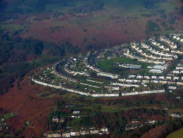
Cefn-crib is a small village located in the county of Monmouthshire, Wales. Situated in the eastern part of the county, it lies in the beautiful countryside surrounded by rolling hills and picturesque landscapes. The village is relatively remote, offering a peaceful and tranquil atmosphere for its residents.

With a population of around 300 people, Cefn-crib maintains a close-knit community feel. The village is known for its strong sense of community spirit and its active involvement in local events and initiatives. The residents often organize various social gatherings and fundraisers, fostering a warm and welcoming environment.

Despite its small size, Cefn-crib is not lacking in amenities. The village boasts a local pub, providing a gathering place for both residents and visitors. Additionally, there is a small convenience store that caters to the daily needs of the community.

Cefn-crib is also surrounded by an abundance of natural beauty, making it an ideal location for outdoor enthusiasts. The surrounding hills and countryside offer numerous opportunities for hiking, cycling, and exploring the great outdoors. The village is also within close proximity to the renowned Brecon Beacons National Park, offering further recreational activities and stunning landscapes.

In terms of transportation, Cefn-crib is easily accessible by road. The village is located just off the A465, providing convenient connections to neighboring towns and cities. The closest major town is Abergavenny, which is approximately 7 miles away.

Overall, Cefn-crib is a charming village in Monmouthshire that offers a close-knit community, beautiful surroundings, and a peaceful way of life.

If you have any feedback on the listing, please let us know in the comments section below.

Cefn-crib Images

Images are sourced within 2km of 51.684459/-3.1151908 or Grid Reference ST2399. Thanks to Geograph Open Source API. All images are credited.

Demolition site, Hafod-yr-Ynys Road A row of houses has begun to be demolished because of the high concentration of nitrogen dioxide in the air. The remaining houses on Woodside Terrace, all purchased by Caerphilly Council, will all be demolished
Demolition site, Hafod-yr-Ynys Road
A row of houses has begun to be demolished because of the high concentration of nitrogen dioxide in the air. The remaining houses on Woodside Terrace, all purchased by Caerphilly Council, will all be demolished
Houses ready for demolition, Hafod-yr-Ynys Road Row of terraced houses due to be demolished because of the high concentration of nitrogen dioxide in the air in the 'street canyon' in the valley. The green cabinet next to the telegraph pole houses the monitor of air pollutants.
Houses ready for demolition, Hafod-yr-Ynys Road
Row of terraced houses due to be demolished because of the high concentration of nitrogen dioxide in the air in the 'street canyon' in the valley. The green cabinet next to the telegraph pole houses the monitor of air pollutants.
House demolition site, Hafod-yr-Ynys Road All the houses on Woodside Terrace, purchased by Caerphilly Council, will be demolished because of severe air pollution on this busy cross-valley A road.
House demolition site, Hafod-yr-Ynys Road
All the houses on Woodside Terrace, purchased by Caerphilly Council, will be demolished because of severe air pollution on this busy cross-valley A road.
Sofa Sofa Looking towards the A467 at Crumlin from the furniture retailer's showroom.
Sofa Sofa
Looking towards the A467 at Crumlin from the furniture retailer's showroom.
Hafodyrynys Coal Washery The washery at Hafodyrynys contained equipment for extracting coal dust from slurry and drying the remaining waste before tipping: processes which were rare before the 1950s. It was built entirely of reinforced concrete with continuous glazed panels. The colliery closed in 1966 and the site was cleared in 1985, but the slimes thickener at the washery was retained at the request of Sir Richard Hanbury-Tenison of Pontypool Park Estate, to which the site reverted. Plans were drawn up at the time to adapt the building as a restaurant. Its futuristic use of reinforced concrete and the splendid isolation in which it now stands have made it a well-known landmark.
Hafodyrynys Coal Washery
The washery at Hafodyrynys contained equipment for extracting coal dust from slurry and drying the remaining waste before tipping: processes which were rare before the 1950s. It was built entirely of reinforced concrete with continuous glazed panels. The colliery closed in 1966 and the site was cleared in 1985, but the slimes thickener at the washery was retained at the request of Sir Richard Hanbury-Tenison of Pontypool Park Estate, to which the site reverted. Plans were drawn up at the time to adapt the building as a restaurant. Its futuristic use of reinforced concrete and the splendid isolation in which it now stands have made it a well-known landmark.
Ordnance Survey Cut Mark This OS cut mark can be found on the wall NE side of High Street. It marks a point 167.469m above mean sea level.
Ordnance Survey Cut Mark
This OS cut mark can be found on the wall NE side of High Street. It marks a point 167.469m above mean sea level.
Ordnance Survey Cut Mark This OS cut mark can be found on the old Pithead Baths. It marks a point 164.741m above mean sea level.
Ordnance Survey Cut Mark
This OS cut mark can be found on the old Pithead Baths. It marks a point 164.741m above mean sea level.
Path up from Llanhilleth Colliery Memorial Path on the edge of Granny's Wood from memorial <a href="https://www.geograph.org.uk/photo/7241714">SO2200 : Llanhilleth Colliery Memorial, Granny's Wood</a> to derelict pithead baths.
Path up from Llanhilleth Colliery Memorial
Path on the edge of Granny's Wood from memorial SO2200 : Llanhilleth Colliery Memorial, Granny's Wood to derelict pithead baths.
Path under road to Llanhilleth Colliery Memorial The path goes down from the derelict pithead baths under the High Street, B4471, at Horseshoe Bend into Granny's Wood and to the memorial <a href="https://www.geograph.org.uk/photo/7241714">SO2200 : Llanhilleth Colliery Memorial, Granny's Wood</a>.
Path under road to Llanhilleth Colliery Memorial
The path goes down from the derelict pithead baths under the High Street, B4471, at Horseshoe Bend into Granny's Wood and to the memorial SO2200 : Llanhilleth Colliery Memorial, Granny's Wood.
Path up to derelict pithead baths The path, the continuation of <a href="https://www.geograph.org.uk/photo/724165">SE1322 : Bridge at Cromwell Lock, Southowram</a>, goes from Granny's Wood under the High Street bridge <a href="https://www.geograph.org.uk/photo/7241678">SO2200 : Path under road to Llanhilleth Colliery Memorial</a>.
Path up to derelict pithead baths
The path, the continuation of SE1322 : Bridge at Cromwell Lock, Southowram, goes from Granny's Wood under the High Street bridge SO2200 : Path under road to Llanhilleth Colliery Memorial.
Llanhilleth Colliery Memorial, Granny's Wood The colliery, opened in 1892, closed in 1969 and the area between the High Street and the railway has reverted largely to woodland.
Llanhilleth Colliery Memorial, Granny's Wood
The colliery, opened in 1892, closed in 1969 and the area between the High Street and the railway has reverted largely to woodland.
Swffryd Swffryd from the air (this is the site of the original Crumlin viaduct, made famous by the film 'Arabesque' starring Gregory Peck and Sopia Loren). Thanks to Mike Hale for the info.
Swffryd
Swffryd from the air (this is the site of the original Crumlin viaduct, made famous by the film 'Arabesque' starring Gregory Peck and Sopia Loren). Thanks to Mike Hale for the info.
Crumlin, Caerphilly Disused Crumlin Navigation Colliery from Trinant Hall
Crumlin, Caerphilly
Disused Crumlin Navigation Colliery from Trinant Hall
Glyn Tunnel Eastern portal of the 280yd, single track Glyn tunnel on the former GW line between Hafodyrynys and Crumlin Jcn, photographed in 1980.  When the photo was taken the western portal had already been buried.  Subsequently, this end has also been infilled and buried beneath a whole lot of landscaping - which might excuse the poor quality of the photo, taken in early evening and a lot of Welsh weather!
Glyn Tunnel
Eastern portal of the 280yd, single track Glyn tunnel on the former GW line between Hafodyrynys and Crumlin Jcn, photographed in 1980. When the photo was taken the western portal had already been buried. Subsequently, this end has also been infilled and buried beneath a whole lot of landscaping - which might excuse the poor quality of the photo, taken in early evening and a lot of Welsh weather!
Power Lines
Power Lines
Forest edge, Ysgubor Wen
Road to Pen-y-caeau
Road to Pen-y-caeau
Bog grasses, near Ysgubor Wen
Show me another place!

Cefn-crib is located at Grid Ref: ST2399 (Lat: 51.684459, Lng: -3.1151908)

Unitary Authority: Torfaen

Police Authority: Gwent

What 3 Words

///sitting.rushed.escalates. Near Crumlin, Caerphilly

Nearby Locations

Cefn-crib

Related Wikis

Hafodyrynys

Hafodyrynys is a village on the A472 road between Pontypool and Crumlin in Caerphilly county borough, south-east Wales. It lies within the historic boundaries...

Hafodyrynys Platform railway station

Hafodyrynys Platform railway station was a station on the former Taff Vale Extension of the Newport, Abergavenny and Hereford Railway. It served the village...

Swffryd

Swffryd (or Sofrydd) is a Welsh community on the boundary of Blaenau Gwent County Borough Council. == Geography == The Ebbw River flows past the west...

Crumlin, Caerphilly

Crumlin (Welsh: Crymlyn) is a town, community and electoral ward in Caerphilly county borough in South Wales. It is situated in the Ebbw River valley,...

Crumlin Arm (Monmouthshire canal)

The Crumlin Arm of the Monmouthshire canal is part of the Monmouthshire & Brecon Canal network in South Wales. It connected Crumlin and its tramways to...

Crumlin Viaduct

The Crumlin Viaduct was a railway viaduct located above the village of Crumlin in South Wales, originally built to carry the Taff Vale Extension of the...

Ebbw Valley Railway

The Ebbw Valley Railway (Welsh: Rheilffordd Cwm Ebwy) is a branch line of the South Wales Main Line in South Wales. Transport for Wales Rail provides an...

Llanhilleth

Llanhilleth (from Welsh Llanheledd 'Church of Saint Heledd, the /i/ replacing the original /e/ due to the regional dialect of the area (Gwenhwyseg) changing...

Related Videos

Crumlin Navigation #shorts

Crumlin Navigation: https://youtu.be/Yvq57MmD5dk To donate and support our channel: ...

Wales.Blue lagoon. #travel #wales #cool#snow

From the parking lot you need to walk 3.5 km uphill and you come to a hot river where you can swim.

Hiking for Health - Blaencuffin Canyon

27/02/2022 - With so much on my mind it was time for another Hiking for Health adventure. I decided on another local mountain ...

Nearby Amenities

Located within 500m of 51.684459,-3.1151908
Crossing
Crossing: traffic_signals
Crossing Ref: pelican
Lat/Long: 51.6833556/-3.1192944
Fast Food
Happy Garden Fish Bar
Addr City: Hafodyrynys
Addr Postcode: NP11 5BD
Addr Street: Cefn Crib Road
Cuisine: fish_and_chips
Opening Hours: Mo 17:30-22:00; Tu off; We-Sa 17:30-23:00; Su 10:00-16:00,18:30-22:00
Opening Hours Covid19: Mo 17:30-22:00; Tu Off; We-Sa 17:30-23:00; Su 10:00-16:00,18:30-22:00
Phone: +44 1495 249 202
Website: https://en-gb.facebook.com/HappyGardenChineseTakeaway
Lat/Long: 51.6839512/-3.1185186
Pub
Hafodyrynys Inn
Addr City: Hafodyrynys
Addr Postcode: NP11 5BE
Addr Street: A472
Email: hafodinn1996@gmail.com
Opening Hours: Mo off; Tu-Sa 12:00-21:00; Su 12:30-14:30
Opening Hours Covid19: Mo Off; Tu-Sa 12:00-21:00; Su 12:30-14:30
Phone: +44 1495 243 010
Website: https://en-gb.facebook.com/hafodyrynys.inn
Wikidata: Q80583048
Lat/Long: 51.6838348/-3.1188835
Place Of Worship
Hafodyrynys Congregational Chapel
Addr City: Hafodyrynys
Addr Postcode: NP11 5BD
Addr Street: A472
Denomination: congregational
Phone: +44 1495 223 445
Religion: christian
Service Times: Su 11:00,18:00
Website: https://www.efcc.org.uk/church/hafodyrynys-congregational-church/
Lat/Long: 51.6841423/-3.1164499
Car Wash
Hafodyrynys hand Car Wash
Addr City: Hafodyrynys
Addr Postcode: NP11 5BD
Addr Street: A472
Lat/Long: 51.6839378/-3.1157232
(closed)
Historic Amenity: pub
Lat/Long: 51.6869094/-3.1102221
Post Box
Brand: Royal Mail
Brand Wikidata: Q638098
Mapillary: 1980155109008178
Operator: Royal Mail
Operator Wikidata: Q638098
Post Box Mounting: pier
Post Box Type: lamp
Survey Date: 2023-08-19
Lat/Long: 51.6838481/-3.1183375
Hafodyrynys
Place: village
Wikidata: Q5638416
Wikipedia: en:Hafodyrynys
Lat/Long: 51.6841781/-3.119475
Direction: SE
Generator Method: photovoltaic
Generator Output Electricity: yes
Generator Solar Modules: 16
Generator Source: solar
Generator Type: solar_photovoltaic_panel
Location: roof
Power: generator
Lat/Long: 51.6876196/-3.1183878
Direction: 255
Generator Method: photovoltaic
Generator Output Electricity: yes
Generator Solar Modules: 22
Generator Source: solar
Generator Type: solar_photovoltaic_panel
Location: roof
Power: generator
Lat/Long: 51.6857057/-3.1189816
Direction: 185
Generator Method: photovoltaic
Generator Output Electricity: yes
Generator Solar Modules: 12
Generator Source: solar
Generator Type: solar_photovoltaic_panel
Location: roof
Power: generator
Lat/Long: 51.6867582/-3.1106114
Bus Stop
Bench: yes
Bus: yes
Departures Board: timetable
Level: 0
Lit: yes
Naptan AtcoCode: 5540AWB32623
Naptan NaptanCode: cpydagj
Network: Stagecoach South Wales
Operator: Stagecoach South Wales
Public Transport: platform
Shelter: yes
Lat/Long: 51.68381/-3.1184672
Bus Stop
Bench: yes
Bus: yes
Departures Board: timetable
Level: 0
Lit: yes
Naptan AtcoCode: 5540AWB32622
Naptan NaptanCode: cpydagd
Network: Stagecoach South Wales
Operator: Stagecoach South Wales
Public Transport: platform
Shelter: yes
Lat/Long: 51.6835813/-3.1185174
The data included in this document is from www.openstreetmap.org. The data is made available under ODbL.

Have you been to Cefn-crib?

Leave your review of Cefn-crib below (or comments, questions and feedback).