Campdalemore Wood

Wood, Forest in Banffshire

Scotland

Campdalemore Wood

Tomintoul The long narrow village of Tomintoul was founded in the 18th century to provide housing and work for weavers. Beyond the village is Carn Daimh, and beyond that again is Ben Rinnes, capped with snow. The other snow-capped hill is Corryhabbie.
Tomintoul Credit: Anne Burgess

Campdalemore Wood is a picturesque forest located in Banffshire, Scotland. Covering an area of approximately 200 acres, this woodland is known for its diverse flora and fauna, making it a popular destination for nature enthusiasts and hikers alike.

The wood is situated on the outskirts of the small village of Campdalemore, offering visitors a tranquil and serene environment. It is surrounded by rolling hills and stunning landscapes, adding to its natural beauty. The forest is easily accessible, with well-maintained paths and trails that guide visitors through its enchanting wilderness.

One of the key features of Campdalemore Wood is its rich biodiversity. The forest is home to a wide variety of plant species, including towering Scots pine trees, birch, oak, and rowan. This diverse range of vegetation provides a habitat for numerous animal species, such as red squirrels, badgers, and various bird species.

The wood offers a range of recreational activities for visitors to enjoy. Walking and hiking trails wind through the forest, allowing visitors to explore its hidden treasures. There are also designated picnic areas and viewpoints where visitors can relax and admire the stunning surroundings. Additionally, the wood has a designated camping area for those who wish to spend a night under the stars.

Campdalemore Wood is a true gem in the heart of Banffshire. Its natural beauty, diverse wildlife, and tranquil atmosphere make it an ideal destination for nature lovers and those seeking a peaceful retreat amidst the Scottish countryside.

If you have any feedback on the listing, please let us know in the comments section below.

Campdalemore Wood Images

Images are sourced within 2km of 57.262595/-3.3949743 or Grid Reference NJ1519. Thanks to Geograph Open Source API. All images are credited.

Tomintoul The long narrow village of Tomintoul was founded in the 18th century to provide housing and work for weavers. Beyond the village is Carn Daimh, and beyond that again is Ben Rinnes, capped with snow. The other snow-capped hill is Corryhabbie.
Tomintoul
The long narrow village of Tomintoul was founded in the 18th century to provide housing and work for weavers. Beyond the village is Carn Daimh, and beyond that again is Ben Rinnes, capped with snow. The other snow-capped hill is Corryhabbie.
Tomintoul Tomintoul (pronounce it 'Tom in towel' not 'Tom in tool') is typical of the planned villages of the 18th and 19th century in having a rectangular layout of parallel streets, and happily has escaped vandalism in the form of 20th or 21st century housing estate layouts. The Conglass Water, on the far side of the village, is a classic example of a meandering river.
Tomintoul
Tomintoul (pronounce it 'Tom in towel' not 'Tom in tool') is typical of the planned villages of the 18th and 19th century in having a rectangular layout of parallel streets, and happily has escaped vandalism in the form of 20th or 21st century housing estate layouts. The Conglass Water, on the far side of the village, is a classic example of a meandering river.
Across a marshy plain towards Tomintoul Tomintoul is reputed to be the highest village in the Highlands [but considerably lower than the highest in the Southern Uplands] and occupies a relatively flat site between the Conglass Water, seen here in the foreground, and the River Avon on the far side of the village. The site is not only high, but exposed, with the snow streaked Cairngorms in the distance.
Across a marshy plain towards Tomintoul
Tomintoul is reputed to be the highest village in the Highlands [but considerably lower than the highest in the Southern Uplands] and occupies a relatively flat site between the Conglass Water, seen here in the foreground, and the River Avon on the far side of the village. The site is not only high, but exposed, with the snow streaked Cairngorms in the distance.
Across the Square in Tomintoul A planned 18th century village laid out by the Duke of Gordon. One would suspect that the inhabitants must be a hardy bunch as it is a rather draughty place 345m above sea level in an open area.
Across the Square in Tomintoul
A planned 18th century village laid out by the Duke of Gordon. One would suspect that the inhabitants must be a hardy bunch as it is a rather draughty place 345m above sea level in an open area.
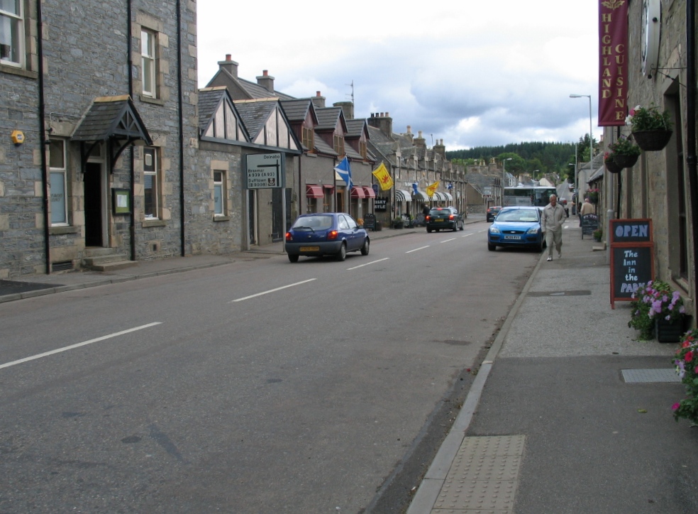
Main Street, Tomintoul Sloping gently downhill to the north west. The village was laid out on a grid plan dating from 1775.
Main Street, Tomintoul
Sloping gently downhill to the north west. The village was laid out on a grid plan dating from 1775.
Richmond Hotel, Tomintoul
The Smugglers Hostel, Tomintoul The 'Highest Hostel in the Scottish Highlands'
The Smugglers Hostel, Tomintoul
The 'Highest Hostel in the Scottish Highlands'
The Clockhouse Restaurant, Tomintoul
A939 at Bridge of Avon
The Clockhouse Restaurant, Tomintoul
Parking area below Campdalemore Wood Campdalemore Wood is on the slope rising to the north of the parking space which itself is just north of Tomintoul on the A939.
(Note: A farm, Campdalmore, is named on OS maps spelled that way; Campdalemore Wood is spelled differently. Perhaps in error?)
Parking area below Campdalemore Wood
Campdalemore Wood is on the slope rising to the north of the parking space which itself is just north of Tomintoul on the A939. (Note: A farm, Campdalmore, is named on OS maps spelled that way; Campdalemore Wood is spelled differently. Perhaps in error?)
View through the viewpoint
Fodderletter Lum
Fodderletter Lum
Conglass Water downstream The Conglass Water just north of a footbridge carrying the Speyside Way over its flow.
Cnoc Lochy is the hill rising beyond.
Conglass Water downstream
The Conglass Water just north of a footbridge carrying the Speyside Way over its flow. Cnoc Lochy is the hill rising beyond.
Croughly A farmhouse and some smaller outbuildings: the main, industrial-scale barns appear to be further along the minor road which passes the farm.
Croughly
A farmhouse and some smaller outbuildings: the main, industrial-scale barns appear to be further along the minor road which passes the farm.
Change of direction of Speyside Way The green-painted signpost indicates the change. The route has followed the minor road above the valley of the Gonglass Water and turns to climb away from it to the east. The hill across the valley is Cnoc Lochy.
Change of direction of Speyside Way
The green-painted signpost indicates the change. The route has followed the minor road above the valley of the Gonglass Water and turns to climb away from it to the east. The hill across the valley is Cnoc Lochy.
B9136 near Bridge of Avon
Tomintoul Post Office
Show me another place!

Campdalemore Wood is located at Grid Ref: NJ1519 (Lat: 57.262595, Lng: -3.3949743)

Unitary Authority: Moray

Police Authority: North East

What 3 Words

///chipper.skippers.melts. Near Grantown-on-Spey, Highland

Nearby Locations

Campdalemore Wood

Related Wikis

Tomintoul

Tomintoul ( ; from Scottish Gaelic: Tom an t-Sabhail, meaning "Hillock of the Barn") is a village in the Moray council area of Scotland in the historic...

Glenlivet Estate

The Glenlivet Estate is located in Glenlivet, Scotland in the Cairngorms National Park. It measures 58,000 acres (230 km2) and is part of The Crown Estate...

Kirkmichael, Moray

Kirkmichael is a parish and hamlet in Moray, Scotland. Kirkmichael was historically part of Banffshire.The hamlet lies approximately 8 miles south of Ballindalloch...

Tomintoul distillery

Tomintoul distillery is a distillery in Kirkmichael, between Ballindalloch and Tomintoul in the Speyside region of Scotland, producing malt whisky for...

Nearby Amenities

Located within 500m of 57.262595,-3.3949743
Power: pole
Lat/Long: 57.2621581/-3.4029189
Power: pole
Lat/Long: 57.261608/-3.4018988
Power: pole
Lat/Long: 57.2610738/-3.4014306
Power: pole
Lat/Long: 57.2604515/-3.4008406
Power: pole
Lat/Long: 57.2599244/-3.4003621
Power: pole
Lat/Long: 57.2595085/-3.3999952
Power: pole
Lat/Long: 57.2588885/-3.3994477
Power: pole
Lat/Long: 57.2639678/-3.4026752
Power: pole
Lat/Long: 57.2643456/-3.4016713
Power: pole
Lat/Long: 57.2647218/-3.4006468
Power: pole
Lat/Long: 57.2650821/-3.3996312
Power: pole
Lat/Long: 57.2655171/-3.3985127
Power: pole
Lat/Long: 57.2659266/-3.3974119
Power: pole
Lat/Long: 57.2662774/-3.3963698
Power: pole
Lat/Long: 57.2666631/-3.395316
Power: pole
Lat/Long: 57.2670615/-3.3943121
The data included in this document is from www.openstreetmap.org. The data is made available under ODbL.

Have you been to Campdalemore Wood?

Leave your review of Campdalemore Wood below (or comments, questions and feedback).