Aberbrân

Settlement in Brecknockshire

Wales

Aberbrân

Llwybr i Aberbran / Path to Aberbran Llwybr ceffyl yn dod i lawr o'r ucheldir i gyfeiriad pentre Aberbran.

A bridleway descends the hill in the direction of Aberbran village (trans. confluence of the crow stream).
Llwybr i Aberbran / Path to Aberbran Credit: Alan Richards

Aberbrân is a small village located in the historic county of Brecknockshire, situated in the southern part of Wales, United Kingdom. Nestled in the beautiful Brecon Beacons National Park, Aberbrân boasts stunning natural surroundings and a rich cultural heritage.

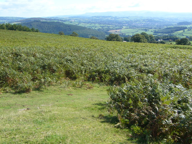
The village is set along the banks of the River Usk, which meanders through the picturesque countryside. It is known for its charming stone cottages, which add to its quaint and peaceful atmosphere. The landscape surrounding Aberbrân is dominated by rolling hills, lush green fields, and dense woodlands, making it an ideal destination for outdoor enthusiasts and nature lovers.

Aberbrân is renowned for its outdoor recreational activities, particularly hiking and walking. The village serves as a starting point for many scenic trails, including the popular Usk Valley Walk and the Taff Trail. These routes offer breathtaking views of the surrounding mountains and valleys, making them a haven for walkers and cyclists alike.

In terms of amenities, Aberbrân offers a limited range of facilities, including a local pub and a small convenience store. However, the nearby town of Brecon, which is approximately six miles away, provides a wider range of services, including shops, restaurants, and schools.

Overall, Aberbrân is a tranquil and idyllic village, offering a peaceful retreat for those seeking a break from the hustle and bustle of city life. Its stunning natural beauty and proximity to the Brecon Beacons National Park make it a popular destination for outdoor enthusiasts and tourists looking to explore the Welsh countryside.

If you have any feedback on the listing, please let us know in the comments section below.

Aberbrân Images

Images are sourced within 2km of 51.955086/-3.480075 or Grid Reference SN9829. Thanks to Geograph Open Source API. All images are credited.
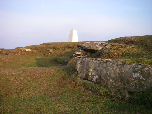
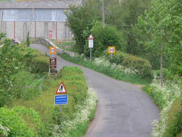
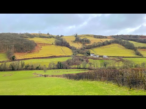
Llwybr i Aberbran / Path to Aberbran Llwybr ceffyl yn dod i lawr o'r ucheldir i gyfeiriad pentre Aberbran.

A bridleway descends the hill in the direction of Aberbran village (trans. confluence of the crow stream).
Llwybr i Aberbran / Path to Aberbran
Llwybr ceffyl yn dod i lawr o'r ucheldir i gyfeiriad pentre Aberbran. A bridleway descends the hill in the direction of Aberbran village (trans. confluence of the crow stream).
Llwybr ger Toryffynnon / Path near Toryffynnon Llwybr ceffyl yn mynd i lawr y waered ger anhedd-dy o'r enw Toryffynnon.

A bridleway descends the hill near a property known as Toryffynnon
Llwybr ger Toryffynnon / Path near Toryffynnon
Llwybr ceffyl yn mynd i lawr y waered ger anhedd-dy o'r enw Toryffynnon. A bridleway descends the hill near a property known as Toryffynnon
Llwybr i'r mynydd / Path to the hill Llwybr ceffyl yn agosau at Fynydd Aberysgir.

A bridleway approaches Mynydd Aberysgir (trans. mountain of the river Yscir confluence).
Llwybr i'r mynydd / Path to the hill
Llwybr ceffyl yn agosau at Fynydd Aberysgir. A bridleway approaches Mynydd Aberysgir (trans. mountain of the river Yscir confluence).
Mynydd Aberysgir Gât yn rhoi mynediad i gomin Fynydd Aberysgir.

A gate gives access to a common known as Mynydd Aberysgir (trans. mountain of the river Yscir confluence).
Mynydd Aberysgir
Gât yn rhoi mynediad i gomin Fynydd Aberysgir. A gate gives access to a common known as Mynydd Aberysgir (trans. mountain of the river Yscir confluence).
Mynydd Aberysgir Llwybr ceffyl ar dir comin a elwir Mynydd Aberysgir.

A bridleway on common land known as Mynydd Aberysgir (trans. mountain of the river Yscir confluence).
Mynydd Aberysgir
Llwybr ceffyl ar dir comin a elwir Mynydd Aberysgir. A bridleway on common land known as Mynydd Aberysgir (trans. mountain of the river Yscir confluence).
Mynydd Aberysgir Llwybr yn croesi comin a elwir Mynydd Aberysgir.

A path crosses a common known as Mynydd Aberysgir (trans. mountain of the river Yscir confluence).
Mynydd Aberysgir
Llwybr yn croesi comin a elwir Mynydd Aberysgir. A path crosses a common known as Mynydd Aberysgir (trans. mountain of the river Yscir confluence).
Heol fach wledig / A minor rural road Heol fach wledig yn mynd i gyfeiriad Aberbran. Y ddwy gopa yn y pellter yw Pen y Fan a Chorn. Du.  Hen enw  arnynt oedd Cadair Arthur.

A minor rural road heading towards Aberbran (trans. confluence of the river Brân [crow]). The twin peaks in the distance are Pen y Fan and Corn Du.  An old name for the peaks is Cadair Arthur (trans. Arthur's Chair).
Heol fach wledig / A minor rural road
Heol fach wledig yn mynd i gyfeiriad Aberbran. Y ddwy gopa yn y pellter yw Pen y Fan a Chorn. Du. Hen enw arnynt oedd Cadair Arthur. A minor rural road heading towards Aberbran (trans. confluence of the river Brân [crow]). The twin peaks in the distance are Pen y Fan and Corn Du. An old name for the peaks is Cadair Arthur (trans. Arthur's Chair).
Road to Llanfihangel Nant Bran Great care needed by all in this section of bending narrow road with no viewing over the tall hedging
Road to Llanfihangel Nant Bran
Great care needed by all in this section of bending narrow road with no viewing over the tall hedging
Road from Llanfihangel Nant Bran through Coed Drysiog
Road from Cradoc entering Aberyscir
Twyn-y-Gaer trig
Twyn-y-Gaer trig
Bracken on Twyn-Y-Gaer
Summit rocks of Twyn y Gaer The sandstone bedrock at the 367m high summit of Twyn y Gaer has been quarried away in the past - possibly when the site was occupied during the Iron Age?
Summit rocks of Twyn y Gaer
The sandstone bedrock at the 367m high summit of Twyn y Gaer has been quarried away in the past - possibly when the site was occupied during the Iron Age?
Pillow mound at Twyn y Gaer This long low L-shaped earthen mound is one of several on the flanks of this hillfort which is interpreted as a pillow mound.  Dating from the 19th century they were provided for rabbits to burrow into as a number of fur farms were established in the area.
Pillow mound at Twyn y Gaer
This long low L-shaped earthen mound is one of several on the flanks of this hillfort which is interpreted as a pillow mound. Dating from the 19th century they were provided for rabbits to burrow into as a number of fur farms were established in the area.
High pressure gas main The 1220 mm diameter pipe can be seen here before it is buried.
High pressure gas main
The 1220 mm diameter pipe can be seen here before it is buried.
A40 past Abercamlais Just passing the turning to Abercamlais and looking East along the A40 towards Penpont. The river which flows under the A40 at the dip in the road is the Cwm Camlais.
A40 past Abercamlais
Just passing the turning to Abercamlais and looking East along the A40 towards Penpont. The river which flows under the A40 at the dip in the road is the Cwm Camlais.
Aber-Bran Bridge Aber-Bran Bridge over the River Usk (Afon Wysg) with Aberbran Fach Farmbuildings beyond.
Aber-Bran Bridge
Aber-Bran Bridge over the River Usk (Afon Wysg) with Aberbran Fach Farmbuildings beyond.
Show me another place!

Aberbrân is located at Grid Ref: SN9829 (Lat: 51.955086, Lng: -3.480075)

Unitary Authority: Powys

Police Authority: Dyfed Powys

What 3 Words

///today.gent.smothered. Near Brecon, Powys

Nearby Locations

Aberbrân

Related Wikis

Aberbrân

Aberbrân is a small settlement in Powys, Wales. It lies on the Afon Brân immediately above its confluence (Welsh 'aber') with the River Usk and is 7 kilometres...

Aberbran railway station

Aberbran railway station served the village of Aberbran in the traditional county of Brecknockshire, Wales. == History == Opened by the Neath and Brecon...

Nant Brân

The Nant Brân is a short river which rises on the southern slopes of Mynydd Epynt in Powys, Wales. The word 'brân' means 'crow' in Welsh: the name may...

Penpont Manor House

Penpont is a seventeenth-century Grade I listed manor house in the Usk valley between Brecon and Sennybridge in Powys, Wales. It was built by Daniel Williams...

Related Videos

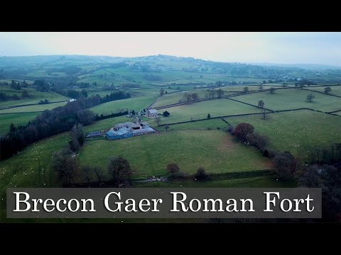
How the Mighty Have Fallen- Brecon Gaer Roman Fort

Cadw states that Brecon Gaer Roman Fort "was once one of the Romans' largest inland forts and a vital link in the occupiers' ...

Cycle route from Aberbran Club Campsite

Jonathan Manning battles the conditions and the gradient on a challenging ride in the Brecon Beacons from the Aberbran Club ...

Horse Riding Fun at Penpont House | Summer Holidays

penpont #Horses #Brecon Beautiful memories at Penpont house and Horse Riding fun.

Nearby Amenities

Located within 500m of 51.955086,-3.480075
Aberbran
Historic Railway: station
Railway: site
Wikidata: Q4666789
Wikipedia: en:Aberbran railway station
Lat/Long: 51.954192/-3.480408
Aberbran
Name Cy: Aberbrân
Place: hamlet
Source: GPS
Wikidata: Q3405008
Lat/Long: 51.9554007/-3.4780294
Post Box
Post Box Type: lamp
Ref: LD3 365
Royal Cypher: EIIR
Royal Cypher Wikidata: Q33102113
Lat/Long: 51.9553668/-3.4790723
Place: farm
Lat/Long: 51.9524976/-3.4765651
Shelter
Shelter Type: public_transport
Lat/Long: 51.9553152/-3.4790269
Telephone
Booth: K6
Covered: booth
Operator: BT
Phone: +44 1874 622238
Lat/Long: 51.9554331/-3.4790913
The data included in this document is from www.openstreetmap.org. The data is made available under ODbL.

Have you been to Aberbrân?

Leave your review of Aberbrân below (or comments, questions and feedback).