Gardners Wood

Wood, Forest in Midlothian

Scotland

Gardners Wood

Gogar Bridge Bridge over the Gogar Burn about 2 km from its source on Corston Hill. The road is the unclassified road from the A70 Lang Whang north to Ormiston.
Gogar Bridge Credit: M J Richardson

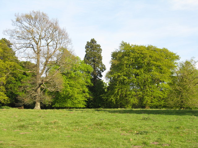
Gardners Wood is a picturesque forest located in Midlothian, Scotland. Covering an area of approximately 150 acres, it is a popular destination for nature lovers and outdoor enthusiasts. Situated just a few miles outside the city of Edinburgh, it offers a peaceful retreat from the hustle and bustle of urban life.

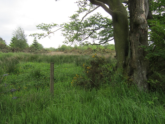
The woodland is characterized by a diverse range of tree species, including oak, birch, beech, and Scots pine. The dense canopy provides ample shade and creates a cool and tranquil atmosphere throughout the year. The forest floor is covered with a rich carpet of moss, ferns, and wildflowers, adding to its natural beauty.

Gardners Wood is home to a variety of wildlife, making it a haven for nature enthusiasts. Visitors may encounter red squirrels, roe deer, and a wide array of bird species, including woodpeckers and owls. The forest also supports a thriving population of butterflies and insects.

The wood offers a network of well-maintained trails, allowing visitors to explore its natural wonders on foot or by bike. There are also designated picnic areas and benches, providing visitors with the opportunity to relax and enjoy the tranquil surroundings. Interpretive signs throughout the forest provide educational information about the flora and fauna found within the wood.

Gardners Wood is a fantastic destination for individuals seeking to reconnect with nature and enjoy the beauty of the Scottish countryside. Whether it's a leisurely stroll or a more adventurous hike, this woodland offers something for everyone, making it a must-visit location in Midlothian.

If you have any feedback on the listing, please let us know in the comments section below.

Gardners Wood Images

Images are sourced within 2km of 55.881649/-3.4197507 or Grid Reference NT1166. Thanks to Geograph Open Source API. All images are credited.

Gogar Bridge Bridge over the Gogar Burn about 2 km from its source on Corston Hill. The road is the unclassified road from the A70 Lang Whang north to Ormiston.
Gogar Bridge
Bridge over the Gogar Burn about 2 km from its source on Corston Hill. The road is the unclassified road from the A70 Lang Whang north to Ormiston.
Shelter belt from Burnbrae Looking across pasture and mole hills from near the entrance to Selm Muir Forest on Leyden Road.
Shelter belt from Burnbrae
Looking across pasture and mole hills from near the entrance to Selm Muir Forest on Leyden Road.
Burnbrae from Leyden Road A small farm between Selmmuir Forest and Kirknewton.
Burnbrae from Leyden Road
A small farm between Selmmuir Forest and Kirknewton.
Parkland trees at Easter Newton Presumably a legacy of Kirknewton House, which is shown on the map to have a large area of estate to the east.
Parkland trees at Easter Newton
Presumably a legacy of Kirknewton House, which is shown on the map to have a large area of estate to the east.
Solar panels at Easter Newton A large domestic array of solar panels adjacent to a house at Easter Newton, and protection for a newly planted hedge.
Solar panels at Easter Newton
A large domestic array of solar panels adjacent to a house at Easter Newton, and protection for a newly planted hedge.
Parkland trees near Kirknewton Near Easter Newton farm, and presumably part of the grounds of Kirknewton House at some time in the past.
Parkland trees near Kirknewton
Near Easter Newton farm, and presumably part of the grounds of Kirknewton House at some time in the past.
Energy gathering at Easter Newton Two trees [oak and beech[?]], and a bank of solar panels.
Energy gathering at Easter Newton
Two trees [oak and beech[?]], and a bank of solar panels.
Electricity sub-station at Easter Newton
Cottage at Kirknewton In need of further attention - considerable deterioration in three years - see <a href="https://www.geograph.org.uk/photo/1049885">NT1067 : Cottage in need of attention</a> for comparison.
Cottage at Kirknewton
In need of further attention - considerable deterioration in three years - see NT1067 : Cottage in need of attention for comparison.
Entrance to Kirknewton
A wet edge to a field Not the best drainage at this side of a large field by Linburn.
A wet edge to a field
Not the best drainage at this side of a large field by Linburn.
Cow and calf, Kirknewton The field runs steeply down from the Edinburgh to Carlisle railway. It is grassland not a wood as is mapped by the Ordnance Survey.
Cow and calf, Kirknewton
The field runs steeply down from the Edinburgh to Carlisle railway. It is grassland not a wood as is mapped by the Ordnance Survey.
A burn near Kirknewton Cattle beside a small burn, east of Kirknewton.
A burn near Kirknewton
Cattle beside a small burn, east of Kirknewton.
Main Street, Kirknewton
B7031 runs through Greenburn Wood Woodland near Kirknewton.
B7031 runs through Greenburn Wood
Woodland near Kirknewton.
RAF Kirknewton An airfield on boggy ground beneath the Pentland Hills. It is used for training with gliders, but there are often helicopters about.  There is talk of using the site to build a new army base replacing the Edinburgh barracks.
RAF Kirknewton
An airfield on boggy ground beneath the Pentland Hills. It is used for training with gliders, but there are often helicopters about. There is talk of using the site to build a new army base replacing the Edinburgh barracks.
A newly ploughed field The field is between the A70 Lang Whang road and the Water of Leith.
A newly ploughed field
The field is between the A70 Lang Whang road and the Water of Leith.
Fox Covert A very wet woodland.
Fox Covert
A very wet woodland.
Show me another place!

Gardners Wood is located at Grid Ref: NT1166 (Lat: 55.881649, Lng: -3.4197507)

Unitary Authority: West Lothian

Police Authority: The Lothians and Scottish Borders

What 3 Words

///poses.bills.firepower. Near Kirknewton, West Lothian

Related Wikis

Kirknewton, West Lothian

Kirknewton (Scots: Kirknewtoun, Scottish Gaelic: Eaglais a' Bhaile Ùir) is a village formerly in the county of Midlothian and, since 1975, in West Lothian...

Ritchie Camp

Ritchie Camp was a military base located near Kirknewton, West Lothian in Scotland. == History == Ritchie Camp was initially established during World War...

Kirknewton railway station

Kirknewton railway station is a railway station serving the village of Kirknewton in West Lothian, Scotland, Opened as Kirknewton in February 1848, the...

RAF Kirknewton

Royal Air Force Kirknewton, otherwise known as RAF Kirknewton, is a Royal Air Force station at Whitemoss, a mile south east of Kirknewton, West Lothian...

Nearby Amenities

Located within 500m of 55.881649,-3.4197507
Power: pole
Lat/Long: 55.8828697/-3.4274555
Power: pole
Lat/Long: 55.8833062/-3.4260043
Power: pole
Lat/Long: 55.8837393/-3.423628
Power: pole
Lat/Long: 55.8842577/-3.4210731
Power: pole
Lat/Long: 55.8853956/-3.4163914
Power: pole
Lat/Long: 55.8846028/-3.4186632
Power: pole
Lat/Long: 55.8843922/-3.4197764
Power: pole
Lat/Long: 55.8831691/-3.4260742
Power: pole
Lat/Long: 55.8839695/-3.422244
Power: pole
Lat/Long: 55.8848211/-3.4175527
Power: pole
Lat/Long: 55.8827825/-3.427249
Power: pole
Lat/Long: 55.8849098/-3.4176224
Power: pole
Lat/Long: 55.8834987/-3.4248805
Power: pole
Lat/Long: 55.8833873/-3.4248913
Power: pole
Lat/Long: 55.8838041/-3.4236949
Power: pole
Lat/Long: 55.8854708/-3.4164612
Power: pole
Lat/Long: 55.8844689/-3.4198541
Power: pole
Lat/Long: 55.8841816/-3.4210102
Power: pole
Lat/Long: 55.8846751/-3.4187624
Power: pole
Lat/Long: 55.8840597/-3.4223352
Recycling
Location: overground
Recycling Glass: yes
Recycling Type: container
Lat/Long: 55.8860757/-3.4198388
Power: pole
Lat/Long: 55.8835904/-3.4161392
Power: pole
Lat/Long: 55.8841274/-3.4160641
Power: pole
Lat/Long: 55.8847623/-3.4159809
Power: pole
Lat/Long: 55.8854016/-3.4159407
Power: pole
Lat/Long: 55.8790387/-3.4135082
The data included in this document is from www.openstreetmap.org. The data is made available under ODbL.

Have you been to Gardners Wood?

Leave your review of Gardners Wood below (or comments, questions and feedback).