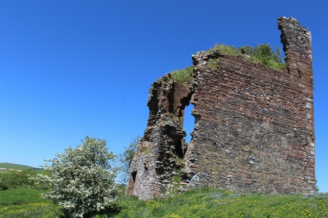
Bank Plantation

Wood, Forest in Dumfriesshire

Scotland

Bank Plantation

Old Milestone by the A709, Torthorwald Parish By the A709, in parish of Torthorwald (Nithsdale District), Torthorwald, West of village sign, North side of road.

Inscription reads:- : LOCKERBY / 8½ {arrow} / DUMFRIES / {arrow} 4 : 

Surveyed

Milestone Society National ID: DG_DFLB04
Old Milestone by the A709, Torthorwald Parish Credit: Gail Fawcett

Bank Plantation is a sprawling woodland located in Dumfriesshire, Scotland. Covering an area of approximately 500 acres, it is known for its dense and diverse forest vegetation. The plantation is situated near the village of Bankshill, offering a tranquil retreat for nature enthusiasts and outdoor adventurers alike.

The woodland is predominantly composed of native tree species such as oak, birch, and beech, creating a vibrant and ecologically rich environment. The trees tower above, forming a dense canopy that provides ample shade and shelter for a variety of wildlife.

Bank Plantation is home to a wide range of animal species, including red squirrels, badgers, and roe deer. Bird enthusiasts will also find delight in the presence of woodland birds such as woodpeckers, owls, and various songbirds.

For outdoor enthusiasts, Bank Plantation offers a network of well-maintained trails that wind through the woods, allowing visitors to explore the natural beauty at their own pace. These trails are suitable for both hiking and cycling, offering opportunities for exercise and enjoyment amidst the serene surroundings.

In addition to its recreational value, Bank Plantation also serves as an important carbon sink, contributing to the reduction of greenhouse gas emissions and mitigating the effects of climate change.

Overall, Bank Plantation in Dumfriesshire is a stunning woodland that offers a peaceful escape into nature. With its diverse flora and fauna, it provides a habitat for wildlife and a haven for outdoor enthusiasts seeking solace in the beauty of the forest.

If you have any feedback on the listing, please let us know in the comments section below.

Bank Plantation Images

Images are sourced within 2km of 55.090257/-3.508849 or Grid Reference NY0378. Thanks to Geograph Open Source API. All images are credited.

Old Milestone by the A709, Torthorwald Parish By the A709, in parish of Torthorwald (Nithsdale District), Torthorwald, West of village sign, North side of road.

Inscription reads:- : LOCKERBY / 8½ {arrow} / DUMFRIES / {arrow} 4 : 

Surveyed

Milestone Society National ID: DG_DFLB04
Old Milestone by the A709, Torthorwald Parish
By the A709, in parish of Torthorwald (Nithsdale District), Torthorwald, West of village sign, North side of road. Inscription reads:- : LOCKERBY / 8½ {arrow} / DUMFRIES / {arrow} 4 : Surveyed Milestone Society National ID: DG_DFLB04
High Road, Torthorwald
Torthorwald Castle
Torthorwald Castle
The cruck-framed cottage, Torthorwald
Minor road near Torthorwald
Minor road through Torthorwald
Road junction at Roucan
Approaching cross roads at Roucan
A709 entering Torthorwald
A709 through Torthorwald From Torr garage services
A709 through Torthorwald
From Torr garage services
Approaching Branetrigg entrance Footpath sign can be seen on the left
Approaching Branetrigg entrance
Footpath sign can be seen on the left
A709 approaching Belridding junction
Torthorwald Parish Church Category B-listed. Dated 1782.
Torthorwald Parish Church
Category B-listed. Dated 1782.
Torthorwald Castle Dates from the 14th century. Abandoned around 1715.
Torthorwald Castle
Dates from the 14th century. Abandoned around 1715.
Torthorwald Castle Dates from the 14th century. Abandoned around 1715.
Torthorwald Castle
Dates from the 14th century. Abandoned around 1715.
Cruck-framed Cottage, Torthorwald Category A-listed. Rebuilt early 19th century and restored in the 1990s.
Cruck-framed Cottage, Torthorwald
Category A-listed. Rebuilt early 19th century and restored in the 1990s.
Stubble, Branetrigg
Stubble, Branetrigg
Fields, Branetrigg Grass, either side of the Torthorwald Burn.
Fields, Branetrigg
Grass, either side of the Torthorwald Burn.
Show me another place!

Bank Plantation is located at Grid Ref: NY0378 (Lat: 55.090257, Lng: -3.508849)

Unitary Authority: Dumfries and Galloway

Police Authority: Dumfries and Galloway

What 3 Words

///segmented.obey.linked. Near Locharbriggs, Dumfries & Galloway

Related Wikis

Torthorwald

Torthorwald is a village and civil parish in Dumfries and Galloway, south-west Scotland. It is located 6 kilometres (3.7 mi) east of Dumfries on the A709...

Collin, Dumfries and Galloway

Collin is a small village between Dumfries and Gretna in Dumfries and Galloway, Scotland. It is located on the Lochar Water, and the A75 road. It lies...

Rockhall Tower

Rockhall Tower, also known as Rockhall House or Rockhall Tower House, is a 16th-century tower house in Collin, Dumfries and Galloway. The castle originally...

Dumfries and Galloway Aviation Museum

The Dumfries and Galloway Aviation Museum is a volunteer-operated aviation museum located in and around the World War II-era watch tower (control tower...

RAF Dumfries

Royal Air Force Dumfries or more simply RAF Dumfries was a former Royal Air Force station located near Dumfries, Dumfries and Galloway Scotland. The airfield...

Lochar Thistle F.C.

Lochar Thistle Football Club are a football club originating in 1969 from the villages of Locharbriggs and Heathhall in the town of Dumfries in Scotland...

Racks railway station

Racks railway station was a railway station in Dumfries and Galloway, Scotland, south of Dumfries, OS NGR NY 033 743, serving and effectively creating...

Auchen Castle Hotel

Auchen Castle is a wedding destination near Moffat, Dumfries and Galloway, Scotland. With 26 bedrooms, a private lake and falconry school, it has a 5-star...

Nearby Amenities

Located within 500m of 55.090257,-3.508849
Torthorwald
Is In: Dumfries & Galloway, Scotland, UK
Place: village
Wikidata: Q7827287
Wikipedia: en:Torthorwald
Lat/Long: 55.0907392/-3.5152444
Bus Stop
Village
Naptan AtcoCode: 680000182444
Naptan Bearing: NE
Naptan CommonName: Village
Naptan Indicator: opp Hotel
Naptan Landmark: Linns Road
Naptan NaptanCode: 34234562
Naptan Notes: none
Naptan Street: A709
Naptan Verified: no
Source: naptan_import
Wheelchair: yes
Lat/Long: 55.0908115/-3.5155239
Post Box
Ref: DG1 65
Lat/Long: 55.0891962/-3.5154068
Power: pole
Lat/Long: 55.0912489/-3.5118979
Power: pole
Lat/Long: 55.0919417/-3.5115476
Power: pole
Lat/Long: 55.0927274/-3.5111895
Power: pole
Lat/Long: 55.0936855/-3.5107413
Power: pole
Lat/Long: 55.0944874/-3.510342
Power: pole
Lat/Long: 55.091613/-3.5143167
Power: pole
Lat/Long: 55.0917339/-3.5150869
Power: pole
Lat/Long: 55.0918059/-3.5155738
Power: pole
Lat/Long: 55.0867104/-3.5095254
Power: pole
Lat/Long: 55.0863669/-3.5102802
Power: pole
Lat/Long: 55.0883838/-3.5104296
Power: pole
Lat/Long: 55.0883587/-3.5121632
Power: pole
Lat/Long: 55.0896516/-3.5110891
Power: pole
Lat/Long: 55.0891268/-3.5108237
Power: pole
Lat/Long: 55.0875375/-3.5099814
Power: pole
Lat/Long: 55.0859659/-3.5091365
Power: pole
Lat/Long: 55.0878663/-3.5093889
Power: pole
Lat/Long: 55.0884221/-3.5084178
Power: pole
Lat/Long: 55.0889351/-3.5075368
Noexit: yes
Lat/Long: 55.0909958/-3.5120013
Noexit: yes
Lat/Long: 55.0908208/-3.5123755
The data included in this document is from www.openstreetmap.org. The data is made available under ODbL.

Have you been to Bank Plantation?

Leave your review of Bank Plantation below (or comments, questions and feedback).