Bailie's Craig Plantation

Wood, Forest in West Lothian

Scotland

Bailie's Craig Plantation
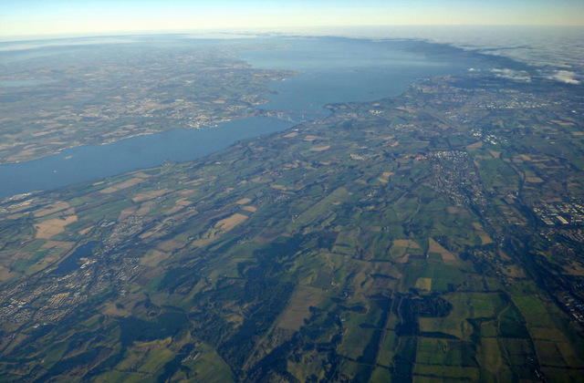
Midlothian from the air Linlithgow and Linlithgow Loch are in the left foreground, Livingston is on the right. The Forth bridges, Fife, Loch Leven, Edinburgh Airport and the city of Edinburgh can also be seen.
Midlothian from the air Credit: Thomas Nugent

Bailie's Craig Plantation is a picturesque woodland located in West Lothian, Scotland. Spanning over a vast area, this plantation is known for its tranquil beauty, rich biodiversity, and historical significance.

The woodland is predominantly composed of various species of trees, including oak, beech, birch, and Scots pine. These trees form a dense canopy, creating a serene and shaded environment. The forest floor is covered in a lush carpet of moss, ferns, and wildflowers, which adds to the natural charm of the plantation.

Bailie's Craig Plantation holds great historical importance as it was once a part of an estate owned by the Bailie family, hence the name. The remnants of an old estate house can still be found within the woodland, serving as a reminder of its past. Exploring the plantation allows visitors to immerse themselves in the area's rich heritage.

The woodland is a haven for wildlife enthusiasts and nature lovers. It is home to a diverse range of animal species, including deer, foxes, badgers, and numerous bird species. Walking trails wind through the plantation, providing visitors with the opportunity to spot these creatures in their natural habitat.

Bailie's Craig Plantation is a popular destination for outdoor activities such as hiking, birdwatching, and photography. Its natural beauty and peaceful atmosphere make it an ideal escape from the hustle and bustle of daily life. Whether one is seeking solitude or an adventure in nature, this woodland offers a memorable experience for all.

If you have any feedback on the listing, please let us know in the comments section below.

Bailie's Craig Plantation Images

Images are sourced within 2km of 55.936754/-3.5893682 or Grid Reference NT0072. Thanks to Geograph Open Source API. All images are credited.

Midlothian from the air Linlithgow and Linlithgow Loch are in the left foreground, Livingston is on the right. The Forth bridges, Fife, Loch Leven, Edinburgh Airport and the city of Edinburgh can also be seen.
Midlothian from the air
Linlithgow and Linlithgow Loch are in the left foreground, Livingston is on the right. The Forth bridges, Fife, Loch Leven, Edinburgh Airport and the city of Edinburgh can also be seen.
Shelter belt shadows Looking north from near Seafield over a landscape of shelter belts and fields. The woodland at upper right is Beecraigs Country Park. Cairnpapple Hill is visible as a circle almost on the edge of the picture, at centre left <a title="https://www.geograph.org.uk/stuff/list.php?title=Cairnpapple+Hill&gridref=NS9871" href="https://www.geograph.org.uk/stuff/list.php?title=Cairnpapple+Hill&gridref=NS9871">Link</a>. For a view 5 months later see <a href="https://www.geograph.org.uk/photo/5831102">NS9971 : Shelter belts at Knock</a>.
Shelter belt shadows
Looking north from near Seafield over a landscape of shelter belts and fields. The woodland at upper right is Beecraigs Country Park. Cairnpapple Hill is visible as a circle almost on the edge of the picture, at centre left Link. For a view 5 months later see NS9971 : Shelter belts at Knock.
Shelter belts at Knock Lochcote Reservoir is beyond. For a similar view in February, 5 months earlier, see <a href="https://www.geograph.org.uk/photo/5678807">NS9971 : Shelter belt shadows</a>.
Shelter belts at Knock
Lochcote Reservoir is beyond. For a similar view in February, 5 months earlier, see NS9971 : Shelter belt shadows.
Road through Stoney Manuel Plantation Wooded section of the minor road near Craigmailing.
Road through Stoney Manuel Plantation
Wooded section of the minor road near Craigmailing.
Downhill road in West Lothian Steep downhill section of road near Wairdlaw.
Downhill road in West Lothian
Steep downhill section of road near Wairdlaw.
Witch Craig Wood Open woodland near the summit.
Witch Craig Wood
Open woodland near the summit.
Summit, Witch Craig Above an outcrop of igneous rock.
Summit, Witch Craig
Above an outcrop of igneous rock.
Pasture land at West Tartraven Sloping farmland on the edge of the Bathgate Hills.
Pasture land at West Tartraven
Sloping farmland on the edge of the Bathgate Hills.
Beef cattle with calves A variety of breeds and cross breeds
Beef cattle with calves
A variety of breeds and cross breeds
Grassy track Track in North Mine Plantation
Grassy track
Track in North Mine Plantation
Damp hollow Surrounded by trees, heather and gorse
Damp hollow
Surrounded by trees, heather and gorse
Dyke being overtaken by trees and shrubs Marked as a district boundary on old maps
Dyke being overtaken by trees and shrubs
Marked as a district boundary on old maps
Entrance to Beecraigs path network On south west corner of Beecraigs Country Park
Entrance to Beecraigs path network
On south west corner of Beecraigs Country Park
Stile on woodland path Connecting paths in Witch Craig Wood with Beecraigs
Stile on woodland path
Connecting paths in Witch Craig Wood with Beecraigs
Path alongside dyke Woods in Beecraigs on other side of dyke
Path alongside dyke
Woods in Beecraigs on other side of dyke
Gate to Cathlawhill Wood Leading to Beecraigs path network
Gate to Cathlawhill Wood
Leading to Beecraigs path network
Spot the hut Almost concealed by surrounding vegetation
Spot the hut
Almost concealed by surrounding vegetation
Refuge stone and Witch Craig Wall The Refuge Stone marking the boundary which provided sanctuary at Torphichen Preceptory in the 12th century was restored in 2017 after being vandalised
Refuge stone and Witch Craig Wall
The Refuge Stone marking the boundary which provided sanctuary at Torphichen Preceptory in the 12th century was restored in 2017 after being vandalised
Show me another place!

Bailie's Craig Plantation is located at Grid Ref: NT0072 (Lat: 55.936754, Lng: -3.5893682)

Unitary Authority: West Lothian

Police Authority: The Lothians and Scottish Borders

What 3 Words

///applied.launch.prospered. Near Linlithgow, West Lothian

Related Wikis

Beecraigs

Beecraigs is a country park in West Lothian, approximately 2 miles (3.2 km) south of the town of Linlithgow and 3 miles (4.8 km) north-east of Bathgate...

Hilderston, West Lothian

Hilderston or Hilderstone in West Lothian, Scotland, was the site of the discovery of a vein of silver in 1606 and a mining operation that attracted international...

Cairnpapple Hill

Cairnpapple Hill is a hill with a dominating position in central lowland Scotland with views from coast to coast. It was used and re-used as a major ritual...

Cockleroi

Cockleroi or Cockleroy is a prominent hill in Scotland. It is Linlithgow's local hill. On its top there are some remains of an Iron Age's hill fort....

Nearby Amenities

Located within 500m of 55.936754,-3.5893682
Power: pole
Lat/Long: 55.9385475/-3.5826768
Power: pole
Lat/Long: 55.9387415/-3.5836931
Power: pole
Lat/Long: 55.939396/-3.5841543
Power: pole
Lat/Long: 55.9400552/-3.5846468
Power: pole
Lat/Long: 55.938219/-3.5839978
Power: pole
Lat/Long: 55.9376849/-3.5843025
Power: pole
Lat/Long: 55.9376557/-3.5853876
Power: pole
Lat/Long: 55.9376054/-3.5864686
Power: pole
Lat/Long: 55.9375598/-3.5875267
Power: pole
Lat/Long: 55.9375002/-3.5889499
Power: pole
Lat/Long: 55.9374488/-3.590346
Power: pole
Lat/Long: 55.9375247/-3.5916148
Power: pole
Lat/Long: 55.9376194/-3.593036
Power: pole
Lat/Long: 55.9376849/-3.5942484
Power: pole
Lat/Long: 55.9375388/-3.5954776
Power: pole
Lat/Long: 55.9374067/-3.5967109
Power: pole
Lat/Long: 55.937111/-3.5914666
Power: pole
Lat/Long: 55.9368223/-3.5924182
Power: pole
Lat/Long: 55.9365382/-3.5933761
Power: pole
Lat/Long: 55.9362098/-3.5944446
Power: pole
Lat/Long: 55.9360543/-3.5950456
Power: pole
Lat/Long: 55.9358743/-3.5957259
The data included in this document is from www.openstreetmap.org. The data is made available under ODbL.

Have you been to Bailie's Craig Plantation?

Leave your review of Bailie's Craig Plantation below (or comments, questions and feedback).