Polkemmet Moor

Wood, Forest in West Lothian

Scotland

Polkemmet Moor

A Cotton Grass Pond This is shown as being a body of water on the maps, but should really be downgraded to a marsh. There were once three reservoirs associated with Crofthead Colliery Pit No 5 situated close to one another here. The largest one is still full of water but both the smaller ones to the West of the track that runs North to Fauldhouse Moor are in a similar largely drained state. Their original outlines are still clear though.
The coalpit, known locally as the Victoria, first appears on an 1890s OS map and shut down in 1923. In the late 1800s and early 1900s there doesn't seem to be much that wasn't mined or quarried around Fauldhouse.
A Cotton Grass Pond Credit: Ian Dodds

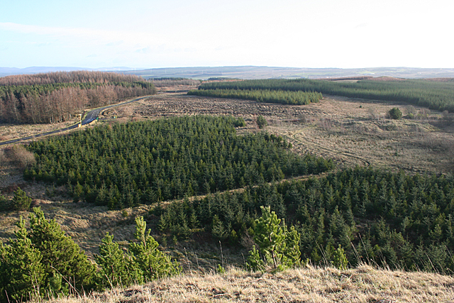
Polkemmet Moor is a picturesque woodland and moorland located in West Lothian, Scotland. Stretching across an area of approximately 500 hectares, it is a popular destination for nature enthusiasts, walkers, and families looking to escape the hustle and bustle of city life.

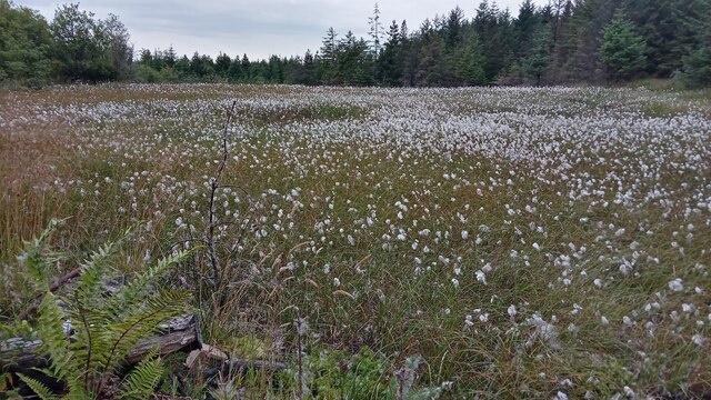
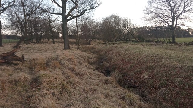
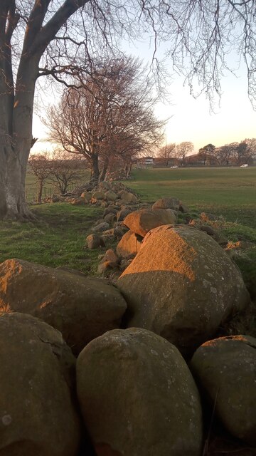
The moorland is characterized by its undulating landscape, consisting of heather-covered hills, open grasslands, and scattered patches of trees. Its unique blend of habitats makes it an important site for biodiversity, supporting a wide range of plant and animal species. Visitors can spot various bird species, including buzzards, kestrels, and skylarks, as well as mammals such as red deer, hares, and rabbits.

The woodland within Polkemmet Moor is predominantly made up of native species, including oak, birch, and rowan. The trees provide a tranquil setting, with well-maintained paths meandering through the forest, allowing visitors to explore the area at their leisure. There are also picnic areas and benches strategically placed throughout the woodland, offering visitors the chance to relax and enjoy the peaceful surroundings.

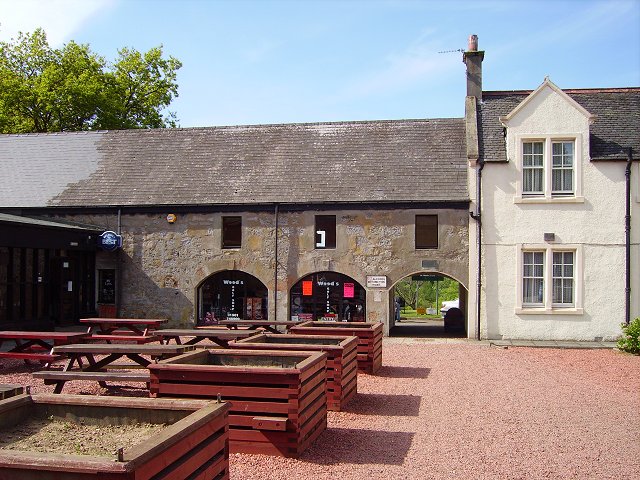
In addition to its natural beauty, Polkemmet Moor offers a range of recreational activities. There is a golf course within the moor, attracting golfers of all skill levels. The area also has a children's play area, a visitor center, and a café, providing facilities for all visitors.

Overall, Polkemmet Moor is a stunning natural landscape, offering a diverse range of habitats and recreational opportunities. Whether you are seeking a peaceful walk in the woods, a round of golf, or simply a place to connect with nature, Polkemmet Moor has something to offer everyone.

If you have any feedback on the listing, please let us know in the comments section below.

Polkemmet Moor Images

Images are sourced within 2km of 55.847265/-3.7244864 or Grid Reference NS9262. Thanks to Geograph Open Source API. All images are credited.

A Cotton Grass Pond This is shown as being a body of water on the maps, but should really be downgraded to a marsh. There were once three reservoirs associated with Crofthead Colliery Pit No 5 situated close to one another here. The largest one is still full of water but both the smaller ones to the West of the track that runs North to Fauldhouse Moor are in a similar largely drained state. Their original outlines are still clear though.
The coalpit, known locally as the Victoria, first appears on an 1890s OS map and shut down in 1923. In the late 1800s and early 1900s there doesn't seem to be much that wasn't mined or quarried around Fauldhouse.
A Cotton Grass Pond
This is shown as being a body of water on the maps, but should really be downgraded to a marsh. There were once three reservoirs associated with Crofthead Colliery Pit No 5 situated close to one another here. The largest one is still full of water but both the smaller ones to the West of the track that runs North to Fauldhouse Moor are in a similar largely drained state. Their original outlines are still clear though. The coalpit, known locally as the Victoria, first appears on an 1890s OS map and shut down in 1923. In the late 1800s and early 1900s there doesn't seem to be much that wasn't mined or quarried around Fauldhouse.
A Padlocked Padlock I have never seen this before. It looks as though the main padlock has been designed like this though, having two holes for the lower padlocks. If this is for extra security, which it surely must be, it means that the 'U' of the main padlock must have to go down further inside before releasing - otherwise it makes no sense at all, to me anyway! It looks like bolt-cutters are required to get in anyway, if you are that way inclined.
The electrical substation sits at the bottom of Colliery Lane, so named because it is part of a new housing development built on the site of the former Polkemmet mine. It is said that more man-hours were worked at this mine over its long history than any other in Scotland. 
Modern substations tend to look like this one, and a label on the side states that it weighs a nice round 500kg.
A Padlocked Padlock
I have never seen this before. It looks as though the main padlock has been designed like this though, having two holes for the lower padlocks. If this is for extra security, which it surely must be, it means that the 'U' of the main padlock must have to go down further inside before releasing - otherwise it makes no sense at all, to me anyway! It looks like bolt-cutters are required to get in anyway, if you are that way inclined. The electrical substation sits at the bottom of Colliery Lane, so named because it is part of a new housing development built on the site of the former Polkemmet mine. It is said that more man-hours were worked at this mine over its long history than any other in Scotland. Modern substations tend to look like this one, and a label on the side states that it weighs a nice round 500kg.
A Picturesque Strip This narrow and tapering strip of land runs from a fence a hundred or so yards South of this spot, until the unnamed small burn running through it reaches an early section of the River Almond about a quarter of a mile to the North at the strip's narrowest point.
The burn - which I shall christen Greenrigg Burn, as it runs close by the farm of that name South of here - is small with a decent  steady flow, and flows through the strip with the odd zig-zag here and there. The strip, shaded green on the OS map in this part, doesn't quite constitute a wood; it is more a loose collection of low trees between open gently sloping fields. Everything combines to make this a rather pretty place.
Although it looks like Greenrigg Burn rises quite close to the farm, closer inspection of the mapping shows that it starts further South, but occasionally disappears into and reappears out of marshy bits, which explains why it contains quite a bit of water.
A Picturesque Strip
This narrow and tapering strip of land runs from a fence a hundred or so yards South of this spot, until the unnamed small burn running through it reaches an early section of the River Almond about a quarter of a mile to the North at the strip's narrowest point. The burn - which I shall christen Greenrigg Burn, as it runs close by the farm of that name South of here - is small with a decent steady flow, and flows through the strip with the odd zig-zag here and there. The strip, shaded green on the OS map in this part, doesn't quite constitute a wood; it is more a loose collection of low trees between open gently sloping fields. Everything combines to make this a rather pretty place. Although it looks like Greenrigg Burn rises quite close to the farm, closer inspection of the mapping shows that it starts further South, but occasionally disappears into and reappears out of marshy bits, which explains why it contains quite a bit of water.
So Many Boulders While the grassy fields around here are unremarkable, it is worth taking a walk around them just to take in the boulders. The line at the edge of this field is probably the most substantial, but it is not an isolated case - there are lines and piles of stones and boulders at the edges of all the fields round here, and the sheer amount, and size of some of them, is pretty impressive.
Old OS maps show fields being here as far back as the 1850s, but judging by the size of some of the stones I reckon a lot of them have only recently been excavated.
So Many Boulders
While the grassy fields around here are unremarkable, it is worth taking a walk around them just to take in the boulders. The line at the edge of this field is probably the most substantial, but it is not an isolated case - there are lines and piles of stones and boulders at the edges of all the fields round here, and the sheer amount, and size of some of them, is pretty impressive. Old OS maps show fields being here as far back as the 1850s, but judging by the size of some of the stones I reckon a lot of them have only recently been excavated.
West Benhar Windfarm All seven turbines can just be made out here in the snow and drizzle, but none of them are quite yet operational - the stairs into them are all fenced off, with each turbine getting its own chequered security 'dalek'. Six of the seven currently have a number. One of them is called T8. This may be because, due to improvements in turbine efficiencies and their ever-increasing height, one less turbine than originally planned was required in order to generate the agreed amount of electricity. Or because there is an older windfarm of the same name next door whose one turbine, viewed next to these giants, looks like it should be sticking out of a sandcastle on the beach.
At their fastest the blades on these types of turbines make a full revolution about once every four seconds, and directly turn an actual turbine inside the top of the tower. A big fancy gearbox then uses lots of cogs in order to get a smaller turbine spinning round fast enough to generate the electricity.
A picture of the nearest  turbine in an early stage of construction by Jim Smillie, taken last year: <a href="https://www.geograph.org.uk/photo/7156650">NS9061 : Wind turbine base</a>
West Benhar Windfarm
All seven turbines can just be made out here in the snow and drizzle, but none of them are quite yet operational - the stairs into them are all fenced off, with each turbine getting its own chequered security 'dalek'. Six of the seven currently have a number. One of them is called T8. This may be because, due to improvements in turbine efficiencies and their ever-increasing height, one less turbine than originally planned was required in order to generate the agreed amount of electricity. Or because there is an older windfarm of the same name next door whose one turbine, viewed next to these giants, looks like it should be sticking out of a sandcastle on the beach. At their fastest the blades on these types of turbines make a full revolution about once every four seconds, and directly turn an actual turbine inside the top of the tower. A big fancy gearbox then uses lots of cogs in order to get a smaller turbine spinning round fast enough to generate the electricity. A picture of the nearest turbine in an early stage of construction by Jim Smillie, taken last year: NS9061 : Wind turbine base
Spoilheap, Polkemmet A lot of the vast area once taken over by the former coalmine here - which initially operated conventionally with underground workings, but towards the end of the 20th Century changed to opencast - has been 'remediated'. The problem with this is that the former site is now made up of unnaturally flat land with wide gravel paths and not much else going on - save for patches of emaciated grass and lonely shrubs.
It would actually be a good thing in my opinion to keep a bit of this old minescape as it is. It might not be pretty to most, but neither is the alternative, and leaving it as it is would give people an instant link to the past. (If this was 300 years old it would automatically be a scheduled monument after all.) Even this small spoilheap has a kind of majestic mini-massif appearance, it's cracks looking like (in a very idealised way!) streams and gulleys.
Spoilheap, Polkemmet
A lot of the vast area once taken over by the former coalmine here - which initially operated conventionally with underground workings, but towards the end of the 20th Century changed to opencast - has been 'remediated'. The problem with this is that the former site is now made up of unnaturally flat land with wide gravel paths and not much else going on - save for patches of emaciated grass and lonely shrubs. It would actually be a good thing in my opinion to keep a bit of this old minescape as it is. It might not be pretty to most, but neither is the alternative, and leaving it as it is would give people an instant link to the past. (If this was 300 years old it would automatically be a scheduled monument after all.) Even this small spoilheap has a kind of majestic mini-massif appearance, it's cracks looking like (in a very idealised way!) streams and gulleys.
Old mine workings on Fauldhouse Moor This area is named 'Crane Hillock' on the OS map. There is certainly a hillock but the crane has flown! Primroses were flowering in the hollows.
Old mine workings on Fauldhouse Moor
This area is named 'Crane Hillock' on the OS map. There is certainly a hillock but the crane has flown! Primroses were flowering in the hollows.
Crane Hillock on Fauldhouse Moor The hillock may be the result of the mining activity on this bleak moorland. View towards Polkemmet Moor through the Spruce forestry.
Crane Hillock on Fauldhouse Moor
The hillock may be the result of the mining activity on this bleak moorland. View towards Polkemmet Moor through the Spruce forestry.
Playground Polkemmet Country Park Two playgrounds are visible in this picture,the obvious one is for children but the building in the distance is a golf driving range for the adults.Polkemmet Country Park was the country estate of the Baillies but is now owned by West Lothian Council.
Playground Polkemmet Country Park
Two playgrounds are visible in this picture,the obvious one is for children but the building in the distance is a golf driving range for the adults.Polkemmet Country Park was the country estate of the Baillies but is now owned by West Lothian Council.
Woodland on Fauldhouse Moor This was once a golf course.
Woodland on Fauldhouse Moor
This was once a golf course.
Bing, East Benhar Mine waste near Fauldhouse. The cameras are there as a dumper deterrent.
Bing, East Benhar
Mine waste near Fauldhouse. The cameras are there as a dumper deterrent.
Harthill Road The now forested industrial landscape of Fauldhouse Moor.
Harthill Road
The now forested industrial landscape of Fauldhouse Moor.
Bing at East Benhar The bing is the spoil from the operations at Benhar Colliery, which closed down in the 1960s. It is now the highest point on Fauldhouse Moor and commands a genuinely panoramic view.
Bing at East Benhar
The bing is the spoil from the operations at Benhar Colliery, which closed down in the 1960s. It is now the highest point on Fauldhouse Moor and commands a genuinely panoramic view.
Clear Fell With the closure of the collieries, forestry is the only remaining industry on the moors between Fauldhouse and Harthill.
Clear Fell
With the closure of the collieries, forestry is the only remaining industry on the moors between Fauldhouse and Harthill.
Fauldhouse Moor A fragment of masonry betrays the site of a building among the encroaching vegetation at East Benhar.
Fauldhouse Moor
A fragment of masonry betrays the site of a building among the encroaching vegetation at East Benhar.
Ruin at East Benhar Being built of brick, this is a relic of mining days rather than of the farms which offered a hard living on the poor wet land of Fauldhouse Moor before the discovery of coal here. My thanks to John O'Connor who tells me that this was the power house.
Ruin at East Benhar
Being built of brick, this is a relic of mining days rather than of the farms which offered a hard living on the poor wet land of Fauldhouse Moor before the discovery of coal here. My thanks to John O'Connor who tells me that this was the power house.
The View from the Bing From the summit of the bing at East Benhar there is a genuinely panoramic view, of which this is part. The B718 road winds along the edge of a block of forest on the left, and you may be able to make out a CCTV camera mast beside it. What it can be monitoring up here I cannot imagine. To the right of the road is <a href="https://www.geograph.org.uk/photo/2757650">NS9161 : Clear Fell</a>, with the start of <a href="https://www.geograph.org.uk/photo/1122026">NS9161 : Upgraded forest road, Benhar</a> between it and the block of spruce. In the foreground are some of the Scots Pines which have seeded themselves on the steep slopes of the bing.
The View from the Bing
From the summit of the bing at East Benhar there is a genuinely panoramic view, of which this is part. The B718 road winds along the edge of a block of forest on the left, and you may be able to make out a CCTV camera mast beside it. What it can be monitoring up here I cannot imagine. To the right of the road is NS9161 : Clear Fell, with the start of NS9161 : Upgraded forest road, Benhar between it and the block of spruce. In the foreground are some of the Scots Pines which have seeded themselves on the steep slopes of the bing.
Ruins at East Benhar Being built of brick, these ruins are a relic of mining days rather than of the farms which offered a hard living on the poor wet land of Fauldhouse Moor before the discovery of coal here. My thanks to John O'Connor who tells me that this was originally the schoolhouse, and then a tied Forestry Commission house, and that it was still occupied in the 1960s.
Ruins at East Benhar
Being built of brick, these ruins are a relic of mining days rather than of the farms which offered a hard living on the poor wet land of Fauldhouse Moor before the discovery of coal here. My thanks to John O'Connor who tells me that this was originally the schoolhouse, and then a tied Forestry Commission house, and that it was still occupied in the 1960s.
Show me another place!

Polkemmet Moor is located at Grid Ref: NS9262 (Lat: 55.847265, Lng: -3.7244864)

Unitary Authority: West Lothian

Police Authority: The Lothians and Scottish Borders

What 3 Words

///reshaping.growth.puncture. Near Harthill, North Lanarkshire

Related Wikis

Greenrigg

Greenrigg is a small village that lies in the west of West Lothian, Scotland. Greenrigg is within walking distance to shops in the bordering village of...

Harthill Royal F.C.

Harthill Royal Football Club are a Scottish football club based in the Greenrigg area of Harthill, West Lothian. Previously an amateur side called Harthill...

Fauldhouse United F.C.

Fauldhouse United Football Club are a Scottish football club based at Park View in Fauldhouse, West Lothian. The club won the Scottish Junior Cup in 1946...

Polkemmet Country Park

Polkemmet Country Park is located 2 kilometres (1.2 mi) west of the town of Whitburn in West Lothian, Scotland and east of the village of Greenrigg. It...

Nearby Amenities

Located within 500m of 55.847265,-3.7244864
Power: pole
Lat/Long: 55.8511076/-3.7280853
Power: pole
Lat/Long: 55.8502992/-3.728264
Power: pole
Lat/Long: 55.8495097/-3.728449
Power: pole
Lat/Long: 55.8491521/-3.7280117
Power: pole
Lat/Long: 55.8485147/-3.7283418
Power: pole
Lat/Long: 55.8478632/-3.7286487
Power: pole
Lat/Long: 55.8472341/-3.7290019
Power: pole
Lat/Long: 55.8464658/-3.7297315
Power: pole
Lat/Long: 55.8457422/-3.7303979
Power: pole
Lat/Long: 55.8450116/-3.7310623
The data included in this document is from www.openstreetmap.org. The data is made available under ODbL.

Have you been to Polkemmet Moor?

Leave your review of Polkemmet Moor below (or comments, questions and feedback).