Newtonhead Wood

Wood, Forest in Lanarkshire

Scotland

Newtonhead Wood

M74 crossing the Douglas Water
M74 crossing the Douglas Water Credit: Alpin Stewart

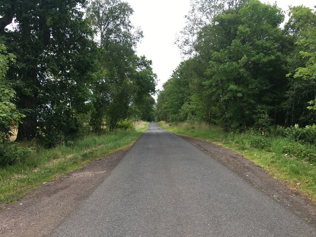
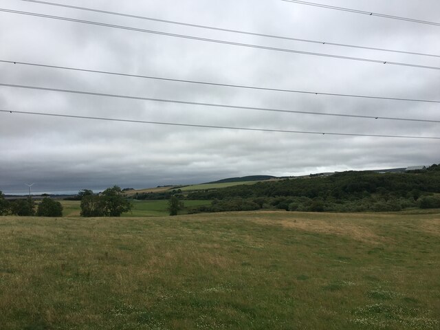
Newtonhead Wood is a picturesque woodland located in Lanarkshire, Scotland. Covering an area of approximately 30 hectares, the wood is a popular destination for nature lovers and outdoor enthusiasts. The woodland is characterized by a diverse range of tree species, including oak, beech, and birch, which provide a habitat for a variety of wildlife such as red squirrels, deer, and various bird species.

Visitors to Newtonhead Wood can enjoy a network of well-maintained walking trails that wind through the forest, offering stunning views of the surrounding countryside. The wood is also home to a number of historic features, including the ruins of an old mill and a stone bridge that dates back to the 18th century.

Newtonhead Wood is managed by the local forestry commission, who work to preserve and protect the natural beauty of the woodland for future generations to enjoy. The wood is open to the public year-round and is a peaceful retreat for those looking to escape the hustle and bustle of everyday life.

If you have any feedback on the listing, please let us know in the comments section below.

Newtonhead Wood Images

Images are sourced within 2km of 55.584921/-3.7902006 or Grid Reference NS8733. Thanks to Geograph Open Source API. All images are credited.

M74 crossing the Douglas Water
Minor road towards Douglas Water
Minor road through Happendon Wood
Farmland near Easter Tofts
Happendon Services from the air Also known as Cairn Lodge services. A service station on the M74 motorway located at junction 11 southbound and junction 12 northbound, consists of a single service area connected by road to both carriageways.
Happendon Services from the air
Also known as Cairn Lodge services. A service station on the M74 motorway located at junction 11 southbound and junction 12 northbound, consists of a single service area connected by road to both carriageways.
Field by Uddington Near a motorway junction and strewn with litter.
Field by Uddington
Near a motorway junction and strewn with litter.
A70 near Uddington
A70 near Uddington
West top, Robert Law A similar height to the one by the triangulation pillar, but possibly an ancient cairn. It's a good viewpoint.
West top, Robert Law
A similar height to the one by the triangulation pillar, but possibly an ancient cairn. It's a good viewpoint.
Rigside View from Robert Law.
Rigside
View from Robert Law.
West side of Robert Law A bit of higher ground is green and short cropped which suggests lime rich rock.
West side of Robert Law
A bit of higher ground is green and short cropped which suggests lime rich rock.
West side of Robert Law Overlooking the M74 and turbines around Douglas.
West side of Robert Law
Overlooking the M74 and turbines around Douglas.
Moorland, Robert Law Towards Limmer Hill.
Moorland, Robert Law
Towards Limmer Hill.
J12, M74 The A74(M) & M74  run over 80 miles from the M6 at the Scottish border near Gretna to the M8 at Glasgow. This is one of the two most important routeways into Scotland from the south. The last stretch of the M74 opened in 2011 (see <a title="https://www.geograph.org.uk/snippet/590" href="https://www.geograph.org.uk/snippet/590">Link</a> ).
Wikipedia: <span class="nowrap"><a title="http://en.wikipedia.org/wiki/A74(M)_and_M74_motorways" rel="nofollow ugc noopener" href="http://en.wikipedia.org/wiki/A74(M)_and_M74_motorways">Link</a><img style="margin-left:2px;" alt="External link" title="External link - shift click to open in new window" src="https://s1.geograph.org.uk/img/external.png" width="10" height="10"/></span>
J12, M74
The A74(M) & M74 run over 80 miles from the M6 at the Scottish border near Gretna to the M8 at Glasgow. This is one of the two most important routeways into Scotland from the south. The last stretch of the M74 opened in 2011 (see Link ). Wikipedia: LinkExternal link
Old milestone This milestone is by the side of a track approached through a gate on the A70.  This track between the B7078 and A70 was the route of the Carlisle to Glasgow post road.   The lost metal plate, the pegs of which remain, would have had the raised inscription
GLASGOW/arrow to left 28/CARLISLE/66½ arrow to right.   It would have been 33cm wide and 18cm high.
Old milestone
This milestone is by the side of a track approached through a gate on the A70. This track between the B7078 and A70 was the route of the Carlisle to Glasgow post road. The lost metal plate, the pegs of which remain, would have had the raised inscription GLASGOW/arrow to left 28/CARLISLE/66½ arrow to right. It would have been 33cm wide and 18cm high.
Old milestone A view of the left side of the milestone by the track.   This shows its back and rounded front plus the top of a squarish section of stone that was set into the ground.
Old milestone
A view of the left side of the milestone by the track. This shows its back and rounded front plus the top of a squarish section of stone that was set into the ground.
Old milestone A view of the back of the milestone by the track off the A70.  The main body is 99cm high, 33cm wide and 23 cm deep.   This stone has a smooth finish all over.
Old milestone
A view of the back of the milestone by the track off the A70. The main body is 99cm high, 33cm wide and 23 cm deep. This stone has a smooth finish all over.
Rigside Bustop Geocaching is a type of global treasure hunt of people looking for caches, or hidden stashes of objects. Geocaching may also be described as a series of hide-and-seek games, where hiders provide online clues for seekers. Seekers use global positioning system (GPS) devices to find hidden caches
Rigside Bustop
Geocaching is a type of global treasure hunt of people looking for caches, or hidden stashes of objects. Geocaching may also be described as a series of hide-and-seek games, where hiders provide online clues for seekers. Seekers use global positioning system (GPS) devices to find hidden caches
South Lanarkshire : The M74 Motorway Looking along the M74 motorway.
South Lanarkshire : The M74 Motorway
Looking along the M74 motorway.
Show me another place!

Newtonhead Wood is located at Grid Ref: NS8733 (Lat: 55.584921, Lng: -3.7902006)

Unitary Authority: South Lanarkshire

Police Authority: Lanarkshire

What 3 Words

///northward.tadpoles.adopts. Near Douglas, South Lanarkshire

Nearby Locations

Newtonhead Wood

Related Wikis

Rigside

Rigside is a small village in South Lanarkshire, Scotland, about 5 miles (8 kilometres) from the town of Lanark, and less than 1 mi (1.6 km) from Douglas...

South Lanarkshire

South Lanarkshire (Scots: Sooth Lanrikshire; Scottish Gaelic: Siorrachd Lannraig a Deas) is one of 32 unitary authorities of Scotland. It borders the south...

Happendon railway station

Happendon railway station served the settlement of Happendon, South Lanarkshire, Scotland, from 1864 to 1964 on the Douglas Branch. == History == The station...

Douglas Water (hamlet)

Douglas Water is a hamlet in Lanarkshire, Scotland. Named after the Douglas Water, the river which flows through the hamlet, local mining operations provided...

Related Videos

Cairn Lodge Services to Balloch (24/08/2020)

After lunch at Cairn Lodge Services I continued my journey to Oban, stopping for a walk at Balloch Castle & Country Park.

Have you been to Newtonhead Wood?

Leave your review of Newtonhead Wood below (or comments, questions and feedback).