Black-shed Wood

Wood, Forest in Perthshire

Scotland

Black-shed Wood

Tree planting at Stonehill Newly planted trees in front of established woodland near Stonehill.
Tree planting at Stonehill Credit: William Starkey

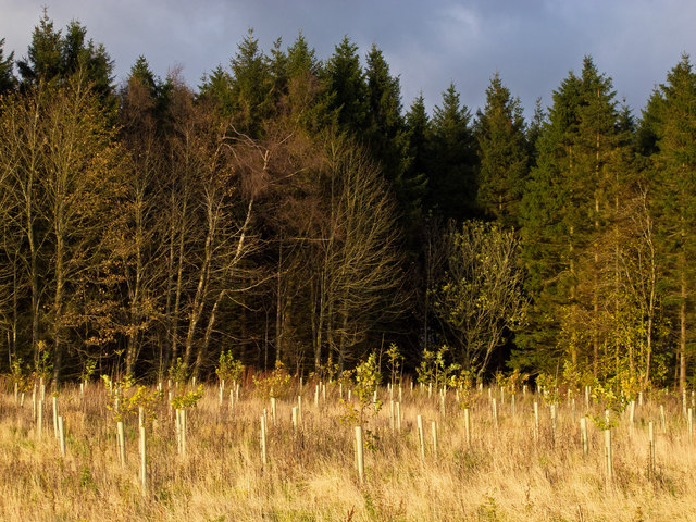
Black-shed Wood is a picturesque woodland located in Perthshire, Scotland. Covering an area of approximately 50 hectares, this enchanting forest is a haven for nature lovers and outdoor enthusiasts alike. Situated near the village of Black-shed, the woodland is easily accessible and attracts visitors from both local and international destinations.

The forest is predominantly composed of native Scottish trees such as oak, birch, and pine, which provide a rich and diverse habitat for a variety of wildlife. Visitors can expect to encounter an array of bird species, including woodpeckers, owls, and various songbirds, as well as small mammals like squirrels and hedgehogs. The tranquility of the woodland makes it an ideal spot for birdwatching and nature photography.

Black-shed Wood offers a network of well-maintained walking trails, allowing visitors to explore its natural beauty at their own pace. The paths wind through the forest, leading to hidden clearings, babbling brooks, and scenic viewpoints. The trails range in difficulty, catering to both casual strollers and more experienced hikers.

In addition to its natural attractions, Black-shed Wood also boasts a rich history. The woodland was once part of an ancient hunting estate, and remnants of old hunting lodges and stone walls can still be seen today. The area is steeped in folklore and local legends, adding an air of mystery and intrigue to the overall experience.

Whether you are seeking a peaceful escape from the hustle and bustle of everyday life or a chance to immerse yourself in Scotland's natural wonders, Black-shed Wood is a must-visit destination. With its breathtaking scenery, abundant wildlife, and rich history, this enchanting woodland offers something for everyone to enjoy.

If you have any feedback on the listing, please let us know in the comments section below.

Black-shed Wood Images

Images are sourced within 2km of 56.173425/-3.9443902 or Grid Reference NS7999. Thanks to Geograph Open Source API. All images are credited.

Tree planting at Stonehill Newly planted trees in front of established woodland near Stonehill.
Tree planting at Stonehill
Newly planted trees in front of established woodland near Stonehill.
New woodland, Stonehill More shelter for the arable land on the lower slopes of the Ochil Hills.
New woodland, Stonehill
More shelter for the arable land on the lower slopes of the Ochil Hills.
Stonehill farmland Arable land on the way up to Sheriff Muir with a view up to Meikle Corum in the Ochil Hills.

The shelter belts around Cauldhame stand out beneath the rough grazing on the hill.
Stonehill farmland
Arable land on the way up to Sheriff Muir with a view up to Meikle Corum in the Ochil Hills. The shelter belts around Cauldhame stand out beneath the rough grazing on the hill.
Farmhouse, Stonehill Now unoccupied and advertised for sale and redevelopment.
Farmhouse, Stonehill
Now unoccupied and advertised for sale and redevelopment.
Field, Dunblane Not yet built upon but one lane of the old A9 was closed and there was some Heras fencing up. Something may be happening.
Field, Dunblane
Not yet built upon but one lane of the old A9 was closed and there was some Heras fencing up. Something may be happening.
Direction Sign – Signpost on Glen Road, Dunblane Located on the east side of the crossroads of Glen Road and Sheriffmuir Road, southwest of Dunblane. 3 arms, 1 missing and ball finial. See also <a title="https://www.geograph.org.uk/photo/5431261" href="https://www.geograph.org.uk/photo/5431261">Link</a>.

Milestone Society National ID: PR_NN7900
Direction Sign – Signpost on Glen Road, Dunblane
Located on the east side of the crossroads of Glen Road and Sheriffmuir Road, southwest of Dunblane. 3 arms, 1 missing and ball finial. See also Link. Milestone Society National ID: PR_NN7900
Signpost, Dunblane A sculptural signpost incorporating various creatures including fish, frogs and dragonflies, at the junction of High Street, Beech Road and Stirling Road. The sign originally pointed to 'Cathedral Square', 'Dam Road' and 'Railway', however some of the signage is now missing on one side.
Signpost, Dunblane
A sculptural signpost incorporating various creatures including fish, frogs and dragonflies, at the junction of High Street, Beech Road and Stirling Road. The sign originally pointed to 'Cathedral Square', 'Dam Road' and 'Railway', however some of the signage is now missing on one side.
High Street, Dunblane Shops at the southern end of High Street.
High Street, Dunblane
Shops at the southern end of High Street.
Allan Water From the bridge on Stirling Road.
Allan Water
From the bridge on Stirling Road.
Old mill An old mill building beside the Allan Water. It has been on the Buildings at Risk Register <span class="nowrap"><a title="https://www.buildingsatrisk.org.uk/details/912502" rel="nofollow ugc noopener" href="https://www.buildingsatrisk.org.uk/details/912502">Link</a><img style="margin-left:2px;" alt="External link" title="External link - shift click to open in new window" src="https://s1.geograph.org.uk/img/external.png" width="10" height="10"/></span> for many years, but planning permission was conditionally approved in 2017 to convert it into a dwelling.
Old mill
An old mill building beside the Allan Water. It has been on the Buildings at Risk Register LinkExternal link for many years, but planning permission was conditionally approved in 2017 to convert it into a dwelling.
The Village Inn Late 18th century inn on Stirling Road. It is Category C listed <span class="nowrap"><a title="http://portal.historicenvironment.scot/designation/LB26420" rel="nofollow ugc noopener" href="http://portal.historicenvironment.scot/designation/LB26420">Link</a><img style="margin-left:2px;" alt="External link" title="External link - shift click to open in new window" src="https://s1.geograph.org.uk/img/external.png" width="10" height="10"/></span>.
The Village Inn
Late 18th century inn on Stirling Road. It is Category C listed LinkExternal link.
Sign for the Village Inn Inn on Stirling Road, Dunblane <a href="https://www.geograph.org.uk/photo/7162841">NN7801 : The Village Inn</a>.
Sign for the Village Inn
Inn on Stirling Road, Dunblane NN7801 : The Village Inn.
The Dunblane Public house in Stirling Road, Dunblane.
The Dunblane
Public house in Stirling Road, Dunblane.
Dunblane Post Office On Stirling Road.
Dunblane Post Office
On Stirling Road.
Dunblane Railway Station The station is Category C listed <span class="nowrap"><a title="http://portal.historicenvironment.scot/designation/LB48964" rel="nofollow ugc noopener" href="http://portal.historicenvironment.scot/designation/LB48964">Link</a><img style="margin-left:2px;" alt="External link" title="External link - shift click to open in new window" src="https://s1.geograph.org.uk/img/external.png" width="10" height="10"/></span>. It was designed by William Tite in 1848 for the Scottish Central Railway.
Dunblane Railway Station
The station is Category C listed LinkExternal link. It was designed by William Tite in 1848 for the Scottish Central Railway.
Victoria Hall Plaque on the wall of the Victoria Hall.

VICTORIA - HALL
ERECTED IN THE  - FIFTIETH YEAR OF
THE REIGN OF - H.M. QUEEN VICTORIA
JUNE - 1887
VR
Victoria Hall
Plaque on the wall of the Victoria Hall. VICTORIA - HALL ERECTED IN THE - FIFTIETH YEAR OF THE REIGN OF - H.M. QUEEN VICTORIA JUNE - 1887 VR
Victoria Hall On Stirling Road, Dunblane. Erected in 1887 <a href="https://www.geograph.org.uk/photo/7163347">NN7800 : Victoria Hall</a>. There are actually two halls and a supper room. They are used for live performances, meetings and celebrations such as civil weddings.
Victoria Hall
On Stirling Road, Dunblane. Erected in 1887 NN7800 : Victoria Hall. There are actually two halls and a supper room. They are used for live performances, meetings and celebrations such as civil weddings.
Door to Victoria Hall On Stirling Road, Dunblane.
Door to Victoria Hall
On Stirling Road, Dunblane.
Show me another place!

Black-shed Wood is located at Grid Ref: NS7999 (Lat: 56.173425, Lng: -3.9443902)

Unitary Authority: Stirling

Police Authority: Forth Valley

What 3 Words

///suffix.broke.looms. Near Dunblane, Stirling

Related Wikis

Duckburn Park

Duckburn Park was a football ground in Dunblane, Scotland. It was the home ground of Dunblane and Dunblane Rovers, and hosted a single Scottish Football...

Dunblane

Dunblane (, Scottish Gaelic: Dùn Bhlàthain) is a small town in the council area of Stirling in central Scotland, and inside the historic boundaries of...

Dunblane Hotel

Dunblane Hotel (also known as The Dunblane) is an historic building in Dunblane, Scotland. Located on Stirling Street, it is a Category C listed building...

St Mary's Episcopal Church, Dunblane

St Mary's Episcopal Church is a medium-sized church of the Scottish Episcopal Church in Dunblane, Scotland. It is situated by the Fourways roundabout....

Dunblane railway station

Dunblane railway station serves the town of Dunblane in central Scotland. It is located on the former Scottish Central Railway, between Stirling and Perth...

Diocese of Dunblane

The Diocese of Dunblane or Diocese of Strathearn was one of the thirteen historical dioceses of Scotland, before the abolition of episcopacy in the Scottish...

Bridge of Allan railway station

Bridge of Allan railway station is a railway station located in the town of Bridge of Allan, north of Stirling, Scotland. It lies between Stirling and...

Bridge of Allan

Bridge of Allan (Scots: Brig Allan, Scottish Gaelic: Drochaid Ailein), also known colloquially as Bofa, is a town in the Stirling council area in Scotland...

Nearby Amenities

Located within 500m of 56.173425,-3.9443902
Barrier: bollard
Foot: yes
Motor Vehicle: no
Lat/Long: 56.1714446/-3.9449095
The data included in this document is from www.openstreetmap.org. The data is made available under ODbL.

Have you been to Black-shed Wood?

Leave your review of Black-shed Wood below (or comments, questions and feedback).