Belt Plantation

Wood, Forest in Kirkcudbrightshire

Scotland

Belt Plantation

Building Near Spottes Burn
Building Near Spottes Burn Credit: Iain Thompson

Belt Plantation is a captivating woodland area located in the picturesque region of Kirkcudbrightshire, Scotland. Spanning across a vast expanse, the plantation is renowned for its dense forest and lush greenery.

The woodland is primarily composed of a variety of trees, including towering conifers and broadleaf species. These trees create a magnificent canopy, providing a sheltered environment for an abundance of wildlife. Visitors to Belt Plantation can expect to witness a diverse range of flora and fauna, such as red squirrels, deer, and numerous species of birds.

The plantation offers a tranquil and peaceful escape, making it a popular destination for nature enthusiasts and hikers. Several well-maintained trails wind their way through the woodland, allowing visitors to immerse themselves in the natural beauty of the area. These trails offer stunning views of the surrounding landscape, including rolling hills and distant mountains.

In addition to its natural charm, Belt Plantation also holds historical significance. The woodland has been carefully managed for centuries, with evidence of human activity dating back to medieval times. The plantation has been a source of timber and fuel for the local community, contributing to the area's rich cultural heritage.

Overall, Belt Plantation in Kirkcudbrightshire is a captivating woodland sanctuary that offers a unique blend of natural beauty and historical importance. Whether one seeks solitude in nature, a challenging hike, or an opportunity to learn about the region's past, this enchanting forest is sure to captivate visitors of all ages.

If you have any feedback on the listing, please let us know in the comments section below.

Belt Plantation Images

Images are sourced within 2km of 54.985378/-3.8953055 or Grid Reference NX7867. Thanks to Geograph Open Source API. All images are credited.

Building Near Spottes Burn
Minor Road at Three Merkland
Hermitage Farmhouse Bucolic setting just 3/4m off the busy A75.
Hermitage Farmhouse
Bucolic setting just 3/4m off the busy A75.
Across the Fields Hatton Hill across the fields.
Across the Fields
Hatton Hill across the fields.
Barn Conversion An old barn being converted to living accommodation. See <a title="https://www.geograph.org.uk/photo/263731" href="https://www.geograph.org.uk/photo/263731">Link</a>
Barn Conversion
An old barn being converted to living accommodation. See Link
Outbuildings at  Hermitage Outbuildings at Hermitage Farm near Haugh of Urr.
Outbuildings at Hermitage
Outbuildings at Hermitage Farm near Haugh of Urr.
Part of the mill complex at Old Bridge of Urr This building to the left is the Kiln House part of the original mill complex at Old Bridge of Urr. It is now being restored as a private house. Between it and the camera was a later wooden extension which has recently been demolished. The further building to the right is the Miller's House. It was later the post office and has also recently been restored. The mills themselves (a cornmill and saw mill sharing the same wheel) are out of shot to the right.
Part of the mill complex at Old Bridge of Urr
This building to the left is the Kiln House part of the original mill complex at Old Bridge of Urr. It is now being restored as a private house. Between it and the camera was a later wooden extension which has recently been demolished. The further building to the right is the Miller's House. It was later the post office and has also recently been restored. The mills themselves (a cornmill and saw mill sharing the same wheel) are out of shot to the right.
New Ramhill Bridge The new bridge was constructed to carry the main A75 Trunk Road, which runs from Stranraer to Gretna Green. An unattractive, but functional structure.
New Ramhill Bridge
The new bridge was constructed to carry the main A75 Trunk Road, which runs from Stranraer to Gretna Green. An unattractive, but functional structure.
The Old Ramhill Bridge Lying adjacent and derelict to its replacement, few if any drivers notice this old stone bridge as they speed past on the busy A75.
The Old Ramhill Bridge
Lying adjacent and derelict to its replacement, few if any drivers notice this old stone bridge as they speed past on the busy A75.
The Village of Old Bridge of Urr
Chipperkyle House
Chipperkyle House
Watching a tractor at work
River Urr Taken from the river Urr - looking up towards the Old Ramhill bridge.
River Urr
Taken from the river Urr - looking up towards the Old Ramhill bridge.
The River Urr A beautiful river - with Brown Trout and also Salmon.
The River Urr
A beautiful river - with Brown Trout and also Salmon.
Farmland and site of cairn
Burn and farmland south of Dunjarg A tranquil rural scene less than 100 metres from the busy A75
Burn and farmland south of Dunjarg
A tranquil rural scene less than 100 metres from the busy A75
Entrance to Mollance
Sheep at Mollance
Sheep at Mollance
Show me another place!

Belt Plantation is located at Grid Ref: NX7867 (Lat: 54.985378, Lng: -3.8953055)

Unitary Authority: Dumfries and Galloway

Police Authority: Dumfries and Galloway

What 3 Words

///contents.diary.sweetened. Near Castle Douglas, Dumfries & Galloway

Related Wikis

Haugh of Urr

Haugh of Urr (), is a village in the historical county of Kirkcudbrightshire in Dumfries and Galloway, Scotland. It is approximately 4 miles (6 kilometres...

Kirkpatrick Durham

Kirkpatrick Durham (Scottish Gaelic: Cill Phàdraig) is a village and parish in the historical county of Kirkcudbrightshire, Dumfries and Galloway, south...

A75 road

The A75 is a primary trunk road in Scotland, linking Stranraer and its ferry ports at Cairnryan with the A74(M) at Gretna, close to the border with England...

Springholm

Springholm is a village in the historical county of Kirkcudbrightshire in Dumfries and Galloway, Scotland. It is located 14 miles (23 km) west of Dumfries...

Kilquhanity School

Kilquhanity School was one of several free schools to have been established in the United Kingdom in the twentieth century. Others include Sands School...
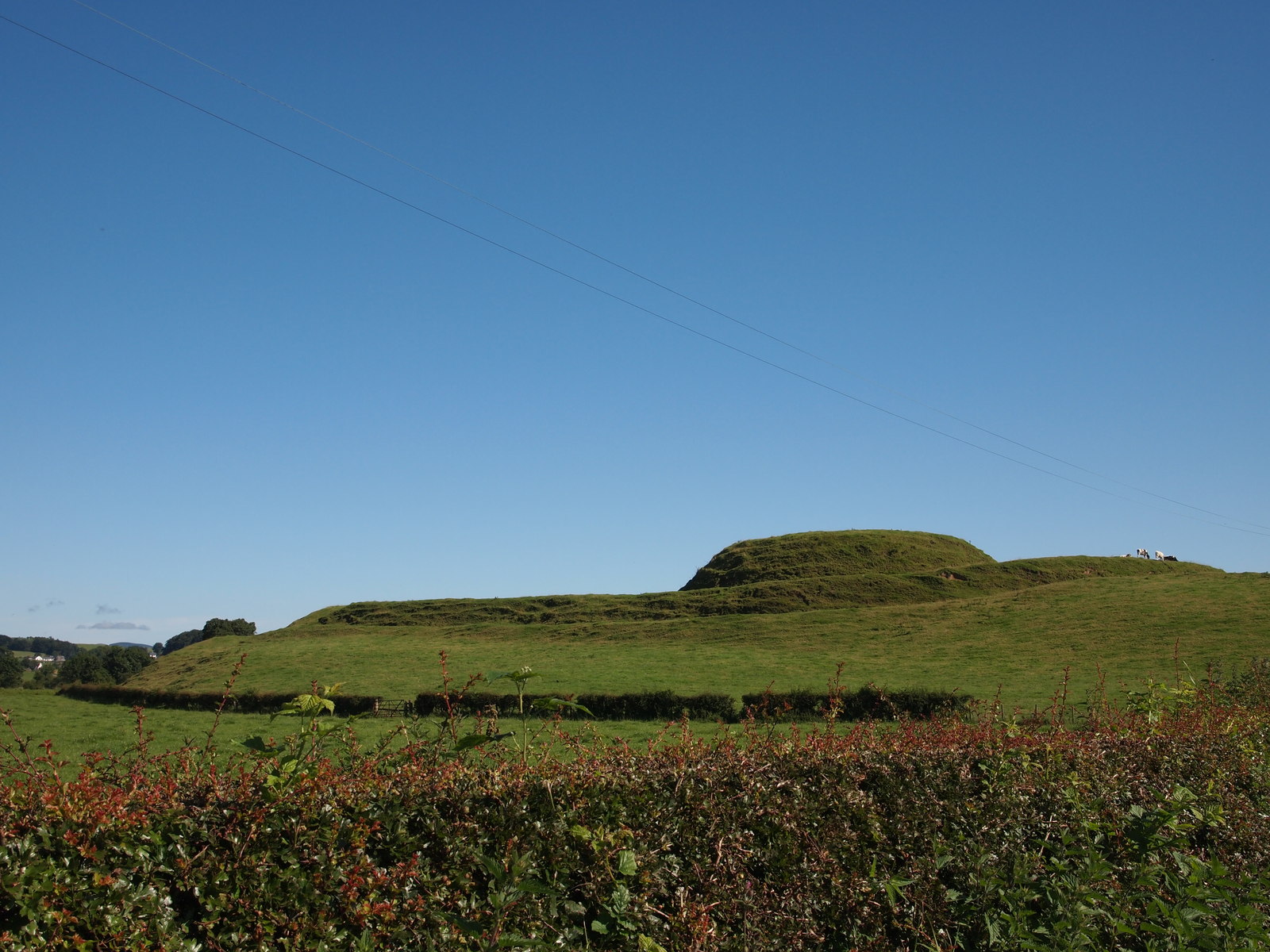
Motte of Urr

The Motte of Urr is the remains of a 12th-century motte-and-bailey castle located near the Haugh of Urr in Dumfries and Galloway, Scotland. == History... ==

Buittle railway station

Buittle railway station, also known as Buittle Halt, Buittle Mill and Buittle Mill Halt, served the civil parish of Buittle, Dumfries and Galloway, Scotland...

Castle Douglas High School

Castle Douglas High School is a comprehensive state school situated in Castle Douglas in the historical county of Kirkcudbrightshire. It has approximately...

Nearby Amenities

Located within 500m of 54.985378,-3.8953055
Generator Method: wind_turbine
Generator Source: wind
Power: generator
Lat/Long: 54.9831221/-3.8998209
Power: pole
Lat/Long: 54.9816254/-3.8942539
Power: pole
Lat/Long: 54.9824179/-3.8933947
Power: pole
Lat/Long: 54.9830083/-3.8927604
Power: pole
Lat/Long: 54.9834977/-3.8922237
Power: pole
Lat/Long: 54.9842828/-3.8913433
Power: pole
Lat/Long: 54.9832323/-3.8919903
Power: pole
Lat/Long: 54.9829219/-3.8917378
Power: pole
Lat/Long: 54.9830984/-3.8907832
Power: pole
Lat/Long: 54.9847466/-3.8899155
Power: pole
Lat/Long: 54.9851714/-3.8886257
Power: pole
Lat/Long: 54.9828793/-3.9012483
Power: pole
Lat/Long: 54.9834794/-3.8999966
Power: pole
Lat/Long: 54.9832506/-3.8993411
Power: pole
Lat/Long: 54.9829779/-3.8985774
Power: pole
Lat/Long: 54.9827052/-3.897784
Power: pole
Lat/Long: 54.9831824/-3.897103
Power: pole
Lat/Long: 54.9831933/-3.896335
Power: pole
Lat/Long: 54.9831897/-3.896021
The data included in this document is from www.openstreetmap.org. The data is made available under ODbL.

Have you been to Belt Plantation?

Leave your review of Belt Plantation below (or comments, questions and feedback).