Glen Wood

Wood, Forest in Lanarkshire

Scotland

Glen Wood

Cathkin Braes Trig Point Flush Bracket S3662
Cathkin Braes Trig Point Flush Bracket S3662 Credit: thejackrustles

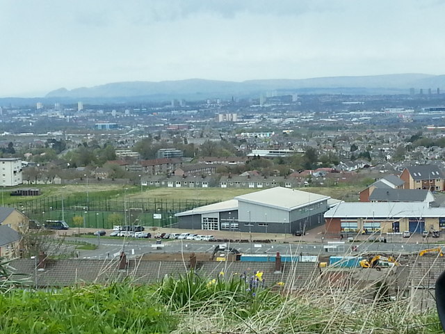
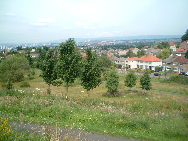
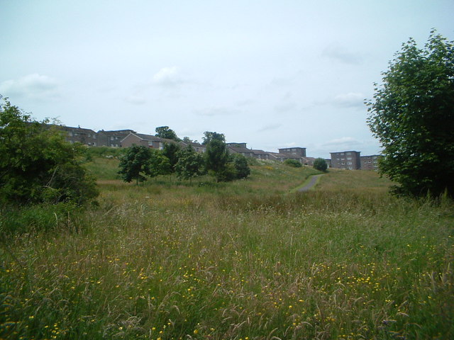
Glen Wood, located in Lanarkshire, Scotland, is an enchanting forest area that offers a serene escape from the hustle and bustle of city life. Covering an expansive area, Glen Wood is characterized by its lush greenery, towering trees, and diverse wildlife.

This woodland gem is a haven for nature lovers and outdoor enthusiasts, providing various recreational activities. Hiking trails crisscross the forest, leading visitors through picturesque landscapes and offering breathtaking views of the surrounding hills. The trails cater to all levels of fitness, from leisurely strolls to more challenging treks, ensuring there is something for everyone.

Glen Wood is home to a rich variety of flora and fauna. The forest is dominated by majestic oak, beech, and pine trees, creating a dense canopy that filters sunlight and creates a cool and tranquil atmosphere. Wildflowers, such as bluebells and primroses, carpet the forest floor during spring, adding vibrant colors to the surroundings. The woodland is teeming with wildlife, including deer, squirrels, foxes, and a wide array of bird species, making it a paradise for birdwatchers and wildlife enthusiasts.

For those seeking solitude and relaxation, Glen Wood offers peaceful picnic spots and quiet corners where one can unwind and soak in the natural beauty. Visitors can also enjoy camping facilities or partake in organized events and educational programs, which provide insights into the forest's history, ecology, and conservation efforts.

Overall, Glen Wood is a tranquil oasis nestled in the heart of Lanarkshire, offering a perfect blend of natural beauty, recreational activities, and a chance to reconnect with nature.

If you have any feedback on the listing, please let us know in the comments section below.

Glen Wood Images

Images are sourced within 2km of 55.804524/-4.2247313 or Grid Reference NS6059. Thanks to Geograph Open Source API. All images are credited.

Cathkin Braes Trig Point Flush Bracket S3662
Carmunnock Looking towards the junction where the road over the Cathkin Braes arrives at the village.
Carmunnock
Looking towards the junction where the road over the Cathkin Braes arrives at the village.
Footbridge in Cathkin Braes Park The footbridge is on the path into the park from Ardencraig Road. The Big Wood is behind. The bridge is seen from the other side in <a href="https://www.geograph.org.uk/photo/3241672">NS6058 : Footbridge in Cathkin Braes Country Park</a>.
Footbridge in Cathkin Braes Park
The footbridge is on the path into the park from Ardencraig Road. The Big Wood is behind. The bridge is seen from the other side in NS6058 : Footbridge in Cathkin Braes Country Park.
Castlemilk and Cathkin Braes Park The path at the bottom leads walkers from Ardencraig Road through a little bit of wood to the open part of the Cathkin Braes. Behind is the south edge of Catlemilk, with more of Glasgow and the Campsies beyond.
Castlemilk and Cathkin Braes Park
The path at the bottom leads walkers from Ardencraig Road through a little bit of wood to the open part of the Cathkin Braes. Behind is the south edge of Catlemilk, with more of Glasgow and the Campsies beyond.
Fernhill Community Centre View over Fernhill Community Centre and surroundings from the south of the estate
Fernhill Community Centre
View over Fernhill Community Centre and surroundings from the south of the estate
New Playpark, Fernhill
Fernhill 2005 View over Fernhill in 2005 prior to the refurbishment of much of the area's buildings
Fernhill 2005
View over Fernhill in 2005 prior to the refurbishment of much of the area's buildings
Boy Wonder View of Kenny Hunter statue known as King of the Castle  and Boy Wonder
Boy Wonder
View of Kenny Hunter statue known as King of the Castle and Boy Wonder
Fernhill welcome wall An old style sandstone wall section, but a 21st century addition, denoting the eastern entrance to the Fernhill housing estate
Fernhill welcome wall
An old style sandstone wall section, but a 21st century addition, denoting the eastern entrance to the Fernhill housing estate
Colvend Drive 2005 View of the Colvend Drive area of Fernhill in 2005, prior to the redevelopment of the housing
Colvend Drive 2005
View of the Colvend Drive area of Fernhill in 2005, prior to the redevelopment of the housing
Fernhill gardens Attractive domestic gardens in Fernhill 2005
Fernhill gardens
Attractive domestic gardens in Fernhill 2005
Towards Neilvaig Drive View South over refurbished blocks in Neilvaig Drive, with High Burnside beyond and Clydebridge steel works in the distance
Towards Neilvaig Drive
View South over refurbished blocks in Neilvaig Drive, with High Burnside beyond and Clydebridge steel works in the distance
Gap site at Fernhill shops The site of the row of shops in Fernhill is cleared awaiting redevelopment, 2014
Gap site at Fernhill shops
The site of the row of shops in Fernhill is cleared awaiting redevelopment, 2014
To Burnside from Fernhill Park Looking northwest from the footpath in the informal parkland area between Fernhill and High Burnside. Celtic Park can be seen in the distance
To Burnside from Fernhill Park
Looking northwest from the footpath in the informal parkland area between Fernhill and High Burnside. Celtic Park can be seen in the distance
Fernhill from footpath Looking southwest towards lower Fernhill from the parkland footpath
Fernhill from footpath
Looking southwest towards lower Fernhill from the parkland footpath
Castlefern Road Castlefern Road in Fernhill, 2015
Castlefern Road
Castlefern Road in Fernhill, 2015
Felines of Fernhill Decorative murals featuring cats now adorn this enclosed parking area
Felines of Fernhill
Decorative murals featuring cats now adorn this enclosed parking area
Preparing for an excursion to Cathkin Braes Members of Glasgow Natural History Society prepare to visit Cathkin Braes on a wet afternoon, as they recreate the first excursion of the Andersonian Naturalists’ Society in August 1885. The society's object was 'to encourage the study of natural science in all its branches', which it continued to do until 1930. It then amalgamated with the Natural History Society of Glasgow and the Microscopical Society of Glasgow to form the Glasgow and Andersonian Natural History and Microscopical Society. It changed its name in 1979 to become the Glasgow Natural History Society.
Preparing for an excursion to Cathkin Braes
Members of Glasgow Natural History Society prepare to visit Cathkin Braes on a wet afternoon, as they recreate the first excursion of the Andersonian Naturalists’ Society in August 1885. The society's object was 'to encourage the study of natural science in all its branches', which it continued to do until 1930. It then amalgamated with the Natural History Society of Glasgow and the Microscopical Society of Glasgow to form the Glasgow and Andersonian Natural History and Microscopical Society. It changed its name in 1979 to become the Glasgow Natural History Society.
Show me another place!

Glen Wood is located at Grid Ref: NS6059 (Lat: 55.804524, Lng: -4.2247313)

Unitary Authority: City of Glasgow

Police Authority: Greater Glasgow

What 3 Words

///assure.mixer.same. Near Carmunnock, Glasgow

Nearby Locations

Castlemilk Glen Wood

Related Wikis

Bogany Flats

Bogany Flats was a multi-storey block of flats in Castlemilk, Glasgow. The flats were built in 1966 by George Wimpey Ltd, the last of the nine tower blocks...

Castlemilk High School

Castlemilk High School is a co-educational comprehensive secondary school located in Castlemilk, Glasgow, Scotland. It was established in 1990 from a merger...
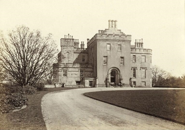
Castlemilk House

Castlemilk House was a country house located in what is now the Castlemilk district of Glasgow, Scotland. The house was the ancestral home of the Stirling...

Castlemilk

Castlemilk (Scottish Gaelic: Caisteal Mheilc) is a district of Glasgow, Scotland. It lies to the far south of the city centre, adjacent to the Croftfoot...

Nearby Amenities

Located within 500m of 55.804524,-4.2247313
Traffic Signals
Lat/Long: 55.8054244/-4.2315338
Castlemilk
Name Gd: Caisteal Meilc
Name Sco: The Milk
Place: suburb
Wikidata: Q5050553
Wikipedia: en:Castlemilk
Lat/Long: 55.8052706/-4.230395
Bus Stop
Castlemilk, Ardencraig Road/ Ardencraig Drive
Naptan AtcoCode: 60902384
Naptan Bearing: E
Naptan CommonName: St Martins Church
Naptan Indicator: Opp
Naptan Landmark: Ardencraig Drive
Naptan NaptanCode: 45234575
Naptan Street: Ardencraig Road
Ref: 60902384
Lat/Long: 55.80212/-4.21881
Bus Stop
Castlemilk, Ardencraig Road/ Ardencraig Street
Naptan AtcoCode: 60902390
Naptan Bearing: W
Naptan CommonName: Ardencraig Street
Naptan Indicator: after
Naptan Landmark: Ardencraig Street
Naptan NaptanCode: 45236837
Naptan Street: Ardencraig Road
Ref: 60902390
Lat/Long: 55.80472/-4.21853
Bus Stop
Castlemilk, Ardencraig Road/ Ardencraig Terrace
Naptan AtcoCode: 60903484
Naptan Bearing: W
Naptan CommonName: Ardencraig Terrace
Naptan Indicator: At
Naptan Landmark: Ardencraig Terrace
Naptan NaptanCode: 45235824
Naptan Street: Ardencraig Road
Ref: 60903484
Lat/Long: 55.80397/-4.22694
Bus Stop
Castlemilk, Ardencraig Road/ Ardencraig Terrace
Naptan AtcoCode: 60902394
Naptan Bearing: E
Naptan CommonName: Ardencraig Terrace
Naptan Indicator: Opp
Naptan Landmark: Ardencraig Terrace
Naptan NaptanCode: 45232387
Naptan Street: Ardencraig Road
Ref: 60902394
Lat/Long: 55.8041/-4.22634
Bus Stop
Castlemilk, Ardencraig Road/ Ardencraig Terrace
Naptan AtcoCode: 60902393
Naptan Bearing: W
Naptan CommonName: Miller Primary School
Naptan Indicator: at
Naptan Landmark: Ardencraig Terrace
Naptan NaptanCode: 45238425
Naptan Street: Ardencraig Road
Ref: 60902393
Lat/Long: 55.80419/-4.22322
Bus Stop
Castlemilk, Ardencraig Road/ Crichton Court
Naptan AtcoCode: 60902379
Naptan Bearing: SW
Naptan CommonName: Mitchell Hill Road
Naptan Indicator: after
Naptan Landmark: Crichton Court
Naptan NaptanCode: 45236897
Naptan Street: Ardencraig Road
Ref: 60902379
Lat/Long: 55.80073/-4.22562
Bus Stop
Castlemilk, Ardencraig Road/ Hoddam Avenue
Naptan AtcoCode: 60902392
Naptan Bearing: E
Naptan CommonName: Miller Primary School
Naptan Indicator: opp
Naptan Landmark: Hoddam Avenue
Naptan NaptanCode: 45242586
Naptan Street: Ardencraig Road
Ref: 60902392
Lat/Long: 55.8043307/-4.2227186
Bus Stop
Castlemilk, Ardencraig Road/ Hoddam Avenue
Naptan AtcoCode: 60902391
Naptan Bearing: E
Naptan CommonName: Hoddam Avenue
Naptan Indicator: before
Naptan Landmark: Hoddam Avenue
Naptan NaptanCode: 45232846
Naptan Street: Ardencraig Road
Ref: 60902391
Lat/Long: 55.80473/-4.21936
Bus Stop
Castlemilk, Ardencraig Road/ Mitchell Hill Road
Naptan AtcoCode: 60902380
Naptan Bearing: NE
Naptan CommonName: Mitchell Hill Road
Naptan Indicator: opp
Naptan Landmark: Mitchell Hill Road
Naptan NaptanCode: 45232894
Naptan Street: Ardencraig Road
Ref: 60902380
Lat/Long: 55.80091/-4.22554
Bus Stop
Castlemilk, Ardencraig Road/ Mitchell Hill Road
Naptan AtcoCode: 60902381
Naptan Bearing: SW
Naptan CommonName: Mitchell Hill Road
Naptan Indicator: before
Naptan Landmark: Mitchell Hill Road
Naptan NaptanCode: 45235654
Naptan Street: Ardencraig Road
Ref: 60902381
Lat/Long: 55.80165/-4.22268
Bus Stop
Castlemilk, Ardencraig Road/ Mitchell Hill Road
Naptan AtcoCode: 60902382
Naptan Bearing: NE
Naptan CommonName: Mitchell Hill Road
Naptan Indicator: Opp
Naptan Landmark: Mitchell Hill Road
Naptan NaptanCode: 45236983
Naptan Street: Ardencraig Road
Ref: 60902382
Lat/Long: 55.80183/-4.2224
Bus Stop
Castlemilk, Ardencraig Road/ Mitchell Hill Road
Naptan AtcoCode: 60902383
Naptan Bearing: W
Naptan CommonName: St Martins Church
Naptan Indicator: At
Naptan Landmark: Mitchell Hill Road
Naptan NaptanCode: 45243568
Naptan Street: Ardencraig Road
Ref: 60902383
Lat/Long: 55.80198/-4.21931
Bus Stop
Castlemilk, Castlemilk Drive/ Dougrie Road
Naptan AtcoCode: 60902433
Naptan Bearing: NW
Naptan CommonName: Glenwood Place
Naptan Indicator: before
Naptan Landmark: Dougrie Road
Naptan NaptanCode: 45236292
Naptan Street: Castlemilk Drive
Ref: 60902433
Lat/Long: 55.80445/-4.23013
Bus Stop
Castlemilk, Castlemilk Drive/ Dougrie Road
Naptan AtcoCode: 60902432
Naptan Bearing: SE
Naptan CommonName: Shopping Centre
Naptan Indicator: opp
Naptan Landmark: Dougrie Road
Naptan NaptanCode: 45242396
Naptan Street: Castlemilk Drive
Ref: 60902432
Lat/Long: 55.80584/-4.23209
Bus Stop
Castlemilk, Castlemilk Drive/ Glenwood Place
Naptan AtcoCode: 60902434
Naptan Bearing: S
Naptan CommonName: Ardencraig Road
Naptan Indicator: before
Naptan Landmark: Glenwood Place
Naptan NaptanCode: 45242894
Naptan Street: Castlemilk Drive
Ref: 60902434
Lat/Long: 55.80418/-4.22964
Bus Stop
Castlemilk, Castlemilk Drive/ Lenihall Drive
Naptan AtcoCode: 60902435
Naptan Bearing: NE
Naptan CommonName: Lenihall Drive
Naptan Indicator: before
Naptan Landmark: Lenihall Drive
Naptan NaptanCode: 45236972
Naptan Street: Castlemilk Drive
Ref: 60902435
Lat/Long: 55.80321/-4.23
Bus Stop
Castlemilk, Dougrie Road/ Castlemilk Drive
Naptan AtcoCode: 60902456
Naptan Bearing: NE
Naptan CommonName: Sports Centre
Naptan Indicator: At
Naptan Landmark: Castlemilk Drive
Naptan NaptanCode: 45237847
Naptan Street: Dougrie Road
Ref: 60902456
Lat/Long: 55.80518/-4.23218
Bus Stop
Castlemilk, Dougrie Road/ Dougrie Place
Naptan AtcoCode: 60902455
Naptan Bearing: SW
Naptan CommonName: Sports Centre
Naptan Indicator: Opp
Naptan Landmark: Dougrie Place
Naptan NaptanCode: 45238727
Naptan Street: Dougrie Road
Ref: 60902455
Lat/Long: 55.80513/-4.2321
Bicycle Parking
Bicycle Parking: stands
Capacity: 4
Covered: no
Lat/Long: 55.8052532/-4.2309492
Noexit: yes
Lat/Long: 55.8030222/-4.2313631
The data included in this document is from www.openstreetmap.org. The data is made available under ODbL.

Have you been to Glen Wood?

Leave your review of Glen Wood below (or comments, questions and feedback).