Altnaharra Wood

Wood, Forest in Sutherland

Scotland

Altnaharra Wood

Strath Vagastie The trees are now well established in the enclosure by the river.
Strath Vagastie Credit: Richard Webb

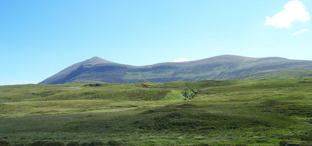
Altnaharra Wood is a captivating forest located in the heart of Sutherland, Scotland. This woodland is nestled amidst the stunning landscape of the Scottish Highlands, showcasing the region's natural beauty. With an extensive area of approximately 100 hectares, Altnaharra Wood is a haven for nature enthusiasts and outdoor adventurers.

The wood is characterized by its diverse range of tree species, including native Scots pine, birch, and rowan. These towering trees create a dense canopy, offering shade and shelter to a plethora of flora and fauna. The forest floor is carpeted with a rich variety of wildflowers, ferns, and mosses, creating a vivid tapestry of colors and textures.

Altnaharra Wood is renowned for its wildlife, attracting a wide array of species. Nature lovers may spot red deer, roe deer, and even the elusive pine marten roaming through the forest. The wood is also home to a variety of bird species, such as golden eagles, ospreys, and red kites, making it a paradise for birdwatching enthusiasts.

The forest is crisscrossed by a network of walking trails, allowing visitors to immerse themselves in the tranquility of nature. These paths wind through the wood, offering breathtaking views of the surrounding mountains and lochs. Exploring Altnaharra Wood provides an opportunity to connect with nature, breathe in the fresh Highland air, and enjoy the serenity of the Scottish countryside.

Overall, Altnaharra Wood is a captivating destination that showcases the natural wonders of the Scottish Highlands. Its diverse flora and fauna, stunning landscapes, and peaceful ambiance make it a must-visit location for those seeking an authentic wilderness experience.

If you have any feedback on the listing, please let us know in the comments section below.

Altnaharra Wood Images

Images are sourced within 2km of 58.278425/-4.4411304 or Grid Reference NC5634. Thanks to Geograph Open Source API. All images are credited.

Strath Vagastie The trees are now well established in the enclosure by the river.
Strath Vagastie
The trees are now well established in the enclosure by the river.
A836, Strath Vagastie
Road (A836) passing between felled and mature woodland as it descends towards Altnaharra Looking south-westward.
Road (A836) passing between felled and mature woodland as it descends towards Altnaharra
Looking south-westward.
Minor moorland road near to Cnoc Dubh Looking south-eastward in the direction of Altnaharra.
Minor moorland road near to Cnoc Dubh
Looking south-eastward in the direction of Altnaharra.
The minor road from Hope joining the A836 and B873 roads near to Altnaharra Looking south-eastward.
The minor road from Hope joining the A836 and B873 roads near to Altnaharra
Looking south-eastward.
Road (B873) leaving Altnaharra Looking eastward towards Loch Naver.
Road (B873) leaving Altnaharra
Looking eastward towards Loch Naver.
Strath Vagastie - Road (A836) near to Druim Allt na h-Aire Looking north-eastward.
Strath Vagastie - Road (A836) near to Druim Allt na h-Aire
Looking north-eastward.
Strath Vagastie - Road (A836) approaching Altnaharra Looking north-eastward.
Strath Vagastie - Road (A836) approaching Altnaharra
Looking north-eastward.
Strath Vagastie - Road (A836) approaching Altnaharra Looking north-eastward.
Strath Vagastie - Road (A836) approaching Altnaharra
Looking north-eastward.
Road (B873) near to Loch Naver Looking eastward.
Road (B873) near to Loch Naver
Looking eastward.
Infilling lochan on moorland The lochan is on moorland on the south side of a minor road, north-west of Altnaharra. The River Mudale flows not far beyond the lochan and Ben Klibreck is the distant, snowed mountain.
Infilling lochan on moorland
The lochan is on moorland on the south side of a minor road, north-west of Altnaharra. The River Mudale flows not far beyond the lochan and Ben Klibreck is the distant, snowed mountain.
Ordnance Survey Flush Bracket G2060 This bracket can be found on the wall of Invermudale Lodge - a private dwelling - in Altnaharra.
The recorded details give a height of 82.2552 metres above sea level.
For more details see : <span class="nowrap"><a title="https://www.bench-marks.org.uk/bm18257" rel="nofollow ugc noopener" href="https://www.bench-marks.org.uk/bm18257">Link</a><img style="margin-left:2px;" alt="External link" title="External link - shift click to open in new window" src="https://s1.geograph.org.uk/img/external.png" width="10" height="10"/></span>
Ordnance Survey Flush Bracket G2060
This bracket can be found on the wall of Invermudale Lodge - a private dwelling - in Altnaharra. The recorded details give a height of 82.2552 metres above sea level. For more details see : LinkExternal link
Blooming heather at Altnaharra A forestry corner to the north of the hamlet.
Blooming heather at Altnaharra
A forestry corner to the north of the hamlet.
Field, Strath Vagastie A silage crop had just been cut. The field is surrounded by a fast growing native woodland. A building <a href="https://www.geograph.org.uk/photo/1953215">NC5633 : Shed in Strath Vagastie</a> that used to be a prominent landmark on the A836, is now almost completely hidden.
Field, Strath Vagastie
A silage crop had just been cut. The field is surrounded by a fast growing native woodland. A building NC5633 : Shed in Strath Vagastie that used to be a prominent landmark on the A836, is now almost completely hidden.
River Vagastie In recent years a birch wood has become established here.
River Vagastie
In recent years a birch wood has become established here.
Young woodland, Altnaharra Recently planted native trees in Strath Vagastie.
Young woodland, Altnaharra
Recently planted native trees in Strath Vagastie.
A836, Strath Vagastie Approaching Altnaharra.
A836, Strath Vagastie
Approaching Altnaharra.
Native woodland plantation, Altnaharra Young trees in Strath Vagastie.
Native woodland plantation, Altnaharra
Young trees in Strath Vagastie.
Show me another place!

Altnaharra Wood is located at Grid Ref: NC5634 (Lat: 58.278425, Lng: -4.4411304)

Unitary Authority: Highland

Police Authority: Highlands and Islands

What 3 Words

///unframed.tapers.afterglow. Near Altnaharra, Highland

Related Wikis

Altnaharra

Altnaharra (Scottish Gaelic: Allt na h-Eirbhe) is a small hamlet in Sutherland in the Highland region of northern Scotland. The hamlet is on the A836...

Sutherland

Sutherland (Scottish Gaelic: Cataibh) is a historic county, registration county and lieutenancy area in the Highlands of Scotland. Its county town is Dornoch...

Ben Klibreck

Ben Klibreck (Scottish Gaelic: Beinn Clìbric) is a Scottish mountain located in central Sutherland. It is an isolated mountain, rising above a large area...

Loch Naver

Loch Naver is a loch in the Farr parish in Sutherland in the Highland council area of northern Scotland. It is situated upon the B873 main road. Upon the...

Loch Choire

Loch Choire is a loch in Sutherland in the Highland council area of northern Scotland. It is located at the end of a rural street which links the loch...

Nearby Amenities

Located within 500m of 58.278425,-4.4411304
Altnaharra
Name Gd: Allt na h-Eirbhe
Old Name: Altnaharrow
Place: village
Source Old Name: OS-6in
Wikidata: Q443014
Wikipedia: en:Altnaharra
Lat/Long: 58.2822128/-4.4412206
Pub
Ghillies Bar
Lat/Long: 58.2814429/-4.4425394
Power: pole
Lat/Long: 58.2819437/-4.4443228
Power: pole
Lat/Long: 58.2817421/-4.4438653
Power: pole
Lat/Long: 58.2819407/-4.4433942
Power: pole
Lat/Long: 58.2822324/-4.4423624
Power: pole
Lat/Long: 58.2816459/-4.4404838
Power: pole
Lat/Long: 58.2814985/-4.4393372
Power: pole
Lat/Long: 58.2812657/-4.4374858
Power: pole
Lat/Long: 58.2807324/-4.4368775
Power: pole
Lat/Long: 58.2802074/-4.4362876
Power: pole
Lat/Long: 58.2795508/-4.4355342
Power: pole
Lat/Long: 58.2762855/-4.4342582
Power: pole
Lat/Long: 58.2763009/-4.4346242
Power: pole
Lat/Long: 58.2763531/-4.4350291
Power: pole
Lat/Long: 58.2761504/-4.4344275
Power: pole
Lat/Long: 58.2759303/-4.4346942
Power: pole
Lat/Long: 58.2753509/-4.4354243
Power: pole
Lat/Long: 58.2748811/-4.4360063
Power: pole
Lat/Long: 58.2763567/-4.4356209
Power: pole
Lat/Long: 58.2773219/-4.4364901
Power: pole
Lat/Long: 58.2786132/-4.436823
Power: pole
Lat/Long: 58.2788967/-4.4364259
Power: pole
Lat/Long: 58.2791966/-4.4359976
Power: pole
Lat/Long: 58.2802406/-4.4346096
Power: pole
Lat/Long: 58.2804336/-4.4342465
The data included in this document is from www.openstreetmap.org. The data is made available under ODbL.

Have you been to Altnaharra Wood?

Leave your review of Altnaharra Wood below (or comments, questions and feedback).