Gartrenich Moss

Wood, Forest in Perthshire

Scotland

Gartrenich Moss

River Forth from the bridge near Gartrenich A view of the Forth looking downstream.
River Forth from the bridge near Gartrenich Credit: James T M Towill

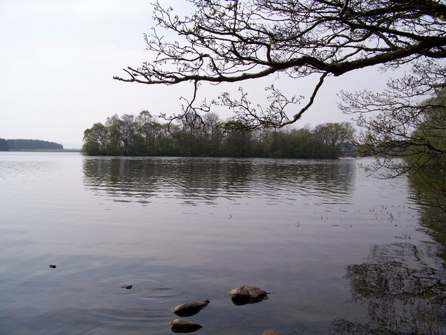
Gartrenich Moss is a stunning wood and forest located in Perthshire, Scotland. Covering an extensive area of approximately 200 hectares, it is a haven for nature enthusiasts and hikers alike. The moss is situated near the village of Comrie, nestled within the picturesque Scottish countryside.

The woodlands in Gartrenich Moss are predominantly made up of native species, including oak, birch, and pine trees. These trees create a lush and diverse habitat, providing shelter and sustenance for a wide variety of wildlife. Visitors can expect to encounter an array of bird species, such as woodpeckers, owls, and red kites soaring above.

The forest floor of Gartrenich Moss is adorned with a rich carpet of mosses, ferns, and wildflowers, adding to the enchanting atmosphere of the area. As one ventures deeper into the wood, they may stumble upon charming streams and small cascades, enhancing the natural beauty of the surroundings.

Gartrenich Moss offers numerous walking trails and paths, catering to all levels of fitness and experience. These trails allow visitors to explore the woodlands at their own pace, immersing themselves in the tranquility and serenity of the area. The moss is also home to various recreational activities such as wildlife photography, nature observation, and picnicking.

With its breathtaking landscapes and abundant flora and fauna, Gartrenich Moss is a must-visit destination for nature lovers seeking a true Scottish woodland experience. Its accessibility and proximity to nearby villages make it an ideal location to escape the hustle and bustle of daily life and reconnect with nature.

If you have any feedback on the listing, please let us know in the comments section below.

Gartrenich Moss Images

Images are sourced within 2km of 56.148854/-4.3222942 or Grid Reference NS5597. Thanks to Geograph Open Source API. All images are credited.

River Forth from the bridge near Gartrenich A view of the Forth looking downstream.
River Forth from the bridge near Gartrenich
A view of the Forth looking downstream.
Auchentroig Burn A railway line was completed in 1882 across Flanders Moss between Buchlyvie and Aberfoyle. It closed in the late 1950's and is now a forestry road, here crossing a small tributary of the River Forth.
Auchentroig Burn
A railway line was completed in 1882 across Flanders Moss between Buchlyvie and Aberfoyle. It closed in the late 1950's and is now a forestry road, here crossing a small tributary of the River Forth.
Bridge over Kelty Water at Barbadoes Heading north along the course of the old railway line from Buchlyvie to Aberfoyle this is the second of three river bridge crossings.
Bridge over Kelty Water at Barbadoes
Heading north along the course of the old railway line from Buchlyvie to Aberfoyle this is the second of three river bridge crossings.
Bridge over the River Forth This is the third river bridge to crossed when heading north from Buchlyvie along the course of the old railway which terminates at Aberfoyle. The flatland beyond is the Carse of Shannochill.
Bridge over the River Forth
This is the third river bridge to crossed when heading north from Buchlyvie along the course of the old railway which terminates at Aberfoyle. The flatland beyond is the Carse of Shannochill.
Gartrenich Bridge The rebuilding of this bridge across the River Forth makes a walk from Buchlyvie to Aberfoyle along the course of the old railway a pleasant half-day excursion.
Gartrenich Bridge
The rebuilding of this bridge across the River Forth makes a walk from Buchlyvie to Aberfoyle along the course of the old railway a pleasant half-day excursion.
Hill Cottage
Hill Cottage
The Former Strathendrick And Aberfoyle Railway Trackbed Now used as a cycletrack, pathway and for forestry access.
The Former Strathendrick And Aberfoyle Railway Trackbed
Now used as a cycletrack, pathway and for forestry access.
A Bridge Over The Auchentroig Burn A bridge with reconstructed deck, now carrying a footpath and cycleway, rather than a railway.  The Auchentroig Burn flows into the River Forth, a short distance to the north.
A Bridge Over The Auchentroig Burn
A bridge with reconstructed deck, now carrying a footpath and cycleway, rather than a railway. The Auchentroig Burn flows into the River Forth, a short distance to the north.
Lichen Tree The remains of a small tree, encrusted in lichen, with a backdrop of commercial forestry beside the infant River Forth.
Lichen Tree
The remains of a small tree, encrusted in lichen, with a backdrop of commercial forestry beside the infant River Forth.
A Trackside Ash With yellowing leaves, this Ash beside the former Strathendrick And Aberfoyle Railway contrasts well with the rough grazing and commercial forestry nearby.
A Trackside Ash
With yellowing leaves, this Ash beside the former Strathendrick And Aberfoyle Railway contrasts well with the rough grazing and commercial forestry nearby.
North Of Barbadoes And rather sunny too!  Looking towards Aberfoyle along the footpath and cycleway utilising the former Strathendrick And Aberfoyle Railway trackbed.
North Of Barbadoes
And rather sunny too! Looking towards Aberfoyle along the footpath and cycleway utilising the former Strathendrick And Aberfoyle Railway trackbed.
Platelayer's Hut Near Barbadoes A remnant from the time of the Strathendrick And Aberfoyle Railway, this is of similar design to another, much further to the south, which I encountered recently: <a href="https://www.geograph.org.uk/photo/4148732">NY5293 : Platelayer's Hut Near Steele Road</a>
Platelayer's Hut Near Barbadoes
A remnant from the time of the Strathendrick And Aberfoyle Railway, this is of similar design to another, much further to the south, which I encountered recently: NY5293 : Platelayer's Hut Near Steele Road
River Forth Near Barbadoes The infant River Forth near Barbadoes, at the confluence with the Kelty Water, to the right and out of shot.
River Forth Near Barbadoes
The infant River Forth near Barbadoes, at the confluence with the Kelty Water, to the right and out of shot.
The Road Is Long Crossing Flanders Moss on the former Strathendrick And Aberfoyle Railway trackbed.
The Road Is Long
Crossing Flanders Moss on the former Strathendrick And Aberfoyle Railway trackbed.
Trackside Vegetation Alongside the former Strathendrick And Aberfoyle Railway on Flanders Moss.
Trackside Vegetation
Alongside the former Strathendrick And Aberfoyle Railway on Flanders Moss.
Carse of Shannochill Rough grazing land on the carse
Carse of Shannochill
Rough grazing land on the carse
Easterhill Farm Donkeys enjoying the Scottish Summer
Easterhill Farm
Donkeys enjoying the Scottish Summer
Disused railway line near Easterhill
Show me another place!

Gartrenich Moss is located at Grid Ref: NS5597 (Lat: 56.148854, Lng: -4.3222942)

Unitary Authority: Stirling

Police Authority: Forth Valley

What 3 Words

///workloads.tightest.undercuts. Near Balfron, Stirling

Nearby Locations

Gartrenich Moss

Related Wikis

Gartmore railway station

Gartmore railway station served the village of Gartmore, in the historical county of Stirlingshire, Scotland, from 1882 to 1950 on the Strathendrick and...

Gartmore House

Gartmore House is a country house and estate in the village of Gartmore, Stirling, Scotland. It was built in the mid-18th century for the Graham family...

Inchtalla

Inchtalla or Inch Talla is an island in the Loch or Lake of Menteith in central Scotland. Its name derives from the Gaelic words innis ("island") and...

Talla Castle

Talla Castle, also known as Inch Talla or Inchtalla Castle, was a 15th-century castle on Inchtalla upon Lake of Menteith, Scotland. The castle was built...

Have you been to Gartrenich Moss?

Leave your review of Gartrenich Moss below (or comments, questions and feedback).