Capelulo

Settlement in Caernarfonshire

Wales

Capelulo

Ysguborwen Road in Dwygyfylchi On the right is the Gladstone Bar & Grill.
Ysguborwen Road in Dwygyfylchi Credit: Mat Fascione

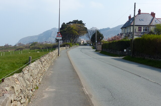
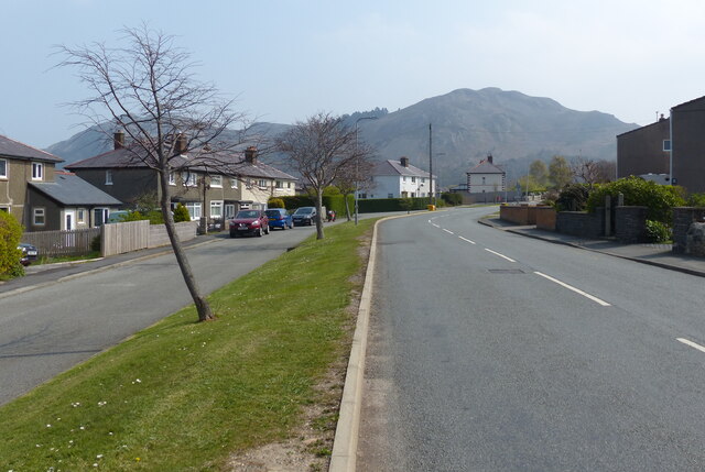
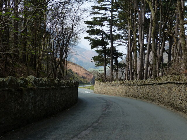
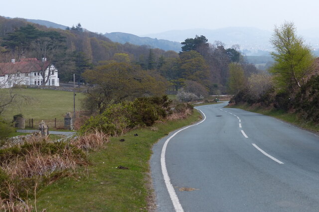
Capelulo is a small village located in the county of Caernarfonshire, Wales. Situated in the picturesque Conwy Valley, it is nestled between the towering mountains of Snowdonia National Park and the stunning North Wales coastline. The village is approximately 3 miles south of the historic town of Conwy and 13 miles north of the popular tourist destination of Llandudno.

With its idyllic setting, Capelulo offers visitors a tranquil escape from the hustle and bustle of city life. The village is characterized by its charming stone houses, traditional Welsh architecture, and friendly atmosphere. Surrounded by lush green fields and rolling hills, it is a haven for nature lovers and outdoor enthusiasts.

Capelulo is renowned for its stunning natural beauty and is a popular base for exploring the nearby Snowdonia National Park. The park offers a wealth of outdoor activities, including hiking, mountain biking, and rock climbing, with Mount Snowdon, the highest peak in Wales, just a short distance away.

Despite its small size, Capelulo boasts a close-knit community and a vibrant local culture. The village is home to a welcoming pub, serving traditional Welsh dishes and locally brewed ales, as well as a small shop providing essential amenities for residents and visitors alike.

Overall, Capelulo is a hidden gem in Caernarfonshire, offering breathtaking scenery, outdoor adventures, and a taste of rural Welsh life.

If you have any feedback on the listing, please let us know in the comments section below.

Capelulo Images

Images are sourced within 2km of 53.270352/-3.886675 or Grid Reference SH7476. Thanks to Geograph Open Source API. All images are credited.

Ysguborwen Road in Dwygyfylchi On the right is the Gladstone Bar & Grill.
Ysguborwen Road in Dwygyfylchi
On the right is the Gladstone Bar & Grill.
Houses along Ysguborwen Road in Dwygyfylchi
The parish church of St Gwynin and war memorial at Dwygyfylchi
Old Mill Road at Dwygyfylchi
Houses at the western end of the Sychnant Pass
Sheep and pasture near Dwygyfylchi
Road ascending the Sychnant Pass
Road descending the Sychnant Pass
Sychnant Pass near Capelulo
North Wales Path at the Sychnant Pass The North Wales Path is 60 miles long and connects Bangor to Prestatyn.
The western section is the more challenging, climbing onto moorlands below Moel Wnion, passing Aber Falls, and continuing below Foel Fras and Tal y Fan and then over Conwy Mountain with fine views along the coast and inland towards Snowdonia's peaks. The Great Orme and Llandudno are encircled to reach Colwyn Bay. The eastern section runs along or closer to the coast with much less ascent, passing Abergele and Rhyll to reach Prestatyn. It links with the Offa's Dyke Path National Trail, and the Clwydian Way, at Prestatyn.
North Wales Path at the Sychnant Pass
The North Wales Path is 60 miles long and connects Bangor to Prestatyn. The western section is the more challenging, climbing onto moorlands below Moel Wnion, passing Aber Falls, and continuing below Foel Fras and Tal y Fan and then over Conwy Mountain with fine views along the coast and inland towards Snowdonia's peaks. The Great Orme and Llandudno are encircled to reach Colwyn Bay. The eastern section runs along or closer to the coast with much less ascent, passing Abergele and Rhyll to reach Prestatyn. It links with the Offa's Dyke Path National Trail, and the Clwydian Way, at Prestatyn.
Road through the Sychnant Pass
Sychnant Pass Road towards Conwy On the left is the Sychnant Pass Country House Hotel.
Sychnant Pass Road towards Conwy
On the left is the Sychnant Pass Country House Hotel.
Sychnant Pass Road towards Conwy
Wales Coast Path towards Penmaenmawr The Wales Coast Path (Welsh: Llwybr Arfordir Cymru) is a long distance footpath which follows the whole of the coastline of Wales. It opened on 5 May 2012, and offers a 870 mile long route from Chepstow in the south to Queensferry in the north.
Wales is the first country in the world to provide a dedicated footpath along its entire coastline. The Path runs through eleven National Nature Reserves and other nature reserves, including those managed by The Wildlife Trusts or Royal Society for the Protection of Birds (RSPB).
Logo can be seen at<a href="https://www.geograph.org.uk/photo/3738617">SS0897 : Logo, Wales Coast Path</a>.
Website: <span class="nowrap"><a title="http://www.walescoastpath.gov.uk/default.aspx" rel="nofollow ugc noopener" href="http://www.walescoastpath.gov.uk/default.aspx">Link</a><img style="margin-left:2px;" alt="External link" title="External link - shift click to open in new window" src="https://s1.geograph.org.uk/img/external.png" width="10" height="10"/></span>
Wales Coast Path towards Penmaenmawr
The Wales Coast Path (Welsh: Llwybr Arfordir Cymru) is a long distance footpath which follows the whole of the coastline of Wales. It opened on 5 May 2012, and offers a 870 mile long route from Chepstow in the south to Queensferry in the north. Wales is the first country in the world to provide a dedicated footpath along its entire coastline. The Path runs through eleven National Nature Reserves and other nature reserves, including those managed by The Wildlife Trusts or Royal Society for the Protection of Birds (RSPB). Logo can be seen atSS0897 : Logo, Wales Coast Path. Website: LinkExternal link
North Wales coastline near Penmaenmawr
Wales Coast Path next to the Penmaen-bach Tunnel This is the eastbound side of the tunnels, heading towards Conwy.
Wales Coast Path next to the Penmaen-bach Tunnel
This is the eastbound side of the tunnels, heading towards Conwy.
Wales Coast Path towards Penmaen-bach Point The Wales Coast Path (Welsh: Llwybr Arfordir Cymru) is a long distance footpath which follows the whole of the coastline of Wales. It opened on 5 May 2012, and offers a 870 mile long route from Chepstow in the south to Queensferry in the north.
Wales is the first country in the world to provide a dedicated footpath along its entire coastline. The Path runs through eleven National Nature Reserves and other nature reserves, including those managed by The Wildlife Trusts or Royal Society for the Protection of Birds (RSPB).
Logo can be seen at<a href="https://www.geograph.org.uk/photo/3738617">SS0897 : Logo, Wales Coast Path</a>.
Website: <span class="nowrap"><a title="http://www.walescoastpath.gov.uk/default.aspx" rel="nofollow ugc noopener" href="http://www.walescoastpath.gov.uk/default.aspx">Link</a><img style="margin-left:2px;" alt="External link" title="External link - shift click to open in new window" src="https://s1.geograph.org.uk/img/external.png" width="10" height="10"/></span>
Wales Coast Path towards Penmaen-bach Point
The Wales Coast Path (Welsh: Llwybr Arfordir Cymru) is a long distance footpath which follows the whole of the coastline of Wales. It opened on 5 May 2012, and offers a 870 mile long route from Chepstow in the south to Queensferry in the north. Wales is the first country in the world to provide a dedicated footpath along its entire coastline. The Path runs through eleven National Nature Reserves and other nature reserves, including those managed by The Wildlife Trusts or Royal Society for the Protection of Birds (RSPB). Logo can be seen atSS0897 : Logo, Wales Coast Path. Website: LinkExternal link
Show me another place!

Capelulo is located at Grid Ref: SH7476 (Lat: 53.270352, Lng: -3.886675)

Unitary Authority: Conwy

Police Authority: North Wales

Also known as: Capel Ulo

What 3 Words

///steamed.rams.envisage. Near Penmaenmawr, Conwy

Nearby Locations

Capel Ulo Capelulo

Related Wikis

Sychnant Pass

Sychnant Pass (Welsh: Bwlch Sychnant, "Dry-stream Pass") in Conwy County Borough, Wales, links Conwy to Penmaenmawr via Dwygyfylchi. Much of the pass is...

Dwygyfylchi

Dwygyfylchi (Welsh: [dʊɨɡəˈvəlχi]) is a village in Conwy County Borough, Wales. It is part of the community of Penmaenmawr which has a population of 4...

Castell Caer Seion

Castell Caer Seion is an Iron Age hillfort situated at the top of Conwy Mountain, in Conwy County, North Wales. It is unusual for the fact that the main...

Mynydd y Dref

Mynydd y Dref (Welsh : "Mountain of the Town") or Conwy Mountain is a hilly area to the west of the town of Conwy, in North Wales. To the north it overlooks...

Penmaenmawr railway station

Penmaenmawr railway station serves the town of Penmaenmawr, Wales, and is located on the North Wales Coast Line travelling from Crewe to Holyhead, 49+1...

Penmaenmawr

Penmaenmawr (, Welsh: [ˈpɛnmaːɨnmaur] ) is a town and community in Conwy County Borough, Wales, which was formerly in the parish of Dwygyfylchi and the...

Llangelynnin, Conwy

Llangelynnin (; Welsh for The church of Celynnin) is a former parish in the Conwy valley, in Conwy county borough, north Wales. Today the name exists...

Conway Marsh railway station

Conway Marsh railway station (later known as Conway Morfa) was located about a mile north west of Conwy, Wales (Conway being the English name for the town...

Nearby Amenities

Located within 500m of 53.270352,-3.886675
Capelulo
Is In: Gwynedd,Cymru,Wales,UK
Place: village
Lat/Long: 53.270729/-3.8854652
Glyn
Is In: Gwynedd,Cymru,Wales,UK
Place: hamlet
Lat/Long: 53.2732983/-3.887776
Nant
Is In: Gwynedd,Cymru,Wales,UK
Place: hamlet
Lat/Long: 53.2689583/-3.8847864
Post Box
Collection Times: Mo-Fr 16:30; Sa 12:15
Operator: Royal Mail
Operator Wikidata: Q638098
Post Box Mounting: pier
Post Box Type: lamp
Ref: LL34 20
Royal Cypher: EIIR
Royal Cypher Wikidata: Q33102113
Lat/Long: 53.2712627/-3.8851554
Restaurant
The Austrian Restaurant
Addr City: Penmaenmawr
Addr Country: GB
Addr Place: Dwygyfylchi
Addr Postcode: LL34 6SP
Addr Street: Conwy Old Road
Fhrs Authority: Conwy
Fhrs Id: 457648
Fhrs Local Authority Id: 13093
Name En: The Austrian Restaurant
Lat/Long: 53.2712692/-3.8858057
Pub
Fairy Glen Hotel
Addr City: Penmaenmawr
Addr Country: GB
Addr Place: Dwygyfylchi
Addr Postcode: LL34 6SP
Addr Street: Conwy Old Road
Fhrs Authority: Conwy
Fhrs Id: 52825
Fhrs Local Authority Id: 11959
Name En: Fairy Glen Hotel
Wikidata: Q80578065
Lat/Long: 53.2712968/-3.884889
Bus Stop
Bus: yes
Public Transport: platform
Lat/Long: 53.2714106/-3.8860085
Power: substation
Lat/Long: 53.271408/-3.885427
Restaurant
Bay of Bengal
Addr City: Penmaenmawr
Addr Country: GB
Addr Place: Dwygyfylchi
Addr Postcode: LL34 6SP
Addr Street: Conwy Old Road
Fhrs Authority: Conwy
Fhrs Id: 230373
Fhrs Local Authority Id: 12664
Name Cy: Bunkers Bistro
Name En: Bay of Bengal
Lat/Long: 53.2715669/-3.8893265
Hiking: yes
Information: guidepost
Source: GPS survey
Tourism: information
Lat/Long: 53.2713031/-3.885342
Barrier: kissing_gate
Lat/Long: 53.2713584/-3.8868642
Hiking: yes
Information: guidepost
Source: GPS survey
Tourism: information
Lat/Long: 53.2706049/-3.8879659
Power: pole
Lat/Long: 53.2703358/-3.8877761
Power: pole
Lat/Long: 53.2698755/-3.8876367
Power: pole
Lat/Long: 53.2698305/-3.8876702
Hiking: yes
Information: guidepost
Source: GPS survey
Tourism: information
Lat/Long: 53.2680243/-3.88763
Direction: S
Generator Method: photovoltaic
Generator Output Electricity: yes
Generator Solar Modules: 4
Generator Source: solar
Generator Type: solar_photovoltaic_panel
Location: roof
Power: generator
Lat/Long: 53.2690606/-3.8848029
Direction: 275
Generator Method: photovoltaic
Generator Output Electricity: yes
Generator Solar Modules: 4
Generator Source: solar
Generator Type: solar_photovoltaic_panel
Location: roof
Power: generator
Lat/Long: 53.2714739/-3.8885996
Direction: 185
Generator Method: photovoltaic
Generator Output Electricity: yes
Generator Solar Modules: 10
Generator Source: solar
Generator Type: solar_photovoltaic_panel
Location: roof
Power: generator
Lat/Long: 53.2715036/-3.8886599
The data included in this document is from www.openstreetmap.org. The data is made available under ODbL.

Have you been to Capelulo?

Leave your review of Capelulo below (or comments, questions and feedback).