Balloch Wood

Wood, Forest in Kirkcudbrightshire

Scotland

Balloch Wood

Culcronchie Burn Upstream of Culcronchie Bridge.
Culcronchie Burn Credit: Richard Webb

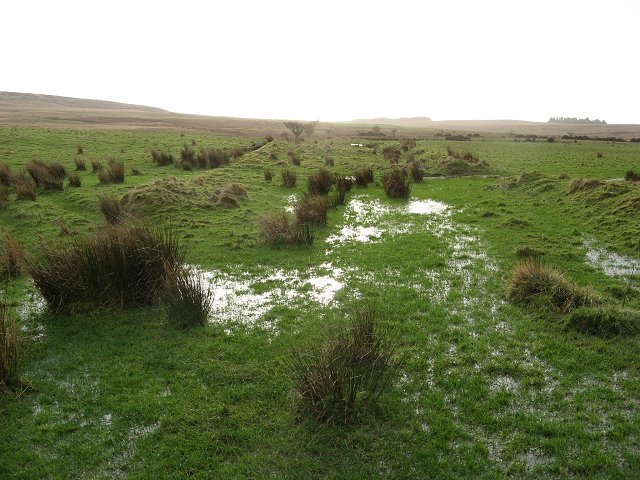
Balloch Wood is a picturesque woodland located in Kirkcudbrightshire, Scotland. Spread over an area of approximately 80 hectares, it is a haven for nature enthusiasts and outdoor lovers alike. The wood is situated near the town of Balloch, providing easy accessibility to visitors.

The woodland boasts a diverse range of flora and fauna, making it an excellent place for wildlife spotting and birdwatching. The forest is predominantly composed of native tree species such as oak, birch, and hazel, creating a rich and varied ecosystem. Bluebells carpet the forest floor in the spring, adding a burst of color to the already stunning landscape.

A network of well-maintained trails winds through Balloch Wood, allowing visitors to explore its natural beauty. These paths cater to all levels of fitness and provide breathtaking views of the surrounding countryside. Along the way, visitors may come across charming streams and small waterfalls, further enhancing the enchanting atmosphere of the wood.

Balloch Wood is also home to a variety of wildlife, including roe deer, red squirrels, and a multitude of bird species. Birdwatchers can expect to spot woodland birds such as woodpeckers, owls, and thrushes. The wood's tranquil setting and diverse habitat make it an ideal location for wildlife photography and observation.

Additionally, the wood offers picnic areas and benches, providing visitors with the opportunity to relax and soak in the peaceful ambiance. Whether it is a leisurely stroll, a family outing, or a nature photography expedition, Balloch Wood offers something for everyone, making it a must-visit destination in Kirkcudbrightshire.

If you have any feedback on the listing, please let us know in the comments section below.

Balloch Wood Images

Images are sourced within 2km of 54.907758/-4.3397679 or Grid Reference NX5059. Thanks to Geograph Open Source API. All images are credited.

Culcronchie Burn Upstream of Culcronchie Bridge.
Culcronchie Burn
Upstream of Culcronchie Bridge.
Wood-lined minor road beside Moneypool Burn Looking south-westward.
Wood-lined minor road beside Moneypool Burn
Looking south-westward.
Minor road and Culcronchie Bridge crossing Culcronchie Burn Looking eastward.
Minor road and Culcronchie Bridge crossing Culcronchie Burn
Looking eastward.
Cycle route through the hills National cycle route 7 in Galloway.
Cycle route through the hills
National cycle route 7 in Galloway.
Field by the road Cairnsmore of Fleet is seen in the distance.
Field by the road
Cairnsmore of Fleet is seen in the distance.
Forestry near Garrocher An open area obviously used as a loading area.
Forestry near Garrocher
An open area obviously used as a loading area.
Country road above Creetown With flourishing Bracken as part of the roadside vegetation.
Country road above Creetown
With flourishing Bracken as part of the roadside vegetation.
Rough grazing on Cambret Moor The TV station on Cambret Hill is on the left horizon.
Rough grazing on Cambret Moor
The TV station on Cambret Hill is on the left horizon.
Rough grassland on Cambret Moor Looking southwest over the shallow valley of the Englishman's Burn and, in the mist and drizzle in the distance, to two small plantations on Blackmyre Moor.
Rough grassland on Cambret Moor
Looking southwest over the shallow valley of the Englishman's Burn and, in the mist and drizzle in the distance, to two small plantations on Blackmyre Moor.
Garrocher Tree Farm Nursery and Christmas tree growers. Pibble Hill in the background.
Garrocher Tree Farm
Nursery and Christmas tree growers. Pibble Hill in the background.
Landscaped old sandpit A new pond dug out of an old sand and gravel pit. There is life here, a heron was hunting the margin. The banks are freshly dug, with new track marks on the road up to the pool.
Landscaped old sandpit
A new pond dug out of an old sand and gravel pit. There is life here, a heron was hunting the margin. The banks are freshly dug, with new track marks on the road up to the pool.
Billy Diamond's Bridge Narrow bridge over the Englishman's Burn. Cambret Hill on the skyline with the masts.
Billy Diamond's Bridge
Narrow bridge over the Englishman's Burn. Cambret Hill on the skyline with the masts.
Flooded ground The field drains are overloaded about where the improved land gives way to rough grazing.
Flooded ground
The field drains are overloaded about where the improved land gives way to rough grazing.
Old Military Road Military road built 1763- 1764 to facilitate rapid troop movements. Now a rough and little frequented backroad over the hills.
Old Military Road
Military road built 1763- 1764 to facilitate rapid troop movements. Now a rough and little frequented backroad over the hills.
Culcronchie Bridge Bridge over the Culcronchie Burn which joins the Moneypool Burn near here.
Culcronchie Bridge
Bridge over the Culcronchie Burn which joins the Moneypool Burn near here.
Sheep, Falbae Blackfaces on winter pasture.

A fine example of the single stone thickness Galloway drystane dyke.
Sheep, Falbae
Blackfaces on winter pasture. A fine example of the single stone thickness Galloway drystane dyke.
Clearance cairn A vast amount of backbreaking labour for man and horse. This pile of boulders is the result of winning a good field for ploughing from rough rocky Galloway hillside.
The pioneers have long since gone, but their work remains.
Clearance cairn
A vast amount of backbreaking labour for man and horse. This pile of boulders is the result of winning a good field for ploughing from rough rocky Galloway hillside. The pioneers have long since gone, but their work remains.
Moneypool Burn The burn, now a small river runs down to Creetown through wooded banks.
Moneypool Burn
The burn, now a small river runs down to Creetown through wooded banks.
Show me another place!

Balloch Wood is located at Grid Ref: NX5059 (Lat: 54.907758, Lng: -4.3397679)

Unitary Authority: Dumfries and Galloway

Police Authority: Dumfries and Galloway

What 3 Words

///gallons.translated.exotic. Near Newton Stewart, Dumfries & Galloway

Nearby Locations

Balloch Wood

Related Wikis

Glenquicken stone circle

Glenquicken stone circle or Billy Diamond's Bridge stone circle (grid reference NX50965821) is an oval stone circle with a central pillar, two miles east...

Kirkmabreck

Kirkmabreck is a civil parish in the historic county of Kirkcudbrightshire in the Dumfries and Galloway council area, Scotland. Situated in the historic...

Creetown railway station

Creetown railway station served the town of Creetown, Dumfries and Galloway, Scotland from 1861 to 1965 on the Portpatrick and Wigtownshire Joint Railway...

Creetown

Creetown (/ˈkri:tən/, sometimes /'kri:taʊn/) is a small seaside town in the Stewartry of Kirkcudbright, in Galloway in the Dumfries and Galloway council...

Have you been to Balloch Wood?

Leave your review of Balloch Wood below (or comments, questions and feedback).