Innerwell Plantation

Wood, Forest in Wigtownshire

Scotland

Innerwell Plantation

Hedges encroach on a country road Near Garlieston.
Hedges encroach on a country road Credit: Russel Wills

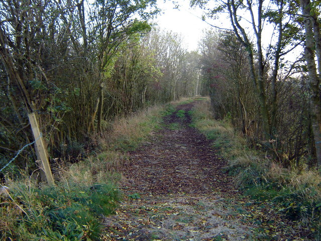
Innerwell Plantation is a picturesque woodland located in Wigtownshire, a region in southwest Scotland. Covering an area of approximately 300 acres, the plantation is situated just outside the town of Wigtown, known for its bookshops and literary festivals. The plantation is nestled amidst the rolling hills and lush green countryside of the area.

The woodland is predominantly composed of a diverse mix of deciduous and coniferous trees, creating a rich tapestry of colors throughout the year. Oak, beech, and birch trees are among the prominent species present, providing a habitat for various wildlife species. The plantation is known for its impressive bird population, with species such as buzzards, owls, and woodpeckers frequently sighted.

Innerwell Plantation offers several walking trails and paths, allowing visitors to explore the natural beauty of the area. These paths wind through the dense woodland, offering picturesque views of the surrounding landscape. The plantation is well-maintained, with clear signposts and information boards providing educational insights about the flora and fauna found within.

The woodland is a popular destination for outdoor enthusiasts and nature lovers. It offers opportunities for activities such as birdwatching, wildlife photography, and peaceful picnics amidst the serene surroundings. Additionally, the plantation is easily accessible, with ample parking facilities available for visitors.

Innerwell Plantation, with its stunning natural beauty, diverse wildlife, and tranquil ambiance, is a hidden gem in Wigtownshire, attracting visitors from near and far who seek solace in the embrace of nature.

If you have any feedback on the listing, please let us know in the comments section below.

Innerwell Plantation Images

Images are sourced within 2km of 54.819541/-4.3772379 or Grid Reference NX4749. Thanks to Geograph Open Source API. All images are credited.

Hedges encroach on a country road Near Garlieston.
Hedges encroach on a country road
Near Garlieston.
Fields near Corwar
Fields near Corwar
Field near Culscadden
Old milestone A Wigtownshire milestone near the entrance to Sorbie Farm on the B7004 leading to Garlieston.    Vegetation recently cleared by a Milestone Society member.
Old milestone
A Wigtownshire milestone near the entrance to Sorbie Farm on the B7004 leading to Garlieston. Vegetation recently cleared by a Milestone Society member.
Old milestone The Wigtown face of the milestone just northwest of the entrance to Sorbie Farm.   After 2 more miles the B7004 joins the A746 to Wigtown.
Old milestone
The Wigtown face of the milestone just northwest of the entrance to Sorbie Farm. After 2 more miles the B7004 joins the A746 to Wigtown.
Old milestone Travelling towards Garlieston the entrance to Sorbie Farm is just beyond the milestone.   Although the next milestone southwards, Garlieston 1, is marked on the map it hasn't been found.
Old milestone
Travelling towards Garlieston the entrance to Sorbie Farm is just beyond the milestone. Although the next milestone southwards, Garlieston 1, is marked on the map it hasn't been found.
Old milestone Travelling along the B7004 there are long, straight, gently undulating sections.  But it is a quiet road and easy to stop to take photographs of the milestones.
Old milestone
Travelling along the B7004 there are long, straight, gently undulating sections. But it is a quiet road and easy to stop to take photographs of the milestones.
Bluebells by the Garlieston to Innerwell path This is near Port McGean. The display of bluebells in this woodland this year is quite the most magnificent I have seen - the blooms go on for mile after mile!
Bluebells by the Garlieston to Innerwell path
This is near Port McGean. The display of bluebells in this woodland this year is quite the most magnificent I have seen - the blooms go on for mile after mile!
Bluebells on the Garlieston to Innerwell path This is near Innerwell Port. The display of bluebells in this woodland this year is quite the most magnificent I have seen - the blooms go on for mile after mile!
Bluebells on the Garlieston to Innerwell path
This is near Innerwell Port. The display of bluebells in this woodland this year is quite the most magnificent I have seen - the blooms go on for mile after mile!
New boatshed at Innerwell Port
Innerwell Cottage
Innerwell Cottage
Culscadden roadend There appears to be a farm, holiday cottages and more.
Culscadden roadend
There appears to be a farm, holiday cottages and more.
Sileage field near Culscadden
Innerwell roadend at the B7004
Access road to Sorbie Farm Entrance to Sorbie Farm on the B7004, the farm lies some distance away from the A746 road.
Access road to Sorbie Farm
Entrance to Sorbie Farm on the B7004, the farm lies some distance away from the A746 road.
Cullscadden farm road
Innerwell Port The shingle beach of Innerwell Port. The port is also a salmon fishery, the net posts can be seen on the sands at low tide.
Innerwell Port
The shingle beach of Innerwell Port. The port is also a salmon fishery, the net posts can be seen on the sands at low tide.
New Length of Wall, Innerwell Road
Show me another place!

Innerwell Plantation is located at Grid Ref: NX4749 (Lat: 54.819541, Lng: -4.3772379)

Unitary Authority: Dumfries and Galloway

Police Authority: Dumfries and Galloway

What 3 Words

///isolating.boats.kettles. Near Whithorn, Dumfries & Galloway

Nearby Locations

Innerwell Plantation

Related Wikis

Garlieston

Garlieston (Scottish Gaelic: Baile Gheàrr Lios, IPA:[ˈpaləʝeaːᵲʎis̪]) is a small planned coastal village in the historical county of Wigtownshire in Dumfries...

Garlieston railway station

Garlieston is the closed terminus of the Garlieston branch of Wigtownshire Railway; running from a junction at Millisle. It served the coastal village...

Millisle railway station

Millisle, later Millisle for Garlieston was a railway station that was near the junction for Garlieston on the Wigtownshire Railway branch line, from Newton...

Sorbie Tower

Sorbie Tower is a fortified tower house 1 mile east of the village of Sorbie, Dumfries and Galloway, Scotland. The ancient seat of the Clan Hannay, it...

Nearby Amenities

Located within 500m of 54.819541,-4.3772379
Source: PGS
Lat/Long: 54.8171722/-4.3706426
Source: PGS
Lat/Long: 54.8173268/-4.3712845
Source: PGS
Lat/Long: 54.8177727/-4.3716771
Source: PGS
Lat/Long: 54.8179521/-4.3722065
Source: PGS
Lat/Long: 54.818126/-4.3725885
Source: PGS
Lat/Long: 54.8181902/-4.3728798
Source: PGS
Lat/Long: 54.8185765/-4.3732061
Source: PGS
Lat/Long: 54.8187153/-4.3738754
Source: PGS
Lat/Long: 54.8189728/-4.3745982
Source: PGS
Lat/Long: 54.8196053/-4.3749826
Source: PGS
Lat/Long: 54.8199139/-4.3748093
Source: PGS
Lat/Long: 54.8200283/-4.3756913
Source: PGS
Lat/Long: 54.8202975/-4.3763425
Source: PGS
Lat/Long: 54.8202847/-4.3767955
Source: PGS
Lat/Long: 54.8200973/-4.3775467
Source: PGS
Lat/Long: 54.8201575/-4.3781301
Source: PGS
Lat/Long: 54.8201381/-4.3785959
Source: PGS
Lat/Long: 54.8203648/-4.3790267
Source: PGS
Lat/Long: 54.8206052/-4.3792204
Source: PGS
Lat/Long: 54.8207835/-4.3794096
Source: PGS
Lat/Long: 54.8209902/-4.3803865
Source: PGS
Lat/Long: 54.8214292/-4.3809749
Source: PGS
Lat/Long: 54.8213398/-4.381617
Source: PGS
Lat/Long: 54.8211674/-4.3819116
Source: PGS
Lat/Long: 54.8210682/-4.3821972
Source: PGS
Lat/Long: 54.8210291/-4.3827721
Source: PGS
Lat/Long: 54.8211107/-4.3832101
Source: PGS
Lat/Long: 54.8212598/-4.383771
The data included in this document is from www.openstreetmap.org. The data is made available under ODbL.

Have you been to Innerwell Plantation?

Leave your review of Innerwell Plantation below (or comments, questions and feedback).