Capel Sain Silin

Settlement in Cardiganshire

Wales

Capel Sain Silin

Gardens at Cae Hir The Welsh Garden with a Dutch History
Gardens at Cae Hir Credit: Kevin Waterhouse

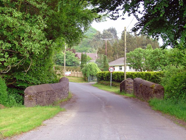
Capel Sain Silin is a small village located in the county of Cardiganshire, Wales. Situated in the picturesque landscape of rural Wales, the village is nestled in the rolling hills and surrounded by lush green fields. It is a place of tranquility and natural beauty, offering a peaceful retreat from the hustle and bustle of modern life.

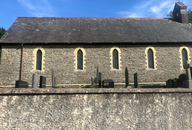
The heart of Capel Sain Silin is the historic chapel after which the village is named. Built in the 19th century, the chapel is a fine example of Welsh non-conformist architecture. It stands as a testament to the strong religious heritage of the area and serves as a focal point for the local community. Regular religious services and community events are held in the chapel, fostering a sense of unity and belonging among the villagers.

The village itself is small, with a close-knit community that takes pride in its Welsh heritage. Many of the houses in Capel Sain Silin are traditional Welsh cottages, adding to the village's charm and character. The villagers are known for their warm hospitality and friendly nature, welcoming visitors with open arms.

Surrounding the village are numerous walking trails, offering opportunities to explore the stunning countryside and take in breathtaking views. The area is also known for its rich agricultural heritage, with many farms dotting the landscape and producing locally sourced goods.

In conclusion, Capel Sain Silin is a hidden gem in the heart of Cardiganshire, offering a glimpse into the traditional Welsh way of life. With its historic chapel, picturesque surroundings, and friendly community, it is a place that captivates visitors and leaves a lasting impression.

If you have any feedback on the listing, please let us know in the comments section below.

Capel Sain Silin Images

Images are sourced within 2km of 52.136651/-4.170695 or Grid Reference SN5150. Thanks to Geograph Open Source API. All images are credited.

Gardens at Cae Hir The Welsh Garden with a Dutch History
Gardens at Cae Hir
The Welsh Garden with a Dutch History
Topiary at Cae Hir Gardens The Welsh Garden with a Dutch History
Topiary at Cae Hir Gardens
The Welsh Garden with a Dutch History
Ordnance Survey Rivet This OS rivet can be found on the south parapet of Pont Glanrafon. It marks a point 154.989m above mean sea level.
Ordnance Survey Rivet
This OS rivet can be found on the south parapet of Pont Glanrafon. It marks a point 154.989m above mean sea level.
Milestone - Cardigan 23
Ordnance Survey Cut Mark This OS cut mark can be found on the gatepost SW side of the road. It marks a point 176.013m above mean sea level.
Ordnance Survey Cut Mark
This OS cut mark can be found on the gatepost SW side of the road. It marks a point 176.013m above mean sea level.
Milestone - Cardigan 22 The Ordnance Survey cut mark on the stone marks a point 204.789m above mean sea level.
Milestone - Cardigan 22
The Ordnance Survey cut mark on the stone marks a point 204.789m above mean sea level.
Church of St Silin, Cribyn
Main road through Cribyn The B4337 Temple Bar to Llanybydder road.
Main road through Cribyn
The B4337 Temple Bar to Llanybydder road.
Semi-detached houses at Cribyn
Ordnance Survey Cut Mark This OS cut mark can be found on the house which was once the Mynach Arms. It marks a point 174.524m above mean sea level.
Ordnance Survey Cut Mark
This OS cut mark can be found on the house which was once the Mynach Arms. It marks a point 174.524m above mean sea level.
Old Milestone near Troed-y-rhiw, Llanfihangel Ystrad parish Stone post by the UC road, in parish of Llanfihangel Ystrad (Ceredigion District), Cribyn, near Capel Troedyrhiw in embankment.

Inscription reads:-
To Cardigan
22 Miles
Carved bench mark on lower face.

Grade II listed by Cadw.
Reference Number: 17440 <span class="nowrap"><a title="https://cadwpublic-api.azurewebsites.net/reports/listedbuilding/FullReport?lang=&id=17440" rel="nofollow ugc noopener" href="https://cadwpublic-api.azurewebsites.net/reports/listedbuilding/FullReport?lang=&id=17440">Link</a><img style="margin-left:2px;" alt="External link" title="External link - shift click to open in new window" src="https://s1.geograph.org.uk/img/external.png" width="10" height="10"/></span>

Surveyed

Milestone Society National ID: CRD_CACN22
Old Milestone near Troed-y-rhiw, Llanfihangel Ystrad parish
Stone post by the UC road, in parish of Llanfihangel Ystrad (Ceredigion District), Cribyn, near Capel Troedyrhiw in embankment. Inscription reads:- To Cardigan 22 Miles Carved bench mark on lower face. Grade II listed by Cadw. Reference Number: 17440 LinkExternal link Surveyed Milestone Society National ID: CRD_CACN22
Old Milepost by the B4337, Cribyn, Llanfihangel Ystrad parish Flat top casting by the B4337, Cribyn, in parish of Llanfihangel Ystrad (Ceredigion District).

Inscription reads:-
: TEMPLE BAR / 3 / MILES : : LLANYBYTHER / 5 / MILES :
Maker:-
: Eagle Foundry, Aberystwyth. :

Grade II listed by Cadw.
Reference Number: 17437 <span class="nowrap"><a title="https://cadwpublic-api.azurewebsites.net/reports/listedbuilding/FullReport?lang=&id=17437" rel="nofollow ugc noopener" href="https://cadwpublic-api.azurewebsites.net/reports/listedbuilding/FullReport?lang=&id=17437">Link</a><img style="margin-left:2px;" alt="External link" title="External link - shift click to open in new window" src="https://s1.geograph.org.uk/img/external.png" width="10" height="10"/></span>

Surveyed

Milestone Society National ID: CRD_TBLY03
Old Milepost by the B4337, Cribyn, Llanfihangel Ystrad parish
Flat top casting by the B4337, Cribyn, in parish of Llanfihangel Ystrad (Ceredigion District). Inscription reads:- : TEMPLE BAR / 3 / MILES : : LLANYBYTHER / 5 / MILES : Maker:- : Eagle Foundry, Aberystwyth. : Grade II listed by Cadw. Reference Number: 17437 LinkExternal link Surveyed Milestone Society National ID: CRD_TBLY03
Old Milestone northwest of Cribyn Milestone by the UC road, in parish of Llanfihangel Ystrad (Ceredigion District), Cribyn, by-road near Pen-wern Mills, in embankment. Damaged.

Inscription reads:-
To Cardigan
23 Miles
Carved bench mark on lower face.

Grade II listed by Cadw.
Reference Number: 17439 <span class="nowrap"><a title="https://cadwpublic-api-staging.azurewebsites.net/reports/listedbuilding/FullReport?lang=&id=17439" rel="nofollow ugc noopener" href="https://cadwpublic-api-staging.azurewebsites.net/reports/listedbuilding/FullReport?lang=&id=17439">Link</a><img style="margin-left:2px;" alt="External link" title="External link - shift click to open in new window" src="https://s1.geograph.org.uk/img/external.png" width="10" height="10"/></span>

Surveyed

Milestone Society National ID: CRD_CACN23
Old Milestone northwest of Cribyn
Milestone by the UC road, in parish of Llanfihangel Ystrad (Ceredigion District), Cribyn, by-road near Pen-wern Mills, in embankment. Damaged. Inscription reads:- To Cardigan 23 Miles Carved bench mark on lower face. Grade II listed by Cadw. Reference Number: 17439 LinkExternal link Surveyed Milestone Society National ID: CRD_CACN23
Capel Undodaidd, Cribyn Cribyn Welsh Unitarian Chapel.  
Cribyn Unitarian Chapel was built in 1790 and rebuilt in 1851. The present chapel, dated 1851, is built in the Simple Round-Headed style of the gable entry type.
Capel Undodaidd, Cribyn
Cribyn Welsh Unitarian Chapel. Cribyn Unitarian Chapel was built in 1790 and rebuilt in 1851. The present chapel, dated 1851, is built in the Simple Round-Headed style of the gable entry type.
Three Horse Shoes, Cribyn Formerly a pub but now a private residence.  Note the three horse shoes above the front door.
Three Horse Shoes, Cribyn
Formerly a pub but now a private residence. Note the three horse shoes above the front door.
Cribyn Post Office See the sign set into the wall on the corner of the property.
Cribyn Post Office
See the sign set into the wall on the corner of the property.
Ordnance Survey Cut Mark This OS cut mark can be found on the gatepost south side of the road junction. It marks a point 176.671m above mean sea level.
Ordnance Survey Cut Mark
This OS cut mark can be found on the gatepost south side of the road junction. It marks a point 176.671m above mean sea level.
Ordnance Survey Cut Mark This OS cut mark can be found on the gatepost NW side of the road. It marks a point 239.084m above mean sea level.
Ordnance Survey Cut Mark
This OS cut mark can be found on the gatepost NW side of the road. It marks a point 239.084m above mean sea level.
Show me another place!

Capel Sain Silin is located at Grid Ref: SN5150 (Lat: 52.136651, Lng: -4.170695)

Unitary Authority: Ceredigion

Police Authority: Dyfed Powys

What 3 Words

///thudded.cyclones.pulps. Near Lampeter, Ceredigion

Nearby Locations

Capel Sain Silin

Related Wikis

Cribyn

Cribyn is a small village in Ceredigion, Wales, about 7 miles (11 km) north of Lampeter and with the villages of Troed y Rhiw, Mydroilyn and Dihewyd to...

Troed y Rhiw

Troed y Rhiw (foot of the hill in English) is a hamlet in Ceredigion approximately midway between Cribyn and Dihewyd in the rolling agricultural land between...

Ffynnon-oer

Ffynnon-oer is a hamlet in the community of Llanfihangel Ystrad, Ceredigion, Wales, which is 62.6 miles (100.8 km) from Cardiff and 177.4 miles (285.6...

Gorsgoch

Gorsgoch () is a small rural village located on the B4338 road near Lampeter in the county of Ceredigion, Wales. The town of Lampeter is 7 miles away and...

Nearby Amenities

Located within 500m of 52.136651,-4.170695
Capel St Silo
Is In: Ceredigion, Wales, UK
Place: village
Source: npe
Lat/Long: 52.1364666/-4.1725958
Gaer
Historic: archaeological_site
Source: OS 7th Series
Lat/Long: 52.1362803/-4.1637332
Building: yes
Lat/Long: 52.1345606/-4.1654675
Place: farm
Lat/Long: 52.1387487/-4.1731923
Direction: SSW
Generator Method: photovoltaic
Generator Output Electricity: yes
Generator Solar Modules: 14
Generator Source: solar
Generator Type: solar_photovoltaic_panel
Location: roof
Power: generator
Lat/Long: 52.1354555/-4.1694027
Give Way
Direction: backward
Lat/Long: 52.1396607/-4.1661007
The data included in this document is from www.openstreetmap.org. The data is made available under ODbL.

Have you been to Capel Sain Silin?

Leave your review of Capel Sain Silin below (or comments, questions and feedback).