Coille Mhòr

Wood, Forest in Ross-shire

Scotland

Coille Mhòr

Forestry track below Cnoc Creagach Going from Rogie to Glensgaich.
Forestry track below Cnoc Creagach Credit: Dorothy Carse

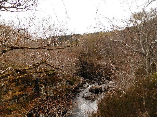
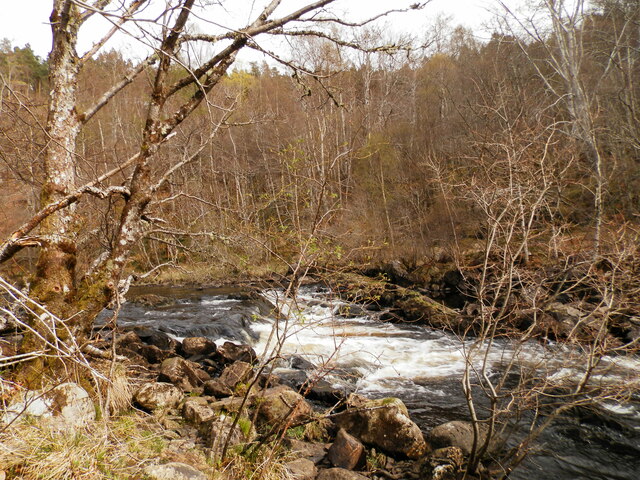
Coille Mhòr, located in Ross-shire, Scotland, is a picturesque forest that offers visitors a serene and lush natural environment. Covering an extensive area, Coille Mhòr is renowned for its diverse range of trees, including native species like oak, birch, and pine, which provide a rich tapestry of colors throughout the seasons.

The forest is home to a variety of wildlife, making it a haven for nature enthusiasts and birdwatchers. Visitors may be fortunate enough to spot red squirrels, roe deer, or even the elusive Scottish wildcat. Bird species such as golden eagles, ospreys, and crossbills can also be observed within the forest's boundaries.

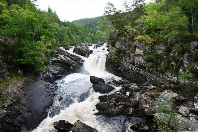
Coille Mhòr offers a network of well-maintained walking trails, allowing visitors to explore the forest at their own pace. These trails cater to all levels of fitness and range from gentle strolls to more challenging hikes. The paths are clearly signposted and provide opportunities to discover hidden gems within the forest, such as tranquil lochs and cascading waterfalls.

For those interested in the history of the area, Coille Mhòr has remnants of ancient settlements and standing stones, showcasing the region's rich archaeological heritage. Interpretive signs along the trails help visitors understand the historical significance of these sites.

Coille Mhòr is a popular destination for outdoor activities, including camping, picnicking, and wildlife photography. The forest provides a tranquil retreat away from the hustle and bustle of daily life, offering visitors a chance to reconnect with nature and enjoy the beauty of Ross-shire's woodlands.

If you have any feedback on the listing, please let us know in the comments section below.

Coille Mhòr Images

Images are sourced within 2km of 57.588244/-4.5948489 or Grid Reference NH4458. Thanks to Geograph Open Source API. All images are credited.

Forestry track below Cnoc Creagach Going from Rogie to Glensgaich.
Forestry track below Cnoc Creagach
Going from Rogie to Glensgaich.
Forestry track, Cnoc Creagach Going from Rogie to Glensgaich.
Forestry track, Cnoc Creagach
Going from Rogie to Glensgaich.
Kyle railway line below Cnoc Creagach The line is close here to one of the major forest roads through Rogie Forest.
Kyle railway line below Cnoc Creagach
The line is close here to one of the major forest roads through Rogie Forest.
Forest track below Cnoc Creagach A well maintained route through the Rogie Forest.
Forest track below Cnoc Creagach
A well maintained route through the Rogie Forest.
Upstream from Rogie Falls View across Black Water just a few metres upstream from Rogie Falls.
Upstream from Rogie Falls
View across Black Water just a few metres upstream from Rogie Falls.
Path at Rogie Falls
Path at Rogie Falls
View to Loch Kinellan A dull early November afternoon.
View to Loch Kinellan
A dull early November afternoon.
Rogie Falls. April 2022
Downstream from Rogie Falls
Rogie Falls. April 2022
Upstream from Rogie Falls
The A835 approaching Contin
The A835 north of Contin
An Dubh-lochan
An Dubh-lochan
Bridge for mountain bikes
Layby on the Eastbound A835 The A835 is a primary road in the Scottish Highlands linking Inverness to Ullapool and the Far North of Scotland. It runs for just over 66 miles, between Tore Roundabout and Ledmore (north of Ullapool)/ The road can be particularly busy before and after ferry crossings arrive at and depart from Ullapool, and sees a great deal of goods traffic travelling to and from the Western Isles (<span class="nowrap"><a title="https://www.sabre-roads.org.uk/wiki/index.php?title=A835" rel="nofollow ugc noopener" href="https://www.sabre-roads.org.uk/wiki/index.php?title=A835">Link</a><img style="margin-left:2px;" alt="External link" title="External link - shift click to open in new window" src="https://s1.geograph.org.uk/img/external.png" width="10" height="10"/></span> SABRE).
Layby on the Eastbound A835
The A835 is a primary road in the Scottish Highlands linking Inverness to Ullapool and the Far North of Scotland. It runs for just over 66 miles, between Tore Roundabout and Ledmore (north of Ullapool)/ The road can be particularly busy before and after ferry crossings arrive at and depart from Ullapool, and sees a great deal of goods traffic travelling to and from the Western Isles (LinkExternal link SABRE).
A835 at Rogie Falls Car Park The A835 is a primary road in the Scottish Highlands linking Inverness to Ullapool and the Far North of Scotland. It runs for just over 66 miles, between Tore Roundabout and Ledmore (north of Ullapool)/ The road can be particularly busy before and after ferry crossings arrive at and depart from Ullapool, and sees a great deal of goods traffic travelling to and from the Western Isles (<span class="nowrap"><a title="https://www.sabre-roads.org.uk/wiki/index.php?title=A835" rel="nofollow ugc noopener" href="https://www.sabre-roads.org.uk/wiki/index.php?title=A835">Link</a><img style="margin-left:2px;" alt="External link" title="External link - shift click to open in new window" src="https://s1.geograph.org.uk/img/external.png" width="10" height="10"/></span> SABRE).
A835 at Rogie Falls Car Park
The A835 is a primary road in the Scottish Highlands linking Inverness to Ullapool and the Far North of Scotland. It runs for just over 66 miles, between Tore Roundabout and Ledmore (north of Ullapool)/ The road can be particularly busy before and after ferry crossings arrive at and depart from Ullapool, and sees a great deal of goods traffic travelling to and from the Western Isles (LinkExternal link SABRE).
Show me another place!

Coille Mhòr is located at Grid Ref: NH4458 (Lat: 57.588244, Lng: -4.5948489)

Unitary Authority: Highland

Police Authority: Highlands and Islands

What 3 Words

///circulate.swooned.topmost. Near Strathpeffer, Highland

Nearby Locations

Coille Mhòr Tarvie Wood

Related Wikis

Rogie Falls

Rogie Falls (Gaelic: Eas Rothagaidh) are a series of waterfalls on the Black Water, a river in Ross-shire in the Highlands of Scotland. The falls are about...

Loch Achilty

Loch Achilty is a large deep picturesque lowland freshwater loch set within a sloping birch and oakwood forest, located near Contin in Easter Ross in...

Contin

Contin (Gaelic: Cunndainn) is a Ross-shire village, and a civil parish and community council area between Strathpeffer and Garve in the Highland council...

Battle of Blar Na Pairce

The Battle of Blar na Pairce (Scottish Gaelic: Blàr na Pàirce "Battle of the Park") was a Scottish clan battle that took place just outside Strathpeffer...

Nearby Amenities

Located within 500m of 57.588244,-4.5948489
Rogie Falls
Name En: Rogie Falls
Name Gd: Eas Rothagaidh
Tourism: attraction
Waterway: waterfall
Wikidata: Q7359399
Wikipedia: en:Rogie Falls
Lat/Long: 57.5891751/-4.6024988
Bench
Source: survey
Lat/Long: 57.5839087/-4.5941294
Ford: yes
Lat/Long: 57.5866212/-4.5897454
The data included in this document is from www.openstreetmap.org. The data is made available under ODbL.

Have you been to Coille Mhòr?

Leave your review of Coille Mhòr below (or comments, questions and feedback).