Mount Plantation

Wood, Forest in Ayrshire

Scotland

Mount Plantation

West Middlebank from the air With Barkip biogas power station in the background.
West Middlebank from the air Credit: Thomas Nugent

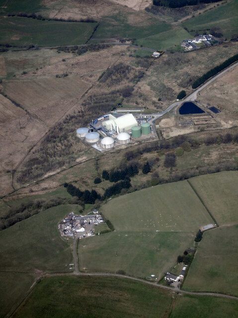
Mount Plantation is a picturesque woodland area located in Ayrshire, Scotland. Covering an area of approximately 50 acres, this forested area boasts a diverse range of trees, including oak, beech, and pine. The plantation is known for its tranquil atmosphere and stunning natural beauty, making it a popular destination for nature enthusiasts and hikers.

Visitors to Mount Plantation can enjoy a leisurely walk along the well-maintained trails that wind through the forest, taking in the sights and sounds of the surrounding wildlife. The area is home to a variety of bird species, such as woodpeckers and owls, as well as small mammals like squirrels and deer.

In addition to its natural beauty, Mount Plantation also has historical significance, with remnants of old stone walls and ruins scattered throughout the area. These relics serve as a reminder of the area's rich past and add to the charm of the woodland.

Overall, Mount Plantation is a hidden gem in Ayrshire, offering visitors a peaceful retreat from the hustle and bustle of everyday life. Whether you're looking to reconnect with nature or simply enjoy a relaxing stroll through the woods, Mount Plantation is a must-visit destination for anyone exploring the Ayrshire region.

If you have any feedback on the listing, please let us know in the comments section below.

Mount Plantation Images

Images are sourced within 2km of 55.708506/-4.6315894 or Grid Reference NS3449. Thanks to Geograph Open Source API. All images are credited.

West Middlebank from the air With Barkip biogas power station in the background.
West Middlebank from the air
With Barkip biogas power station in the background.
West Middlebank from the air With Barkip biogas power station in the background and West Giffen Cottage in the right foreground.
West Middlebank from the air
With Barkip biogas power station in the background and West Giffen Cottage in the right foreground.
Auchenmade Bridge Over the Dusk Water.
Auchenmade Bridge
Over the Dusk Water.
Dusk Water By Auchenmade Bridge.
Dusk Water
By Auchenmade Bridge.
Kilwinning from the air Dykeneuk Moss is in the foreground, Kilwinning is to the left, with Ardrossan, Saltcoats and Stevenston huddled together on the coast.
Kilwinning from the air
Dykeneuk Moss is in the foreground, Kilwinning is to the left, with Ardrossan, Saltcoats and Stevenston huddled together on the coast.
Site of Auchenmade station,1996 View NW: the abutments remain of the bridge that had carried the ex-Caledonian Railway (Lanarkshire & Ayrshire) line: Glasgow - Uplawmoor - Giffen - Ardrossan (Montgomery Pier). The station had been on the left: it closed 4/7/32 when local services west of Uplawmoor ceased, but boat trains to Ardrossan ran until 1939 and goods along here until 30/3/53.
Site of Auchenmade station,1996
View NW: the abutments remain of the bridge that had carried the ex-Caledonian Railway (Lanarkshire & Ayrshire) line: Glasgow - Uplawmoor - Giffen - Ardrossan (Montgomery Pier). The station had been on the left: it closed 4/7/32 when local services west of Uplawmoor ceased, but boat trains to Ardrossan ran until 1939 and goods along here until 30/3/53.
Bridge, Waterside A minor road crosses the remains of the Lanarkshire and Ayrshire Railway between Kilwinning and Lugton.
Bridge, Waterside
A minor road crosses the remains of the Lanarkshire and Ayrshire Railway between Kilwinning and Lugton.
Lanarkshire and Ayrshire Railway The remains of the trackbed between Lugton and Kilwinning.
Lanarkshire and Ayrshire Railway
The remains of the trackbed between Lugton and Kilwinning.
Woodland, Bankhead Blue tarpaulins cover firewood.
Woodland, Bankhead
Blue tarpaulins cover firewood.
Middlebank pasture Better looking grass than some fields around DM Beith. There is roll of old fencing wire in the foreground.
Middlebank pasture
Better looking grass than some fields around DM Beith. There is roll of old fencing wire in the foreground.
Wet depression A waterlogged hollow at East Middlebank.
Wet depression
A waterlogged hollow at East Middlebank.
Bridge Bridge carrying the road over the line of a disused railway.
Bridge
Bridge carrying the road over the line of a disused railway.
A Grey Day The road to Newhouse farm under a grey November sky.
A Grey Day
The road to Newhouse farm under a grey November sky.
Knollhead Farm Farmhouse and buildings to the east of Dalry
Knollhead Farm
Farmhouse and buildings to the east of Dalry
Dusk Water Dusk water flowing slowly westwards towards Kilwinning. Taken from the bridge on the B707
Dusk Water
Dusk water flowing slowly westwards towards Kilwinning. Taken from the bridge on the B707
B&B B&B on the junction between the B707 and the minor road in the middle of grid square NS3448
B&B
B&B on the junction between the B707 and the minor road in the middle of grid square NS3448
Sunnyside Farm Farm buildings on the B707 at Sunnyside Farm
Sunnyside Farm
Farm buildings on the B707 at Sunnyside Farm
Dykeneuk Moss Pretty featureless field shown as Dykeneuk Moss on the map
Dykeneuk Moss
Pretty featureless field shown as Dykeneuk Moss on the map
Show me another place!

Mount Plantation is located at Grid Ref: NS3449 (Lat: 55.708506, Lng: -4.6315894)

Unitary Authority: North Ayrshire

Police Authority: Ayrshire

What 3 Words

///cheater.relishes.humble. Near Beith, North Ayrshire

Nearby Locations

Mount Plantation

Related Wikis

Auchenmade railway station

Auchenmade railway station was a railway station approximately three miles (4.8 km) north-east of Kilwinning on the B707, North Ayrshire, Scotland. It...

Giffen railway station

Giffen railway station was a railway station approximately one mile south-west of the village of Barrmill, North Ayrshire, Scotland. The station was part...

Nettlehirst

Nettlehirst or Nettlehurst was a small mansion house (NS365504) and estate in the Parish of Beith, near Barrmill in North Ayrshire, Scotland. The house...

Lands of Bogston

Bogston or later Bogstone was a small estate in the old Barony of Giffen near Barrmill in the Parish of Beith, North Ayrshire, once held by collateral...

Nearby Amenities

Located within 500m of 55.708506,-4.6315894
Power: pole
Lat/Long: 55.7063041/-4.6381898
Power: pole
Lat/Long: 55.7059581/-4.6370552
Power: pole
Lat/Long: 55.7056052/-4.6359233
Power: pole
Lat/Long: 55.7055024/-4.6346198
Power: pole
Lat/Long: 55.7053996/-4.6332572
Power: pole
Lat/Long: 55.7052999/-4.6319805
Power: pole
Lat/Long: 55.7049659/-4.6308325
Power: pole
Lat/Long: 55.7046606/-4.6297489
Power: pole
Lat/Long: 55.7125653/-4.6316191
Power: pole
Lat/Long: 55.7122507/-4.6329357
Power: pole
Lat/Long: 55.7119632/-4.634169
Power: pole
Lat/Long: 55.7116346/-4.6355605
Power: pole
Lat/Long: 55.7113084/-4.6369354
Power: pole
Lat/Long: 55.7110032/-4.6382333
Power: pole
Lat/Long: 55.705643/-4.6276559
The data included in this document is from www.openstreetmap.org. The data is made available under ODbL.

Have you been to Mount Plantation?

Leave your review of Mount Plantation below (or comments, questions and feedback).