Doire na h-Achlaise

Wood, Forest in Inverness-shire

Scotland

Doire na h-Achlaise

Eastern slopes of Ben Tee The eastern slopes of Ben Tee. A rain shower is rolling in from the left. In the distance the forestry plantations on the east side of the Great Glen show up clearly.
Eastern slopes of Ben Tee Credit: Jonathan Venn

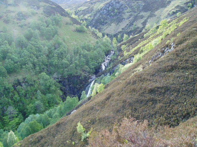
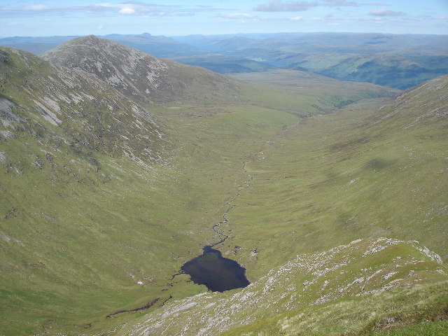
Doire na h-Achlaise, located in Inverness-shire, Scotland, is a picturesque wood or forest that offers an idyllic landscape and a haven for nature enthusiasts. Spanning an area of approximately [insert size] acres, this woodland is situated amidst the stunning Scottish Highlands.

The forest boasts a rich diversity of flora and fauna, with a varied mix of tree species dominating the landscape. Towering Scots pine trees command the majority of the woodland, their distinctive red-brown bark and dense canopy creating a serene and peaceful ambiance. Additionally, a blend of birch, oak, and ash trees can be found scattered throughout the area, adding to the overall beauty of the forest.

Doire na h-Achlaise is also home to a vibrant ecosystem, providing a habitat for numerous animal species. Red deer, roe deer, and the elusive Scottish wildcat can be spotted within the woodland, while birds such as the golden eagle, osprey, and capercaillie grace the skies above. The forest's tranquil environment serves as a breeding ground for a variety of smaller creatures, including red squirrels, pine martens, and a diverse range of insects.

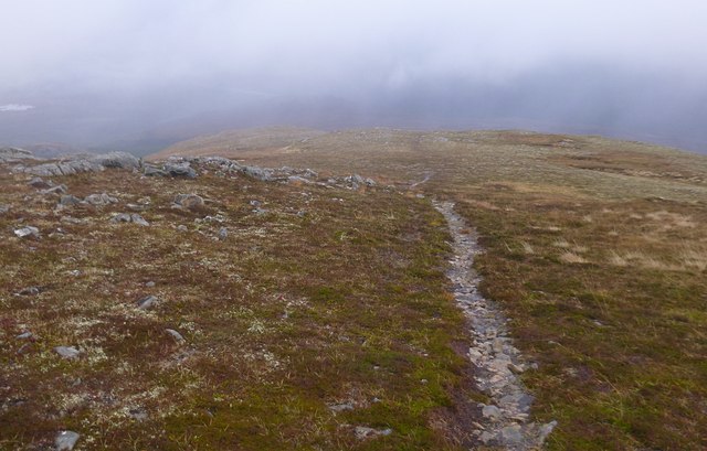
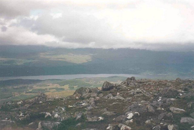
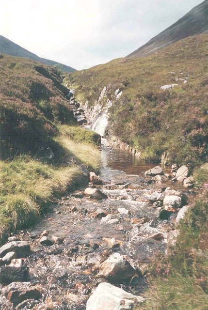
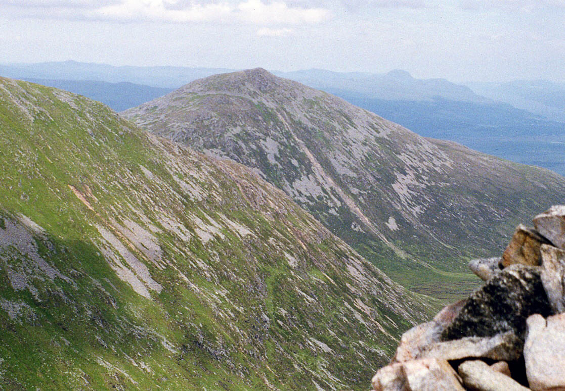
Nature enthusiasts and hikers are drawn to Doire na h-Achlaise due to its wealth of walking trails and opportunities for exploration. Visitors can indulge in leisurely strolls or more challenging hikes, immersing themselves in the natural beauty that surrounds them. The forest's captivating scenery, with its rolling hills, winding streams, and picturesque viewpoints, ensures a memorable experience for all who venture into its depths.

Overall, Doire na h-Achlaise stands as a testament to Scotland's natural allure, providing a sanctuary for both its indigenous wildlife and those seeking solace in the midst of breathtaking surroundings.

If you have any feedback on the listing, please let us know in the comments section below.

Doire na h-Achlaise Images

Images are sourced within 2km of 57.039855/-4.8834611 or Grid Reference NN2598. Thanks to Geograph Open Source API. All images are credited.

Eastern slopes of Ben Tee The eastern slopes of Ben Tee. A rain shower is rolling in from the left. In the distance the forestry plantations on the east side of the Great Glen show up clearly.
Eastern slopes of Ben Tee
The eastern slopes of Ben Tee. A rain shower is rolling in from the left. In the distance the forestry plantations on the east side of the Great Glen show up clearly.
Summit of Ben Tee On the summit of Ben Tee. Loch Garry and the Great Glen are visible in the distance.
Summit of Ben Tee
On the summit of Ben Tee. Loch Garry and the Great Glen are visible in the distance.
Ben Tee Horizontal sleet and then hail with occasional sunny spells, damp going underfoot.  This distant photo on the way to the summit captured the best view of the day.
Name: Ben Tee
Hill number: 761
Height: 904m / 2966ft
Area: 10C: Loch Arkaig to Glen Moriston
Class: Ma,C
Grid ref: NN 24067 97191
Summit feature: cairn
Drop: 356m
Col: 548m  NN233967
Ben Tee
Horizontal sleet and then hail with occasional sunny spells, damp going underfoot. This distant photo on the way to the summit captured the best view of the day. Name: Ben Tee Hill number: 761 Height: 904m / 2966ft Area: 10C: Loch Arkaig to Glen Moriston Class: Ma,C Grid ref: NN 24067 97191 Summit feature: cairn Drop: 356m Col: 548m NN233967
Path fording the Allt na Caillich Following the path up towards Ben Tee, here it crosses the Allt na Caillich. 

This was a rather wet day, so plenty of water in the stream. There are a few stepping stones, but it would be tricky to cross without getting your feet wet.
Path fording the Allt na Caillich
Following the path up towards Ben Tee, here it crosses the Allt na Caillich. This was a rather wet day, so plenty of water in the stream. There are a few stepping stones, but it would be tricky to cross without getting your feet wet.
Moorland path, on the slopes of the Ben Tee This path heads up through the forest and onto moorland, on the lower slopes of Ben Tee. It was a rather wet day, plenty of puddles on the path.

This is the view back down the hill, with Meall nan Rudhag to the left, its lower slopes covered by conifer plantation. Looking towards Invergarry and the Great Glen to the right.
Moorland path, on the slopes of the Ben Tee
This path heads up through the forest and onto moorland, on the lower slopes of Ben Tee. It was a rather wet day, plenty of puddles on the path. This is the view back down the hill, with Meall nan Rudhag to the left, its lower slopes covered by conifer plantation. Looking towards Invergarry and the Great Glen to the right.
Allt na Caillich, by Ben Tee Looking up the Allt na Caillich, with the northern slopes of Ben Tee to the left. This includes the wooded area of Doire na-Achlaise, and the point of Bac nan Laogh.

It was a rather dreich day, with much of the hill hidden in the clouds, and plenty of water in the stream.
Allt na Caillich, by Ben Tee
Looking up the Allt na Caillich, with the northern slopes of Ben Tee to the left. This includes the wooded area of Doire na-Achlaise, and the point of Bac nan Laogh. It was a rather dreich day, with much of the hill hidden in the clouds, and plenty of water in the stream.
Eastern slopes of Ben Tee An area of moorland with a mixture of heather and grass, all rather wet on this dreich day. A few sheep roaming around, surprising to see them so far up the hill (about 600m).
Lochan Dìota is visible in the clouds below.
Eastern slopes of Ben Tee
An area of moorland with a mixture of heather and grass, all rather wet on this dreich day. A few sheep roaming around, surprising to see them so far up the hill (about 600m). Lochan Dìota is visible in the clouds below.
Path down Ben Tee This narrow path runs down through rocky slopes and moorland on the eastern side of Ben Tee.

Looking towards the Great Glen and Glen Garry, most of the view obscured by clouds.
Path down Ben Tee
This narrow path runs down through rocky slopes and moorland on the eastern side of Ben Tee. Looking towards the Great Glen and Glen Garry, most of the view obscured by clouds.
Meall nan Dearcag beyond the Kilfinnan Gorge Ben Tee appears on the right in this photo with Meall nan Dearcag on the left.
Meall nan Dearcag beyond the Kilfinnan Gorge
Ben Tee appears on the right in this photo with Meall nan Dearcag on the left.
Eastern ridge of Ben Tee Cotton grass, boggy ground and a peat hag can be seen in this photo.
Eastern ridge of Ben Tee
Cotton grass, boggy ground and a peat hag can be seen in this photo.
Nearly at the top now...the summit of Ben Tee
Summit cairn, Ben Tee Ben Tee is rated as one of Scotland's better "smaller mountains" by Hamish Brown according to Wikipedia.  That said, it is not that small since it is both a Corbett and not far short of being a Munro at a height of 2,966 feet.
Summit cairn, Ben Tee
Ben Tee is rated as one of Scotland's better "smaller mountains" by Hamish Brown according to Wikipedia. That said, it is not that small since it is both a Corbett and not far short of being a Munro at a height of 2,966 feet.
Ben Tee summit view
Ben Tee summit view
Ben Tee in early evening sunshine Ben Tee is on the right in this photo.
Ben Tee in early evening sunshine
Ben Tee is on the right in this photo.
Lochan below Ben Tee This pool is on a ledge part way down the southern slope of Ben Tee.
Lochan below Ben Tee
This pool is on a ledge part way down the southern slope of Ben Tee.
Ben Tee summit Being a Corbett, and an outlier, this undervisited hill is a fine viewpoint; Loch Garry surrounded by its forests is in the glen below.
Ben Tee summit
Being a Corbett, and an outlier, this undervisited hill is a fine viewpoint; Loch Garry surrounded by its forests is in the glen below.
Allt a' Choire Ghlais A view up the young river, south of Ben Tee.
Allt a' Choire Ghlais
A view up the young river, south of Ben Tee.
Crossing Allt na Cailliche This is the main footpath to the summit of Ben Tee
Crossing Allt na Cailliche
This is the main footpath to the summit of Ben Tee
Show me another place!

Doire na h-Achlaise is located at Grid Ref: NN2598 (Lat: 57.039855, Lng: -4.8834611)

Unitary Authority: Highland

Police Authority: Highlands and Islands

What 3 Words

///ponies.chaos.give. Near Gairlochy, Highland

Nearby Locations

Doire na h-Achlaise

Related Wikis

Ben Tee

Ben Tee (Scottish Gaelic: Beinn an t-Sìthidh) is a Scottish mountain situated in the Lochaber area of the Highland council area, some 15 kilometres north...

Kilfinnan Fall

Kilfinnan Fall is a waterfall of Scotland. == See also == Waterfalls of Scotland == References ==

Coire Glas power station

Coire Glas power station is a proposed 1.5GW pumped storage hydroelectric power station in the Scottish Highlands. If built, it will double the UK's ability...

Battle of the Shirts

The Battle of the Shirts (Scottish Gaelic: Blàr na Léine, also the Battle of Kinloch-Lochy) was a Scottish clan battle that took place in 1544 in the Great...

Have you been to Doire na h-Achlaise?

Leave your review of Doire na h-Achlaise below (or comments, questions and feedback).