Dosmucheran Plantation

Wood, Forest in Ross-shire

Scotland

Dosmucheran Plantation

Slopes of Dos Mhucarain North side of Strath Bran.
Slopes of Dos Mhucarain Credit: Richard Webb

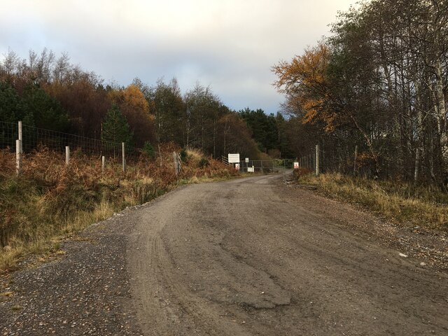
Dosmucheran Plantation is a vast woodland area located in Ross-shire, Scotland. Covering an area of approximately 500 acres, this plantation is known for its dense forests and diverse range of plant species. The woodland is primarily composed of native tree species such as oak, birch, and pine, creating a rich and vibrant ecosystem.

The plantation is a popular destination for nature lovers and outdoor enthusiasts, offering numerous walking and hiking trails that wind through the forest. Visitors can enjoy the peaceful surroundings and observe the various wildlife that call Dosmucheran Plantation home, including deer, squirrels, and a variety of bird species.

In addition to its natural beauty, Dosmucheran Plantation also has a rich history dating back to the 18th century when it was first established as a timber plantation. The estate has been carefully managed over the years to ensure the sustainability of the woodland and preserve its unique character.

Overall, Dosmucheran Plantation is a tranquil and picturesque destination that offers visitors the opportunity to immerse themselves in the beauty of Scotland's natural landscape.

If you have any feedback on the listing, please let us know in the comments section below.

Dosmucheran Plantation Images

Images are sourced within 2km of 57.591309/-5.0260134 or Grid Reference NH1959. Thanks to Geograph Open Source API. All images are credited.

Slopes of Dos Mhucarain North side of Strath Bran.
Slopes of Dos Mhucarain
North side of Strath Bran.
Bogs of Strath Bran Taken through a fence beneath the 1990s built road through the strath.
Bogs of Strath Bran
Taken through a fence beneath the 1990s built road through the strath.
Rock Pool, Sail an Tuim Bhain Inhabited by two distinct species of water boatmen
Rock Pool, Sail an Tuim Bhain
Inhabited by two distinct species of water boatmen
Druim Dubh A flat boggy plateau, seen from the path down from Sail Tuim Bhain
Druim Dubh
A flat boggy plateau, seen from the path down from Sail Tuim Bhain
Strathbran Plantation The western end of the forest, viewed from the edge of the A832.
Strathbran Plantation
The western end of the forest, viewed from the edge of the A832.
Southern slopes of Dos Mhucarain The peat in the foreground has been churned up by a large herd of deer, who make a habit of gathering here for the night.
Southern slopes of Dos Mhucarain
The peat in the foreground has been churned up by a large herd of deer, who make a habit of gathering here for the night.
Looking east along the A832 by Druimdhu
Railway and river in Strathbran Sgùrr a' Mhuilinn rises to the rear of the picture.
Railway and river in Strathbran
Sgùrr a' Mhuilinn rises to the rear of the picture.
The ruins of Camashie seen from the railway A very isolated building in Strath Bran seen in clearing weather.  The Monar mountains are bathed in sun in the far distance.
The ruins of Camashie seen from the railway
A very isolated building in Strath Bran seen in clearing weather. The Monar mountains are bathed in sun in the far distance.
River Bran near Achnasheen Tantalising for residents of Achnasheen, the weather looks sunnier further west with mountain tops in sunshine.  Seen from the Achnasheen bound train soon before its arrival.
River Bran near Achnasheen
Tantalising for residents of Achnasheen, the weather looks sunnier further west with mountain tops in sunshine. Seen from the Achnasheen bound train soon before its arrival.
Strath Bran View from An Cabar of the transport corridor. This is an easy crossing of the hills to the west coast and is used by the Kyle Line as well as the upgraded A890.
Strath Bran
View from An Cabar of the transport corridor. This is an easy crossing of the hills to the west coast and is used by the Kyle Line as well as the upgraded A890.
View towards Camashie Viewed from a passing train with the river Bran in the foreground.  Camashie is the abandoned croft in the distance - see <a href="https://www.geograph.org.uk/photo/300562">NH1858 : Ruined croft  at Camashie</a> for a closer view.
View towards Camashie
Viewed from a passing train with the river Bran in the foreground. Camashie is the abandoned croft in the distance - see NH1858 : Ruined croft at Camashie for a closer view.
A832 east of Achnasheen The A832 is a road in the Scottish Highlands, linking Cromarty, on the east coast, to Gairloch on the west coast, and beyond Gairloch to Braemore Junction. It is 126 miles long and runs entirely in the former county of Ross and Cromarty. The road forms part of the Wester Ross Coastal Trail <span class="nowrap"><a title="https://en.wikipedia.org/wiki/A832_road" rel="nofollow ugc noopener" href="https://en.wikipedia.org/wiki/A832_road">Link</a><img style="margin-left:2px;" alt="External link" title="External link - shift click to open in new window" src="https://s1.geograph.org.uk/img/external.png" width="10" height="10"/></span>  (Wikipedia).
A832 east of Achnasheen
The A832 is a road in the Scottish Highlands, linking Cromarty, on the east coast, to Gairloch on the west coast, and beyond Gairloch to Braemore Junction. It is 126 miles long and runs entirely in the former county of Ross and Cromarty. The road forms part of the Wester Ross Coastal Trail LinkExternal link (Wikipedia).
A832 near Druimdhu
A832 near Druimdhu
A832 Dosmucheran Plantation The A832 is a road in the Scottish Highlands, linking Cromarty, on the east coast, to Gairloch on the west coast, and beyond Gairloch to Braemore Junction. It is 126 miles long and runs entirely in the former county of Ross and Cromarty. The road forms part of the Wester Ross Coastal Trail <span class="nowrap"><a title="https://en.wikipedia.org/wiki/A832_road" rel="nofollow ugc noopener" href="https://en.wikipedia.org/wiki/A832_road">Link</a><img style="margin-left:2px;" alt="External link" title="External link - shift click to open in new window" src="https://s1.geograph.org.uk/img/external.png" width="10" height="10"/></span>  (Wikipedia).
A832 Dosmucheran Plantation
The A832 is a road in the Scottish Highlands, linking Cromarty, on the east coast, to Gairloch on the west coast, and beyond Gairloch to Braemore Junction. It is 126 miles long and runs entirely in the former county of Ross and Cromarty. The road forms part of the Wester Ross Coastal Trail LinkExternal link (Wikipedia).
Locked gate, Strath Bran Mesh, but far older than the usual obstacle. Possible to get over a couple of fences on the left (downhill) but a faff.
Locked gate, Strath Bran
Mesh, but far older than the usual obstacle. Possible to get over a couple of fences on the left (downhill) but a faff.
Access road for Achnasheen Quarry
A832 towards Garve
A832 towards Garve
Show me another place!

Dosmucheran Plantation is located at Grid Ref: NH1959 (Lat: 57.591309, Lng: -5.0260134)

Unitary Authority: Highland

Police Authority: Highlands and Islands

What 3 Words

///misty.trump.panics. Near Achnasheen, Highland

Nearby Locations

Dosmucheran Plantation

Related Wikis

Achnasheen

Achnasheen (Gaelic Achadh na Sìne) is a small village in Ross-shire in the Highland council area of Scotland. The village is situated on the River Bran...

Achnasheen railway station

Achnasheen railway station is a remote railway station on the Kyle of Lochalsh Line, serving the village of Achnasheen in the north of Scotland. The station...

Fionn Bheinn

Fionn Bheinn is a mountain located south of Loch Fannich in the northwestern Scottish Highlands. It has a height of 933 m (3061 ft) and is listed as a...

Loch Fannich

Loch Fannich is a remote loch in Ross-shire, in Scotland. The loch is located 19 kilometres (12 mi) west of Strathpeffer. == Etymology == The name Fannich...

Nearby Amenities

Located within 500m of 57.591309,-5.0260134
Dosmucheran
Man Made: mast
Lat/Long: 57.5913877/-5.0335972
Power: pole
Lat/Long: 57.5872173/-5.0242549
Power: pole
Lat/Long: 57.5877565/-5.0232813
Power: pole
Lat/Long: 57.5883948/-5.0221172
Power: pole
Lat/Long: 57.5890288/-5.0209612
Power: pole
Lat/Long: 57.5897232/-5.0197274
Power: pole
Lat/Long: 57.5903356/-5.0185633
The data included in this document is from www.openstreetmap.org. The data is made available under ODbL.

Have you been to Dosmucheran Plantation?

Leave your review of Dosmucheran Plantation below (or comments, questions and feedback).