Broom Park Plantation
Wood, Forest in Wigtownshire
Scotland
Broom Park Plantation
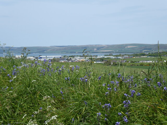
Broom Park Plantation is a picturesque woodland located in Wigtownshire, Scotland. Spread across an area of approximately 200 acres, it is a captivating destination for nature enthusiasts and those seeking tranquility amidst nature's beauty. The plantation is known for its dense and diverse forest, consisting primarily of native Scottish trees such as oak, birch, and pine.
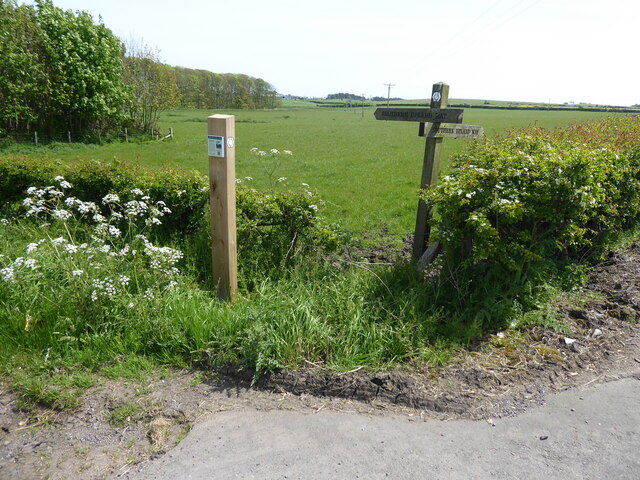
The woodland is characterized by its well-maintained walking trails that wind through the trees, offering visitors the opportunity to immerse themselves in the natural surroundings. These paths cater to both casual strollers and avid hikers, providing options for various levels of fitness and time constraints.
Broom Park Plantation is home to a rich variety of wildlife, including various bird species, small mammals, and insects. Birdwatchers will particularly enjoy the presence of native species such as woodpeckers, owls, and buzzards. The peaceful atmosphere and abundant flora also make it an ideal habitat for numerous woodland flowers and plants.
The plantation offers a range of recreational activities for visitors to enjoy. Picnic areas are available, allowing families and friends to gather and relax amidst the serenity of the woods. Additionally, the woodland is a popular spot for photography enthusiasts, who find ample opportunities to capture the beauty of the natural surroundings.
With its stunning landscape and diverse ecosystem, Broom Park Plantation is a true gem within the Wigtownshire region. Whether one seeks solitude, a family outing, or an exploration of nature, this woodland provides an ideal setting to reconnect with the natural world.
If you have any feedback on the listing, please let us know in the comments section below.
Broom Park Plantation Images
Images are sourced within 2km of 54.872941/-4.9955948 or Grid Reference NX0757. Thanks to Geograph Open Source API. All images are credited.


Broom Park Plantation is located at Grid Ref: NX0757 (Lat: 54.872941, Lng: -4.9955948)
Unitary Authority: Dumfries and Galloway
Police Authority: Dumfries and Galloway
What 3 Words
///wicket.salary.forced. Near Stranraer, Dumfries & Galloway
Nearby Locations
Related Wikis

Lochans, Dumfries and Galloway
Lochans is a small village around 2.5 miles (4.0 km) south of Stranraer, in Dumfries and Galloway in south-west Scotland. In 1971 it had a population of...
Garthland Castle
Garthland Castle was a castle that was located near Garthland Mains, Dumfries and Galloway, Scotland.The castle was possibly built in 1211, as a datestone...

Soulseat Abbey
Saulseat or Soulseat Abbey was a Premonstratensian monastic community located in Wigtownshire, Galloway, in the Gaelic-speaking south-west of Scotland...
Aird, Dumfries and Galloway
Aird (Gaelic:An Àird) is a village in Dumfries and Galloway, in the southwest of Scotland. It is 2.5 miles (4.0 km) east of Stranraer and 1 mile (1.6 km...

Galloway Community Hospital
The Galloway Community Hospital is a small hospital in Stranraer, Galloway, Scotland. It is managed by NHS Dumfries and Galloway. == History == The hospital...

Stranraer Town railway station
Stranraer Town railway station, located in Wigtownshire, Scotland, served the town of Stranraer and was a station on the Portpatrick and Wigtownshire Joint...

Stair Park
Stair Park is a public park and football stadium in the town of Stranraer, Scotland and is the home of Stranraer F.C. It is owned by Dumfries and Galloway...

Castle Kennedy railway station
Castle Kennedy railway station served the village of Castle Kennedy, Dumfries and Galloway, Scotland from 1861 to 1965 on the Portpatrick and Wigtownshire...
Nearby Amenities
Located within 500m of 54.872941,-4.9955948Have you been to Broom Park Plantation?
Leave your review of Broom Park Plantation below (or comments, questions and feedback).