Badan Darach

Wood, Forest in Argyllshire

Scotland

Badan Darach

Farm track to Gleann na h-Iola
Farm track to Gleann na h-Iola Credit: Steven Brown

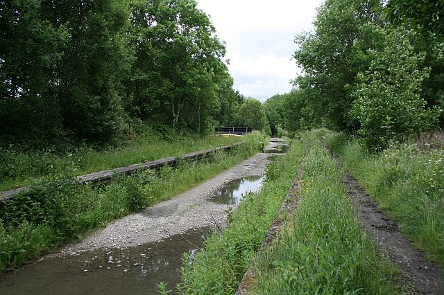
Badan Darach, located in the region of Argyllshire, Scotland, is a beautiful and pristine woodland area known for its dense forests and towering oak trees. The name "Badan Darach" translates to "Wood" or "Forest" in Scottish Gaelic, which perfectly captures the essence of this enchanting location.

Covering a significant area, Badan Darach boasts a diverse range of flora and fauna, making it a haven for nature enthusiasts and wildlife lovers. The forest floor is adorned with a vibrant carpet of moss and ferns, while majestic oak trees dominate the landscape, their branches reaching towards the sky. The rich biodiversity supports an array of wildlife, including deer, red squirrels, and various bird species, providing ample opportunities for observing and appreciating the natural world.

Badan Darach is also notable for its historical significance, with remnants of ancient settlements and stone structures scattered throughout the forest. These archaeological remains offer a glimpse into the area's past and provide a sense of connection to those who have inhabited the land for centuries.

Visitors to Badan Darach can enjoy a range of outdoor activities, such as hiking, birdwatching, and photography. There are well-maintained trails that wind through the forest, allowing visitors to immerse themselves in the tranquility and beauty of the surroundings. Whether exploring the woodland on foot or simply taking in the breathtaking scenery, Badan Darach offers a peaceful retreat for those seeking solace in nature.

Overall, Badan Darach in Argyllshire is a captivating woodland sanctuary, showcasing the natural splendor and historical significance of the region.

If you have any feedback on the listing, please let us know in the comments section below.

Badan Darach Images

Images are sourced within 2km of 56.558779/-5.3277621 or Grid Reference NM9545. Thanks to Geograph Open Source API. All images are credited.

Farm track to Gleann na h-Iola
Disused railway bridge in Strath of Appin
Farm track in Gleann na h-Iola
Disused railway trackbed near Creagan
Forestry road near Appin
National Cycle Route 78
Creagan Station From A828 On the Callander and Oban Railway Ballachulish Branch the station opened on 20th August 1903 and the 27 mile branch closed on 28th March 1966, goods traffic having been withdrawn on 14th June 1965. Having a passing loop, Creagan was the only station with an island platform on the branch. A signal box was provided at Creagan station when the Ballachulish branch opened with 16 working and 4 spare levers and 1 space although it was taken out of use on 1st April 1927. Ground frames were provided to work the connections to the former Up Loop. The sidings and ground frames were removed on 10th August 1964. The station was renovated by Appin Holiday Homes.
Creagan Station From A828
On the Callander and Oban Railway Ballachulish Branch the station opened on 20th August 1903 and the 27 mile branch closed on 28th March 1966, goods traffic having been withdrawn on 14th June 1965. Having a passing loop, Creagan was the only station with an island platform on the branch. A signal box was provided at Creagan station when the Ballachulish branch opened with 16 working and 4 spare levers and 1 space although it was taken out of use on 1st April 1927. Ground frames were provided to work the connections to the former Up Loop. The sidings and ground frames were removed on 10th August 1964. The station was renovated by Appin Holiday Homes.
Minor road near Inverfolla
A828 passing through Appin
A828 bridge just north of Appin Crossing one of the burns flowing into Loch Laich.
A828 bridge just north of Appin
Crossing one of the burns flowing into Loch Laich.
A828 running through the Strath of Appin
Appin Old Parish Church, Kinlochlaich Old parish church replaced by church at Tynribbie
Appin Old Parish Church, Kinlochlaich
Old parish church replaced by church at Tynribbie
Roadside ruin, Strath of Appin
Creagan railway station (site), Argyll and Bute Opened in 1903 on the Callander & Oban Railway's branch line from Connel Ferry to Ballachulish, this station closed in 1966. 
View east towards Barcaldine and Connel Ferry. The station site was located in a caravan park when this image was taken.
Creagan railway station (site), Argyll and Bute
Opened in 1903 on the Callander & Oban Railway's branch line from Connel Ferry to Ballachulish, this station closed in 1966. View east towards Barcaldine and Connel Ferry. The station site was located in a caravan park when this image was taken.
Early morning on the camping ground
Caledonia Way at Appin The Caledonia Way (National Cycle Network route 78) runs from Campbeltown to Inverness. Over the section between Oban and Fort William it makes much use of the trackbed of the old Oban to Ballachulish railway (closed 1966). A distinctive feature of the route are the wrought iron access controls - every one different.
Caledonia Way at Appin
The Caledonia Way (National Cycle Network route 78) runs from Campbeltown to Inverness. Over the section between Oban and Fort William it makes much use of the trackbed of the old Oban to Ballachulish railway (closed 1966). A distinctive feature of the route are the wrought iron access controls - every one different.
Show me another place!

Badan Darach is located at Grid Ref: NM9545 (Lat: 56.558779, Lng: -5.3277621)

Unitary Authority: Argyll and Bute

Police Authority: Argyll and West Dunbartonshire

What 3 Words

///arriving.tango.sharpen. Near Oban, Argyll & Bute

Nearby Locations

Badan Darach

Related Wikis

Creagan railway station

Creagan was a railway station located on the north shore of Loch Creran 1⁄4 mile (400 m) north of the Creagan Inn in Argyll and Bute. It was on the Ballachulish...

Appin

Appin (Scottish Gaelic: An Apainn) is a coastal district of the Scottish West Highlands bounded to the west by Loch Linnhe, to the south by Loch Creran...

Creagan Bridge

Creagan Bridge is a bridge that crosses Loch Creran at Creagan in Scotland. It is a road bridge that uses the supporting columns of a former railway viaduct...

Barcaldine railway station

Barcaldine was a railway station located in Barcaldine, Argyll and Bute, near the southern shore of Loch Creran. It was on the Ballachulish branch line...

Appin railway station

Appin was a railway station in Scotland, close to the Sound of Shuna on the east shore of Loch Laiche - an arm of Loch Linnhe, Portnacroish, Appin in Argyll...

Loch Creran

Loch Creran is a sea loch in Argyll, on the west coast of Scotland. It is about 10 kilometres (6.2 mi) long from its head at Invercreran to its mouth on...

Castle Stalker

Castle Stalker (Scottish Gaelic: Caisteal an Stalcaire) is a four-storey tower house or keep in the Scottish county Argyll. It is set on a tidal islet...

Barcaldine, Argyll

Barcaldine (Scottish Gaelic: Am Barra Calltainn) is a small settlement in Scotland centred on the historic Barcaldine House and located on the banks of...

Nearby Amenities

Located within 500m of 56.558779,-5.3277621
Power: pole
Lat/Long: 56.5549075/-5.3246999
Power: pole
Lat/Long: 56.5551633/-5.3258412
Power: pole
Lat/Long: 56.5554308/-5.3270482
Power: pole
Lat/Long: 56.5557117/-5.3282055
Power: pole
Lat/Long: 56.555963/-5.3293642
Power: pole
Lat/Long: 56.5561788/-5.3305337
Power: pole
Lat/Long: 56.5563799/-5.33173
Power: pole
Lat/Long: 56.5566149/-5.3329128
Power: pole
Lat/Long: 56.5567213/-5.3343907
Power: pole
Lat/Long: 56.5553893/-5.3329873
Power: pole
Lat/Long: 56.5561165/-5.3329703
The data included in this document is from www.openstreetmap.org. The data is made available under ODbL.

Have you been to Badan Darach?

Leave your review of Badan Darach below (or comments, questions and feedback).