Cave Wood

Wood, Forest in Monmouthshire

Wales

Cave Wood

West down Castleford Hill, Tutshill, Gloucestershire Viewed from a bend in the B4228.
West down Castleford Hill, Tutshill, Gloucestershire Credit: Jaggery

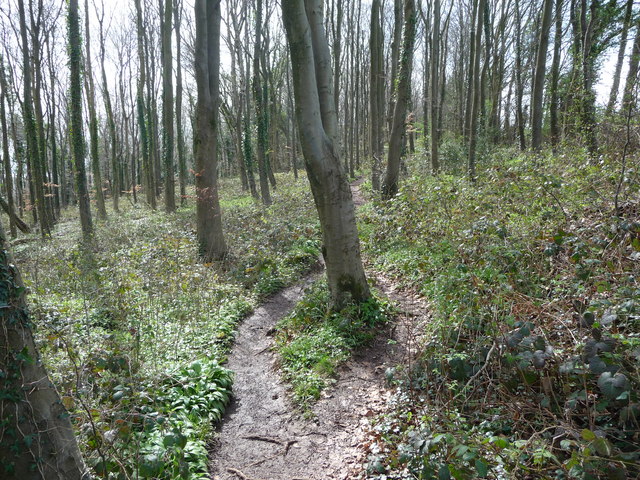
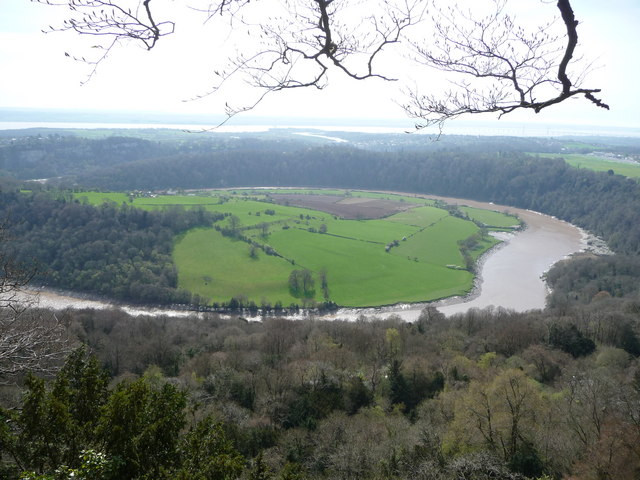
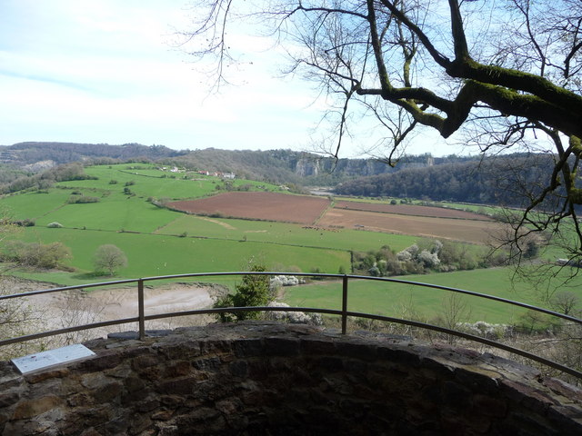
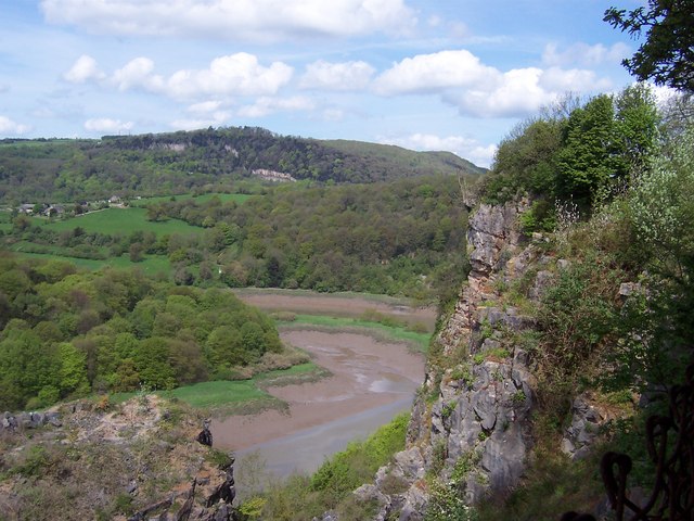
Cave Wood is a picturesque woodland located in Monmouthshire, Wales. This ancient forest covers an area of approximately 100 acres and is renowned for its natural beauty and rich biodiversity. It is situated near the village of Trellech, just a few miles from the border with England.

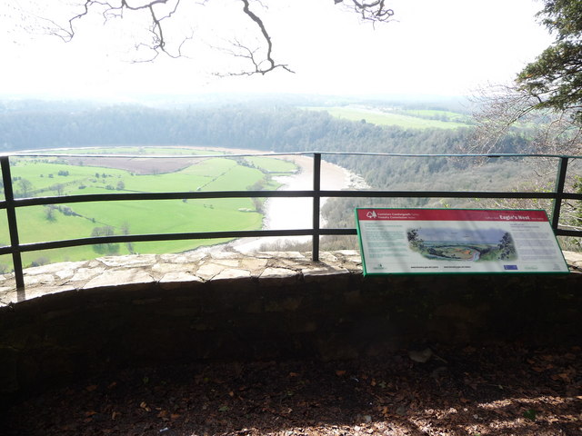
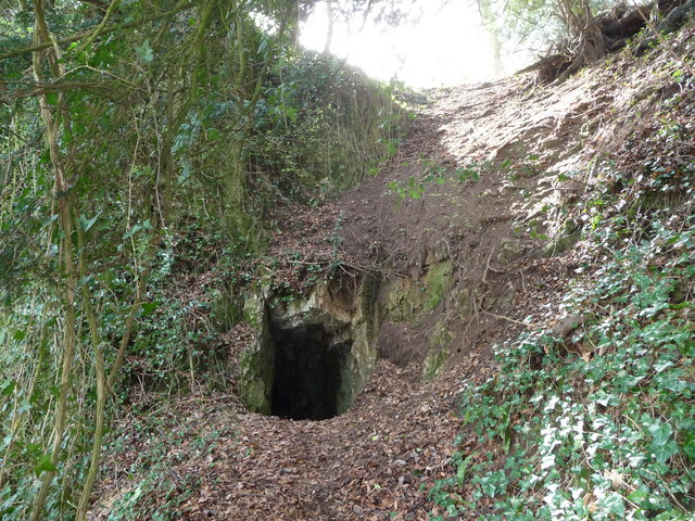
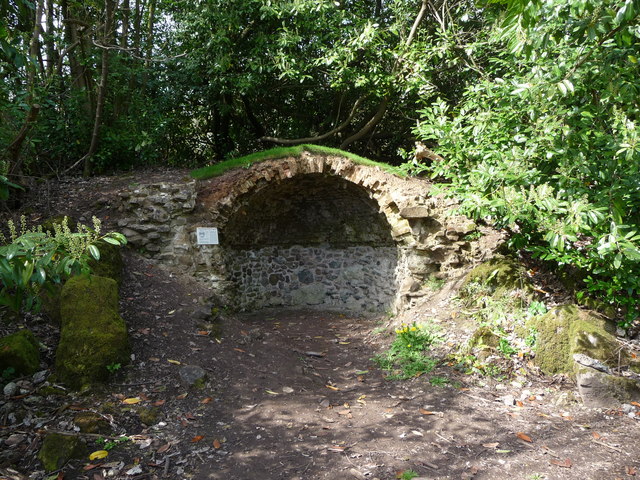
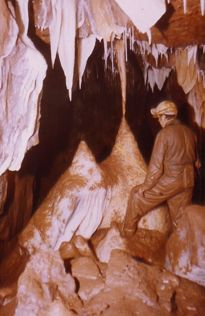
The wood gets its name from the several limestone caves that are scattered throughout the area. These caves have been formed over thousands of years through the erosion of the limestone rock by underground streams. They provide a fascinating glimpse into the geological history of the region and are a popular attraction for visitors.

Cave Wood is predominantly made up of native broadleaf trees, including oak, beech, and ash. The forest floor is covered with a diverse array of plants, such as bluebells, wild garlic, and wood anemones, which create a vibrant carpet of colors during the spring months.

The woodland is home to a wide variety of wildlife, including numerous bird species, such as woodpeckers, owls, and warblers. Small mammals, such as badgers, foxes, and squirrels, can also be spotted in the area. Additionally, Cave Wood is known for its rich insect population, including butterflies and beetles.

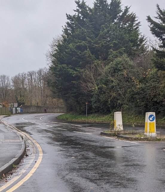
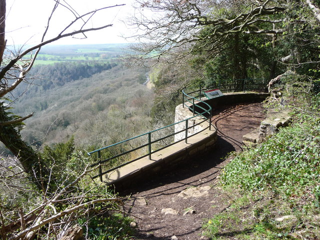
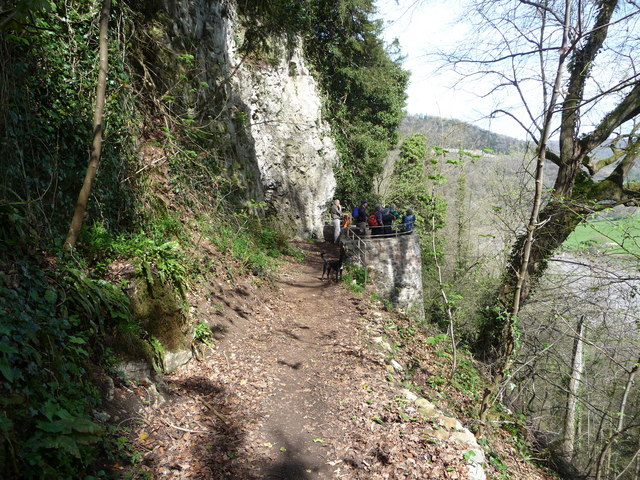
The wood offers several walking trails that allow visitors to explore its natural wonders. These paths wind through the forest, passing by the caves and offering breathtaking views of the surrounding countryside. Cave Wood is a cherished natural treasure in Monmouthshire and attracts nature enthusiasts, hikers, and photographers from near and far.

If you have any feedback on the listing, please let us know in the comments section below.

Cave Wood Images

Images are sourced within 2km of 51.661176/-2.6868034 or Grid Reference ST5296. Thanks to Geograph Open Source API. All images are credited.

West down Castleford Hill, Tutshill, Gloucestershire Viewed from a bend in the B4228.
West down Castleford Hill, Tutshill, Gloucestershire
Viewed from a bend in the B4228.
Alvington 6 Lydney 8 Direction and distances sign at the top of Castleford Hill in Tutshill.
Alvington 6 Lydney 8
Direction and distances sign at the top of Castleford Hill in Tutshill.
In the interest of hygiene NO DOGS ALLOWED, Tutshill, Gloucestershire Notice on recreation ground perimeter railings facing the B4228 Coleford Road.
In the interest of hygiene NO DOGS ALLOWED, Tutshill, Gloucestershire
Notice on recreation ground perimeter railings facing the B4228 Coleford Road.
Tidenham War Memorial Hall nameplate, Tutshill, Gloucestershire Facing the B4228 Coleford Road near the Mopla Road junction. Tutshill is a village 
in the parish of Tidenham in the Forest of Dean district of Gloucestershire.
Tidenham War Memorial Hall nameplate, Tutshill, Gloucestershire
Facing the B4228 Coleford Road near the Mopla Road junction. Tutshill is a village in the parish of Tidenham in the Forest of Dean district of Gloucestershire.
Tidenham Parish Council noticeboard, Tutshill, Gloucestershire The board outside Tidenham War Memorial Hall faces the B4228 Coleford Road.
Tutshill is a village in the parish of Tidenham in the Forest of Dean district 
of Gloucestershire. A Tutshill Community Preschool nameboard is on the right.
Tidenham Parish Council noticeboard, Tutshill, Gloucestershire
The board outside Tidenham War Memorial Hall faces the B4228 Coleford Road. Tutshill is a village in the parish of Tidenham in the Forest of Dean district of Gloucestershire. A Tutshill Community Preschool nameboard is on the right.
Slimming World banner, Tutshill, Gloucestershire Facing the B4228 Coleford Road near Tidenham War Memorial Hall.
Slimming World banner, Tutshill, Gloucestershire
Facing the B4228 Coleford Road near Tidenham War Memorial Hall.
Poppies on a Coleford Road bus shelter, Tutshill, Gloucestershire In November 2023.
Poppies on a Coleford Road bus shelter, Tutshill, Gloucestershire
In November 2023.
Wide field gate, Tutshill, Gloucestershire Alongside the B4228 Coleford Road.
Wide field gate, Tutshill, Gloucestershire
Alongside the B4228 Coleford Road.
Dead leaves, Tutshill, Gloucestershire On the pavement near Tutshill C of E Primary School in November 2023.
Dead leaves, Tutshill, Gloucestershire
On the pavement near Tutshill C of E Primary School in November 2023.
Keep the zig zags clear, Tutshill, Gloucestershire Banner on Tutshill Church of England Primary School perimeter 
railings  viewed from the B4228 Coleford Road in November 2023.
Keep the zig zags clear, Tutshill, Gloucestershire
Banner on Tutshill Church of England Primary School perimeter railings viewed from the B4228 Coleford Road in November 2023.
Part of the Wye Valley Walk in Wyndcliff wood If there is one criticism of the WVW in this section it is that you don't get to see much of the River Wye, but, you do get to see varied woodlands, and an  appreciation of the valley's history, geology, ecology and industrial heritage.
Part of the Wye Valley Walk in Wyndcliff wood
If there is one criticism of the WVW in this section it is that you don't get to see much of the River Wye, but, you do get to see varied woodlands, and an appreciation of the valley's history, geology, ecology and industrial heritage.
The Eagle's Nest viewpoint on the Wynd Cliff The information board fitted by the Forestry Commission tells of how this viewpoint got its name and what can be viewed. A beautiful spot that I never tire of revisiting.
The Eagle's Nest viewpoint on the Wynd Cliff
The information board fitted by the Forestry Commission tells of how this viewpoint got its name and what can be viewed. A beautiful spot that I never tire of revisiting.
The Lancaut peninsula from the Eagle's Nest The huge curve in the Wye is a well-known view with Chepstow and the Severn Bridges beyond.
The Lancaut peninsula from the Eagle's Nest
The huge curve in the Wye is a well-known view with Chepstow and the Severn Bridges beyond.
The Eagle's Nest An excellent spot for a rest, a brew and some lunch.
The Eagle's Nest
An excellent spot for a rest, a brew and some lunch.
A group of walkers at the Giant's Cave in the Wye Valley This group of retired walkers were enjoying the viewing platform just outside the Giant's Cave as I approached and was spotted by their little dog. They were a mix of local and not so local fellers who were enjoying their firm friendships, relaxed banter, outdoor exercise and the good weather. Not a bad way to spend some of your retirement.
A group of walkers at the Giant's Cave in the Wye Valley
This group of retired walkers were enjoying the viewing platform just outside the Giant's Cave as I approached and was spotted by their little dog. They were a mix of local and not so local fellers who were enjoying their firm friendships, relaxed banter, outdoor exercise and the good weather. Not a bad way to spend some of your retirement.
The northern entrance to the Giant's Cave on the Wye Valley Walk Yes, you are expected to enter or exit through this aperture. It's easier and more fun than it looks. One of many interesting features on this section of the WVW.
The northern entrance to the Giant's Cave on the Wye Valley Walk
Yes, you are expected to enter or exit through this aperture. It's easier and more fun than it looks. One of many interesting features on this section of the WVW.
View from the Giant's Cave viewing platform The view across the graceful curve of the River Wye onto the Lancaut peninsula and above that up to Wintour's Leap and the great cliffs near Woodcroft.
View from the Giant's Cave viewing platform
The view across the graceful curve of the River Wye onto the Lancaut peninsula and above that up to Wintour's Leap and the great cliffs near Woodcroft.
The Grotto in Piercefield Woods This feature, along with several others on a similar 'Romantic' theme, was installed in Piercefield Park and woods and comprised part of a tour through this area between around 1760 and maybe the 1820's. Gentry came from various parts of the country and toured the Wye Valley inspecting folly's, caves, walks, viewpoints and landscapes and often recording their opinions and thoughts in journals and publications. Originally this grotto was of course larger, more complete and lined inside with 'glittering crystalline minerals, glass fragments and iron and copper slag'. This would have created an elaborate decorated effect intended to mimic naturally occurring outcrops. I'm glad to see the Piercefield Walks features receiving some improvement.
The Grotto in Piercefield Woods
This feature, along with several others on a similar 'Romantic' theme, was installed in Piercefield Park and woods and comprised part of a tour through this area between around 1760 and maybe the 1820's. Gentry came from various parts of the country and toured the Wye Valley inspecting folly's, caves, walks, viewpoints and landscapes and often recording their opinions and thoughts in journals and publications. Originally this grotto was of course larger, more complete and lined inside with 'glittering crystalline minerals, glass fragments and iron and copper slag'. This would have created an elaborate decorated effect intended to mimic naturally occurring outcrops. I'm glad to see the Piercefield Walks features receiving some improvement.
Show me another place!

Cave Wood is located at Grid Ref: ST5296 (Lat: 51.661176, Lng: -2.6868034)

Unitary Authority: Monmouthshire

Police Authority: Gwent

What 3 Words

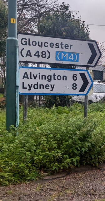
///lend.unable.breached. Near Chepstow, Monmouthshire

Related Wikis

Otter Hole

Otter Hole is perhaps one of the best decorated caves in Britain. Located on the Wales–England border just north of Chepstow, the cave runs from the banks...

Green Gathering

The Green Gathering, formerly known as the Big Green Gathering is a festival with an environmental and social justice focus, including workshops and talks...

Piercefield House

Piercefield House is a largely ruined neo-classical country house near St Arvans, Monmouthshire, Wales, about 1.5 miles (2.4 km) north of the centre of...

Chepstow Racecourse

Chepstow Racecourse is a thoroughbred horse racing course located just north of the town of Chepstow in Monmouthshire, Wales, near the southern end of...

St. Arvans

St. Arvans (Welsh: Sain Arfan or Llanarfan) is a village and community (equivalent to a parish) in Monmouthshire, south-east Wales. It is located two miles...

Lancaut

Lancaut (Welsh: Llan Cewydd) is a deserted village and former civil parish, now in the parish of Tidenham, in the Forest of Dean district, in Gloucestershire...

Wintour's Leap

Wintour's Leap is a noted rock climbing location and viewpoint. It is located near the village of Woodcroft in Gloucestershire, on the English side of...

Wyndcliff

The Wyndcliff or Wynd Cliff (historically sometimes spelt Wyndcliffe) is a steep limestone cliff rising above the western bank of the River Wye in Monmouthshire...

Related Videos

Chepstow circular walk 9 miles

Chepstow walkers are welcome. Mull Wine and Mince Pies.

Chepstow Castle #shorts

Chepstow Castle: https://youtu.be/8PxbJC8oSbk To donate and support our channel: ...

Wales, Chepstow Castle and Tintern Abbey

Chepstow is a fantastic town on the Welsh Borders. Located on the River Wye in South Wales, it is easy to visit from London by car ...

Nearby Amenities

Located within 500m of 51.661176,-2.6868034
Source: PGS
Lat/Long: 51.659344/-2.680415
Source: PGS
Lat/Long: 51.6595083/-2.6814623
Source: PGS
Lat/Long: 51.6598973/-2.6833905
Source: PGS
Lat/Long: 51.6608597/-2.6859654
Source: PGS
Lat/Long: 51.6615392/-2.6865758
Source: PGS
Lat/Long: 51.6621417/-2.6869693
Source: PGS
Lat/Long: 51.6626372/-2.6871997
Source: PGS
Lat/Long: 51.6630441/-2.6872697
Source: PGS
Lat/Long: 51.6635153/-2.6872786
Source: PGS
Lat/Long: 51.6640051/-2.687104
Source: PGS
Lat/Long: 51.6648031/-2.6867545
Source: PGS
Lat/Long: 51.6650901/-2.6865149
Source: PGS
Lat/Long: 51.6650862/-2.6845171
Source: PGS
Lat/Long: 51.6644376/-2.6845653
Source: PGS
Lat/Long: 51.6639816/-2.6845894
Source: PGS
Lat/Long: 51.6639796/-2.684917
Source: PGS
Lat/Long: 51.6634833/-2.6853847
Source: PGS
Lat/Long: 51.6625099/-2.6854911
Source: PGS
Lat/Long: 51.6620389/-2.6851197
Source: PGS
Lat/Long: 51.6617013/-2.6846082
Source: PGS
Lat/Long: 51.6613602/-2.6837643
Source: PGS
Lat/Long: 51.6611231/-2.682869
Source: PGS
Lat/Long: 51.6609143/-2.6828795
Source: PGS
Lat/Long: 51.6606539/-2.6820418
Source: PGS
Lat/Long: 51.6604484/-2.6810186
The Giant's Cave
Direction: 90
Tourism: viewpoint
Lat/Long: 51.6632933/-2.6886622
Otter Cave
Natural: cave_entrance
Wikidata: Q7109388
Wikipedia: en:Otter Hole
Lat/Long: 51.6621454/-2.6883744
Barrier: stile
Foot: yes
Lat/Long: 51.6629387/-2.6890797
Barrier: stile
Lat/Long: 51.6583161/-2.682606
The Giant's Cave
Direction: 270
Information: board
Tourism: information
Lat/Long: 51.663292/-2.6886377
The data included in this document is from www.openstreetmap.org. The data is made available under ODbL.

Have you been to Cave Wood?

Leave your review of Cave Wood below (or comments, questions and feedback).