Plantation Wood

Wood, Forest in Monmouthshire

Wales

Plantation Wood

Footpath to The Farm It does what it says on the sign!
Footpath to The Farm Credit: Jonathan Billinger

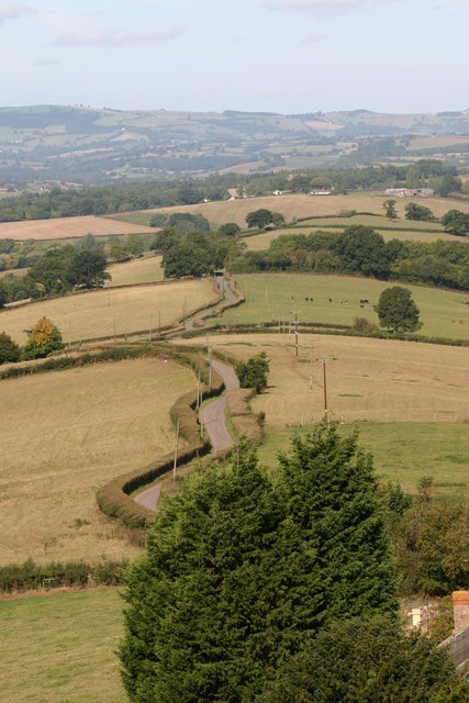
Plantation Wood is a picturesque forest located in Monmouthshire, Wales. Spanning over a vast area, this woodland is a popular destination for nature enthusiasts and hikers alike. The forest is known for its diverse range of flora and fauna, providing a haven for wildlife in the region.

The wood is primarily composed of deciduous trees, such as oak, beech, and ash, which create a stunning display of colors during the autumn months. The dense canopy formed by these trees provides shade and creates a tranquil atmosphere, making it an ideal spot for a leisurely stroll or a peaceful picnic.

Several well-marked trails wind through the forest, allowing visitors to explore its beauty at their own pace. These paths offer glimpses of rare and indigenous plants, making it an excellent destination for botany enthusiasts. The forest is also home to a variety of wildlife, including deer, foxes, and numerous bird species, making it a popular destination for birdwatchers and wildlife photographers.

Visitors to Plantation Wood can enjoy the peaceful surroundings, listen to the soothing sounds of nature, and breathe in the fresh air. The forest offers a sense of tranquility, making it a perfect escape from the hustle and bustle of daily life.

Overall, Plantation Wood in Monmouthshire is a stunning natural landscape that provides a serene and enchanting environment for visitors. Its diverse range of plant and animal species, well-maintained trails, and peaceful ambiance make it a must-visit destination for nature lovers seeking solace in the heart of Wales.

If you have any feedback on the listing, please let us know in the comments section below.

Plantation Wood Images

Images are sourced within 2km of 51.764383/-2.74507 or Grid Reference SO4807. Thanks to Geograph Open Source API. All images are credited.

Footpath to The Farm It does what it says on the sign!
Footpath to The Farm
It does what it says on the sign!
B4293 to Trellech A damaged bus stop sign.
B4293 to Trellech
A damaged bus stop sign.
Private drive, public footpath Leading to Loysey which seems to be completely surrounded by Loysey Wood.
Private drive, public footpath
Leading to Loysey which seems to be completely surrounded by Loysey Wood.
Bridleway to Loysey, 2016 The same path as <a href="https://www.geograph.org.uk/photo/324044">SO4805 : Bridleway to Loysey</a>, nine years later.
Bridleway to Loysey, 2016
The same path as SO4805 : Bridleway to Loysey, nine years later.
Edge of woodland The bridleway heads to the nearest corner of the wood and then follows its edge to the right.
Edge of woodland
The bridleway heads to the nearest corner of the wood and then follows its edge to the right.
Pasture and woodland Looking across to the top edge of Croes-Robert Wood.
Pasture and woodland
Looking across to the top edge of Croes-Robert Wood.
Lane on Cwmcarfan Hill Looking west.
Lane on Cwmcarfan Hill
Looking west.
Monmouthshire lane Rolling countryside to the north of Llwyn-y-celyn.
Monmouthshire lane
Rolling countryside to the north of Llwyn-y-celyn.
Monmouthshire countryside A symphony of subtle winter colours to the north of Llwyn-y-celyn.
Monmouthshire countryside
A symphony of subtle winter colours to the north of Llwyn-y-celyn.
Lane above Llwyn-y-celyn A fine view to the north.
Lane above Llwyn-y-celyn
A fine view to the north.
Farm buildings at Llwyn-y-celyn Farm is on the steep north side of Cwmcarfan Hill.
Farm buildings at Llwyn-y-celyn
Farm is on the steep north side of Cwmcarfan Hill.
View from Ffosydd Lane Looking north-east over some typical pasture and woodland Monmouthshire countryside.
View from Ffosydd Lane
Looking north-east over some typical pasture and woodland Monmouthshire countryside.
Track to Little Ffosydd, 1 Also a public footpath alongside Ffosydd-Orles Wood.
Track to Little Ffosydd, 1
Also a public footpath alongside Ffosydd-Orles Wood.
Track to Little Ffosydd, 2 Taken from same spot as <a href="https://www.geograph.org.uk/photo/4804543">SO4806 : Track to Little Ffosydd, 1</a> with telephoto.
Also a public footpath alongside Ffosydd-Orles Wood.
Track to Little Ffosydd, 2
Taken from same spot as SO4806 : Track to Little Ffosydd, 1 with telephoto. Also a public footpath alongside Ffosydd-Orles Wood.
The Green fields of Monmouthshire The colour of the grass is much more like March than January.
The Green fields of Monmouthshire
The colour of the grass is much more like March than January.
Unnamed brook near The Perrogs Compare with similar shot taken in October 2010; <a href="https://www.geograph.org.uk/photo/2106934">SO4607 : Field near Perrogs, Cwmcarvan</a>.
Unnamed brook near The Perrogs
Compare with similar shot taken in October 2010; SO4607 : Field near Perrogs, Cwmcarvan.
Short track Access to the pasture near The Perrogs.
Short track
Access to the pasture near The Perrogs.
Ordnance Survey Flush Bracket S1292 This can be found on the roadside (B4293) wall of the former Gocket Inn.
For more detail see : <span class="nowrap"><a title="http://www.bench-marks.org.uk/bm19967" rel="nofollow ugc noopener" href="http://www.bench-marks.org.uk/bm19967">Link</a><img style="margin-left:2px;" alt="External link" title="External link - shift click to open in new window" src="https://s1.geograph.org.uk/img/external.png" width="10" height="10"/></span>
Ordnance Survey Flush Bracket S1292
This can be found on the roadside (B4293) wall of the former Gocket Inn. For more detail see : LinkExternal link
Show me another place!

Plantation Wood is located at Grid Ref: SO4807 (Lat: 51.764383, Lng: -2.74507)

Unitary Authority: Monmouthshire

Police Authority: Gwent

What 3 Words

///talking.renovated.badge. Near Mitchel Troy, Monmouthshire

Related Wikis

Caer Llan

Caer Llan is a field studies centre, conference centre and former country house located at Lydart within the community of Mitchel Troy, Monmouthshire...

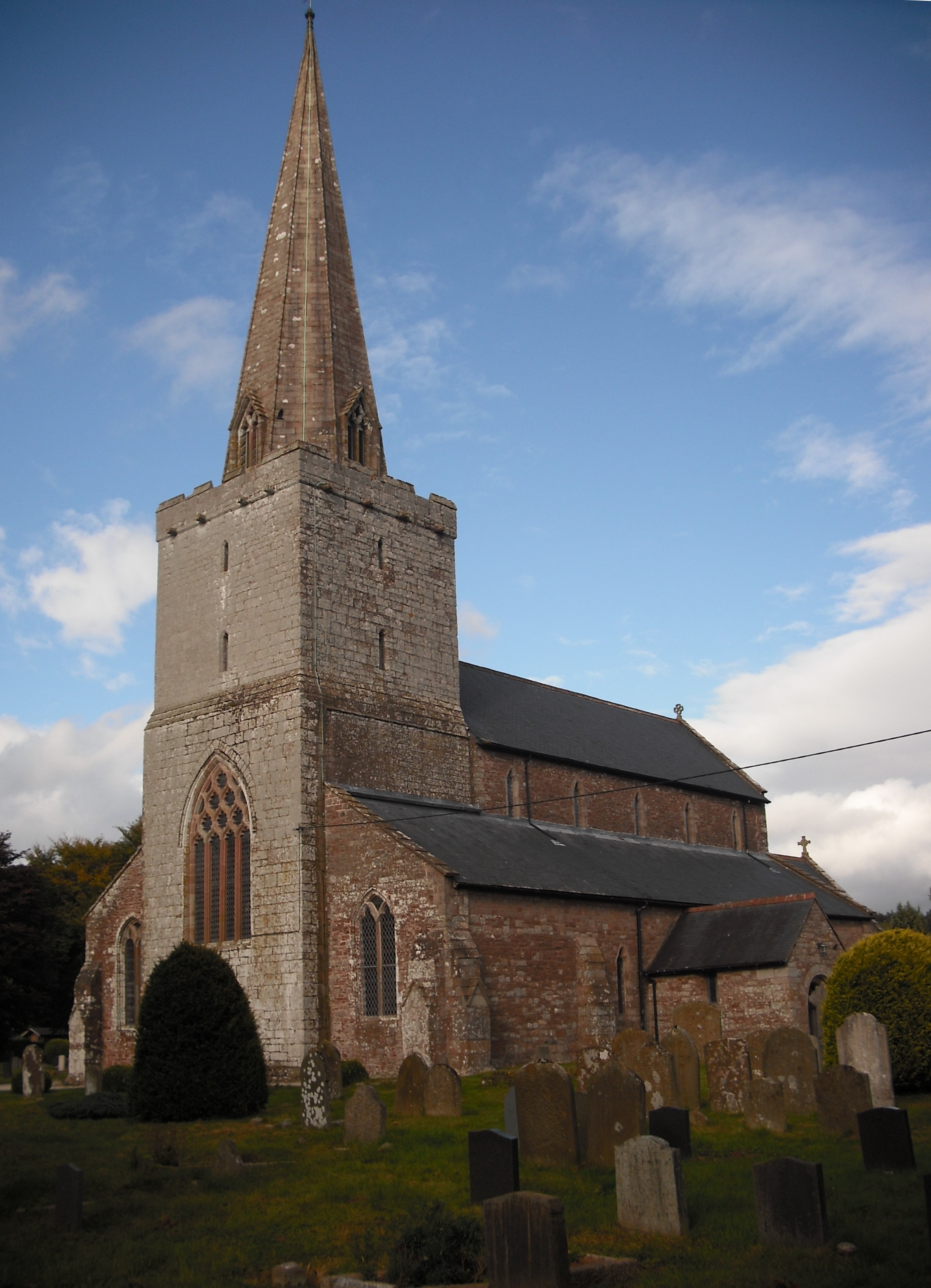
St Catwg's Church, Cwmcarvan

The Church of St Catwg in Cwmcarvan, Monmouthshire, Wales, is a parish church dating from the late 13th or early 14th century. It is dedicated to Saint...

Cwmcarvan

Cwmcarvan (Welsh: Cwmcarfan) is a small rural village in Monmouthshire, south east Wales. It is located 4 miles south west of Monmouth and about 4 miles...

Maes-yr-Uchaf Wood

Maes-yr-Uchaf Wood is a small woodland and Site of Special Scientific Interest (SSSI), noted for its biological characteristics, in Monmouthshire, south...

Croes Robert Wood

Croes Robert Wood is a nature reserve and Site of Special Scientific Interest (SSSI), noted for its biological characteristics, in Monmouthshire, south...

Lydart

Lydart is a dispersed hamlet within the community of Mitchel Troy, Monmouthshire, Wales. It is located about 3 miles (4.8 km) south-west of Monmouth,...

Church of St Nicholas, Trellech

The Church of St Nicholas, Trellech, Monmouthshire is a parish church with its origins in the 14th century. The historical and architectural evidence suggests...

Trellech

Trellech (occasionally spelt Trelech, Treleck or Trelleck; Welsh: Tryleg) is a village and parish in Monmouthshire, south-east Wales. Located 5 miles...

Nearby Amenities

Located within 500m of 51.764383,-2.74507
Direction: 175
Generator Method: photovoltaic
Generator Output Electricity: yes
Generator Solar Modules: 16
Generator Source: solar
Generator Type: solar_photovoltaic_panel
Location: roof
Power: generator
Lat/Long: 51.7685121/-2.7461033
The data included in this document is from www.openstreetmap.org. The data is made available under ODbL.

Have you been to Plantation Wood?

Leave your review of Plantation Wood below (or comments, questions and feedback).