Doley Wood

Wood, Forest in Flintshire

Wales

Doley Wood

Smokey Lane
Smokey Lane Credit: Oliver Dixon

Doley Wood is a beautiful woodland area located in Flintshire, Wales. Covering an area of approximately 50 acres, the wood is a mix of broadleaf and coniferous trees, creating a diverse and picturesque landscape. The wood is popular with both locals and visitors who come to enjoy its tranquil surroundings and natural beauty.

Doley Wood is home to a variety of wildlife, including birds, mammals, and insects. Visitors may spot deer, squirrels, and a wide range of bird species as they explore the wood. The woodland floor is covered in a carpet of bluebells in the spring, creating a stunning display of color.

There are several well-marked walking trails that wind through Doley Wood, allowing visitors to explore the wood at their own pace. The wood is also a popular destination for nature enthusiasts, birdwatchers, and photographers.

Overall, Doley Wood is a peaceful and enchanting woodland area that offers a welcome escape from the hustle and bustle of everyday life. Its natural beauty and diverse wildlife make it a must-visit destination for anyone looking to connect with nature in Flintshire.

If you have any feedback on the listing, please let us know in the comments section below.

Doley Wood Images

Images are sourced within 2km of 52.991927/-2.7830582 or Grid Reference SJ4744. Thanks to Geograph Open Source API. All images are credited.

Smokey Lane
Smokey Lane
We're in Wales here A reminder that we are in the Maelor Saesneg, an area of Wales which protrudes eastwards into English territory.
We're in Wales here
A reminder that we are in the Maelor Saesneg, an area of Wales which protrudes eastwards into English territory.
Two beauties at  Higher Lanes Bank Farm
Two beauties at Higher Lanes Bank Farm
Cattle at Higher Lanes Bank Farm
Tractor and Dutch barn Brine Pits Farm.
Tractor and Dutch barn
Brine Pits Farm.
Signpost with spring flowers At Drury Lane.
Signpost with spring flowers
At Drury Lane.
Tidy farmyard At Drury Farm.
Tidy farmyard
At Drury Farm.
Bank Farm, Oldcastle Former Cheshire farmhouse converted into a Claudian villa overlooking the beautiful Wych Brook valley. Photographed from public footpath Oldcastle 6, some 80m to the west on a misty autumn morning.
Bank Farm, Oldcastle
Former Cheshire farmhouse converted into a Claudian villa overlooking the beautiful Wych Brook valley. Photographed from public footpath Oldcastle 6, some 80m to the west on a misty autumn morning.
Wych Brook Valley View across the valley of Wych Brook on bearing of 255 deg from Wigland footpath 8, just south of its junction with footpath 5. The foreground is in England (and SJ 4943), beyond the valley is Wales (and SJ 4843) with Pen-y-Bryn Farm on the skyline. Wych Brook itself - invisible in its deep valley in midfield - only the tree tops showing - forms the border between Cheshire and Wales. This undulating terrain is mostly sheep farming country.
Wych Brook Valley
View across the valley of Wych Brook on bearing of 255 deg from Wigland footpath 8, just south of its junction with footpath 5. The foreground is in England (and SJ 4943), beyond the valley is Wales (and SJ 4843) with Pen-y-Bryn Farm on the skyline. Wych Brook itself - invisible in its deep valley in midfield - only the tree tops showing - forms the border between Cheshire and Wales. This undulating terrain is mostly sheep farming country.
Road towards Lower Wych
T-junction A T-junction of country lanes. A break in the hedgerow gives a view of Shropshire's agricultural land.
T-junction
A T-junction of country lanes. A break in the hedgerow gives a view of Shropshire's agricultural land.
Road, hedge and field A rather typical view of intensively-farmed land separated from the network of narrow roads by a hedge.
Road, hedge and field
A rather typical view of intensively-farmed land separated from the network of narrow roads by a hedge.
Attractive building next to fields Black-and-white-painted half-timbered upper storey (the woodwork of which appears to be too rectangular to be more than a decorative whim), a style which seems to be common in the area. This house lies next to the access road to Dymock's Mill.
Attractive building next to fields
Black-and-white-painted half-timbered upper storey (the woodwork of which appears to be too rectangular to be more than a decorative whim), a style which seems to be common in the area. This house lies next to the access road to Dymock's Mill.
Large Farmhouse, Oldcastle Heath
Field near Oldcastle Heath
Dymock's Mill, Tallarn Green
Show me another place!

Doley Wood is located at Grid Ref: SJ4744 (Lat: 52.991927, Lng: -2.7830582)

Unitary Authority: Wrexham

Police Authority: North Wales

What 3 Words

///familiar.skis.appoints. Near Malpas, Cheshire

Nearby Locations

Doley Wood

Related Wikis

Stockton, Cheshire

Stockton is a former civil parish, now in the parish of Malpas, in the Cheshire West and Chester district and ceremonial county of Cheshire in England...
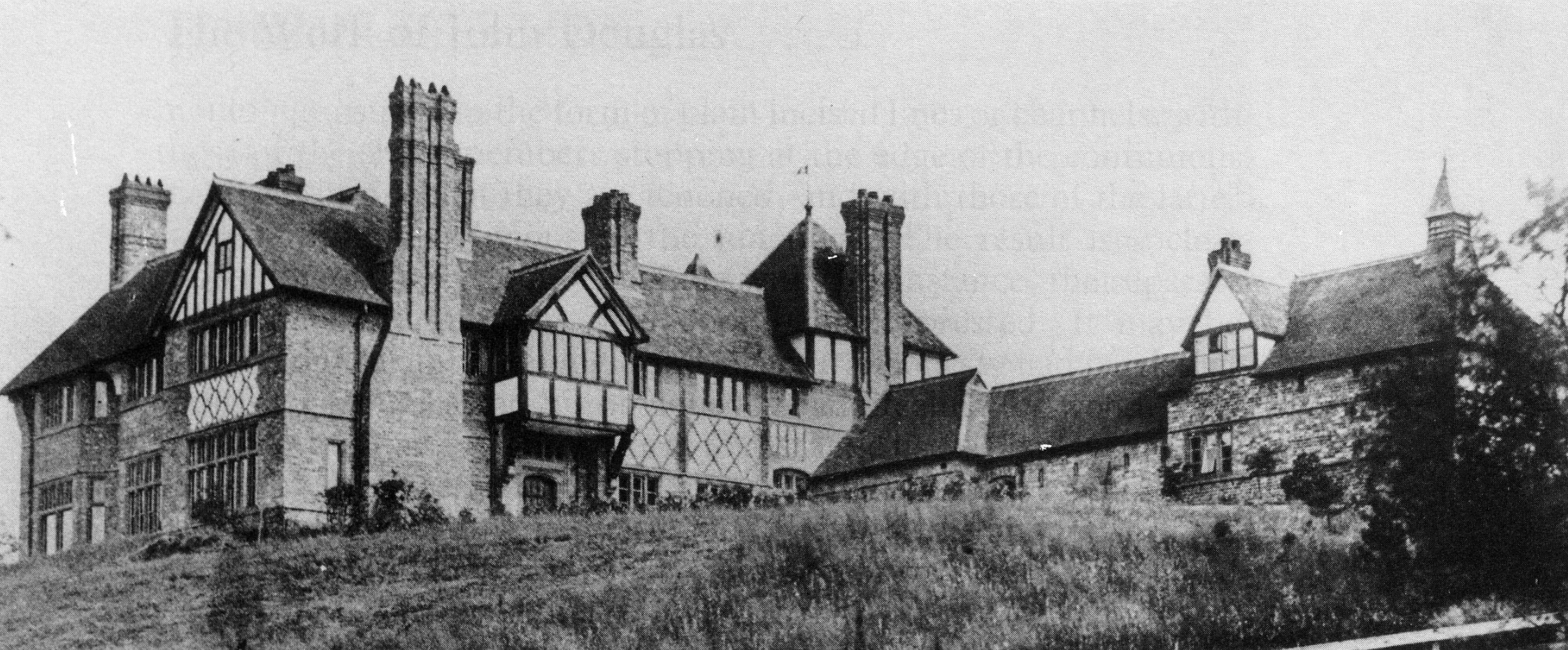
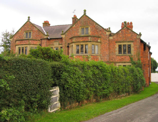
The Gelli

The Gelli is a small country house situated between Tallarn Green and Tybroughton in Wrexham County Borough, Wales. It is a Grade II* listed building...

Oldcastle, Cheshire

Oldcastle is a former civil parish, now in the parishes of Malpas and Threapwood, in the Cheshire West and Chester district and ceremonial county of Cheshire...

Lancaster Rural District

Lancaster Rural District was a rural district in the county of Lancashire, England. It was created in 1894 and abolished in 1974 under the Local Government...

Nearby Amenities

Located within 500m of 52.991927,-2.7830582
Direction: 235
Generator Method: photovoltaic
Generator Output Electricity: yes
Generator Solar Modules: 21
Generator Source: solar
Generator Type: solar_photovoltaic_panel
Location: roof
Power: generator
Lat/Long: 52.9900679/-2.7835673
The data included in this document is from www.openstreetmap.org. The data is made available under ODbL.

Have you been to Doley Wood?

Leave your review of Doley Wood below (or comments, questions and feedback).