Coed Pen-y-clawdd
Wood, Forest in Monmouthshire
Wales
Coed Pen-y-clawdd

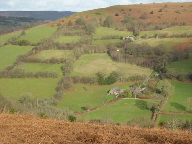
Coed Pen-y-clawdd is a picturesque woodland located in Monmouthshire, Wales. Covering an area of approximately 380 hectares, it is a beautiful natural haven that attracts visitors throughout the year. The woodland is situated near the village of Pen-y-clawdd, which is nestled between the towns of Usk and Raglan.
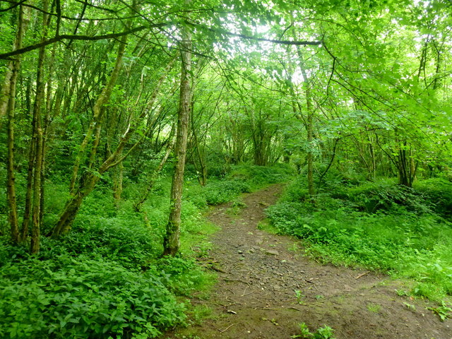
The woodland is predominantly composed of broadleaf trees, including oak, beech, ash, and birch. These trees create a dense canopy, providing shade and shelter for a diverse range of flora and fauna. Within the woodland, visitors can find a variety of wildflowers, ferns, and mosses, adding to its natural beauty.
Coed Pen-y-clawdd offers an extensive network of walking trails, allowing visitors to explore the woodland at their own pace. The trails range in difficulty, catering to both casual walkers and more experienced hikers. Along the way, visitors can enjoy stunning views of the surrounding countryside and may even spot some of the woodland's resident wildlife, such as deer, badgers, and various bird species.
The woodland also has a rich history, with evidence of human habitation dating back to the Iron Age. Remnants of ancient settlements, including hillforts and burial mounds, can still be seen within the woodland, providing a glimpse into the area's past.
Overall, Coed Pen-y-clawdd is an enchanting woodland that offers a tranquil escape from the hustle and bustle of everyday life. Its natural beauty, diverse wildlife, and historical significance make it a must-visit destination for nature enthusiasts and history buffs alike.
If you have any feedback on the listing, please let us know in the comments section below.
Coed Pen-y-clawdd Images
Images are sourced within 2km of 51.877592/-3.0057956 or Grid Reference SO3020. Thanks to Geograph Open Source API. All images are credited.


![Walkers' car park From here, a footpath leads up to the Sugar Loaf. On the slopes just beyond the gate is a good crop of bilberries, in season.[Looking SW]](https://s2.geograph.org.uk/photos/12/92/129246_57411172.jpg)


Coed Pen-y-clawdd is located at Grid Ref: SO3020 (Lat: 51.877592, Lng: -3.0057956)
Unitary Authority: Monmouthshire
Police Authority: Gwent
What 3 Words
///firmly.tight.rant. Near Abergavenny, Monmouthshire
Nearby Locations
Related Wikis

Pen y Clawdd Castle
Pen y Clawdd Castle is a ditched mound with a double moat, roughly circular in shape, with a diameter of approximately 28m to 30m and about 2.4m high....

Pen-y-Clawdd Court
Pen-y-Clawdd Court is a Grade I listed country house in Llanvihangel Crucorney, Monmouthshire, Wales, situated 1 mile (1.6 km) to the southwest of the...

Blaengavenny Farmhouse, Llanvihangel Crucorney
Blaengavenny Farmhouse, Llanvihangel Crucorney, Monmouthshire is a farmhouse of late medieval origins. It is a Grade II listed building. Its adjacent barn...
Llanvihangel railway station
Llanvihangel railway station was a former station which served the Monmouthshire village of Llanvihangel Crucorney. It was located on the Welsh Marches...

Bryn Arw
Bryn Arw is a hill in the Black Mountains of the Brecon Beacons National Park in Monmouthshire, south Wales. It lies 4 km north of the town of Abergavenny...

Llwyn-celyn Farmhouse, Llanvihangel Crucorney
Llwyn-celyn Farmhouse, Llanvihangel Crucorney, Monmouthshire is a farmhouse of late medieval origins. It is a Grade I listed building. == History == The...
St Michael's Church, Llanvihangel Crucorney
St Michael's Church stands in the centre of the village of Llanvihangel Crucorney, Monmouthshire, Wales. It was designated as a Grade II listed building...
Llanvihangel Crucorney
Llanvihangel Crucorney (Welsh: Llanfihangel Crucornau) is a small village in the community (parish) of Crucorney, Monmouthshire, Wales. It is located...
Nearby Amenities
Located within 500m of 51.877592,-3.0057956Have you been to Coed Pen-y-clawdd?
Leave your review of Coed Pen-y-clawdd below (or comments, questions and feedback).