Coed Llwyn-du

Wood, Forest in Monmouthshire

Wales

Coed Llwyn-du
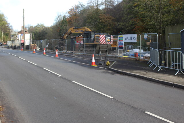
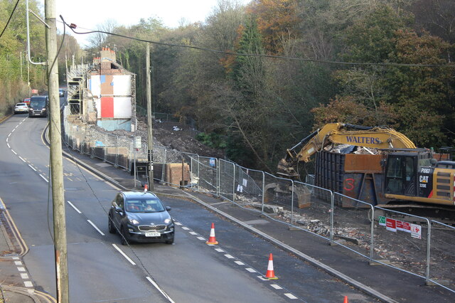
Demolition site, Hafod-yr-Ynys Road A row of houses has begun to be demolished because of the high concentration of nitrogen dioxide in the air. The remaining houses on Woodside Terrace, all purchased by Caerphilly Council, will all be demolished
Demolition site, Hafod-yr-Ynys Road Credit: M J Roscoe

Coed Llwyn-du, located in Monmouthshire, is a picturesque woodland area encompassing a vibrant and diverse ecosystem. Spanning approximately 200 acres, this ancient forest is nestled within the scenic landscape of the Welsh countryside.

The woodland is characterized by an abundance of native tree species, including oak, beech, ash, and birch. These trees form a dense canopy that provides shelter and habitat for numerous wildlife species. The forest floor is carpeted with a variety of plants, such as bluebells, ferns, and mosses, adding to the overall beauty and biodiversity of the area.

Coed Llwyn-du is home to a wide range of animal species. Visitors may spot red foxes, badgers, and rabbits, as well as a plethora of birdlife, including woodpeckers, owls, and various songbirds. The forest also supports a rich insect population, with butterflies, beetles, and bees being commonly seen.

The woodland offers a tranquil environment for nature enthusiasts, hikers, and photographers. It features a network of well-maintained footpaths, allowing visitors to explore the forest at their leisure. These paths wind through the ancient trees, offering stunning views and opportunities to observe the local wildlife.

In addition to its natural beauty, Coed Llwyn-du has historical significance. It is believed to have been in existence for centuries, and remnants of ancient structures, such as stone walls and old mining works, can still be found within the forest. These remnants provide a glimpse into the area's past and add an element of intrigue to the overall experience.

Overall, Coed Llwyn-du in Monmouthshire is a captivating woodland that offers visitors a chance to immerse themselves in the wonders of nature, explore its rich biodiversity, and discover its fascinating history.

If you have any feedback on the listing, please let us know in the comments section below.

Coed Llwyn-du Images

Images are sourced within 2km of 51.680636/-3.1219962 or Grid Reference ST2298. Thanks to Geograph Open Source API. All images are credited.

Demolition site, Hafod-yr-Ynys Road A row of houses has begun to be demolished because of the high concentration of nitrogen dioxide in the air. The remaining houses on Woodside Terrace, all purchased by Caerphilly Council, will all be demolished
Demolition site, Hafod-yr-Ynys Road
A row of houses has begun to be demolished because of the high concentration of nitrogen dioxide in the air. The remaining houses on Woodside Terrace, all purchased by Caerphilly Council, will all be demolished
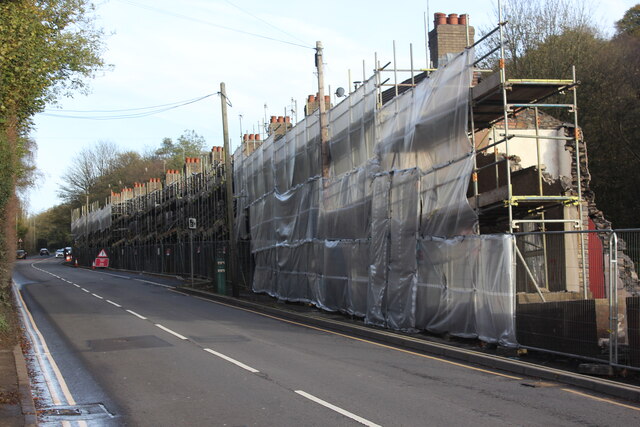
Houses ready for demolition, Hafod-yr-Ynys Road Row of terraced houses due to be demolished because of the high concentration of nitrogen dioxide in the air in the 'street canyon' in the valley. The green cabinet next to the telegraph pole houses the monitor of air pollutants.
Houses ready for demolition, Hafod-yr-Ynys Road
Row of terraced houses due to be demolished because of the high concentration of nitrogen dioxide in the air in the 'street canyon' in the valley. The green cabinet next to the telegraph pole houses the monitor of air pollutants.
House demolition site, Hafod-yr-Ynys Road All the houses on Woodside Terrace, purchased by Caerphilly Council, will be demolished because of severe air pollution on this busy cross-valley A road.
House demolition site, Hafod-yr-Ynys Road
All the houses on Woodside Terrace, purchased by Caerphilly Council, will be demolished because of severe air pollution on this busy cross-valley A road.
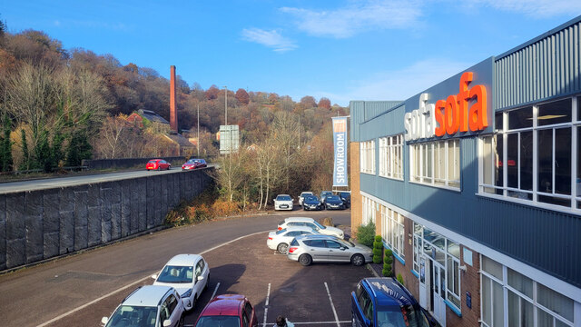
Sofa Sofa Looking towards the A467 at Crumlin from the furniture retailer's showroom.
Sofa Sofa
Looking towards the A467 at Crumlin from the furniture retailer's showroom.
Hafodyrynys Coal Washery The washery at Hafodyrynys contained equipment for extracting coal dust from slurry and drying the remaining waste before tipping: processes which were rare before the 1950s. It was built entirely of reinforced concrete with continuous glazed panels. The colliery closed in 1966 and the site was cleared in 1985, but the slimes thickener at the washery was retained at the request of Sir Richard Hanbury-Tenison of Pontypool Park Estate, to which the site reverted. Plans were drawn up at the time to adapt the building as a restaurant. Its futuristic use of reinforced concrete and the splendid isolation in which it now stands have made it a well-known landmark.
Hafodyrynys Coal Washery
The washery at Hafodyrynys contained equipment for extracting coal dust from slurry and drying the remaining waste before tipping: processes which were rare before the 1950s. It was built entirely of reinforced concrete with continuous glazed panels. The colliery closed in 1966 and the site was cleared in 1985, but the slimes thickener at the washery was retained at the request of Sir Richard Hanbury-Tenison of Pontypool Park Estate, to which the site reverted. Plans were drawn up at the time to adapt the building as a restaurant. Its futuristic use of reinforced concrete and the splendid isolation in which it now stands have made it a well-known landmark.
Ordnance Survey Cut Mark This OS cut mark can be found on the old Pithead Baths. It marks a point 164.741m above mean sea level.
Ordnance Survey Cut Mark
This OS cut mark can be found on the old Pithead Baths. It marks a point 164.741m above mean sea level.
Path up from Llanhilleth Colliery Memorial Path on the edge of Granny's Wood from memorial <a href="https://www.geograph.org.uk/photo/7241714">SO2200 : Llanhilleth Colliery Memorial, Granny's Wood</a> to derelict pithead baths.
Path up from Llanhilleth Colliery Memorial
Path on the edge of Granny's Wood from memorial SO2200 : Llanhilleth Colliery Memorial, Granny's Wood to derelict pithead baths.
Path under road to Llanhilleth Colliery Memorial The path goes down from the derelict pithead baths under the High Street, B4471, at Horseshoe Bend into Granny's Wood and to the memorial <a href="https://www.geograph.org.uk/photo/7241714">SO2200 : Llanhilleth Colliery Memorial, Granny's Wood</a>.
Path under road to Llanhilleth Colliery Memorial
The path goes down from the derelict pithead baths under the High Street, B4471, at Horseshoe Bend into Granny's Wood and to the memorial SO2200 : Llanhilleth Colliery Memorial, Granny's Wood.
Path up to derelict pithead baths The path, the continuation of <a href="https://www.geograph.org.uk/photo/724165">SE1322 : Bridge at Cromwell Lock, Southowram</a>, goes from Granny's Wood under the High Street bridge <a href="https://www.geograph.org.uk/photo/7241678">SO2200 : Path under road to Llanhilleth Colliery Memorial</a>.
Path up to derelict pithead baths
The path, the continuation of SE1322 : Bridge at Cromwell Lock, Southowram, goes from Granny's Wood under the High Street bridge SO2200 : Path under road to Llanhilleth Colliery Memorial.
Llanhilleth Colliery Memorial, Granny's Wood The colliery, opened in 1892, closed in 1969 and the area between the High Street and the railway has reverted largely to woodland.
Llanhilleth Colliery Memorial, Granny's Wood
The colliery, opened in 1892, closed in 1969 and the area between the High Street and the railway has reverted largely to woodland.
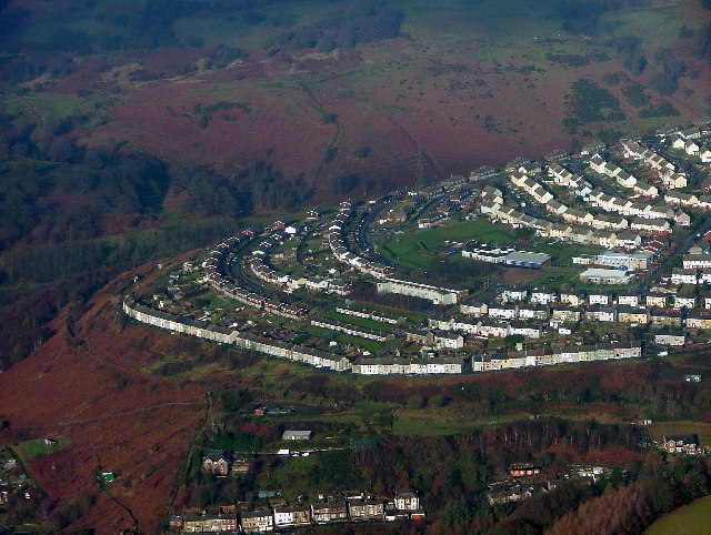
Swffryd Swffryd from the air (this is the site of the original Crumlin viaduct, made famous by the film 'Arabesque' starring Gregory Peck and Sopia Loren). Thanks to Mike Hale for the info.
Swffryd
Swffryd from the air (this is the site of the original Crumlin viaduct, made famous by the film 'Arabesque' starring Gregory Peck and Sopia Loren). Thanks to Mike Hale for the info.
Crumlin, Caerphilly Disused Crumlin Navigation Colliery from Trinant Hall
Crumlin, Caerphilly
Disused Crumlin Navigation Colliery from Trinant Hall
Glyn Tunnel Eastern portal of the 280yd, single track Glyn tunnel on the former GW line between Hafodyrynys and Crumlin Jcn, photographed in 1980.  When the photo was taken the western portal had already been buried.  Subsequently, this end has also been infilled and buried beneath a whole lot of landscaping - which might excuse the poor quality of the photo, taken in early evening and a lot of Welsh weather!
Glyn Tunnel
Eastern portal of the 280yd, single track Glyn tunnel on the former GW line between Hafodyrynys and Crumlin Jcn, photographed in 1980. When the photo was taken the western portal had already been buried. Subsequently, this end has also been infilled and buried beneath a whole lot of landscaping - which might excuse the poor quality of the photo, taken in early evening and a lot of Welsh weather!
Power Lines
Power Lines
Road to Pen-y-caeau
Road to Pen-y-caeau
Bog grasses, near Ysgubor Wen
Lone sheep
Lone sheep
Hafodyrynys: snow on the A472 Just east of Hafodyrynys, the snow has settled upon this stile rather strikingly.
Hafodyrynys: snow on the A472
Just east of Hafodyrynys, the snow has settled upon this stile rather strikingly.
Show me another place!

Coed Llwyn-du is located at Grid Ref: ST2298 (Lat: 51.680636, Lng: -3.1219962)

Unitary Authority: Caerphilly

Police Authority: Gwent

What 3 Words

///wasps.reverses.clutches. Near Crumlin, Caerphilly

Nearby Locations

Coed Llwyn-du

Related Wikis

Hafodyrynys Platform railway station

Hafodyrynys Platform railway station was a station on the former Taff Vale Extension of the Newport, Abergavenny and Hereford Railway. It served the village...

Hafodyrynys

Hafodyrynys is a village on the A472 road between Pontypool and Crumlin in Caerphilly county borough, south-east Wales. It lies within the historic boundaries...

Swffryd

Swffryd (or Sofrydd) is a Welsh community on the boundary of Blaenau Gwent County Borough Council. == Geography == The Ebbw River flows past the west...

Crumlin, Caerphilly

Crumlin (Welsh: Crymlyn) is a town, community and electoral ward in Caerphilly county borough in South Wales. It is situated in the Ebbw River valley,...

Crumlin Arm (Monmouthshire canal)

The Crumlin Arm of the Monmouthshire canal is part of the Monmouthshire & Brecon Canal network in South Wales. It connected Crumlin and its tramways to...

Crumlin Viaduct

The Crumlin Viaduct was a railway viaduct located above the village of Crumlin in South Wales, originally built to carry the Taff Vale Extension of the...

Ebbw Valley Railway

The Ebbw Valley Railway (Welsh: Rheilffordd Cwm Ebwy) is a branch line of the South Wales Main Line in South Wales. Transport for Wales Rail provides an...

Newbridge, Caerphilly

Newbridge (Welsh: Trecelyn) is a town and community in the county borough of Caerphilly, south Wales. It lies within the historic boundaries of the county...

Nearby Amenities

Located within 500m of 51.680636,-3.1219962
Hafodyrynys Platform
Historic Railway: station
Railway: site
Wikidata: Q30623246
Wikipedia: en:Hafodyrynys Platform railway station
Lat/Long: 51.6816598/-3.1268164
Crossing
Crossing: traffic_signals
Crossing Ref: pelican
Lat/Long: 51.6833556/-3.1192944
Power: tower
Lat/Long: 51.6797703/-3.1193185
Power: tower
Lat/Long: 51.6825355/-3.1275791
Power: tower
Lat/Long: 51.6788624/-3.1166698
Power: tower
Lat/Long: 51.6805184/-3.1214363
Fast Food
Happy Garden Fish Bar
Addr City: Hafodyrynys
Addr Postcode: NP11 5BD
Addr Street: Cefn Crib Road
Cuisine: fish_and_chips
Opening Hours: Mo 17:30-22:00; Tu off; We-Sa 17:30-23:00; Su 10:00-16:00,18:30-22:00
Opening Hours Covid19: Mo 17:30-22:00; Tu Off; We-Sa 17:30-23:00; Su 10:00-16:00,18:30-22:00
Phone: +44 1495 249 202
Website: https://en-gb.facebook.com/HappyGardenChineseTakeaway
Lat/Long: 51.6839512/-3.1185186
Pub
Hafodyrynys Inn
Addr City: Hafodyrynys
Addr Postcode: NP11 5BE
Addr Street: A472
Email: hafodinn1996@gmail.com
Opening Hours: Mo off; Tu-Sa 12:00-21:00; Su 12:30-14:30
Opening Hours Covid19: Mo Off; Tu-Sa 12:00-21:00; Su 12:30-14:30
Phone: +44 1495 243 010
Website: https://en-gb.facebook.com/hafodyrynys.inn
Wikidata: Q80583048
Lat/Long: 51.6838348/-3.1188835
Post Box
Operator: Royal Mail
Post Box Type: lamp
Lat/Long: 51.6838481/-3.1183375
Hafodyrynys
Place: village
Wikidata: Q5638416
Wikipedia: en:Hafodyrynys
Lat/Long: 51.6841781/-3.119475
Direction: 170
Generator Method: photovoltaic
Generator Output Electricity: yes
Generator Solar Modules: 10
Generator Source: solar
Generator Type: solar_photovoltaic_panel
Location: roof
Power: generator
Lat/Long: 51.6827664/-3.1270983
Direction: 260
Generator Method: photovoltaic
Generator Output Electricity: yes
Generator Solar Modules: 6
Generator Source: solar
Generator Type: solar_photovoltaic_panel
Location: roof
Power: generator
Lat/Long: 51.6828171/-3.1271439
Direction: 165
Generator Method: photovoltaic
Generator Output Electricity: yes
Generator Solar Modules: 10
Generator Source: solar
Generator Type: solar_photovoltaic_panel
Location: roof
Power: generator
Lat/Long: 51.6825065/-3.1284555
Bus Stop
Bench: yes
Bus: yes
Departures Board: timetable
Level: 0
Lit: yes
Naptan AtcoCode: 5540AWB32623
Naptan NaptanCode: cpydagj
Network: Stagecoach South Wales
Operator: Stagecoach South Wales
Public Transport: platform
Shelter: yes
Lat/Long: 51.68381/-3.1184672
Bus Stop
Bench: yes
Bus: yes
Departures Board: timetable
Level: 0
Lit: yes
Naptan AtcoCode: 5540AWB32622
Naptan NaptanCode: cpydagd
Network: Stagecoach South Wales
Operator: Stagecoach South Wales
Public Transport: platform
Shelter: yes
Lat/Long: 51.6835813/-3.1185174
Give Way
Direction: backward
Lat/Long: 51.6830378/-3.1233008
Traffic Calming: choker
Lat/Long: 51.6830758/-3.1235239
The data included in this document is from www.openstreetmap.org. The data is made available under ODbL.

Have you been to Coed Llwyn-du?

Leave your review of Coed Llwyn-du below (or comments, questions and feedback).