Coed Cochion

Wood, Forest in Montgomeryshire

Wales

Coed Cochion

Ordnance Survey Cut Mark This OS cut mark can be found on the wall SW side of the road. It marks a point 123.597m above mean sea level.
Ordnance Survey Cut Mark Credit: Adrian Dust

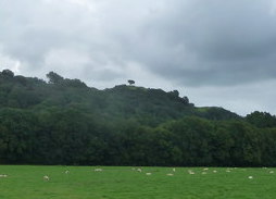
Coed Cochion is a picturesque woodland located in the county of Montgomeryshire, Wales. Spanning over a vast area, this woodland is renowned for its natural beauty and rich biodiversity. The name "Coed Cochion" translates to "Red Forest" in English, a nod to the vibrant hues of the trees that dominate the landscape during autumn.

Situated amidst the rolling hills and valleys, Coed Cochion offers a tranquil retreat for nature enthusiasts and hikers alike. The woodland is composed of a variety of tree species, including oak, beech, and birch, creating a diverse and thriving ecosystem. The forest floor is adorned with a carpet of wildflowers, adding bursts of color to the already enchanting scenery.

The woodland is crisscrossed by a network of well-maintained walking trails, allowing visitors to explore the area and discover its hidden gems. As one ventures deeper into Coed Cochion, they may stumble upon a babbling brook or a secluded pond, home to an array of aquatic life.

Coed Cochion is not only a haven for flora and fauna but also a sanctuary for a range of bird species. Ornithologists flock to the area to catch a glimpse of rare and migratory birds, including the elusive red kite and the vibrant kingfisher.

Overall, Coed Cochion offers a captivating escape from the hustle and bustle of daily life. Its natural beauty and diverse ecosystem make it a must-visit destination for those seeking to immerse themselves in the wonders of nature.

If you have any feedback on the listing, please let us know in the comments section below.

Coed Cochion Images

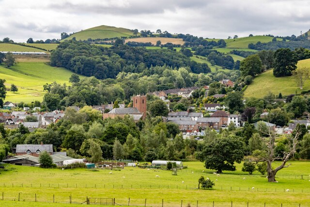
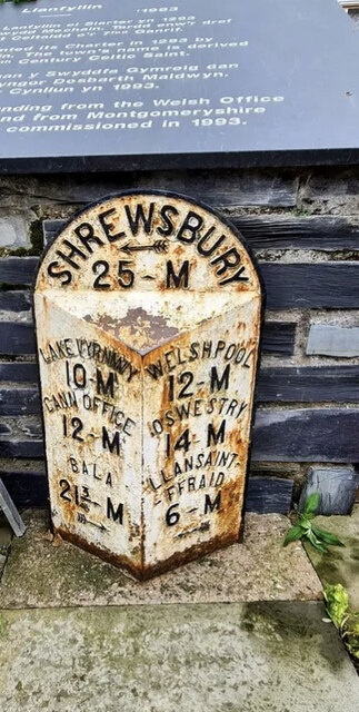
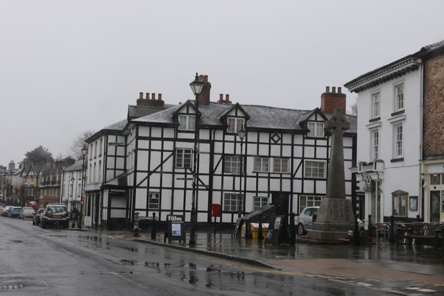
Images are sourced within 2km of 52.773701/-3.2528243 or Grid Reference SJ1520. Thanks to Geograph Open Source API. All images are credited.

Ordnance Survey Cut Mark This OS cut mark can be found on the wall SW side of the road. It marks a point 123.597m above mean sea level.
Ordnance Survey Cut Mark
This OS cut mark can be found on the wall SW side of the road. It marks a point 123.597m above mean sea level.
Ordnance Survey Cut Mark This OS cut mark can be found on the NW parapet of the bridge. It marks a point 123.312m above mean sea level.
Ordnance Survey Cut Mark
This OS cut mark can be found on the NW parapet of the bridge. It marks a point 123.312m above mean sea level.
St. Myllin's church, Llanfyllin
Former Agricultural Worker's Cottages, Llanfyllin
Llanfyllin View over Llanfyllin.
Llanfyllin
View over Llanfyllin.
East Lodge The East Lodge to Bodfach Hall.
East Lodge
The East Lodge to Bodfach Hall.
Chapel Chapel in Llanfyllin.
Chapel
Chapel in Llanfyllin.
Old Milestone by the A490, High Street, Llanfyllin By the A490, in parish of Llanfyllin (Powys District), Market Square, Llanfyllin, in front of commemorative stone and memorial.

Inscription reads:- : LAKE VYRNWY / 10-M / CANN OFFICE / 12-M / BALA / 21¾-M {arrow} : : SHREWSBURY / {arrow} / 25-M : : WELSHPOOL / 12-M / OSWESTRY / 14-M / LLANSAINT- / -FFRAID / 6-M / {arrow} : 

Milestone Society National ID: MOT_LFSA00
Old Milestone by the A490, High Street, Llanfyllin
By the A490, in parish of Llanfyllin (Powys District), Market Square, Llanfyllin, in front of commemorative stone and memorial. Inscription reads:- : LAKE VYRNWY / 10-M / CANN OFFICE / 12-M / BALA / 21¾-M {arrow} : : SHREWSBURY / {arrow} / 25-M : : WELSHPOOL / 12-M / OSWESTRY / 14-M / LLANSAINT- / -FFRAID / 6-M / {arrow} : Milestone Society National ID: MOT_LFSA00
Mid Wales WWII defences: bridge at Llanfyllin - spigot mortar pedestal -
Spigot Mortar Emplacement: DoB ID: e40364

Still guarding the bridge at Llanfyllin, the spigot mortar or "Blacker Bombard" was essentially an anti-tank weapon used almost exclusively by the Home Guard during the Second World War. They were located at strategic locations alongside other defences throughout the country in response to the German invasion threat of 1940.
Mid Wales WWII defences: bridge at Llanfyllin - spigot mortar pedestal
- Spigot Mortar Emplacement: DoB ID: e40364 Still guarding the bridge at Llanfyllin, the spigot mortar or "Blacker Bombard" was essentially an anti-tank weapon used almost exclusively by the Home Guard during the Second World War. They were located at strategic locations alongside other defences throughout the country in response to the German invasion threat of 1940.
Entering Llanfyllin On the A490 heading south east
Entering Llanfyllin
On the A490 heading south east
No. 1 Market Street, Llanfyllin Grade II listed building (8613) on the corner of High Street and Market Street, Llanfyllin. 

Probably early C19 rebuilding of earlier (C16/C17) buildings on site. Formerly 'The Upper Boar In The Net' Inn, and subsequently from circa 1901, 'Llanfyllin Temperance Hotel'. Mock half-timbering added circa 1900 when windows and doors were re-ordered; dormers added circa 1920s.
No. 1 Market Street, Llanfyllin
Grade II listed building (8613) on the corner of High Street and Market Street, Llanfyllin. Probably early C19 rebuilding of earlier (C16/C17) buildings on site. Formerly 'The Upper Boar In The Net' Inn, and subsequently from circa 1901, 'Llanfyllin Temperance Hotel'. Mock half-timbering added circa 1900 when windows and doors were re-ordered; dormers added circa 1920s.
Market Street, Llanfyllin The centre of Llanfyllin seen from an upstairs window in the Cain Valley Hotel. The building on the immediate left was once the Temperance Hotel and on the right the Town Hall.
Market Street, Llanfyllin
The centre of Llanfyllin seen from an upstairs window in the Cain Valley Hotel. The building on the immediate left was once the Temperance Hotel and on the right the Town Hall.
Market Street, Llanfyllin In Victorian times Market Street was filled with shops but nowadays it is mainly residential. Even the old Moreia Chapel on the right is currently for sale with planning permission for conversion into three flats.
Market Street, Llanfyllin
In Victorian times Market Street was filled with shops but nowadays it is mainly residential. Even the old Moreia Chapel on the right is currently for sale with planning permission for conversion into three flats.
Narrow Street, Llanfyllin The name seems entirely appropriate; the street is indeed narrow. 'Down to Earth' on the left sells fruit and vegetables.
Narrow Street, Llanfyllin
The name seems entirely appropriate; the street is indeed narrow. 'Down to Earth' on the left sells fruit and vegetables.
Former Post Office, Llanfyllin These premises ceased to operate as a post office in 2015 when the service was moved into the nearby Spar convenience store. This meant longer opening hours but something of the old style was inevitably lost.
Former Post Office, Llanfyllin
These premises ceased to operate as a post office in 2015 when the service was moved into the nearby Spar convenience store. This meant longer opening hours but something of the old style was inevitably lost.
Llanfyllin Church St Myllin's Church is a rare example of a church built during the reign of Queen Anne outside London and it has many features characteristic of that period. This shows some of the detail from the churchyard.
Llanfyllin Church
St Myllin's Church is a rare example of a church built during the reign of Queen Anne outside London and it has many features characteristic of that period. This shows some of the detail from the churchyard.
Llanfyllin Church The church is dedicated to St Myllin who is believed to have been a 7th century Irish monk and Bishop of Ferns. By the early 18th century the existing medieval church had become too small for the growing town and was replaced by the current building - a rare example of a church built in the reign of Queen Anne outside London. By Victorian times, however, the architecture had become unfashionable and the 'Norman' arches seen here were inserted in an effort to give the interior a more traditional feel.
Llanfyllin Church
The church is dedicated to St Myllin who is believed to have been a 7th century Irish monk and Bishop of Ferns. By the early 18th century the existing medieval church had become too small for the growing town and was replaced by the current building - a rare example of a church built in the reign of Queen Anne outside London. By Victorian times, however, the architecture had become unfashionable and the 'Norman' arches seen here were inserted in an effort to give the interior a more traditional feel.
Benefaction Board - Llanfyllin Church This 'benefaction board' inside the church shows how money was raised in the reign of Queen Anne to build the current church, the total cost of which was about £1225.
Benefaction Board - Llanfyllin Church
This 'benefaction board' inside the church shows how money was raised in the reign of Queen Anne to build the current church, the total cost of which was about £1225.
Show me another place!

Coed Cochion is located at Grid Ref: SJ1520 (Lat: 52.773701, Lng: -3.2528243)

Unitary Authority: Powys

Police Authority: Dyfed Powys

What 3 Words

///task.hotel.blacken. Near Llanfyllin, Powys

Related Wikis

Lonely Tree

The Lonely Tree was a Scots pine on a hill near Llanfyllin, Powys, Wales. Visible from much of the town it was a local landmark with several traditions...

Llanfyllin railway station

Llanfyllin railway station is the former terminal station of the Llanfyllin Branch of Cambrian Railways, which served the town of Llanfyllin in Powys,...

Llanfyllin

Llanfyllin (Welsh pronunciation: [ɬanˈvəɬɪn] – ) is a market town and community in Powys, Wales. The town population in 2021 was 1,586 and the town's...

Llanfyllin High School

Llanfyllin High School (Welsh: Ysgol Uwchradd Llanfyllin) was a bilingual secondary school situated in the mid-Wales town of Llanfyllin. As of its final...

Nearby Amenities

Located within 500m of 52.773701,-3.2528243
Grave Hill
Ele: 284
Natural: peak
Lat/Long: 52.7752978/-3.2523544
The data included in this document is from www.openstreetmap.org. The data is made available under ODbL.

Have you been to Coed Cochion?

Leave your review of Coed Cochion below (or comments, questions and feedback).