Coed Caeau-gwynedd

Wood, Forest in Montgomeryshire

Wales

Coed Caeau-gwynedd

Ordnance Survey Rivet This OS rivet can be found on the cattle grid north side of the road. It marks a point 328.116m above mean sea level.
Ordnance Survey Rivet Credit: Adrian Dust

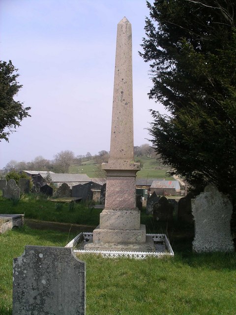
Coed Caeau-gwynedd is a picturesque woodland located in Montgomeryshire, Wales. Spanning over a vast area, this forest is renowned for its stunning natural beauty and rich biodiversity. The name "Caeau-gwynedd" translates to "white field" in Welsh, which is reflective of the open meadows that surround the woodland.

The forest is characterized by its diverse range of tree species, including oak, beech, birch, and pine. These towering trees create a dense canopy, providing shade and shelter for a variety of wildlife. Visitors to Coed Caeau-gwynedd can expect to encounter a plethora of bird species, such as woodpeckers, owls, and various songbirds, filling the air with their melodic tunes.

The woodland is also home to a wide array of mammals, including badgers, foxes, and deer. Exploring the forest, one may come across their tracks or even catch a glimpse of these elusive creatures. Additionally, Coed Caeau-gwynedd boasts a vibrant ecosystem of insects and smaller critters, contributing to the overall ecological balance of the area.

The forest offers an array of recreational activities for nature enthusiasts. Visitors can enjoy hiking along the numerous trails that wind through the woodland, offering breathtaking views of the surrounding countryside. The forest also features picnic areas and camping spots, allowing visitors to immerse themselves in the tranquility of nature.

Coed Caeau-gwynedd is not only a haven of natural beauty but also an important habitat for many species. Its preservation and conservation efforts ensure that future generations can continue to enjoy and appreciate the wonders of this enchanting woodland.

If you have any feedback on the listing, please let us know in the comments section below.

Coed Caeau-gwynedd Images

Images are sourced within 2km of 52.757384/-3.3142526 or Grid Reference SJ1118. Thanks to Geograph Open Source API. All images are credited.

Ordnance Survey Rivet This OS rivet can be found on the cattle grid north side of the road. It marks a point 328.116m above mean sea level.
Ordnance Survey Rivet
This OS rivet can be found on the cattle grid north side of the road. It marks a point 328.116m above mean sea level.
Sheep pens
Sheep pens
Trackway to Craignant-mawr An extremely peaceful area - a lot of our walked covered the endless lanes and we only saw one car all day - the postman.  Moel Llaethbwlch behind the photographer.
Trackway to Craignant-mawr
An extremely peaceful area - a lot of our walked covered the endless lanes and we only saw one car all day - the postman. Moel Llaethbwlch behind the photographer.
Moel Llaethbwlch When I first glanced at the map, without my reading glasses, I read it as Moel Llaethbuwch.  This as a name far more prosaic in that it would have meant Milky Cow Hill.  Milk Pass Hill a good second place.  This hill at 1,190ft stands proud of the many local bumps.  Strangely, there is a spot height of 348 metres slightly northwest and below the summit.
Moel Llaethbwlch
When I first glanced at the map, without my reading glasses, I read it as Moel Llaethbuwch. This as a name far more prosaic in that it would have meant Milky Cow Hill. Milk Pass Hill a good second place. This hill at 1,190ft stands proud of the many local bumps. Strangely, there is a spot height of 348 metres slightly northwest and below the summit.
Start of bridleway across ridge behind Moel Llaethbwlch The one and only footpath sign and stile we found on our entire walk.  And this gate when we tried to open it collapsed - the post had rotted through at the base.  This even though the whole gate and stile seemed fairly new.
Start of bridleway across ridge behind Moel Llaethbwlch
The one and only footpath sign and stile we found on our entire walk. And this gate when we tried to open it collapsed - the post had rotted through at the base. This even though the whole gate and stile seemed fairly new.
Transmitter station at Moel y Fronllwyd Couldn't gain much intelligence as to what this place was about from the signs thereon.  But it did make a great picnic stop.
Transmitter station at Moel y Fronllwyd
Couldn't gain much intelligence as to what this place was about from the signs thereon. But it did make a great picnic stop.
Curious cattle on the bridleway by Moel Llaethbwlch If anyone's walked this path this year I'd be surprised.  These youngsters were certainly interested in the first passers-by in a while.
Curious cattle on the bridleway by Moel Llaethbwlch
If anyone's walked this path this year I'd be surprised. These youngsters were certainly interested in the first passers-by in a while.
Old Milestone by the B4393, east of Pont Radin, Llanfyllin parish Turner Arrow Casting by the B4393, in parish of Llanfyllin (Powys District), East of Pont Radin, on verge, South side of road.

Inscription reads:-
: LLANFILLIN / 1-M / {<-arrow} : : CANN OFFICE / {arrow->} / 11-M } : : LAKE VYRNWY / 9-M / {arrow->} :

Surveyed

Milestone Society National ID: MOT_LFCO04
Old Milestone by the B4393, east of Pont Radin, Llanfyllin parish
Turner Arrow Casting by the B4393, in parish of Llanfyllin (Powys District), East of Pont Radin, on verge, South side of road. Inscription reads:- : LLANFILLIN / 1-M / {<-arrow} : : CANN OFFICE / {arrow->} / 11-M } : : LAKE VYRNWY / 9-M / {arrow->} : Surveyed Milestone Society National ID: MOT_LFCO04
Downhill near Coed Gardden Location from Where&amp;#039;s the path. Looking east along the lane which is wooded on the right side
Downhill near Coed Gardden
Location from Where's the path. Looking east along the lane which is wooded on the right side
Nant Allan looking west.
Methodist chapel and manse at Tycrwyn near Llanfyllin The redbrick Methodist chapel is dated 1891 and may well be a rebuild of an older one that was contemporaneous with the obviously older cottage manse, where I presume the minister lived. Lovely spot. How rural Wales, like everywhere else, has changed since 1891. Even 1991.
Methodist chapel and manse at Tycrwyn near Llanfyllin
The redbrick Methodist chapel is dated 1891 and may well be a rebuild of an older one that was contemporaneous with the obviously older cottage manse, where I presume the minister lived. Lovely spot. How rural Wales, like everywhere else, has changed since 1891. Even 1991.
Old cottage to the rear of Tycrwyn Methodist chapel Once maybe the manse. Looking a bit neglected. Not yet a conversion or &amp;#039;renno&amp;#039; thankfully.
Old cottage to the rear of Tycrwyn Methodist chapel
Once maybe the manse. Looking a bit neglected. Not yet a conversion or 'renno' thankfully.
Tycrwyn Methodist chapel The plaque reads 1891. As rural chapel-going populations age and pass on to glory, countless chapels like this one will fall out of use and face the likelihood of becoming converted into a home or business premises or slipping into disrepair, neglect and dilapidation.
Tycrwyn Methodist chapel
The plaque reads 1891. As rural chapel-going populations age and pass on to glory, countless chapels like this one will fall out of use and face the likelihood of becoming converted into a home or business premises or slipping into disrepair, neglect and dilapidation.
B4393 just south west of Cwm Alan Looking towards Vyrnwy. Muddy layby can be seen to the left
B4393 just south west of Cwm Alan
Looking towards Vyrnwy. Muddy layby can be seen to the left
B4393 approaching Tycrwyn from the east
Entrance to Llwynderw Y Foel from Foul Street On lane from Tycrwyn
Entrance to Llwynderw Y Foel from Foul Street
On lane from Tycrwyn
Entrance to Hafod from Cefn Brân
Entrance to Gwastad from Cefn Brân
Show me another place!

Coed Caeau-gwynedd is located at Grid Ref: SJ1118 (Lat: 52.757384, Lng: -3.3142526)

Unitary Authority: Powys

Police Authority: Dyfed Powys

What 3 Words

///hats.dares.shuttle. Near Llanfyllin, Powys

Nearby Locations

Coed Caeau-gwynedd

Related Wikis

Bodfach

Bodfach is a hamlet in the community of Llanfyllin, Powys, Wales, which is 89 miles (144 km) from Cardiff and 160 miles (257 km) from London.Nearby Bodfach...

Tomen yr Allt

Tomen yr Allt (or Domen yr Allt) was a Medieval motte and bailey defensive castle near Llanfyllin in Powys, Wales. "Tomen ar hallt" is modern Welsh for...

Llanfyllin High School

Llanfyllin High School (Welsh: Ysgol Uwchradd Llanfyllin) was a bilingual secondary school situated in the mid-Wales town of Llanfyllin. As of its final...

Llanfyllin

Llanfyllin (Welsh pronunciation: [ɬanˈvəɬɪn] – ) is a market town and community in Powys, Wales. The town population in 2021 was 1,586 and the town's...

Llanfyllin railway station

Llanfyllin railway station is the former terminal station of the Llanfyllin Branch of Cambrian Railways, which served the town of Llanfyllin in Powys,...

Plynlimon and Hafan Tramway

The Plynlimon and Hafan Tramway was a 2 ft 3 in (686 mm) gauge narrow gauge railway in Cardiganshire (now Ceredigion) in Mid Wales. It ran from Llanfihangel...

Llanfihangel-yng-Ngwynfa

Llanfihangel-yng-Ngwynfa () was a parish within the former historic county of Montgomeryshire. It now forms a major part of the community of Llanfihangel...
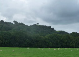
Lonely Tree

The Lonely Tree was a Scots pine on a hill near Llanfyllin, Powys, Wales. Visible from much of the town it was a local landmark with several traditions...

Nearby Amenities

Located within 500m of 52.757384,-3.3142526
Ford: yes
Lat/Long: 52.758571/-3.3200008
Man Made: utility_pole
Lat/Long: 52.7556286/-3.3101364
The data included in this document is from www.openstreetmap.org. The data is made available under ODbL.

Have you been to Coed Caeau-gwynedd?

Leave your review of Coed Caeau-gwynedd below (or comments, questions and feedback).