Coed Rhedyn-côch

Wood, Forest in Flintshire

Wales

Coed Rhedyn-côch

The village church at Cwm near Dyserth
The village church at Cwm near Dyserth Credit: Colin Park

Coed Rhedyn-côch, located in Flintshire, is a picturesque woodland area known for its beauty and tranquility. Covering an area of approximately 100 acres, this forest is a popular destination for nature lovers and outdoor enthusiasts seeking refuge from the hustle and bustle of city life.

The woodland is characterized by a diverse range of tree species, including oak, beech, birch, and conifers, creating a rich and varied ecosystem. Throughout the forest, visitors can find winding trails that meander through the trees, providing opportunities for leisurely walks or more challenging hikes.

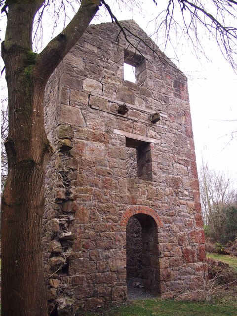
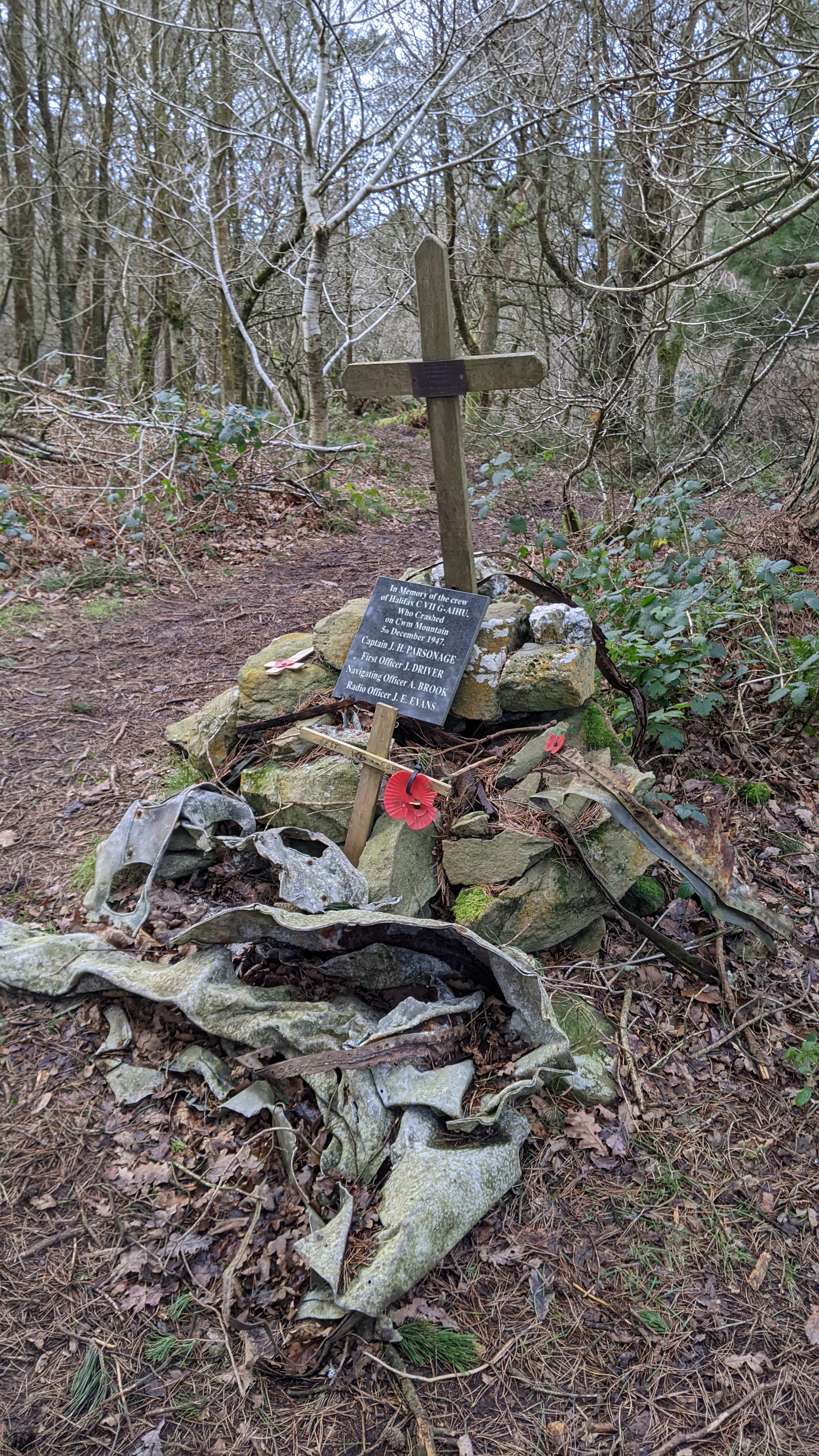
Coed Rhedyn-côch has a fascinating history, with evidence of human activity dating back hundreds of years. Remnants of ancient settlements, including a hillfort and burial mounds, can still be seen within the woodland, adding an element of historical intrigue to the area.

The forest is also home to a wide array of wildlife, making it a haven for nature enthusiasts. Birdwatchers can spot various species of birds, including woodpeckers, owls, and jays. Small mammals such as foxes, badgers, and squirrels also inhabit the woods, adding to the natural beauty and charm of the area.

Visitors to Coed Rhedyn-côch can take advantage of the picnic areas and benches scattered throughout the woodland, providing the perfect spot for a peaceful lunch or a moment of relaxation amidst nature. The forest is easily accessible, with ample parking available nearby, making it a popular destination for day trips and family outings.

Overall, Coed Rhedyn-côch offers a serene and enchanting experience for anyone seeking solace in nature, with its stunning woodland scenery, diverse wildlife, and a touch of historical intrigue.

If you have any feedback on the listing, please let us know in the comments section below.

Coed Rhedyn-côch Images

Images are sourced within 2km of 53.280985/-3.3787884 or Grid Reference SJ0876. Thanks to Geograph Open Source API. All images are credited.

The village church at Cwm near Dyserth
On the Offa's Dyke Path north of Tyddyn-y-cyll with view to Gop Hill
Engine House, Pennant Mine
A peep at Hendre Bach Hidden behind large bushes
A peep at Hendre Bach
Hidden behind large bushes
A55 eastbound near Rhuallt
Blwch Post Sioraidd / A Georgian Postbox
Clytwaith o gaeau Dyffryn Clwyd / A patchwork of fields in the Vale of Clwyd
Tan-y-Bryn
Tan-y-Bryn
A55 westbound
A55 westbound
Tombstone of Grace Williams (d. 1642) An elaborate hooded tomb.
Tombstone of Grace Williams (d. 1642)
An elaborate hooded tomb.
Bridge over the A55 The A55 is also known as the North Wales expressway. Originally it ran from Chester to Bangor, but was extended in 2001 across Anglesey to Holyhead. It is dual carriageway along its entire length.
Wikipedia: <span class="nowrap"><a title="http://en.wikipedia.org/wiki/A55_road" rel="nofollow ugc noopener" href="http://en.wikipedia.org/wiki/A55_road">Link</a><img style="margin-left:2px;" alt="External link" title="External link - shift click to open in new window" src="https://s1.geograph.org.uk/img/external.png" width="10" height="10"/></span>
Bridge over the A55
The A55 is also known as the North Wales expressway. Originally it ran from Chester to Bangor, but was extended in 2001 across Anglesey to Holyhead. It is dual carriageway along its entire length. Wikipedia: LinkExternal link
Rock cutting, A55 The A55 is also known as the North Wales expressway. Originally it ran from Chester to Bangor, but was extended in 2001 across Anglesey to Holyhead. It is dual carriageway along its entire length.
Wikipedia: <span class="nowrap"><a title="http://en.wikipedia.org/wiki/A55_road" rel="nofollow ugc noopener" href="http://en.wikipedia.org/wiki/A55_road">Link</a><img style="margin-left:2px;" alt="External link" title="External link - shift click to open in new window" src="https://s1.geograph.org.uk/img/external.png" width="10" height="10"/></span>
Rock cutting, A55
The A55 is also known as the North Wales expressway. Originally it ran from Chester to Bangor, but was extended in 2001 across Anglesey to Holyhead. It is dual carriageway along its entire length. Wikipedia: LinkExternal link
A55, Junction 29 The A55 is also known as the North Wales expressway. Originally it ran from Chester to Bangor, but was extended in 2001 across Anglesey to Holyhead. It is dual carriageway along its entire length.
Wikipedia: <span class="nowrap"><a title="http://en.wikipedia.org/wiki/A55_road" rel="nofollow ugc noopener" href="http://en.wikipedia.org/wiki/A55_road">Link</a><img style="margin-left:2px;" alt="External link" title="External link - shift click to open in new window" src="https://s1.geograph.org.uk/img/external.png" width="10" height="10"/></span>
A55, Junction 29
The A55 is also known as the North Wales expressway. Originally it ran from Chester to Bangor, but was extended in 2001 across Anglesey to Holyhead. It is dual carriageway along its entire length. Wikipedia: LinkExternal link
A55, Rhuallt Hill The A55 is also known as the North Wales expressway. Originally it ran from Chester to Bangor, but was extended in 2001 across Anglesey to Holyhead. It is dual carriageway along its entire length.
Wikipedia: <span class="nowrap"><a title="http://en.wikipedia.org/wiki/A55_road" rel="nofollow ugc noopener" href="http://en.wikipedia.org/wiki/A55_road">Link</a><img style="margin-left:2px;" alt="External link" title="External link - shift click to open in new window" src="https://s1.geograph.org.uk/img/external.png" width="10" height="10"/></span>
A55, Rhuallt Hill
The A55 is also known as the North Wales expressway. Originally it ran from Chester to Bangor, but was extended in 2001 across Anglesey to Holyhead. It is dual carriageway along its entire length. Wikipedia: LinkExternal link
Footbridge crosses the A55 The A55 is also known as the North Wales expressway. Originally it ran from Chester to Bangor, but was extended in 2001 across Anglesey to Holyhead. It is dual carriageway along its entire length.
Wikipedia: <span class="nowrap"><a title="http://en.wikipedia.org/wiki/A55_road" rel="nofollow ugc noopener" href="http://en.wikipedia.org/wiki/A55_road">Link</a><img style="margin-left:2px;" alt="External link" title="External link - shift click to open in new window" src="https://s1.geograph.org.uk/img/external.png" width="10" height="10"/></span>
Footbridge crosses the A55
The A55 is also known as the North Wales expressway. Originally it ran from Chester to Bangor, but was extended in 2001 across Anglesey to Holyhead. It is dual carriageway along its entire length. Wikipedia: LinkExternal link
Descending Rhuallt Hill The A55 is also known as the North Wales expressway. Originally it ran from Chester to Bangor, but was extended in 2001 across Anglesey to Holyhead. It is dual carriageway along its entire length.
Wikipedia: <span class="nowrap"><a title="http://en.wikipedia.org/wiki/A55_road" rel="nofollow ugc noopener" href="http://en.wikipedia.org/wiki/A55_road">Link</a><img style="margin-left:2px;" alt="External link" title="External link - shift click to open in new window" src="https://s1.geograph.org.uk/img/external.png" width="10" height="10"/></span>
Descending Rhuallt Hill
The A55 is also known as the North Wales expressway. Originally it ran from Chester to Bangor, but was extended in 2001 across Anglesey to Holyhead. It is dual carriageway along its entire length. Wikipedia: LinkExternal link
Mynydd y Cwm in Coed Cwm Walked up from east on good tract from forest road and as Des Taylor says the cairn looks chair like. You need to do this hill with neighbouring HUMP to see what the view could look like, Moel Maenefa.

Name: Mynydd y Cwm
Hill number: 2051
Height: 304.8m / 1000ft
Area: 30C: Llandudno to Wrexham
Class: Ma
Grid ref: SJ 07307 76735
Summit feature: ground 6m E of cairn
Drop: 150m
Col: 154.8m  SJ 17432 67786
Mynydd y Cwm in Coed Cwm
Walked up from east on good tract from forest road and as Des Taylor says the cairn looks chair like. You need to do this hill with neighbouring HUMP to see what the view could look like, Moel Maenefa. Name: Mynydd y Cwm Hill number: 2051 Height: 304.8m / 1000ft Area: 30C: Llandudno to Wrexham Class: Ma Grid ref: SJ 07307 76735 Summit feature: ground 6m E of cairn Drop: 150m Col: 154.8m SJ 17432 67786
Bridleway not accessible for horseriding today! Due to very deep drifts remaining after unseasonably late snowfall.  Fortunately frozen hard enough for me to walk over with care. In the distance, the village of Trelawnyd with Gop Hill behind
Bridleway not accessible for horseriding today!
Due to very deep drifts remaining after unseasonably late snowfall. Fortunately frozen hard enough for me to walk over with care. In the distance, the village of Trelawnyd with Gop Hill behind
Show me another place!

Coed Rhedyn-côch is located at Grid Ref: SJ0876 (Lat: 53.280985, Lng: -3.3787884)

Unitary Authority: Denbighshire

Police Authority: North Wales

What 3 Words

///enthused.exist.succeed. Near Cwm, Denbighshire

Nearby Locations

Coed Rhedyn-côch

Related Wikis

Mynydd y Cwm

Mynydd y Cwm is a hill in the Clwydian Range in Denbighshire, North Wales. It reaches a height of 304.8 metres (1,000 feet). It has recently been promoted...
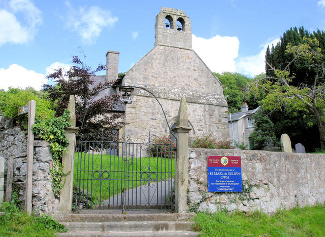
Cwm, Denbighshire

Cwm is a village and community in Denbighshire, below the hill Mynydd y Cwm. The church in Cwm is dedicated to two 6th-century saints, St Mael and St Sulien...

Rhuallt

Rhuallt is a village in Denbighshire, Wales. The village is situated approximately 5 mi (8.0 km) south of Prestatyn and 2 mi (3.2 km) east of St Asaph...

Hendre Bach

Hendre Bach is a Site of Special Scientific Interest in the preserved county of Clwyd, north Wales. == See also == List of Sites of Special Scientific...

Nearby Amenities

Located within 500m of 53.280985,-3.3787884
Natural: spring
Lat/Long: 53.2820396/-3.3748476
Natural: spring
Lat/Long: 53.2835693/-3.3732053
Natural: spring
Lat/Long: 53.284134/-3.3810201
Natural: spring
Lat/Long: 53.2837748/-3.3745912
Natural: spring
Lat/Long: 53.280977/-3.37618
The data included in this document is from www.openstreetmap.org. The data is made available under ODbL.

Have you been to Coed Rhedyn-côch?

Leave your review of Coed Rhedyn-côch below (or comments, questions and feedback).