Coed Brwynog
Wood, Forest in Merionethshire
Wales
Coed Brwynog

Coed Brwynog is a stunning woodland located in the county of Merionethshire, Wales. Spread across a vast area, it is known for its picturesque beauty and rich biodiversity. The name itself translates to "Wood, Forest" in English, which perfectly captures the essence of this natural wonder.
This woodland is characterized by its diverse range of tree species, including oak, beech, birch, and pine. The lush green foliage creates a serene and peaceful atmosphere, making it a popular destination for nature lovers and hikers. The floor of the forest is covered in a thick carpet of moss, adding to the enchanting ambiance.
Coed Brwynog is home to a variety of wildlife, making it an important ecological site. Birdwatchers can spot numerous species, such as woodpeckers, owls, and songbirds. The forest is also inhabited by small mammals like foxes, rabbits, and squirrels. Rare and protected species like the red squirrel and pine marten can sometimes be seen, adding to the area's conservation value.
Visitors can explore the woodland through its well-maintained trails, which offer breathtaking views of the surrounding landscape. The forest also holds historical significance, with remnants of ancient settlements and burial grounds scattered throughout. This makes Coed Brwynog not only a natural sanctuary but also a cultural heritage site.
Overall, Coed Brwynog in Merionethshire is a captivating woodland that showcases the beauty of nature in its purest form. With its diverse flora and fauna, stunning landscapes, and historical importance, it is a must-visit destination for those seeking tranquility and a connection with the natural world.
If you have any feedback on the listing, please let us know in the comments section below.
Coed Brwynog Images
Images are sourced within 2km of 52.93156/-3.3975148 or Grid Reference SJ0638. Thanks to Geograph Open Source API. All images are credited.


Coed Brwynog is located at Grid Ref: SJ0638 (Lat: 52.93156, Lng: -3.3975148)
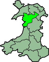
Unitary Authority: Denbighshire
Police Authority: North Wales
What 3 Words
///reduction.banter.drum. Near Llandrillo, Denbighshire
Nearby Locations
Related Wikis
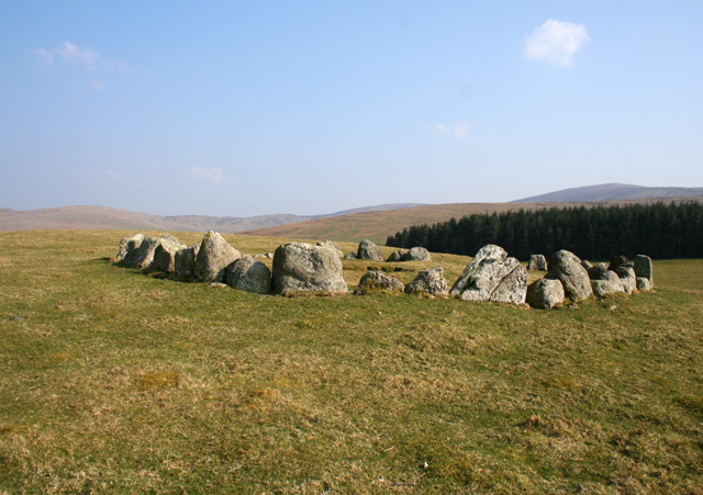
Moel Tŷ Uchaf
Moel Tŷ Uchaf is a stone circle (but most likely a ring cairn) near the village of Llandrillo, Denbighshire, north Wales. It is a collection of 41 stones...

Berwyn range
The Berwyn range (Welsh: Y Berwyn or Mynydd y Berwyn) is an isolated and sparsely populated area of moorland in the northeast of Wales, roughly bounded...
Edeirnion
Edeirnion or Edeyrnion is an area of the county of Denbighshire and an ancient commote of medieval Wales in the cantref of Penllyn. According to tradition...

Llandrillo, Denbighshire
Llandrillo (or, in full, Llandrillo yn Edeirnion) is a small village and community in the Edeirnion area of Denbighshire in Wales, between Bala, and Corwen...
Nearby Amenities
Located within 500m of 52.93156,-3.3975148Have you been to Coed Brwynog?
Leave your review of Coed Brwynog below (or comments, questions and feedback).