Great Park

Wood, Forest in Radnorshire

Wales

Great Park

Glyndwr's Way near Tyfaenor Park
Glyndwr's Way near Tyfaenor Park Credit: Dave Kelly

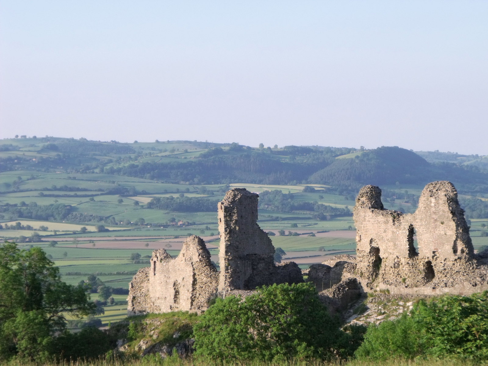
Great Park, Radnorshire, also known as Wood or Forest, is a stunning natural attraction located in the county of Radnorshire, Wales. Spanning over a vast area of land, this park is renowned for its picturesque landscapes, diverse wildlife, and rich historical significance.

Covering a total area of approximately 500 hectares, Great Park is predominantly covered by dense woodlands that showcase a wide variety of tree species, including oak, beech, and spruce. These ancient woodlands provide a haven for numerous wildlife species, such as red deer, badgers, foxes, and a plethora of bird species. It is a paradise for nature enthusiasts and photographers alike.

The park also boasts several walking trails and hiking paths, allowing visitors to explore its enchanting beauty at their own pace. These paths wind through the woods, offering breathtaking views of the surrounding countryside and glimpses of the park's hidden treasures.

Great Park holds significant historical importance as well. It was once a hunting ground for the nobility during the medieval period and still contains remnants of ancient deer parks and hunting lodges. The park's rich history is evident in its ancient trees and remnants of old stone walls.

For those seeking tranquility and a connection with nature, Great Park, Radnorshire is the perfect destination. With its diverse wildlife, stunning woodlands, and historical significance, it offers a unique experience to visitors from all walks of life. Whether you are an avid nature lover, history enthusiast, or simply seeking a peaceful retreat, Great Park is a must-visit destination.

If you have any feedback on the listing, please let us know in the comments section below.

Great Park Images

Images are sourced within 2km of 52.334884/-3.3852441 or Grid Reference SO0571. Thanks to Geograph Open Source API. All images are credited.

Glyndwr's Way near Tyfaenor Park
Glyndwr's Way near Abbeycwmhir
Glyndwr's Way near Cwmysgawen A horse stile on the path
Glyndwr's Way near Cwmysgawen
A horse stile on the path
Bridge over Cwm Poeth Brook at Abbeycwmhir This stone bridge allows access to St Mary's churchyard from the nearby hall. The single-span footbridge with its attached walls is grade II-listed (Cadw Building ID: 83092 <span class="nowrap"><a title="http://www.britishlistedbuildings.co.uk/wa-83092-footbridge-attached-walls-and-gateway-on-#.VxPdcP_mqHs" rel="nofollow ugc noopener" href="http://www.britishlistedbuildings.co.uk/wa-83092-footbridge-attached-walls-and-gateway-on-#.VxPdcP_mqHs">Link</a><img style="margin-left:2px;" alt="External link" title="External link - shift click to open in new window" src="https://s1.geograph.org.uk/img/external.png" width="10" height="10"/></span>  British Listed Buildings)
Bridge over Cwm Poeth Brook at Abbeycwmhir
This stone bridge allows access to St Mary's churchyard from the nearby hall. The single-span footbridge with its attached walls is grade II-listed (Cadw Building ID: 83092 LinkExternal link British Listed Buildings)
Parish Church of St Mary, Abbeycwmhir The current church was built in 1856 at the expense of Miss Mary Beatrice Philips, a sister to the Squire George Henry Philips of the adjacent Hall <a title="https://www.geograph.org.uk/photo/1445756" href="https://www.geograph.org.uk/photo/1445756">Link</a>. 
The current building, in Victorian Gothic revival style, replaced that built in 1680 by Sir William Fowler a little to the south, of which no trace remains. The earlier building which was dedicated to St Bridget incorporated carved stonework from the nearby Abbey none of which has been preserved in this church.
Cwm Poeth brook runs through the churchyard and into a culvert under the road, eventually emerging below Home Farm before joining Clywedog Brook. A stone bridge leads over Cwm Poeth from the churchyard to The Hall.

Clwyd Powys Archaeological Trust Radnorshire churches survey <span class="nowrap"><a title="https://cpat.org.uk/Archive/churches/radnor/16703.htm" rel="nofollow ugc noopener" href="https://cpat.org.uk/Archive/churches/radnor/16703.htm">Link</a><img style="margin-left:2px;" alt="External link" title="External link - shift click to open in new window" src="https://s1.geograph.org.uk/img/external.png" width="10" height="10"/></span>
Castles of Wales page <span class="nowrap"><a title="http://www.castlewales.com/cwmhr_ch.html" rel="nofollow ugc noopener" href="http://www.castlewales.com/cwmhr_ch.html">Link</a><img style="margin-left:2px;" alt="External link" title="External link - shift click to open in new window" src="https://s1.geograph.org.uk/img/external.png" width="10" height="10"/></span>

The church, bridge and Abbey ruins are all listed Grade II*.
Parish Church of St Mary, Abbeycwmhir
The current church was built in 1856 at the expense of Miss Mary Beatrice Philips, a sister to the Squire George Henry Philips of the adjacent Hall Link. The current building, in Victorian Gothic revival style, replaced that built in 1680 by Sir William Fowler a little to the south, of which no trace remains. The earlier building which was dedicated to St Bridget incorporated carved stonework from the nearby Abbey none of which has been preserved in this church. Cwm Poeth brook runs through the churchyard and into a culvert under the road, eventually emerging below Home Farm before joining Clywedog Brook. A stone bridge leads over Cwm Poeth from the churchyard to The Hall. Clwyd Powys Archaeological Trust Radnorshire churches survey LinkExternal link Castles of Wales page LinkExternal link The church, bridge and Abbey ruins are all listed Grade II*.
Railings Detail, St Mary's Church, Abbeycwmhir The current church was built in 1856 at the expense of Miss Mary Beatrice Philips, a sister to the Squire George Henry Philips of the adjacent Hall <a title="https://www.geograph.org.uk/photo/1445756" href="https://www.geograph.org.uk/photo/1445756">Link</a>. 
The current building, in Victorian Gothic revival style, replaced that built in 1680 by Sir William Fowler a little to the south, of which no trace remains. The earlier building which was dedicated to St Bridget incorporated carved stonework from the nearby Abbey none of which has been preserved in this church.
Cwm Poeth brook runs through the churchyard and into a culvert under the road, eventually emerging below Home Farm before joining Clywedog Brook. A stone bridge leads over Cwm Poeth from the churchyard to The Hall.

Clwyd Powys Archaeological Trust Radnorshire churches survey <span class="nowrap"><a title="https://cpat.org.uk/Archive/churches/radnor/16703.htm" rel="nofollow ugc noopener" href="https://cpat.org.uk/Archive/churches/radnor/16703.htm">Link</a><img style="margin-left:2px;" alt="External link" title="External link - shift click to open in new window" src="https://s1.geograph.org.uk/img/external.png" width="10" height="10"/></span>
Castles of Wales page <span class="nowrap"><a title="http://www.castlewales.com/cwmhr_ch.html" rel="nofollow ugc noopener" href="http://www.castlewales.com/cwmhr_ch.html">Link</a><img style="margin-left:2px;" alt="External link" title="External link - shift click to open in new window" src="https://s1.geograph.org.uk/img/external.png" width="10" height="10"/></span>

The church, bridge and Abbey ruins are all listed Grade II*.
Railings Detail, St Mary's Church, Abbeycwmhir
The current church was built in 1856 at the expense of Miss Mary Beatrice Philips, a sister to the Squire George Henry Philips of the adjacent Hall Link. The current building, in Victorian Gothic revival style, replaced that built in 1680 by Sir William Fowler a little to the south, of which no trace remains. The earlier building which was dedicated to St Bridget incorporated carved stonework from the nearby Abbey none of which has been preserved in this church. Cwm Poeth brook runs through the churchyard and into a culvert under the road, eventually emerging below Home Farm before joining Clywedog Brook. A stone bridge leads over Cwm Poeth from the churchyard to The Hall. Clwyd Powys Archaeological Trust Radnorshire churches survey LinkExternal link Castles of Wales page LinkExternal link The church, bridge and Abbey ruins are all listed Grade II*.
Abbey-Cwm-Hir Abbeycwmhir (Abaty Cwm Hir, "Abbey in the Long Valley") is a remote village in the valley of the Nant Clywedog. The village is named after Cwmhir Abbey, the Cistercian abbey built there in 1143.
Abbey-Cwm-Hir
Abbeycwmhir (Abaty Cwm Hir, "Abbey in the Long Valley") is a remote village in the valley of the Nant Clywedog. The village is named after Cwmhir Abbey, the Cistercian abbey built there in 1143.
Abbeycwmhir Village Centre Abbeycwmhir (Abaty Cwm Hir, "Abbey in the Long Valley") is a remote village in the valley of the Nant Clywedog. The village is named after Cwmhir Abbey, the Cistercian abbey built there in 1143.
Abbeycwmhir Village Centre
Abbeycwmhir (Abaty Cwm Hir, "Abbey in the Long Valley") is a remote village in the valley of the Nant Clywedog. The village is named after Cwmhir Abbey, the Cistercian abbey built there in 1143.
Abbeycwmhir Telephone Kiosk Abbeycwmhir (Abaty Cwm Hir, "Abbey in the Long Valley") is a remote village in the valley of the Nant Clywedog. The village is named after Cwmhir Abbey, the Cistercian abbey built there in 1143.
Abbeycwmhir Telephone Kiosk
Abbeycwmhir (Abaty Cwm Hir, "Abbey in the Long Valley") is a remote village in the valley of the Nant Clywedog. The village is named after Cwmhir Abbey, the Cistercian abbey built there in 1143.
Cwmhir Abbey (Abaty Cwm Hir) The ruins of Abbey Cwmhir lie in the secluded valley of the Clywedog brook in a remote location typical of those chosen by the Cistercian order. The abbey was built in 1176, probably under the patronage of Cadwallon ap Madog of Maelienydd, as this area of Powys was then called.
The abbey was badly damaged in 1401-2 during the revolt of Owen Glyndwr who believed the English monks to be spies. At the time of dissolution in 1537 there were only three monks here.
Little survives of the abbey buildings and only the nave of the church, the largest in Wales,  still stands. Stone from the abbey was used in the construction of the 17th century church (since demolished) and The Hall.
The nearby mound and boating lake are part of the 19th century landscaping around the adjacent Hall <a title="https://www.geograph.org.uk/photo/1445756" href="https://www.geograph.org.uk/photo/1445756">Link</a>.

Clwyd Powys Archaeological Trust <span class="nowrap"><a title="http://www.cpat.org.uk/projects/longer/abbeyc/abbeyc.htm" rel="nofollow ugc noopener" href="http://www.cpat.org.uk/projects/longer/abbeyc/abbeyc.htm">Link</a><img style="margin-left:2px;" alt="External link" title="External link - shift click to open in new window" src="https://s1.geograph.org.uk/img/external.png" width="10" height="10"/></span>
Castles of Wales page <span class="nowrap"><a title="http://www.castlewales.com/cwmhir.html" rel="nofollow ugc noopener" href="http://www.castlewales.com/cwmhir.html">Link</a><img style="margin-left:2px;" alt="External link" title="External link - shift click to open in new window" src="https://s1.geograph.org.uk/img/external.png" width="10" height="10"/></span>

The abbey ruins are Grade II* listed.
Cwmhir Abbey (Abaty Cwm Hir)
The ruins of Abbey Cwmhir lie in the secluded valley of the Clywedog brook in a remote location typical of those chosen by the Cistercian order. The abbey was built in 1176, probably under the patronage of Cadwallon ap Madog of Maelienydd, as this area of Powys was then called. The abbey was badly damaged in 1401-2 during the revolt of Owen Glyndwr who believed the English monks to be spies. At the time of dissolution in 1537 there were only three monks here. Little survives of the abbey buildings and only the nave of the church, the largest in Wales, still stands. Stone from the abbey was used in the construction of the 17th century church (since demolished) and The Hall. The nearby mound and boating lake are part of the 19th century landscaping around the adjacent Hall Link. Clwyd Powys Archaeological Trust LinkExternal link Castles of Wales page LinkExternal link The abbey ruins are Grade II* listed.
Cistercian Abbey Ruins, Cwmhir Abbey (Abaty Cwm Hir) The ruins of Abbey Cwmhir lie in the secluded valley of the Clywedog brook in a remote location typical of those chosen by the Cistercian order. The abbey was built in 1176, probably under the patronage of Cadwallon ap Madog of Maelienydd, as this area of Powys was then called.
The abbey was badly damaged in 1401-2 during the revolt of Owen Glyndwr who believed the English monks to be spies. At the time of dissolution in 1537 there were only three monks here.
Little survives of the abbey buildings and only the nave of the church, the largest in Wales,  still stands. Stone from the abbey was used in the construction of the 17th century church (since demolished) and The Hall.
The nearby mound and boating lake are part of the 19th century landscaping around the adjacent Hall <a title="https://www.geograph.org.uk/photo/1445756" href="https://www.geograph.org.uk/photo/1445756">Link</a>.

Clwyd Powys Archaeological Trust <span class="nowrap"><a title="http://www.cpat.org.uk/projects/longer/abbeyc/abbeyc.htm" rel="nofollow ugc noopener" href="http://www.cpat.org.uk/projects/longer/abbeyc/abbeyc.htm">Link</a><img style="margin-left:2px;" alt="External link" title="External link - shift click to open in new window" src="https://s1.geograph.org.uk/img/external.png" width="10" height="10"/></span>
Castles of Wales page <span class="nowrap"><a title="http://www.castlewales.com/cwmhir.html" rel="nofollow ugc noopener" href="http://www.castlewales.com/cwmhir.html">Link</a><img style="margin-left:2px;" alt="External link" title="External link - shift click to open in new window" src="https://s1.geograph.org.uk/img/external.png" width="10" height="10"/></span>

The abbey ruins are Grade II* listed.
Cistercian Abbey Ruins, Cwmhir Abbey (Abaty Cwm Hir)
The ruins of Abbey Cwmhir lie in the secluded valley of the Clywedog brook in a remote location typical of those chosen by the Cistercian order. The abbey was built in 1176, probably under the patronage of Cadwallon ap Madog of Maelienydd, as this area of Powys was then called. The abbey was badly damaged in 1401-2 during the revolt of Owen Glyndwr who believed the English monks to be spies. At the time of dissolution in 1537 there were only three monks here. Little survives of the abbey buildings and only the nave of the church, the largest in Wales, still stands. Stone from the abbey was used in the construction of the 17th century church (since demolished) and The Hall. The nearby mound and boating lake are part of the 19th century landscaping around the adjacent Hall Link. Clwyd Powys Archaeological Trust LinkExternal link Castles of Wales page LinkExternal link The abbey ruins are Grade II* listed.
Cwmhir Abbey (Abaty Cwm Hir) Ruins The remains of the Cistercian abbey, viewed from the south-east.
Cwmhir Abbey (Abaty Cwm Hir) Ruins
The remains of the Cistercian abbey, viewed from the south-east.
Lake at Abbey-Cwm-Hir The lake, just to the south of the ruined abbey, was built as part of the 19th century landscaping associated with the nearby hall.
Lake at Abbey-Cwm-Hir
The lake, just to the south of the ruined abbey, was built as part of the 19th century landscaping associated with the nearby hall.
Clywedog Brook at Abbey-Cwm-Hir Water drains from the lake into Clywedog Brook.
Clywedog Brook at Abbey-Cwm-Hir
Water drains from the lake into Clywedog Brook.
Lake and Ruined Abbey, Abbey-Cwm-Hir The ruins of Abbey Cwmhir lie in the secluded valley of the Clywedog brook in a remote location typical of those chosen by the Cistercian order. The abbey was built in 1176, probably under the patronage of Cadwallon ap Madog of Maelienydd, as this area of Powys was then called.
The abbey was badly damaged in 1401-2 during the revolt of Owen Glyndwr who believed the English monks to be spies. At the time of dissolution in 1537 there were only three monks here.
Little survives of the abbey buildings and only the nave of the church, the largest in Wales,  still stands. Stone from the abbey was used in the construction of the 17th century church (since demolished) and The Hall.
The nearby mound and boating lake are part of the 19th century landscaping around the adjacent Hall <a title="https://www.geograph.org.uk/photo/1445756" href="https://www.geograph.org.uk/photo/1445756">Link</a>.

Clwyd Powys Archaeological Trust <span class="nowrap"><a title="http://www.cpat.org.uk/projects/longer/abbeyc/abbeyc.htm" rel="nofollow ugc noopener" href="http://www.cpat.org.uk/projects/longer/abbeyc/abbeyc.htm">Link</a><img style="margin-left:2px;" alt="External link" title="External link - shift click to open in new window" src="https://s1.geograph.org.uk/img/external.png" width="10" height="10"/></span>
Castles of Wales page <span class="nowrap"><a title="http://www.castlewales.com/cwmhir.html" rel="nofollow ugc noopener" href="http://www.castlewales.com/cwmhir.html">Link</a><img style="margin-left:2px;" alt="External link" title="External link - shift click to open in new window" src="https://s1.geograph.org.uk/img/external.png" width="10" height="10"/></span>

The abbey ruins are Grade II* listed.
Lake and Ruined Abbey, Abbey-Cwm-Hir
The ruins of Abbey Cwmhir lie in the secluded valley of the Clywedog brook in a remote location typical of those chosen by the Cistercian order. The abbey was built in 1176, probably under the patronage of Cadwallon ap Madog of Maelienydd, as this area of Powys was then called. The abbey was badly damaged in 1401-2 during the revolt of Owen Glyndwr who believed the English monks to be spies. At the time of dissolution in 1537 there were only three monks here. Little survives of the abbey buildings and only the nave of the church, the largest in Wales, still stands. Stone from the abbey was used in the construction of the 17th century church (since demolished) and The Hall. The nearby mound and boating lake are part of the 19th century landscaping around the adjacent Hall Link. Clwyd Powys Archaeological Trust LinkExternal link Castles of Wales page LinkExternal link The abbey ruins are Grade II* listed.
Abaty Cwm Hir (Cwmhir Abbey) Ruins and Lake The ruins of Abbey Cwmhir lie in the secluded valley of the Clywedog brook in a remote location typical of those chosen by the Cistercian order. The abbey was built in 1176, probably under the patronage of Cadwallon ap Madog of Maelienydd, as this area of Powys was then called.
The abbey was badly damaged in 1401-2 during the revolt of Owen Glyndwr who believed the English monks to be spies. At the time of dissolution in 1537 there were only three monks here.
Little survives of the abbey buildings and only the nave of the church, the largest in Wales,  still stands. Stone from the abbey was used in the construction of the 17th century church (since demolished) and The Hall.
The nearby mound and boating lake are part of the 19th century landscaping around the adjacent Hall <a title="https://www.geograph.org.uk/photo/1445756" href="https://www.geograph.org.uk/photo/1445756">Link</a>.

Clwyd Powys Archaeological Trust <span class="nowrap"><a title="http://www.cpat.org.uk/projects/longer/abbeyc/abbeyc.htm" rel="nofollow ugc noopener" href="http://www.cpat.org.uk/projects/longer/abbeyc/abbeyc.htm">Link</a><img style="margin-left:2px;" alt="External link" title="External link - shift click to open in new window" src="https://s1.geograph.org.uk/img/external.png" width="10" height="10"/></span>
Castles of Wales page <span class="nowrap"><a title="http://www.castlewales.com/cwmhir.html" rel="nofollow ugc noopener" href="http://www.castlewales.com/cwmhir.html">Link</a><img style="margin-left:2px;" alt="External link" title="External link - shift click to open in new window" src="https://s1.geograph.org.uk/img/external.png" width="10" height="10"/></span>

The abbey ruins are Grade II* listed.
Abaty Cwm Hir (Cwmhir Abbey) Ruins and Lake
The ruins of Abbey Cwmhir lie in the secluded valley of the Clywedog brook in a remote location typical of those chosen by the Cistercian order. The abbey was built in 1176, probably under the patronage of Cadwallon ap Madog of Maelienydd, as this area of Powys was then called. The abbey was badly damaged in 1401-2 during the revolt of Owen Glyndwr who believed the English monks to be spies. At the time of dissolution in 1537 there were only three monks here. Little survives of the abbey buildings and only the nave of the church, the largest in Wales, still stands. Stone from the abbey was used in the construction of the 17th century church (since demolished) and The Hall. The nearby mound and boating lake are part of the 19th century landscaping around the adjacent Hall Link. Clwyd Powys Archaeological Trust LinkExternal link Castles of Wales page LinkExternal link The abbey ruins are Grade II* listed.
Dam, Abbeycwmhir Lake Water from the lake overflows here into Cywedog Brook.
Dam, Abbeycwmhir Lake
Water from the lake overflows here into Cywedog Brook.
Abbeycwmhir Lake The lake, just to the south of the ruined abbey, was built as part of the 19th century landscaping associated with the nearby hall.
Abbeycwmhir Lake
The lake, just to the south of the ruined abbey, was built as part of the 19th century landscaping associated with the nearby hall.
Show me another place!

Great Park is located at Grid Ref: SO0571 (Lat: 52.334884, Lng: -3.3852441)

Unitary Authority: Powys

Police Authority: Dyfed Powys

What 3 Words

///crockery.expansion.attends. Near Rhayader, Powys

Related Wikis

Abbey Cwmhir Hall

Abbey-Cwm-Hir Hall is a neo-Elizabethan country house in the Welsh county of Powys. == History == The hall was built in 1833 for Thomas Wilson, a London...

Abbeycwmhir

Abbeycwmhir or Abbey Cwmhir (Welsh: Abaty Cwm Hir, "Abbey in the Long Valley") is a village and community in the valley of the Nant Clywedog in Radnorshire...

Cwmhir Abbey

Cwmhir Abbey (Welsh: Abaty Cwm Hir), near Llandrindod Wells in Powys, is a Welsh Cistercian monastery founded in 1176 by Cadwallon ap Madog. A spurious...

Powys

Powys ( POH-iss, POW-iss, Welsh: [ˈpou̯ɪs]) is a county and preserved county in Wales. It borders Gwynedd, Denbighshire, and Wrexham to the north; the...

Nearby Amenities

Located within 500m of 52.334884,-3.3852441
Turning Circle
Lat/Long: 52.334387/-3.3837287
The data included in this document is from www.openstreetmap.org. The data is made available under ODbL.

Have you been to Great Park?

Leave your review of Great Park below (or comments, questions and feedback).