Briar Covert

Wood, Forest in Flintshire

Wales

Briar Covert

Postbox at Bruton Park, Rhyl LL18 159D. Royal Mail list this box as 'Bruton Park'.
Postbox at Bruton Park, Rhyl Credit: David Bremner

Briar Covert is a picturesque woodland area located in Flintshire, Wales. Covering an area of approximately 50 acres, the forest is characterized by dense, mature trees such as oak, beech, and birch, creating a serene and tranquil environment for visitors to explore.

The woodland is home to a variety of wildlife, including deer, rabbits, and a wide array of bird species, making it a popular spot for nature enthusiasts and birdwatchers. The forest also boasts a network of well-maintained walking trails, allowing visitors to fully immerse themselves in the natural beauty of the surroundings.

Briar Covert is a designated Site of Special Scientific Interest (SSSI), due to its diverse range of plant species and unique ecological features. The forest is managed by the local council, who work to preserve and protect the natural habitat for future generations to enjoy.

Overall, Briar Covert is a hidden gem in Flintshire, offering a peaceful retreat for those looking to escape the hustle and bustle of everyday life and reconnect with nature in a pristine woodland setting.

If you have any feedback on the listing, please let us know in the comments section below.

Briar Covert Images

Images are sourced within 2km of 53.308606/-3.4450723 or Grid Reference SJ0380. Thanks to Geograph Open Source API. All images are credited.

Postbox at Bruton Park, Rhyl LL18 159D. Royal Mail list this box as 'Bruton Park'.
Postbox at Bruton Park, Rhyl
LL18 159D. Royal Mail list this box as 'Bruton Park'.
Parc Aberkinsey New housing development at Rhyl.
Parc Aberkinsey
New housing development at Rhyl.
Grosvenor Avenue, Rhyl
Trellewelyn Road, Rhyl Viewed from the junction with Grosvenor Avenue.
Trellewelyn Road, Rhyl
Viewed from the junction with Grosvenor Avenue.
Bethel Chapel The former chapel from near the top of the waterfall
Bethel Chapel
The former chapel from near the top of the waterfall
A Bit Fishy? Gurnard Place, Rhyl.
A Bit Fishy?
Gurnard Place, Rhyl.
Postbox at Rhuddlan LL18 73. Royal Mail list this box as 'Rhyl Road Rhuddlan'.
Postbox at Rhuddlan
LL18 73. Royal Mail list this box as 'Rhyl Road Rhuddlan'.
Old Boundary Marker on the B5151 at Bodrhyddan Parish Boundary Marker against a stone wall on the south side of the A5151 opposite Bodrhyddan Home Farm. Inscribed R P for Rhuddlan Parish and on the boundary of Rhuddlan and Dyserth parishes.

Milestone Society National ID: DEN_RHUDYS02pb
Old Boundary Marker on the B5151 at Bodrhyddan
Parish Boundary Marker against a stone wall on the south side of the A5151 opposite Bodrhyddan Home Farm. Inscribed R P for Rhuddlan Parish and on the boundary of Rhuddlan and Dyserth parishes. Milestone Society National ID: DEN_RHUDYS02pb
Parish boundary stone on the A5151, Dyserth Marked R.P. for Rhuddlan Parish.
Parish boundary stone on the A5151, Dyserth
Marked R.P. for Rhuddlan Parish.
Study of a Gasoline Station Sainsbury's, Rhyl.

 This photograph is part of a series taken in homage to the American artist Ed Ruscha's 1963 publication of 'Twentysix Gasoline Stations'.
 More properly known as filling stations in the UK, I am attempting to photograph as many as possible to mark the sixty year anniversary.
Study of a Gasoline Station
Sainsbury's, Rhyl. This photograph is part of a series taken in homage to the American artist Ed Ruscha's 1963 publication of 'Twentysix Gasoline Stations'. More properly known as filling stations in the UK, I am attempting to photograph as many as possible to mark the sixty year anniversary.
Epworth Road, Rhyl
Epworth Road, Rhyl
Ffordd Derwen, Rhyl
Ffordd Derwen, Rhyl
St Bridget's Parish Church, Dyserth
Ffordd Anwyl Rhyl Ffordd Anwyl - housing state in Rhyl named after the local builder
Ffordd Anwyl Rhyl
Ffordd Anwyl - housing state in Rhyl named after the local builder
Trellewelyn Road Rhyl Part of a housing estate Trellewelyn Road is a main thoroughfare through the area towards the seafront
Trellewelyn Road Rhyl
Part of a housing estate Trellewelyn Road is a main thoroughfare through the area towards the seafront
Rhydwen Farm Mews A farm recently converted into housing
Rhydwen Farm Mews
A farm recently converted into housing
Two signs The road sign marks a sharp right turn.  The footpath sign points to a poorly defined footpath.
Two signs
The road sign marks a sharp right turn. The footpath sign points to a poorly defined footpath.
Maize field and covert The woodland in the background is known as Rhydorddwy-wen Covert
Maize field and covert
The woodland in the background is known as Rhydorddwy-wen Covert
Show me another place!

Briar Covert is located at Grid Ref: SJ0380 (Lat: 53.308606, Lng: -3.4450723)

Unitary Authority: Denbighshire

Police Authority: North Wales

What 3 Words

///yoga.abundance.final. Near Dyserth, Denbighshire

Related Wikis

Bodrhyddan Hall

Bodrhyddan Hall is a country house in Rhuddlan, Denbighshire, Wales. It is a Grade I listed building.The present building is a 1690s remodelling of an...
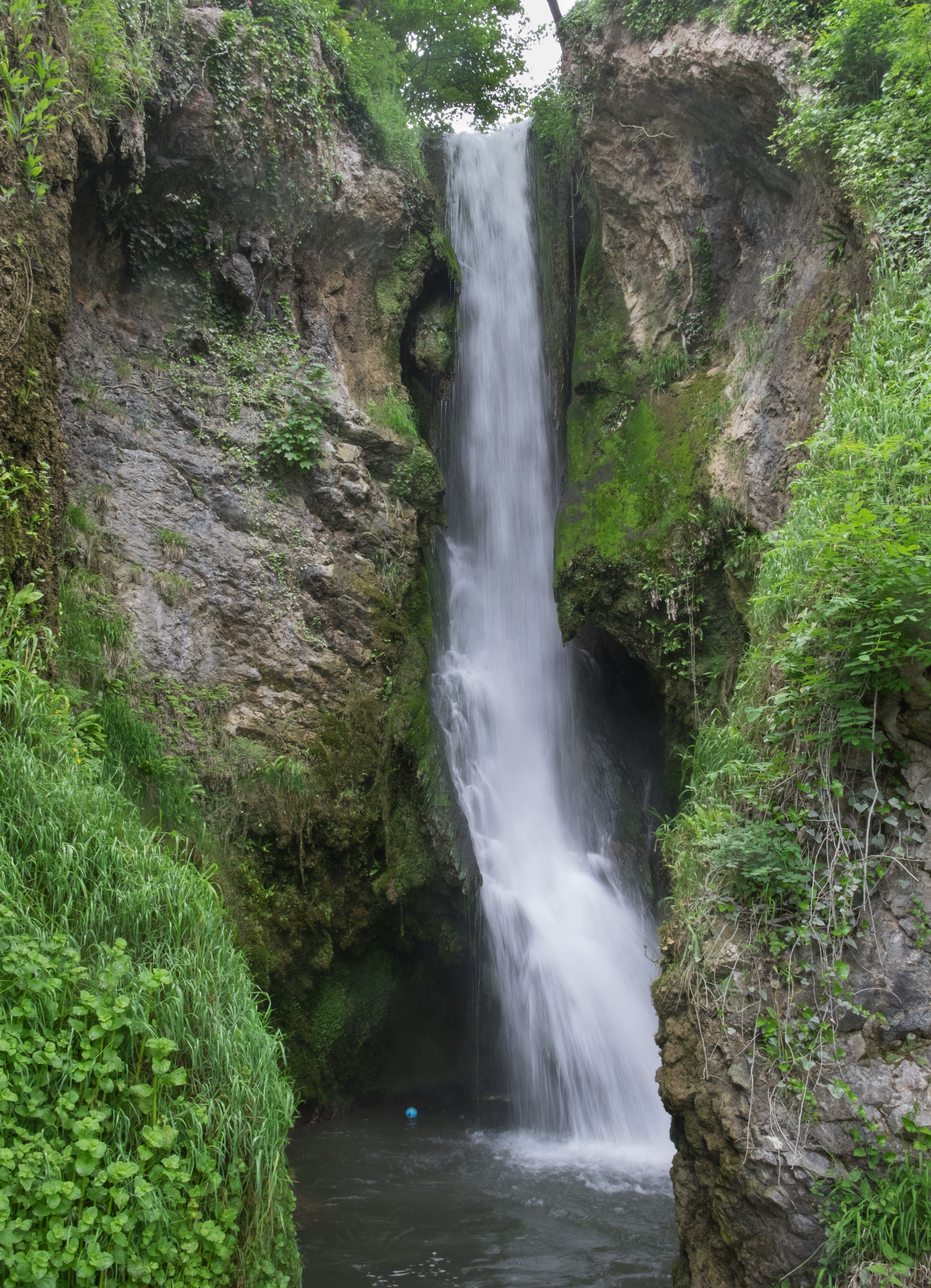
Dyserth Waterfall

Dyserth Waterfall is a waterfall in Dyserth, North Wales. The River Ffyddion, a tributary of the River Clwyd, falls down a 70-foot ledge creating the waterfall...

Alt-y-Graig railway station

Alt-y-Craig railway station (later renamed Allt-y-Graig) was an unstaffed halt on the Dyserth branch line. Like Woodland Park further down the line, passengers...
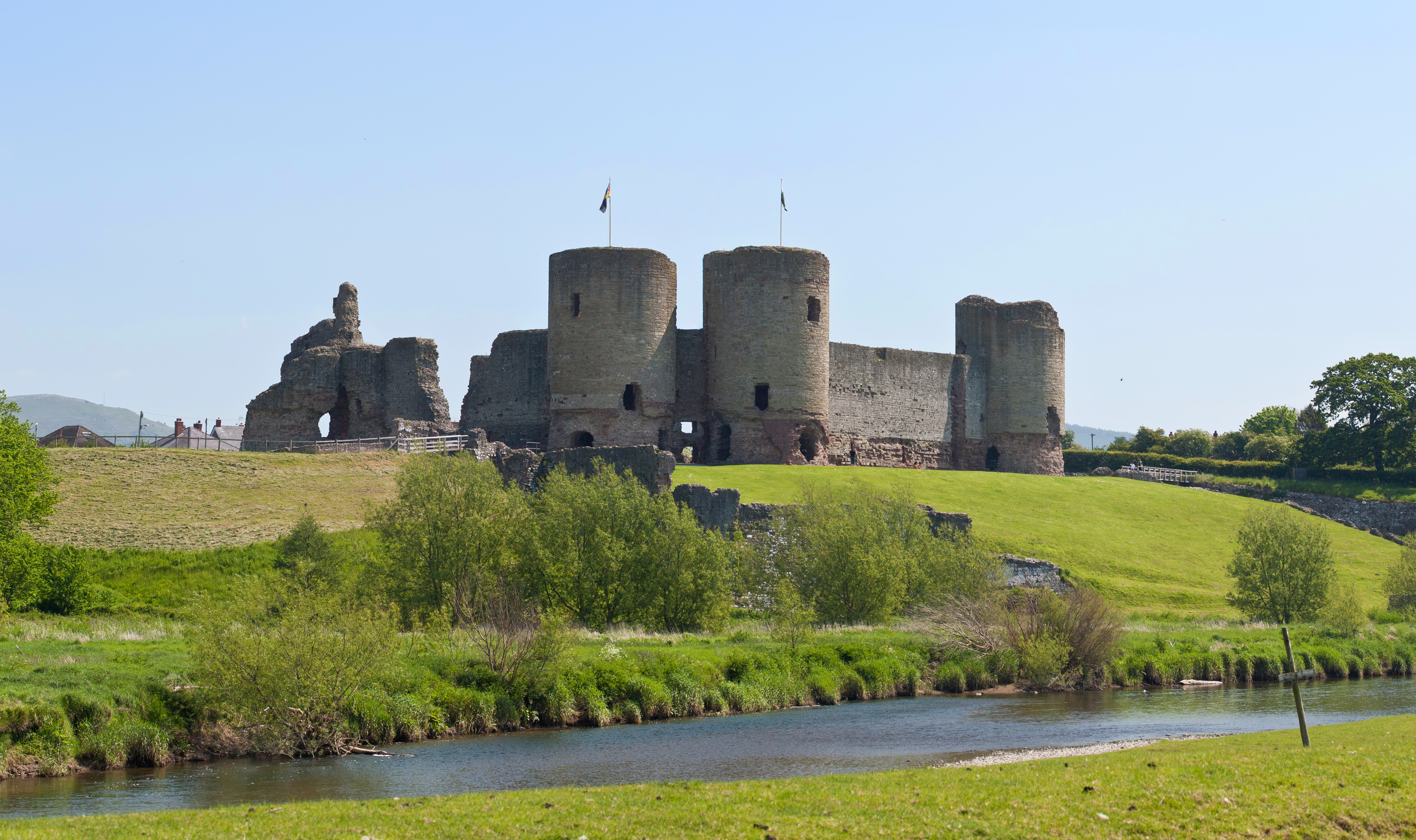
Rhuddlan

Rhuddlan (Welsh pronunciation: [ˈr̥ɨðlan]) is a town, community, and electoral ward in the county of Denbighshire, Wales, in the historic county of Flintshire...

Related Videos

Marian Mills, Dyserth Walking through history Episode 3

Join me as i explore the old mills of Dyserth, North wales. My Website https://www.andyoutdoors.net/about-andy My Instagram ...

Lyons Holiday Parks - The Best of Entertainment in North Wales

Hey there! We're pleased to present Lyons Robin Hood's premier entertainment team with a preview of their 2021 programme!

Riverbed walking, Dyserth, (River Ffyddion).

Here is the links to the videos i mentioned. Talargoch lead mine. https://www.youtube.com/watch?v=eMI7M_YIzqI&t=803s Marian ...

Cosalt Riverdal Lyons Holiday Park

Central Heating, Double Glazing, Electric Fire, Free Standing Sofas Overview Quality fixtures and fittings, ample space, and a light ...

Nearby Amenities

Located within 500m of 53.308606,-3.4450723
Crossing
Lat/Long: 53.3084263/-3.4392026
Power: pole
Lat/Long: 53.3109894/-3.4388219
Power: pole
Lat/Long: 53.3103725/-3.4395702
Power: pole
Lat/Long: 53.3091512/-3.4409266
Power: pole
Lat/Long: 53.3081945/-3.441952
Power: pole
Lat/Long: 53.3072393/-3.4430356
Power: pole
Lat/Long: 53.3064925/-3.4438215
Power: pole
Lat/Long: 53.3057424/-3.4446503
Power: pole
Lat/Long: 53.3049619/-3.4455113
Power: pole
Lat/Long: 53.3042134/-3.4463535
Power: pole
Lat/Long: 53.3097442/-3.4402274
Power: pole
Lat/Long: 53.3052267/-3.4480089
Power: pole
Lat/Long: 53.3056617/-3.4466364
Power: pole
Lat/Long: 53.3061896/-3.445804
Power: pole
Lat/Long: 53.306804/-3.4450695
Power: pole
Lat/Long: 53.3069503/-3.4440775
Power: pole
Lat/Long: 53.3072823/-3.4428023
Power: pole
Lat/Long: 53.3074349/-3.4419018
Power: pole
Lat/Long: 53.307655/-3.4408139
Power: pole
Lat/Long: 53.3078763/-3.4400379
Power: pole
Lat/Long: 53.3096011/-3.437867
Power: pole
Lat/Long: 53.3094472/-3.4384117
Power: pole
Lat/Long: 53.3091362/-3.4388298
Barrier: stile
Stile: stepover
Lat/Long: 53.3091676/-3.4485015
Barrier: stile
Stile: stepover
Lat/Long: 53.3091957/-3.4469458
Barrier: stile
Stile: stepover
Lat/Long: 53.310048/-3.4469676
The data included in this document is from www.openstreetmap.org. The data is made available under ODbL.

Have you been to Briar Covert?

Leave your review of Briar Covert below (or comments, questions and feedback).